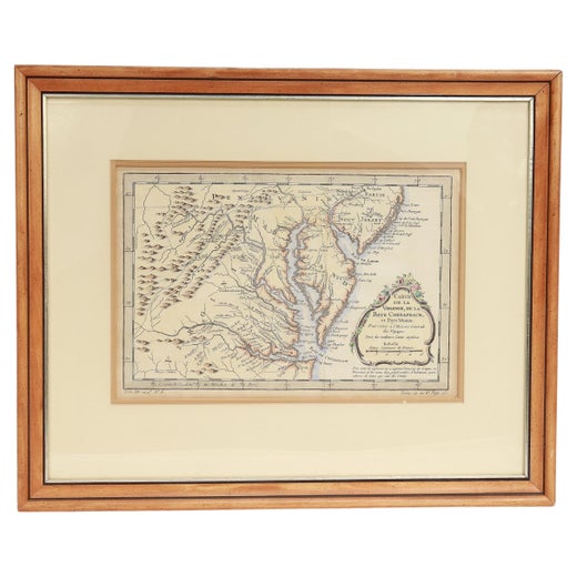
1 of 15
Jacques-Nicolas BellinAntique world map - Erdkugel and compass by Bellin - Handcol. engraving - 18th c1748
1748
$1,477.64List Price
About the Item
- Creator:Jacques-Nicolas Bellin (1703 - 1772, French)
- Creation Year:1748
- Dimensions:Height: 20.56 in (52.2 cm)Width: 28.55 in (72.5 cm)
- Medium:
- Movement & Style:
- Period:1740-1749
- Condition:Very good, given age. Original folds, as issued. Crease near cartouche. Edges reinforced on rear. Lower margin, remargined using contemporary paper backed with acid free archival tape. Please study scan carefully.
- Gallery Location:Zeeland, NL
- Reference Number:Seller: 543991stDibs: LU59235763421
Jacques-Nicolas Bellin
Jacques Nicolas Bellin (1703 –1772) was a French hydrographer (official cartographer) and a geographer. While still a teenager he became the chief cartographer to the French Navy and later to the king of France. Bellin created a large number of maps for Antoine François Prévost's (L'Abbe Prevost) 'Histoire Generale des Voyages', which was a 25 volume publication focused on 17th and 18th century exploration.It was published in French, Dutch and German. He also contributed maps and articles to the 35-volume Encyclopédie edited by Denis Diderot and Jean le Rond d'Alembert. He was part of the group called Philosophes, which included many of the great intellectuals of the Age of Enlightenment, including Voltaire, Rousseau and Montesquieu. Bellin died at Versailles in 1772.
Authenticity Guarantee
In the unlikely event there’s an issue with an item’s authenticity, contact us within 1 year for a full refund. DetailsMoney-Back Guarantee
If your item is not as described, is damaged in transit, or does not arrive, contact us within 7 days for a full refund. Details24-Hour Cancellation
You have a 24-hour grace period in which to reconsider your purchase, with no questions asked.Vetted Professional Sellers
Our world-class sellers must adhere to strict standards for service and quality, maintaining the integrity of our listings.Price-Match Guarantee
If you find that a seller listed the same item for a lower price elsewhere, we’ll match it.Trusted Global Delivery
Our best-in-class carrier network provides specialized shipping options worldwide, including custom delivery.You May Also Like
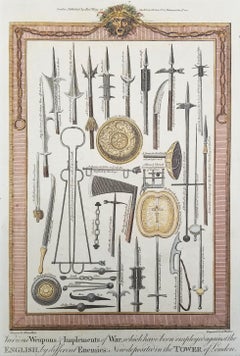
Various Weapons & Implements of War /// Edward Barnard's "History of England"
Located in Saint Augustine, FL
Artist: Edward Barnard (English, 1717-1781)
Title: "Various Weapons & Implements of War ... Which have been Employed Against the English, by Different Enemies: Now Deposited in the Tower of London"
Portfolio: New Complete and Authentic History of England
Circa: 1785
Medium: Original Hand-Colored Etching on laid paper
Limited edition: Unknown
Printer: Alex Hogg, London, UK
Publisher: Alex Hogg, London, UK
Sheet size: 15.38" x 9.63"
Image size: 11.75" x 7.94"
Condition: Slight toning to edges. Has been professionally stored away for decades. It is otherwise a strong impression in excellent condition
Notes:
Provenance: private collection - Cheltenham, UK. Engraved by English artist George Walker (1781-1856) after a drawing by English artist William Hamilton (1751-1801). Comes from Barnard's one volume "New Complete and Authentic History of England", (1783, 1785, 1790) (First - third editions), which consists of 105 engravings. Printed in one color from one copper plate: black.
Biography:
Edward Barnard (1717-1781) was an English cleric and academic, provost of Eton from 1764. Barnard was second son of Rev. George Barnard...
Category
1780s Old Masters More Prints
Materials
Watercolor, Laid Paper, Engraving, Intaglio
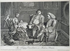
The Happy Consultation, or Modern Match
Located in Santa Monica, CA
EIGHTEENTH CENTURY BRITISH CARICATURE
THE HAPPY CONSULTATION, or MODERN MATCH, 1769 (DG 4335)
...
Category
1760s Old Masters More Prints
Materials
Engraving
Meissen, Germany : A Large Framed 18th Century Map by Petrus Schenk
Located in Alamo, CA
This is a hand-colored 18th century map of the Meissen region of Germany, entitled "Geographischer Entwurff Derer Aemmter Meissen als Creys-Procuratur-Schul-und Stiffts-Ammt benebst ...
Category
Mid-18th Century Old Masters Landscape Prints
Materials
Engraving

$940 Sale Price
20% Off
H 26.13 in W 42.13 in D 0.75 in
Canterbury: An Original 16th C. Framed Hand-colored Map by Braun & Hogenberg
By Franz Hogenberg
Located in Alamo, CA
This is a framed 16th century map and city view of Canterbury, England entitled "Cantuarbury" by Braun & Hogenburg, from their famous landmark atlas of city views 'Civitates Orbis Terrarum' (Atlas of the Cities of the World), which was first published in Cologne, Germany in 1572. The map of Canterbury was first published in 1588. It depicts a detailed birdseye view of the completely walled and fortified city of Canterbury, with its cathedral the most prominent feature. The coat of arms of England, Canterbury, and the Archbishop of Canterbury are included.
This beautifully hand-colored map is presented in a gold-colored wood frame with a beaded inner trim and a paprika-colored mat that highlights details in the map. The frame measures 18.75" high by 22.25" wide by 0.875" deep. There is a central vertical fold, as issued. The map is in excellent condition.
Braun and Hogenberg's 'The Civitates Orbis Terrarum' was the second atlas of maps ever published and the first atlas of cities and towns of the world. It is one of the most important books published in the 16th century. Most of the maps in the atlas were engraved by Franz Hogenberg and the text, with its descriptions of the history and additional factual information of the cities, was written by a team of writers and edited by Georg Braun. The work contained 546 bird-eye views and map views of cities and towns from all over the world. It gave graphic representation of the main features of the illustrated cities and towns, including the buildings and streets. Although the ordinary buildings are stylized, the principal buildings are reproduced from actual drawings created on location. The principal landmarks and streets can still be recognized today. In addition, the maps often include the heraldic arms of the city, the nature of the surrounding countryside, the important rivers, streams and harbors, even depicting stone bridges, wooden pontoons, flat-bottomed ferries, ships and working boats, wharves and jetties, as well as land-based activities, including horsemen, pedestrians, wagons, coaches, and palanquins. Small vignettes are often included which illustrate the trade, occupations and habits of the local inhabitants, such as agriculture, paper-making and textiles, as well as local forms of punishment, such as gibbets, wheels, floggings etc. Large figures dressed in their local costume are often presented out of proportion in the foreground. The aim of the authors was to give as much information as possible in a pleasing visual form. They succeeded in creating maps that were both informative and decorative works of art. The atlas is a wonderful glimpse of life in medieval Europe.
Georg Braun (1541-1622) was German Catholic...
Category
16th Century Old Masters Landscape Prints
Materials
Engraving

$1,900 Sale Price
20% Off
H 18.75 in W 22.25 in D 0.88 in
L'Isle de France: A Hand-colored 17th Century Map by De Wit
By Frederick de Wit
Located in Alamo, CA
This colorful and detailed 17th century hand-colored copperplate map by Frederick De Wit was published in Amsterdam between 1666 and 1760. The map depicts the Île-de-France, which is one of the ancient provinces of France. Paris is located in the center of the map, with Versailles to the southwest The map extends from Rouen in the west to Reims in the east. The area around Paris, the Véxin Français, was the original domain of the king of France. Other areas were ruled by French feudal lords. For example, the Véxin Normand area was the domain of the Duke of Normandy...
Category
Early 18th Century Old Masters More Prints
Materials
Engraving

$940 Sale Price
20% Off
H 28.25 in W 31.25 in D 0.75 in
"Allegory of Justice": A 17th Century Old Master Engraving by van Swanenburg
By Willem van Swanenburg
Located in Alamo, CA
This old master engraving entitled "Allegorie op de Rechtspraak" is by Willem van Swaanenburg after a painting by Joachim Wtewael, published by Ch...
Category
Early 1600s Old Masters Interior Prints
Materials
Engraving
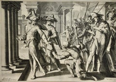
$4,620 Sale Price
20% Off
H 10.75 in W 15 in
Danube River, Italy, Greece and Croatia: A Hand-colored 18th C. Homann Map
By Johann Baptist Homann
Located in Alamo, CA
"Fluviorum in Europa principis Danubii" is a hand-colored map of the region about the Danube river created by Johann Baptist Homann (1663-1724) in his 'Atlas Novus Terrarum', publish...
Category
Early 18th Century Old Masters Landscape Prints
Materials
Engraving

$700 Sale Price
20% Off
H 20 in W 23.88 in D 0.07 in
Northern Italy: A 16th Century Hand-colored Map by Abraham Ortelius
By Abraham Ortelius
Located in Alamo, CA
This is a framed 16th century hand-colored copperplate map of northern Italy entitled "Veronae Urbis Territorium a Bernardo Bragnolo Descriptium" by Abraham Ortelius from his atlas "Theatrum Orbis Terrarum", which was the first modern atlas of the world, with the first volume published in 1570. This map was part of a subsequent volume, published in Antwerp in 1584. It was based on an earlier map by Bernardo Brognoli.
This beautiful map of northern Italy is focussed on Verona and its environs, including Mantua. Lake Garda and the South Tyrol mountains are prominently depicted. There is a very large striking cartouche in the upper left and a decorative distance scale in the lower right.
This striking hand-colored map of northern Italy is presented in a gold-colored wood frame and an olive green-colored mat. It is glazed with UV conservation glass. All mounting materials used are archival. The frame measures 21.5" high by 28" wide by 0.75" deep. There is a central vertical fold, as issued, with slight separation of the lower portion of the fold. There are faint spots in the upper and right margins, but the map is otherwise in very good condition.
Abraham Ortelius (also known as Ortels, Orthellius, and Wortels) (1527-1598) was a Dutch cartographer, geographer, and cosmographer. He began his career as a map colorist. In 1547 he entered the Antwerp guild of St Luke as an "illuminator of maps". He had an affinity for business from an early age and most of his journeys before 1560, were for business. He was a dealer in antiques, coins, maps, and books.
His business income allowed him to acquire an extensive collection of medals, coins, and antiques, as well as a large library of books...
Category
16th Century Old Masters Landscape Prints
Materials
Engraving

$1,580 Sale Price
20% Off
H 21.5 in W 28 in D 0.75 in
West Germany: Original Hand Colored 17th Century Map by Johannes Janssonius
By Johannes Janssonius
Located in Alamo, CA
An original hand colored copperplate engraved map entitled in Latin "Archiepiscopatus Maghdeburgensis et Anhaltinus Ducatus cum terris adjacentibus", published in Amsterdam in 1640 i...
Category
Mid-17th Century Old Masters More Prints
Materials
Engraving

Johannes JanssoniusWest Germany: Original Hand Colored 17th Century Map by Johannes Janssonius, 1640
$940 Sale Price
20% Off
H 21 in W 24.5 in
Frankfort, Germany: A 16th Century Hand-colored Map by Braun & Hogenberg
By Franz Hogenberg
Located in Alamo, CA
This is a 16th century original hand-colored copperplate engraved map of Frankfort, Germany entitled "Francenbergum, vel ut alij Francoburgum Hassiae Opp" by Georg Braun & Franz Hogenberg, from their famous city atlas "Civitates Orbis Terrarum", published in Cologne, Germany in 1595.
This is an English translation of an excerpt from the original text in the atlas:
"Frankenberg or, according to others, Francoburgum, a town in Hesse. Charlemagne vested the town of Frankenberg with many freedoms and privileges, which it still enjoys to this day, and on account of its valiant and victorious soldiers awarded a signet, upon which there formerly appeared a golden castle with a tower, together with the letter F and a golden crown.
Frankenberg, seen here from the northeast, lies on a hill above the River Eder. The hillside is covered with fields neatly separated by bushes and fences. Soaring above the town is the massive Liebfrauenkirche, which was modelled on St Elizabeth's church in Marburg. The New Town was founded in 1335 at the foot of the hill (right) and merged with the Old Town as late as 1556. Frankenberg was founded by Conrad of Thuringia in 1233/34 to prevent the archbishops of Mainz from expanding their sphere of influence...
Category
16th Century Old Masters Landscape Prints
Materials
Engraving

$780 Sale Price
20% Off
H 14.75 in W 21.75 in