1 of 5
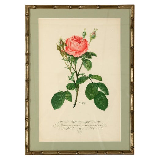
Pierre-Joseph RedoutéRambling Rose by Redoute - Les Roses - Handcoloured engraving - 19th century1828
1828
$388.27List Price
About the Item
- Creator:Pierre-Joseph Redouté (1759 - 1840, French)
- Creation Year:1828
- Dimensions:Height: 9.45 in (24 cm)Width: 6.3 in (16 cm)
- Medium:
- Movement & Style:
- Period:
- Condition:Very good, given age. Remains from binding in the left margin as issued. General age-related toning and/or occasional light stains from handling or foxing. Rear blank. Please study scan carefully.
- Gallery Location:Zeeland, NL
- Reference Number:Seller: 402961stDibs: LU59235060341
Pierre-Joseph Redouté
Pierre-Joseph Redouté (1759-1840), was a painter and botanist originally from Belgium, who pursued his extremely successful artistic career in France. He is well known for his watercolor paintings of roses, lilies and other flowers and their subsequent folio-sized, color stipple engravings. Some believe him to be the greatest botanical illustrator of all time. Redouté was a favorite of the French royal court at the time and of the post French revolution aristocracy. He was an official court artist of Queen Marie Antoinette and his works continued to in demand during and after the French Revolution and Reign of Terror. He combined great artistic skills with a pleasing, ingratiating personality which assisted him with his influential patrons. After the fall of the French monarchy, he was a favorite Empress Joséphine, Napoleon Bonaparte's wife and later by his second wife Marie Louise, Duchess of Parma. The wife of Louis Philippe I, the last king of France, Maria Amalia of Naples and Sicily, was also a patron.
Authenticity Guarantee
In the unlikely event there’s an issue with an item’s authenticity, contact us within 1 year for a full refund. DetailsMoney-Back Guarantee
If your item is not as described, is damaged in transit, or does not arrive, contact us within 7 days for a full refund. Details24-Hour Cancellation
You have a 24-hour grace period in which to reconsider your purchase, with no questions asked.Vetted Professional Sellers
Our world-class sellers must adhere to strict standards for service and quality, maintaining the integrity of our listings.Price-Match Guarantee
If you find that a seller listed the same item for a lower price elsewhere, we’ll match it.Trusted Global Delivery
Our best-in-class carrier network provides specialized shipping options worldwide, including custom delivery.You May Also Like
West Germany: Original Hand Colored 17th Century Map by Johannes Janssonius
By Johannes Janssonius
Located in Alamo, CA
An original hand colored copperplate engraved map entitled in Latin "Archiepiscopatus Maghdeburgensis et Anhaltinus Ducatus cum terris adjacentibus", published in Amsterdam in 1640 i...
Category
Mid-17th Century Old Masters More Prints
Materials
Engraving

Persia & Afghanistan: A Framed Hand-colored 17th Century Map by John Cary
By John Cary
Located in Alamo, CA
This colorful and detailed early 18th century copperplate map by John Cary entitled "A New Map of Persia from the Latest Authorities" was published in London in 1801. It depicts Persia, the region of modern day Afghanistan, the Caspian Sea, the Sea of Aral, the Persian Gulf...
Category
Early 19th Century Old Masters More Prints
Materials
Engraving

$1,175
H 23.5 in W 25.75 in D 1 in
L'Isle de France: A Hand-colored 17th Century Map by De Wit
By Frederick de Wit
Located in Alamo, CA
This colorful and detailed 17th century hand-colored copperplate map by Frederick De Wit was published in Amsterdam between 1666 and 1760. The map depicts the Île-de-France, which is one of the ancient provinces of France. Paris is located in the center of the map, with Versailles to the southwest The map extends from Rouen in the west to Reims in the east. The area around Paris, the Véxin Fran�çais, was the original domain of the king of France. Other areas were ruled by French feudal lords. For example, the Véxin Normand area was the domain of the Duke of Normandy...
Category
Early 18th Century Old Masters More Prints
Materials
Engraving

$1,175
H 28.25 in W 31.25 in D 0.75 in
Cartusia Bruxellensis Monastery in Brussels: A 17th C. Hand-colored Engraving
By Lucas Vorsterman the Younger
Located in Alamo, CA
This is a 17th century hand-colored copperplate engraving entitled "Cartusia Bruxellensis" by Lucas Vorsterman, the Younger, after a drawing by Jacob van Werden or Jacques van Weerden, published in 1659 in Antonius Sanderus' book 'Chorographia sacra Brabantiae sive celebrium aliquot in ea provincia ecclesiarum et coenobiorum descriptio . . . Brussel' (A sacred chorography of Brabant, or a description of several famous churches and convents in that province). It also appeared in other publications by Sanderus. In the 17th century, Brussels was within the Duchy of Brabant.
This engraving depicts a bird's-eye view of the Scheut Carthusian Monastery in Brussels. Scheut is a district of Anderlecht, a municipality of Brussels, Belgium. The monastery housed monks, who took a vow of silence, in 20 rooms. There is a central courtyard with trees and shrubs. Monks are depicted strolling along its pathways. The cells for the friars are in the middle the cloister. There are people along the streets in the foreground and to the right of the large, imposing monastery. Some are on horseback, others are walking. In the lower right, what appears to be a dog pulls a small cart containing barrels, possibly of beer or wine. Districts and neighborhoods are labelled in the background, including Scheut, Anderlecht and Ransfort. A very ornate cartouche in the lower left contains Latin and the artist's attribution. Another decorative cartouche in the upper central area contains the title.
This beautifully hand-colored and detailed engraving is printed on laid, chain-linked paper with wide, full margins. The sheet measures 17.25" high and 21.25" wide. It has Latin text on the verso. It has a central vertical fold, as issued, which is reinforced on the verso. Two small spots in the lower margin may actually represent drops of watercolor paint used to color the engraving. It is otherwise in very good condition.
Antonius Sanderus (1586-1664) was a Flemish Catholic cleric and historian. He was born "Antoon Sanders", but Latinized his name like many writers and scholars of his time. He was the author of several books, including 'Chorographia Sacra Brabantiae', which was illustrated with this engraving.
Lucas Vorsterman the Younger (1624-between 1666 & 1676) was a Flemish Baroque engraver and draughtsman. He produced engravings after the work of contemporary painters and for books by Antwerp publishers.
Jacob van Werden or Jacques van Weerden (active 1643-1669), was a Flemish draughtsman, cartographer, military engineer and archer who was active in the Habsburg Netherlands. His drawings were used as designs for prints executed by various printmakers. He worked on maps, topographical views, historical scenes, portraits and book illustrations. He had a career as a military engineer and a member of the guard of the Spanish King. He advised on various military engineering projects and was an engineer of the Spanish army...
Category
Mid-17th Century Old Masters Landscape Prints
Materials
Engraving

Map of the World: An Original 18th Century Hand-colored Map by E. Bowen
Located in Alamo, CA
This is an original 18th century hand-colored map entitled "A New & Correct Chart of All The Known World Laid down according to Mercator's Projection" by Emanuel Bowen. It was published in 1744 in London in John Harris's "Navigantium atque Itinerantium Bibliotheca" or "A Complete Collection of Voyages and Travels". This highly detailed and colorful map depicts the world. as it was known in the mid 18th century. A majority of the northern and central portions of Canada and America are left blank due to the purity of knowledge at the time this map was published.
The map is embellished with four Compass Roses in the lower left, lower center, lower right and center, along with many rhumb lines. There a is a decorative title cartouche in the upper left. This colorful, attractive, historical and interesting 1744 map presents the entire world on Mercator's projection as it was understood in the middle part of the 18th century, before the landmark explorations of Captain’s Cook, Vancouver, Wilkes and others. It is an example of a nautical chart, a type of map that was designed specifically for use by mariners. The map is centered on the equator and includes both the Eastern and Western Hemispheres. The continents of North America, South America, Europe, Africa, and Asia are depicted, as well as various islands in the Atlantic, Pacific, and Indian Oceans. The map is laid out according to the Mercator projection, a type of cylindrical map projection that was developed in the 16th century by Flemish cartographer Gerardus Mercator. This projection has the advantage of preserving angles and shapes, making it useful for navigation. The map presents a paucity of inland detail, particularly for the Americas, but major cities, geographical landmarks, and regions are included. Ocean currents and Tradewinds are identified, as well as the magnetic declination lines or magnetic variance, which refers to the difference between true north and compass north. The continents are color coded, enhancing the beauty of this map. The three compass roses indicate the directions of the cardinal points.
The depiction of the western coast of America, the Pacific and Australia are interesting. There was very little exploration of Australia between the navigations of William Damper in 1699 and Tobias Furneaux in 1773. Most of the maps detail relies on the 17th century Dutch expeditions to Australia's western coast, by Abel Tasman and William Janszoon. Van Diemen's Land (Tasmania) and New Guinea appear connected to the Australian continent. New Zealand appears as a single landmass. North of New Zealand there is a landmass labelled 'Ter d' St. Esprit' which probably represents the New Hebrides Islands. This map precedes the accurate exploration of the South Pacific and east coast of Australia by Captain James Cook later in the 18th century. The map includes ‘Drakes' Port,' the site where Sir Francis Drake supposedly landed in 1579 during his 1579 circumnavigation of the globe. Here he claimed territory for England, restocked, and repaired his vessels. Drake named the region New Albion. The exact location of Drake's Port is a cartographic mystery. Drake's Harbor is believed to be in the region of San Francisco Bay, Bodega Bay, San Pablo Bay...
Category
Mid-18th Century Old Masters Landscape Prints
Materials
Engraving

$1,275
H 15.75 in W 19.63 in
Map of the East Indies: An Original 18th Century Hand-colored Map by E. Bowen
Located in Alamo, CA
This is an original 18th century hand-colored map entitled "An Accurate Map of the East Indies Exhibiting the Course of the European Trade both on the Continent and Islands" by Emanu...
Category
Mid-18th Century Old Masters Landscape Prints
Materials
Engraving

$1,275
H 15.75 in W 20 in
Siberia as Explored by Behring: Original 18th Century Hand-colored Map by Bowen
Located in Alamo, CA
This is an original 18th century hand-colored map entitled "An Exact Chart of all the Countries through which Capt. Behring Travelled from Tobolski, Capital of Siberia to the Country...
Category
Mid-18th Century Old Masters Landscape Prints
Materials
Engraving

Cadiz Island: A Framed 17th Century Hand-colored Map from Blaeu's Atlas Major
By Joan (Johannes) Blaeu
Located in Alamo, CA
This is a 17th century hand-colored map entitled "Insula Gaditana Isla de Cadiz" from Johannes (Joan) Blaeu's Atlas Maior, published in Amsterdam in 1662.
The map provides an excellent plan of Cadiz Island on the southwest coast of Spain, with its harbor, fortifications, agricultural fields and several surrounding salt processing areas. Numerous sailing ships of various sizes are included in and around the harbor and bay, including five large sailing ships, as well as twenty-four smaller ships. There is a small compass rose overlying the bay. The bridge to the mainland from the island is shown on the right. There is an extremely ornate and colorful title cartouche in the lower left, with its mythological figures reminiscent of Raphael’s Galatea fresco at the Villa Farnesina in Rome. The vibrant colors are vividly preserved. The master colorist tried to emulate a painting by using various tones to create a three-dimensional effect.
Blaeu's name is present in the plate in the lower right. Blaeu stated in his description of Cadiz: “The main wealth of the islanders consists of salt, which they harvest, and
the tuna fisheries.”
This 17th century hand-colored map is framed in an ornate, partially textured bronze-colored wood frame and glazed with UV protected conservation glass. There is a vertical center fold, as issued. There is a faint crease in the lower right and faint color offset on the left from the right side of the map, resulting from having been in an atlas for hundreds of years. Small foci of paint are present in the upper portion of the left margin and in the left corner margin. The map is otherwise in very good condition.
Due in large part to their powerful trade empire, the Dutch became known for cartography in the seventeenth century. This period is considered the Golden Age of Dutch cartography. Their publishing houses produced the highest quality work in Europe, particularly those maps and charts of foreign lands, and Dutch map-making set the bar for cartographic accuracy and artistry into the early-eighteenth century. Some of the most well-known cartographers worked in Amsterdam during this period. Perhaps the most famous of these was the Blaeu family. Willem Janszoon Blaeu, set up shop in Amsterdam. His son, Johannes (Joan), succeeded him upon his death in 1638, continuing in his father’s position as Hydrographer to the Dutch East India Company and selling maps to the public. The Blaeu map presses, located near Amsterdam’s Dam Square...
Category
Mid-17th Century Old Masters Landscape Prints
Materials
Engraving

$1,375
H 20 in W 24.88 in D 1.13 in
Rugen Island, Germany: An Early 17th Century Map by Mercator and Hondius
By Gerard Mercator
Located in Alamo, CA
This is an early 17th century map entitled "Nova Famigerabilis Insulae Ac Ducatus Rugiae Desciptio" (Map of Rugen Island, Germany) by Gerard Mercator and Henricus and Joducus Hondiu...
Category
Early 17th Century Old Masters Landscape Prints
Materials
Engraving

$675
H 18.38 in W 21.75 in
Europe: An Original 18th Century Hand-colored Map by E. Bowen
Located in Alamo, CA
This is an original 18th century hand-colored map entitled "A New & Accurate Map of Europe Drawn from the Best Authorities Assisted by the Most Improved Modern Charts and Maps." by E...
Category
Mid-18th Century Old Masters Landscape Prints
Materials
Engraving

$1,175
H 15.75 in W 19 in
Still Thinking About These?
All Recently ViewedMore Ways To Browse
Antique Miniature Plates
Rambling Rose
Baden Powell
Baldessari Balls In The Air
Banksy Monkey Parliament
Boac Hermes
Brioni Art
Chicken Noodle Soup
Chris Ranes
Colombia Travel Poster
Communist Propaganda Art
Dali Papillon
Dali Satan
Daniel Jensen
Donald Maxwell
Ed Ruscha Turbo Tears
El Al Vintage Poster
Erich Strenger