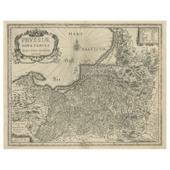
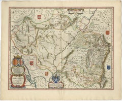
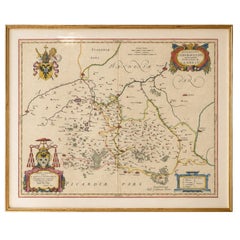
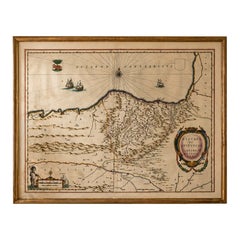
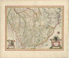
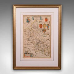
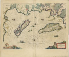
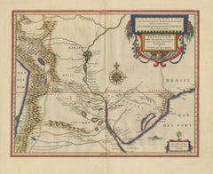
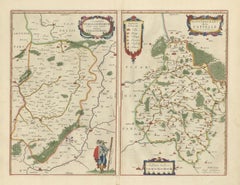
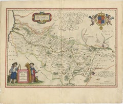
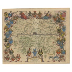
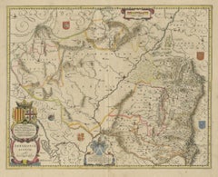
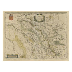
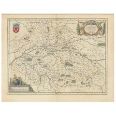
Antique Map of Prussia – Blaeu “Prussiae Nova Tabula”, Later Edition, c.1680
Located in Langweer, NL
Technique: Engraving Maker: Joan Blaeu, Amsterdam, circa 1680
Category
Antique 1680s Maps
Materials
Paper
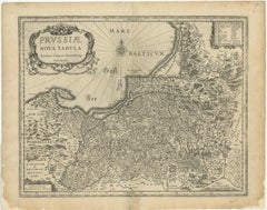
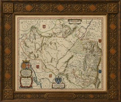
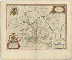
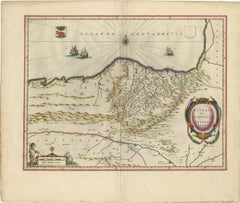
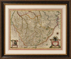
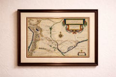
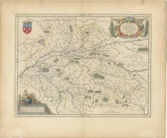
Antique Map of Prussia – Blaeu “Prussiae Nova Tabula”, Later Edition, c.1680
Located in Langweer, NL
Technique: Engraving Maker: Joan Blaeu, Amsterdam, circa 1680
Paper
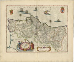
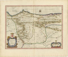
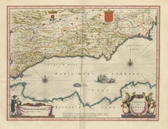
Blaeu Map of Portugal – Portugallia et Algarbia, Antique Iberia Map, 1642
Located in Langweer, NL
Technique: Copperplate engraving with original hand-coloring Maker: Willem & Joan Blaeu, Amsterdam, c.1642
Paper
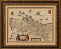
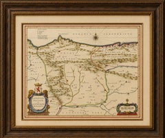
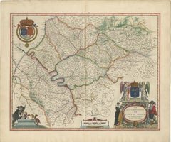
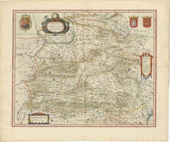
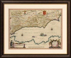
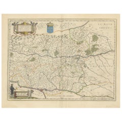
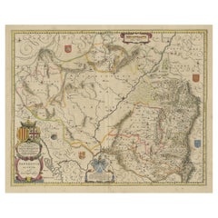
Blaeu Map of Aragon – Arragonia Regnum, Decorative Spain Atlas Map, 1642
Located in Langweer, NL
Blaeu Map of Aragon – Arragonia Regnum, Decorative Spain Atlas Map 1642 A finely engraved and highly decorative map of the historic Kingdom of Aragon in northeastern Spain, publishe...
Paper
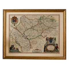
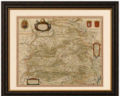
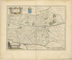
Blaeu Map of León & Asturias – Legionis Regnum, Antique Spain Chart, 1642
Located in Langweer, NL
Blaeu Map of León & Asturias – Legionis Regnum, Antique Spain Chart 1642 A finely engraved and highly decorative map of the historic kingdoms of León and Asturias in northern Spain,...
Paper
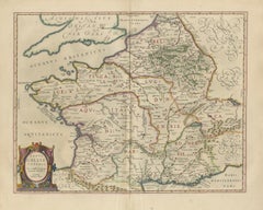
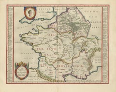
Caesar’s Gallia Veteris – Blaeu Map of Ancient Gaul, France c.1642
Located in Langweer, NL
Technique: Copperplate engraving with original hand-coloring Maker: Willem & Joan Blaeu, Amsterdam, c.1642
Paper
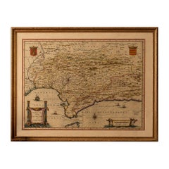
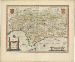
Blaeu Andalusia Map, Seville Cordoba Granada Spain, c.1642
Located in Langweer, NL
Blaeu Andalusia Map, Seville Cordoba Granada Spain, c.1642 Description: A richly engraved and highly decorative map of Andalusia in southern Spain, centered on Seville, Cordoba, and...
Paper
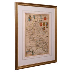
Blaeu Map of Cambrai, Artois & Hainaut – Heraldic France c.1642
Located in Langweer, NL
Technique: Copperplate engraving with original hand-coloring Maker: Willem & Joan Blaeu, Amsterdam, c.1642
Paper
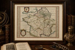
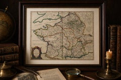
Caesar’s Gallia Antiqua – Blaeu Map of Ancient France, c.1642
Located in Langweer, NL
Caesar’s Gallia Antiqua – Blaeu Map of Ancient France, c.1642 Description: A superb and highly decorative 17th-century map of ancient Gaul, titled Gallia Vetus, published by Willem ...
Paper
$625Sale Price|20% Off
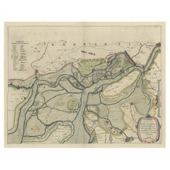
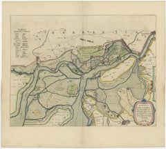
Original Map of the Military Situation After the Dutch Blockade of Antwerp, 1648
Located in Langweer, NL
Artists and Engravers: Joan Blaeu (23 September 1596 - 28 May 1673) was a Dutch cartographer.
Paper
Blaeu Map of Île-de-France – Paris Region with Royal Arms, c.1642
Located in Langweer, NL
Blaeu Map of Île-de-France – Paris Region with Royal Arms, c.1642 Description: A richly detailed and highly decorative 17th-century map of the Île-de-France region, centered on Pari...
Paper
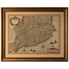
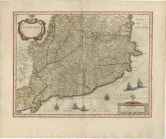
Blaeu Catalonia Map, Barcelona & Mediterranean Coast Spain, c.1642
Located in Langweer, NL
Blaeu Catalonia Map, Barcelona Spain, Mediterranean Sea, c.1642 Description: A superb and highly detailed map of Catalonia, centered on Barcelona and the northeastern regions of Spa...
Paper
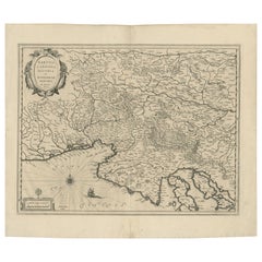
Blaeu Map of Savoy & Alps, Geneva Piedmont France Italy, c.1642
Located in Langweer, NL
Keywords: Savoy map, Alps map, Geneva map, Piedmont map, Blaeu Savoy, 17th century Alps map, Switzerland antique map, northern Italy map, French Alps map, Blaeu atlas map, Lacus Lema...
Paper
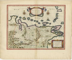
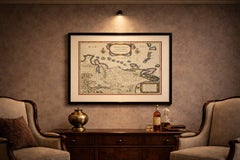
Blaeu Venezuela Map – Decorative Caribbean & Nueva Andalusia Chart 1642
Located in Langweer, NL
Blaeu Venezuela Map – Decorative Caribbean & Nueva Andalusia Chart 1642 A highly decorative and historically important map of Venezuela and the northern coast of South America, publ...
Paper
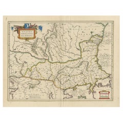
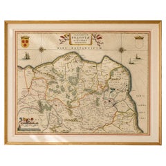
Blaeu Map of Ottoman Balkans – Walachia Bulgaria Romania, circa 1665
Located in Langweer, NL
Blaeu Map of Ottoman Balkans – Walachia Bulgaria Romania, circa 1665 This is an original hand-coloured antique map titled “Walachia, Servia, Bulgaria, Romania,” published by Joan Bl...
Paper
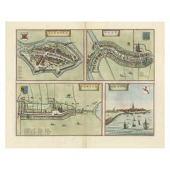
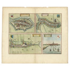
Engravings of the Frisian Cities of Sloten, IJlst, Workum and Hindelopen, c.1650
Located in Langweer, NL
From the town atlas 'Toneel der Steden', published by Joan Blaeu, circa 1650. Artists and Engravers: Joan Blaeu (23 September 1596 - 28 May 1673) was a Dutch cartographer.
Paper
Blaeu Biscay Map, Basque Country Bilbao Cantabria Spain, c.1642
Located in Langweer, NL
Blaeu Biscay Map, Basque Country Bilbao Cantabria Spain, c.1642 Description: A finely engraved and highly decorative map of northern Spain, depicting the historic regions of Biscay,...
Paper
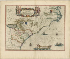
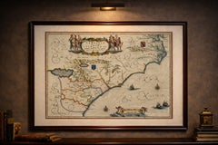
Blaeu Virginia and Florida Map – Decorative Early America Chart, 1642
Located in Langweer, NL
Technique: Copperplate engraving with original hand-coloring Maker: Willem & Joan Blaeu, Amsterdam, c.1642
Paper
Antique Blaeu Map of Sedan & Donchery France, c. 1642 Hand Color
Located in Langweer, NL
Title: Antique Blaeu Map of Sedan & Donchery France, c. 1642 Hand Color Description: A finely engraved and beautifully hand-colored antique map depicting the Sovereignty of Sedan, R...
Paper
Antique Blaeu Map of Champagne France, Campania Comitatus, c. 1642
Located in Langweer, NL
Title: Antique Blaeu Map of Champagne France, Campania Comitatus, c. 1642 Description: A magnificent and highly decorative antique map of the historic Champagne region of France, en...
Paper
Antique Blaeu Map of Castile Spain, Castilla León Madrid Toledo, 1642
Located in Langweer, NL
Produced by Willem and Joan Blaeu during the Dutch Golden Age of cartography, the map originates from the celebrated atlas Toonneel des Aerdrycx, one of the most luxurious and influe...
Paper


Antique Blaeu Map of Beauce & Perche France, c. 1642 Hand Color
Located in Langweer, NL
Title: Antique Blaeu Map of Beauce & Perche France, c. 1642 Hand Color Description: A magnificent and highly decorative antique map depicting the historic French regions of Beauce a...
Paper

Blaeu Map of Boulogne & Calais Coast – Maritime France, Ships c.1642
Located in Langweer, NL
Technique: Copperplate engraving with original hand-coloring Maker: Willem & Joan Blaeu, Amsterdam, c.1642
Paper
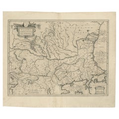
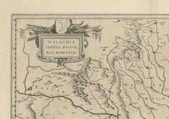
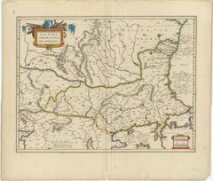
17th Century Blaeu Map – Ottoman Balkans: Walachia, Bulgaria, Romania, ca. 1650
Located in Langweer, NL
Blaeu Map of Walachia, Servia, Bulgaria, Romania, circa 1640 This is an original antique map titled “Walachia, Servia, Bulgaria, Romania,” published by Joan Blaeu in Amsterdam betwe...
Paper
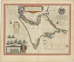
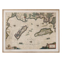
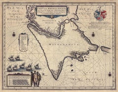
Blaeu Strait of Magellan Map – Tierra del Fuego, Decorative Sea Chart, 1642
Located in Langweer, NL
Blaeu Strait of Magellan Map – Tierra del Fuego, Decorative Sea Chart 1642 A highly important and visually captivating map of the Strait of Magellan and Tierra del Fuego, published ...
Paper
$1,183Sale Price|20% Off
Antique Buckinghamshire Map, English, Framed 17th Century County Cartography
Located in Hele, Devon, GB
An English, framed atlas engraving reproduction by Dutchman Joan Blaeu, dating to the 17th century and later.
Glass, Paper
Blaeu Map of Île de Ré & Oléron, La Rochelle Coast France, c.1642
Located in Langweer, NL
Blaeu Map of Île de Ré & Oléron, La Rochelle Coast France, c.1642 A finely engraved and beautifully composed map of the French Atlantic coast, depicting the islands of Île de Ré, Îl...
Paper
Blaeu Map of Granada & Murcia Spain, Andalusia Mediterranean Coast, 1642
Located in Langweer, NL
Produced during the golden age of Dutch cartography, the map originates from Willem and Joan Blaeu’s celebrated atlas Toonneel des Aerdrycx, one of the most influential and visually ...
Paper
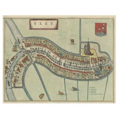

Antique Hand-Colored Map of the Frisian City of IJlst, The Netherlands, 1649
Located in Langweer, NL
In the same year Joan Blaeu also assumed his father?s position as the official cartographer to the V.O.C.
Paper
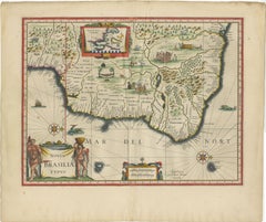
Blaeu Brazil Map, Novus Brasiliae Typus, Antique Hand-Colored Map 1642
Located in Langweer, NL
Blaeu Brazil Map, Novus Brasiliae Typus, Antique Hand-Colored Map 1642 A highly important and visually striking map of Brazil, titled Novus Brasiliae Typus, published by Willem and ...
Paper
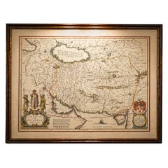
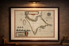
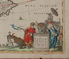
Blaeu Map of Persia, Caspian Sea & Arabia, Hand Colored, c.1642
Located in Langweer, NL
Technique: Copperplate engraving with original hand coloring Maker: Willem & Joan Blaeu, Amsterdam, circa 1642
Paper
Blaeu Paraguay Map, Rio de la Plata, Antique Engraving, South America 1642
Located in Langweer, NL
Blaeu Paraguay Map, Rio de la Plata, Antique Engraving, South America 1642 A highly decorative and historically significant map of Paraguay and the Rio de la Plata region, published...
Paper

$410Sale Price|20% Off
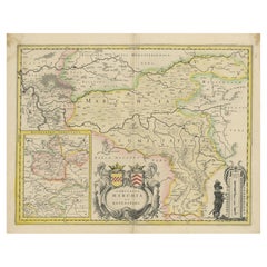
Loudun and Mirebeau: A Cartographic Masterpiece of 17th Century France by Blaeu
Located in Langweer, NL
Willem (1571-1638) and Joan Blaeu (1596-1673), Theatrum Orbis Terrarum sive Atlas Novus..., 1635.
Paper
$1,773Sale Price|20% Off
Large Panoramic View of Thonon-les-Bains near Lake Geneva, France
Located in Langweer, NL
It is further enriched by an elaborate cartouche, a coat of arms, an extensive key and numerous sailing ships on the lake. Published by J. Blaeu, circa 1683. Joan Blaeu was a Dutch ...
Paper
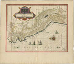
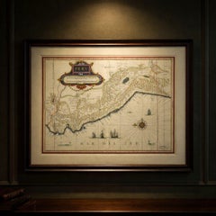
Blaeu Map of Peru, Antique Hand-Colored Engraving, South America 1642
Located in Langweer, NL
Technique: Copperplate engraving with original hand-coloring Maker: Willem & Joan Blaeu, Amsterdam, c.1642
Paper
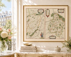
Antique Blaeu Map Vermandois & La Capelle France, Dual Sheet - 1642
Located in Langweer, NL
Keywords: antique map Vermandois, Blaeu Vermandois map, Descriptio Veromanduorum, Gouvernement de la Capelle map, Picardy France map Blaeu, Willem Jansz Blaeu, Joan Blaeu atlas, Toon...
Paper
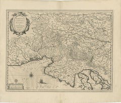
Map of Styria by William Blaeu, 1645: A Masterpiece of 17th-Century Cartography
Located in Langweer, NL
After Willem’s death, his son Joan Blaeu continued the business and expanded its reach.
Paper
Decorative Blaeu Map of Picardy with Costume Figures, France 1642
Located in Langweer, NL
Keywords: antique map Picardy, Blaeu Picardia, Picardia Regio Belgica, Picardie France map, Willem Jansz Blaeu, Joan Blaeu atlas, Toonneel des Aerdrycx, Blaeu 1642 map, Dutch Golden ...
Paper
$448Sale Price|20% Off
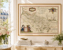
Lyonnais, Beaujolais, Forez, Mâconnais: A 1644 Depiction of France's Provinces
Located in Langweer, NL
The map is made and published by Willem & Joan Blaeu. From: Theatrum Orbis Terrarum.. J. Blaeu, 1644-45.
Paper
$1,307Sale Price|20% Off
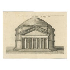
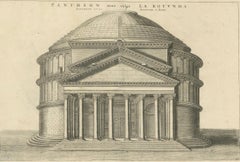
Eternal Echoes Engraved: The Pantheon, Rome's Ancient Marvel, circa 1705
Located in Langweer, NL
Joan Blaeu was a renowned Dutch cartographer born in 1599 and who passed away in 1673.
Paper
$924Sale Price|20% Off
1663 Blaeu's Engraved Map of Frankfurt with Decorative Coats of Arms
Located in Langweer, NL
The Blaeu printing house remained influential until its decline after a devastating fire in 1672 and Joan Blaeu's subsequent death in 1673, with the business ultimately ceasing in 16...
Paper
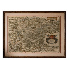
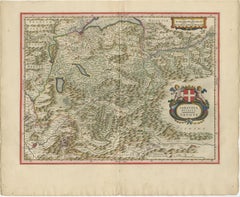
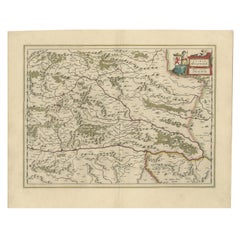
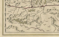
Detailed Antique Map of Northern Spanish Region of Aragon, c.1650
Located in Langweer, NL
In 1635, he released his atlas, Theatrum Orbis Terrarum, sive, Atlas novus. Joan Blaeu (23 September 1596 - 28 May 1673) was a Dutch cartographer.
Paper
Original Antique Blaeu Map of Karst, Carniola, Istria, and Trieste, circa 1640
Located in Langweer, NL
Willem Janszoon Blaeu (1571–1638) was one of the leading Dutch cartographers of the early 17th century, succeeded by his son Joan Blaeu.
Paper
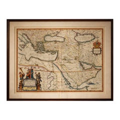
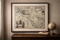
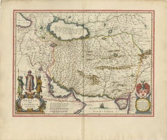
Blaeu Ottoman Empire Map, Turcicum Imperium, Figural Cartouche, 1642
Located in Langweer, NL
Technique: Copper engraving with original hand color Maker: Willem Jansz. Blaeu & Joan Blaeu, Amsterdam, circa 1642 Keywords: Ottoman Empire, Turkey, Constantinople, Istanbul, A...
Paper

$700Sale Price|20% Off
Map of the Duchy Clivia & Ravestein, Brabant in The Netherlands & Germany, 1635
Located in Langweer, NL
From; Theatrum Orbis Terrarum sive Atlas Novus / Volume II, published by Willem and Joan Blaeu from 1635-1655. We do not know the exact date of this map.
Paper

1640 Flandriae Partes Duae Quarum Altera Proprietaria, Ric0016
Located in Norton, MA
1640 Willem and Joan Blaeu map entitled "Flandriae Partes duae quarum altera Proprietaria, altera Imperialis vulgo dictur," Ric0016 (Mounted on Carboard) Willem Janszoon Blaeu...
Paper

Northern Schleswig and Haderslev Map by Johannes Mejer and Johannes Blaeu, 1662
Located in Langweer, NL
Later, these maps were included in a revised edition by Joan Blaeu, one of the leading Dutch cartographers of the 17th century.
Paper
Cartographic Elegance of Touraine: A 17th-Century Map Showing French Heritage
Located in Langweer, NL
"Ducatus Turonensis - Touraine," is a original antique historical map of the Touraine region, which is located in the heart of France, centered around the city of Tours. Created by t...
Paper

$1,850
Persiae, Armeniae, Natoliae et Arabiae Descriptio per Frederick deWit 1666 map
Located in Paonia, CO
Some time after 1674 he acquired the copper plates of town books by Johannes Janssonius and Joan Blaeu. In 1688, he obtained from the States General, the Dutch government of the day,...
Engraving
Tabula Magellanica, qua Tierra del fuego, cum celeberrimis fretis a F. Magellano
By Joan (Johannes) Blaeu
Located in New York, NY
This mid 17th-century map was published by Guiljelmum Blaeu in Amsterdam. The engraved map is 16 1/8 x 21" (41 x 53.1 cm) with beautiful original hand color. Tabula Magellanic...
Engraving
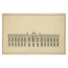
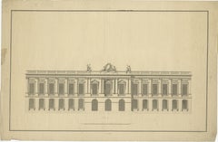
Neoclassical Grandeur: An Architectural Study from the Early 1700s
Located in Langweer, NL
The engraving is possible part of a series published around the early 18th century by Joan Blaeu, a renowned Dutch cartographer born in 1599 and who passed away in 1673.
Paper
$5,508Sale Price|20% Off
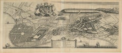
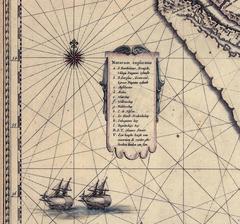
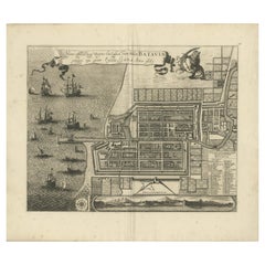
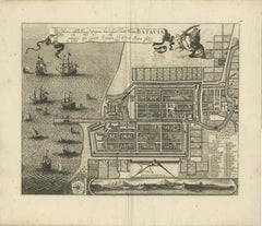
Rare 1681 Map of Batavia: Detailed Dutch Colonial Era Cartography, 1681
Located in Langweer, NL
**Other Possible Engravers**: While Frederick de Wit is a strong candidate, other notable Dutch engravers from that period include Joan Blaeu and Willem Janszoon Blaeu. They also pro...
Paper

Map of Comitatus Marchia et Ravensberg: Historical Counties in Germany, c.1660
Located in Langweer, NL
The map is adorned with an elaborate title cartouche featuring the coats of arms of the two counties and a scale of miles cartouche flanked by a regional figure. Published by J. Blae...
Paper


$448Sale Price|20% Off
Original Antique Map of the Dutch Provinces of Overijssel and Drenthe, 1635
Located in Langweer, NL
Artists and Engravers: Made by 'Joan and Cornelis Blaeu' after an anonymous artist.
Paper
Antique and vintage collectibles and curiosities can bring whimsy and wonder to any interior.
Decorating with old scientific instruments, historical memorabilia and vintage musical instruments, as well as other authentic collectibles and curiosities that can be found on 1stDibs, presents an opportunity to create a unique, natural history museum-like atmosphere in your home that can provoke conversation as often as it pays tribute to how far we’ve come in understanding our world.
And bringing collectibles and curiosities into your space is actually on trend — Wunderkammern, or curiosity cabinets, were all the rage in Europe during the 1500s and continued to have adherents there and in the U.S. in the following centuries. Today, however, they’re experiencing a real surge in popularity and influencing how many interior designers are furnishing and decorating homes — combining contemporary with antique, scientific with tribal, earthly with extraterrestrial, Les Lalanne tables with Flemish tapestries.
The original Wunderkammern were entire rooms filled with objects demonstrating their owners’ worldly knowledge: A proper one included artificiala or preciosa (objets d’art); naturalia (such as skeletons, shells, minerals); exotica (taxidermy or dried plants); and scientifica (scientific instruments), frequently alongside religious relics and ancient artifacts.
Pay tribute to a history of rich and diverse musical traditions that have taken shape all over the world by decorating your home with a collection of antique and vintage musical instruments — with a little help from strong hanging wire or some wall hooks, vintage brass instruments such as a gong, French horn or trumpet can help elevate a home office or complement the efforts you’ve made to ensure a welcoming vibe in your home’s entryway. Bells or antique wind instruments can add provocative metallic contrasts to dark woods as tabletop decorative objects.
Create an intriguing focal point with Georgian scientific instruments, such as stick barometers with mahogany cases or lacquered brass telescopes. These items stem from an era named for the monarchies of the four King Georges, who ruled England in succession starting in 1714 (plus King William’s reign, which lasted until 1837). Just as there was beautiful jewelry produced during the period that today is coveted by collectors, there is much to be found in the collectibles and curiosities realm too.
Wanderlust, nostalgia and a shared love of good design are contributing factors to certain trends in decorating — just as vintage trunks and luggage have reappeared as furniture or home accents in a bedroom or foyer, decorating with globes, maps or nautical objects is similarly rooted in the allure of travel and a penchant for the stylish finishing touch that collectibles bring to our homes.
Find a wide range of antique and vintage collectibles and curiosities on 1stDibs.
It's hard to resist the allure of a beautiful pool. So, go ahead and daydream about whiling away your summer in paradise.
It’s never too early for good design. These interiors combine elevated furnishings and a youthful spirit, resulting in spaces that are at once elegant and whimsical.
Produced in 1843, the well-preserved volume is evidence of the author's exacting specifications.
New or old, the coverlets add old-time charm to any space.
Get into the games! These items celebrate the events, athletes, host countries and sporting spirit.
French trendsetter and serial collector Daniel Rozensztroch tells us about his obsession with objects related to seafaring men.
The sought-after designer worked with the team at Hoffman Creative to produce a monograph that beautifully showcases some of Studio Shamshiri's most inspiring projects.
Italian writer and collector Umberto Pasti opens the doors to his remarkable cave of wonders in North Africa.