By Samuel Chamberlain
Located in Myrtle Beach, SC
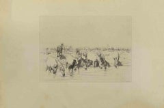
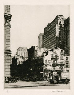
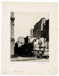
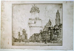
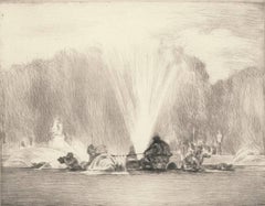
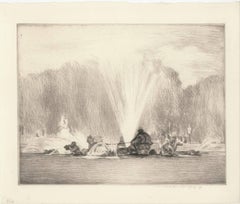
Samuel Chamberlain, 'Manhattan Old and New', drypoint, 1929, edition 100, Chamberlain and Kingsland 81. Signed, titled, and numbered '81/100' in pencil. Titled and annotated '30.00' in pencil, in the artist's hand, bottom margin. Matted to museum standards, unframed.
A superb, finely-detailed impression, with selectively wiped plate tone, on heavy Rives cream wove paper; full margins (1 1/2 to 2 1/4 inches), in excellent condition.
The subject of the print is the lower Manhattan cityscape just before the Depression.
Image size 8 3/4 x 6 13/16 inches (222 x 173 mm); sheet size 12 3/4 x 10 inches (324 x 254 mm).
Impressions of this work are held in the collections of the National Gallery of Art and the Zimmerli Art Museum.
ABOUT THE ARTIST
'There is something about the atmospheric vibrancy of an etching which imparts a peculiar and irresistible life to architectural drawing...A copper plate offers receptive ground to the meticulously detailed drawing which so often appeals to the architect'. —Samuel Chamberlain, from the Catalogue Raisonné of his prints.
Samuel V. Chamberlain (1896 - 1975), printmaker, photographer, author, and teacher, was born in Iowa. His family moved to Aberdeen, Washington in 1901, and in 1913, Chamberlain enrolled in the University of Washington in Seattle, where he studied architecture under Carl Gould. By 1915, he was enrolled in the School of Architecture of the Massachusetts Institute of Technology in Boston. With the United States' involvement in the First World War, Chamberlain sailed to France, where he volunteered in the American Field Service. In 1918, he was transferred to the United States Army to complete his tour of duty. After the war, he returned to Boston and resumed his architectural studies, which he eventually discontinued, working for a few years as a commercial artist.
Chamberlain received the American Field Service Scholarship in 1923, which he used to travel to Spain, North Africa, and Italy. In 1924 he was living in Paris, where he studied lithography with Gaston Dorfinant and etching and drypoint with Edouard Léon, publishing his first etching the following year. In 1927, he studied drypoint with Malcolm Osborne...
Category
1920s American Modern William Woollett Art