
1908 "Map of Texas" by The Kenyon Company
View Similar Items


Video Loading
Want more images or videos?
Request additional images or videos from the seller
1 of 8
1908 "Map of Texas" by The Kenyon Company
About the Item
- Dimensions:Height: 24 in (60.96 cm)Width: 26 in (66.04 cm)Depth: 1.5 in (3.81 cm)
- Materials and Techniques:
- Place of Origin:
- Period:1900-1909
- Date of Manufacture:1908
- Condition:Additions or alterations made to the original: Archival framing by Rio Grande Custom Framing in Boulder, Colorado, in April of 2023. Wear consistent with age and use. Minor fading.
- Seller Location:Colorado Springs, CO
- Reference Number:Seller: M3231stDibs: LU909734130002
About the Seller
4.9
Platinum Seller
Premium sellers with a 4.7+ rating and 24-hour response times
Established in 2010
1stDibs seller since 2011
452 sales on 1stDibs
Typical response time: 1 hour
Authenticity Guarantee
In the unlikely event there’s an issue with an item’s authenticity, contact us within 1 year for a full refund. DetailsMoney-Back Guarantee
If your item is not as described, is damaged in transit, or does not arrive, contact us within 7 days for a full refund. Details24-Hour Cancellation
You have a 24-hour grace period in which to reconsider your purchase, with no questions asked.Vetted Professional Sellers
Our world-class sellers must adhere to strict standards for service and quality, maintaining the integrity of our listings.Price-Match Guarantee
If you find that a seller listed the same item for a lower price elsewhere, we’ll match it.Trusted Global Delivery
Our best-in-class carrier network provides specialized shipping options worldwide, including custom delivery.More From This Seller
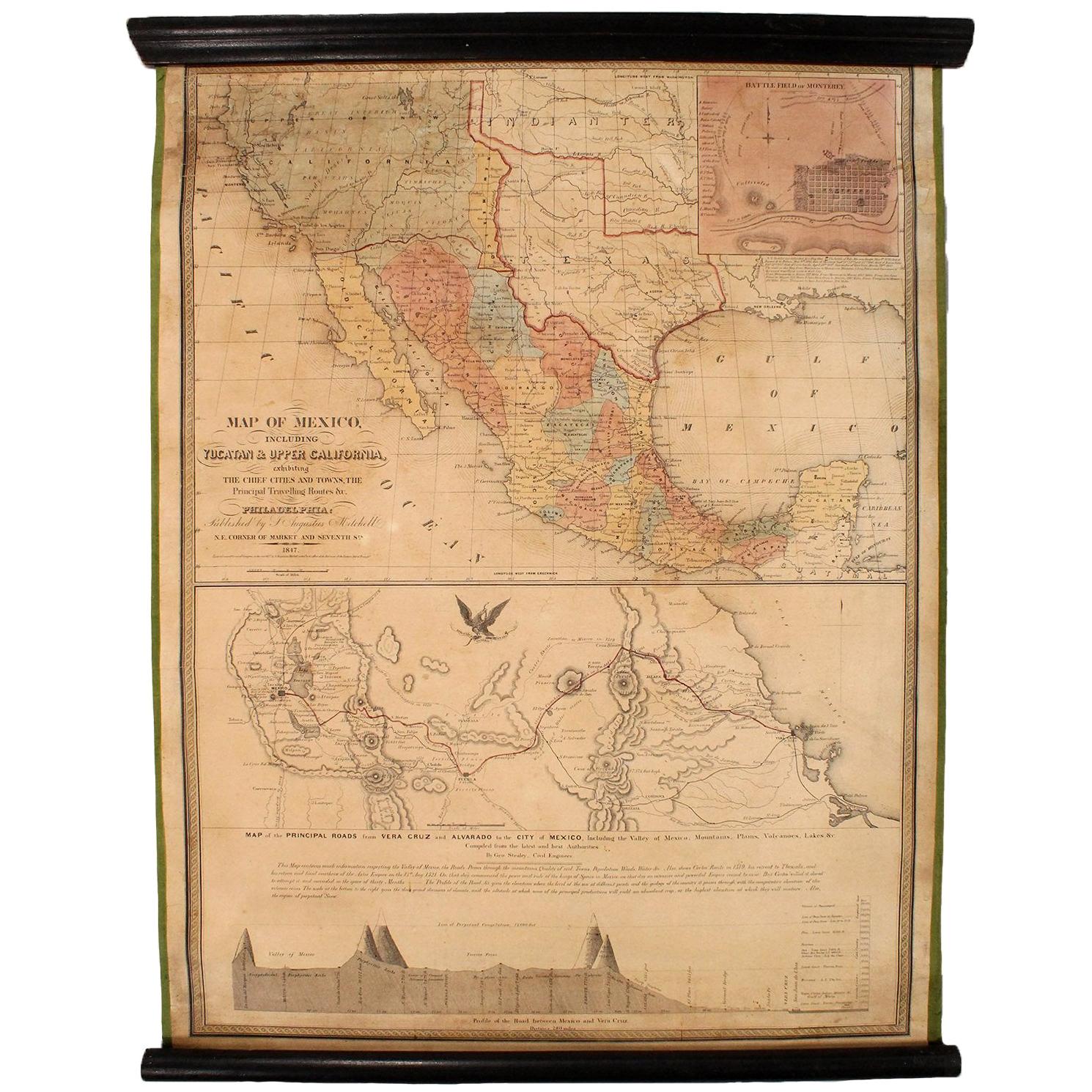
View All1847 Antique Map of Mexico, Texas and California by Samuel Augustus Mitchell
By Samuel Augustus Mitchell 1
Located in Colorado Springs, CO
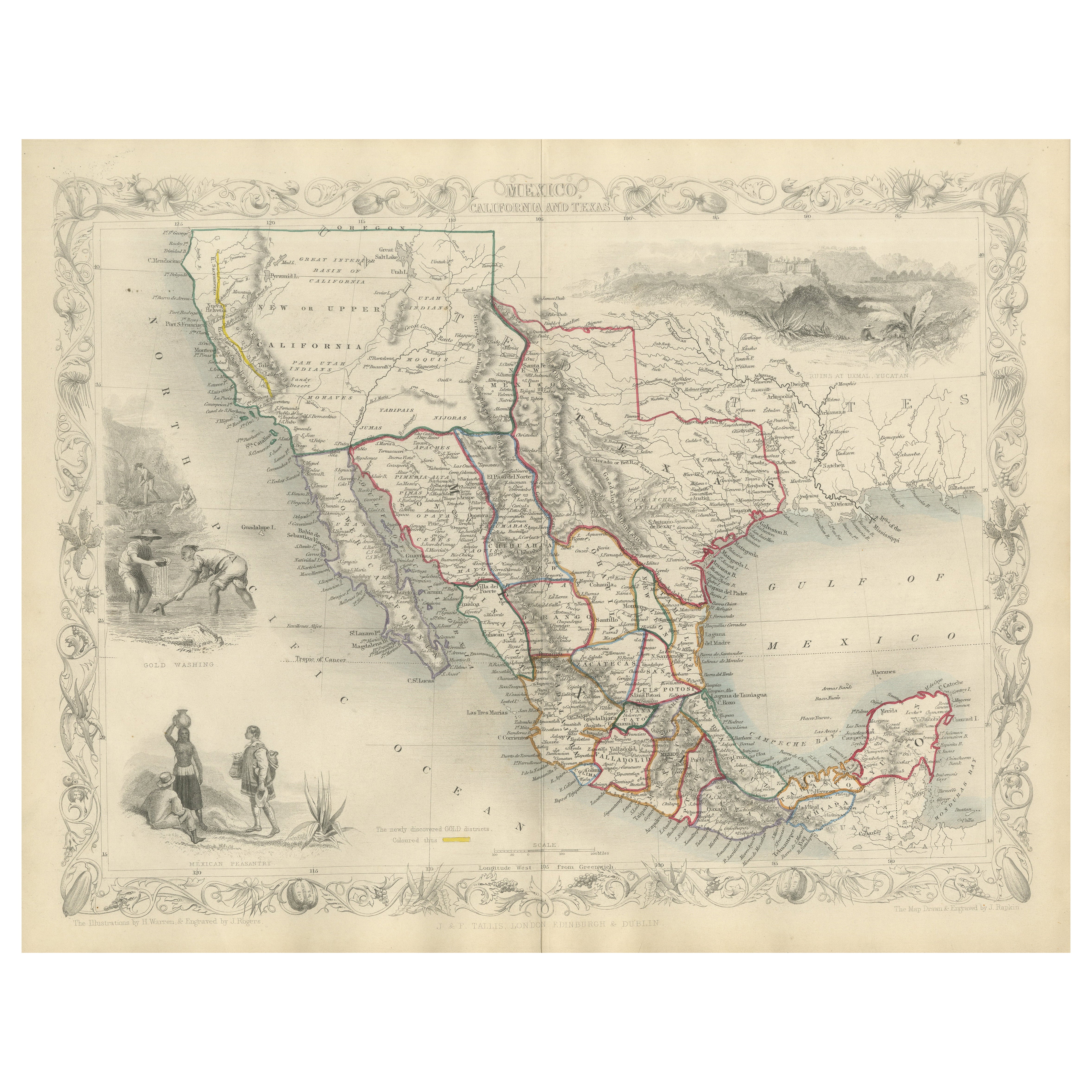
Presented is the second edition of Samuel Augustus Mitchell's Map of Mexico, Including Yucatan & Upper California, an important map showing the progress of the Mexican-American War. ...
Category
Antique 1840s American Maps
Materials
Paper

1859 "Map of the United States of America..." by J. H. Colton
By J.H. Colton
Located in Colorado Springs, CO
Presented is an 1859 “Map of the United States of America, the British Provinces, Mexico, the West Indies and Central America with Part of...
Category
Antique 1850s American Maps
Materials
Paper

1840 Map of the City of Washington Published by William M. Morrison
Located in Colorado Springs, CO
This map, printed in 1840, is a detailed representation of Washington, D.C. in the mid-19th century. The map shows block numbers, wards, and government buildings as well as details o...
Category
Antique 1840s American Federal Maps
Materials
Paper

1939 "A Good-Natured Map of the United States" by Greyhound
Located in Colorado Springs, CO
Presented is an original 1939 map, titled “A Good-Natured Map of the United States Setting Forth the Services of the Greyhound Lines and a Few Principal Connecting Bus Lines.” This brightly colored pictographic map was one of several similar United States maps...
Category
Vintage 1930s American Art Deco Maps
Materials
Paper

1847 Ornamental Map of the United States & Mexico by H. Phelps
Located in Colorado Springs, CO
Offered is an original 1847 ornamental map of the U.S. entitled "Ornamental Map of the United States & Mexico" by Humphrey Phelps. The map was issued as an act of Congress by Phelps on Fulton Street, New York. The broadside is elaborately hand-colored.
This is a very detailed and graphic propaganda map of the United States expressing U.S. dominance of the North American continent. The hand-colored map proclaims the Manifest Destiny, with the recent acquisition of Upper California and Texas at the conclusion of the Mexican-American War. The newly acquired land is boldly colored, standing in stark contrast to the rest of the U.S. The map details a potential route for a railroad running from New York City, to Buffalo, to Chicago, then west along the Oregon Trail to Oregon City. This route anticipates the construction of the transcontinental railroad by nearly 20 years.
The map includes elaborately detailed renderings of George Washington, Hernan Cortez, and Montezuma at top to represent European expansion to the Americas. At bottom are four inset designs with text showing the following: a chronological history of the U.S. beginning from settlement to the U.S. victory in the Mexican-American war; an illustration of General Zachary Taylor with details on the Oregon Territory; an illustration of the Aztec Temple of the Sun in Tenochtitlan and a chronology of the Conquest of the Aztec Empire under Cortez; a portrait of General Antonio Lopez de Santa Anna...
Category
Antique 1840s American Maps
Materials
Paper

1842 Wall Map of the United States by J. H. Young, Published by S. A. Mitchell
Located in Colorado Springs, CO
Presented is an 1842 hanging “Map of the United States,” engraved by J. H. Young and published by Samuel Augustus Mitchell, Philadelphia. This is a beautiful example of the rare 1842...
Category
Antique 1840s American Maps
Materials
Paper

You May Also Like
Antique Map of the Eastern United States with Inset Map of Texas
Located in Langweer, NL
Antique map titled 'Verein-Staaten von Nord-America mit Ausnahme Florida's und der Westlichen Territorien'. This map extends as far west as Louisiana and only includes the northern p...
Category
Antique Mid-19th Century Maps
Materials
Paper

$500 Sale Price
20% Off
Large Antique Map of the State of Texas, 1861
Located in Langweer, NL
Antique map titled 'Johnson's New Map of the State of Texas' Large map of Texas, shows railroads, wagon roads, the U.S. Mail Route, rivers, ports, ...
Category
Antique Mid-19th Century Maps
Materials
Paper
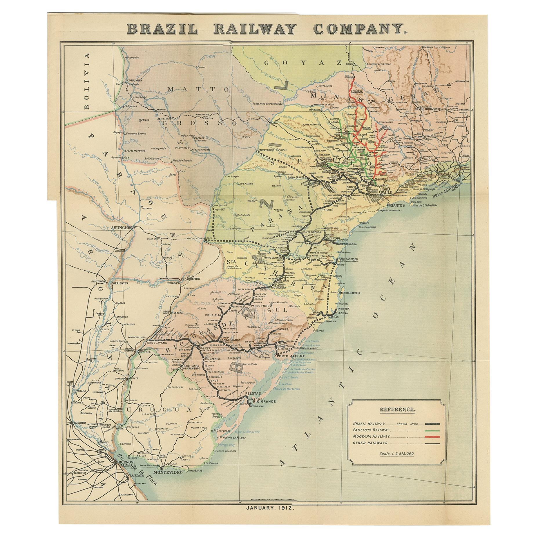
Antique Map of the Brazil Railway Company, '1912'
Located in Langweer, NL
Antique map titled 'Brazil Railway Company'. This folding map is attached to the booklet titled 'The Brazil Railway Company'. It is a memorandum by A. H. A. Knox-Little, who was the ...
Category
Early 20th Century Maps
Materials
Paper

$139 Sale Price
20% Off
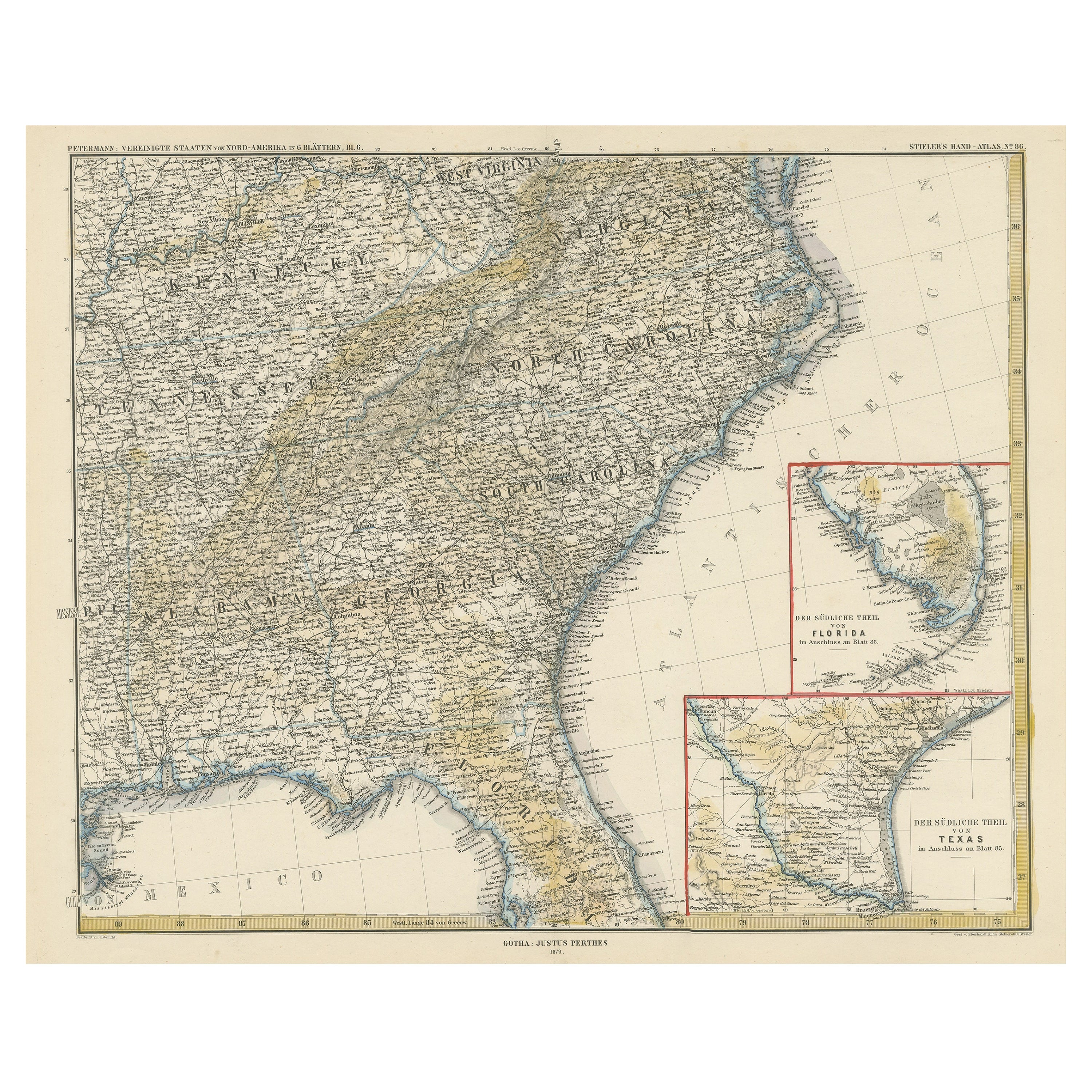
Antique Map of the Region of Georgia with Inset Maps of Florida and Texas
Located in Langweer, NL
Antique map of part of the United States showing Alabama, Georgia, North Carolina, South Carolina, Tennessee, Kentucky, Virginia and part of Florida. With inset maps of the southern ...
Category
Antique Late 19th Century Maps
Materials
Paper
$509 Sale Price
50% Off
1908 The Writings of George Eliot
Located in Bath, GB
A beautifully bound twenty-five volume large paper limited edition of the works of George Eliot, in half crushed morocco bindings, and illustrated throughout.
This set is number 85 ...
Category
Antique Early 1900s American Books
Materials
Paper

1908 The Natural History of Selborne
By Gilbert White
Located in Bath, GB
A beautiful Riviere bound copy of this popular natural history work by ornithologist Gilbert White. An exceptionally bound work, with natural history motifs gilt tooled to the spine....
Category
Antique Early 1900s British Books
Materials
Paper

Recently Viewed
View AllMore Ways To Browse
Blairs Used Furniture
Used Office Furniture Iowa
Antique Furniture Iowa
Texas Poster
Antique Station Of The Cross
2 Toned Bi
Coffee Pot Deco
Collector Spoons
Colorful Bench
Conform Chair
Console Table With Birds
Croatian Artist
Cylindrical Ottoman
Diamond Back Chair
Dining Chairs 8 Traditional
Draped Marble Table
Draw Leaf Table
Drop Leaf Gate Leg Table