Items Similar to Antique Map of the Province of Canada 'East' by A.K. Johnston, 1865


Want more images or videos?
Request additional images or videos from the seller
1 of 5
Antique Map of the Province of Canada 'East' by A.K. Johnston, 1865
About the Item
Antique map titled 'Province of Canada (Eastern Sheet)'. Depicting New Brunswick, Newfoundland, Cape Breton Island, Prince Edward Island, Nova Scotia and more. This map originates from the ‘Royal Atlas of Modern Geography’ by Alexander Keith Johnston. Published by William Blackwood and Sons, Edinburgh and London, 1865.
- Dimensions:Height: 19.1 in (48.5 cm)Width: 24.41 in (62 cm)Depth: 0.02 in (0.5 mm)
- Materials and Techniques:
- Period:
- Date of Manufacture:1865
- Condition:General age-related toning. Please study image carefully.
- Seller Location:Langweer, NL
- Reference Number:
About the Seller
5.0
Platinum Seller
These expertly vetted sellers are 1stDibs' most experienced sellers and are rated highest by our customers.
Established in 2009
1stDibs seller since 2017
1,916 sales on 1stDibs
Typical response time: <1 hour
- ShippingRetrieving quote...Ships From: Langweer, Netherlands
- Return PolicyA return for this item may be initiated within 14 days of delivery.
More From This SellerView All
- Antique Map of Denmark by A.K. Johnston, 1865Located in Langweer, NLAntique map titled 'Denmark and the Duchies Schleswig, Holstein & Lauenburg; Hanover, Brunswick, Mecklenburg, Oldenburg, Anhalt and Lippe'. With an inset map of Iceland, Copenhagen a...Category
Antique Mid-19th Century Maps
MaterialsPaper
- Antique Map of Scotland 'South' by A.K. Johnston, 1865Located in Langweer, NLAntique map titled 'Scotland (Southern Sheet)'. This map originates from the ‘Royal Atlas of Modern Geography’ by Alexander Keith Johnston. Published by William Blackwood and Sons, E...Category
Antique Mid-19th Century Maps
MaterialsPaper
- Antique Map of South Australia by A.K. Johnston, 1865Located in Langweer, NLAntique map titled 'South Australia, New South Wales, Victoria & Queensland'. This map originates from the ‘Royal Atlas of Modern Geography’ by Alexander Keith Johnston. Published by...Category
Antique Mid-19th Century Maps
MaterialsPaper
- Antique Map of Sweden & Norway by A.K. Johnston '1865'Located in Langweer, NLAntique map titled 'Sweden & Norway (Scandinavia)'. With an inset map of Stockholm and environments. This map originates from the ‘Royal Atlas of Modern Geography’ by Alexander Keith...Category
Antique Mid-19th Century Maps
MaterialsPaper
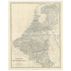
- Antique Map of Belgium and The Netherlands by A.K. Johnston, 1865Located in Langweer, NLAntique map titled 'Belgium and The Netherlands'. This map originates from the ‘Royal Atlas of Modern Geography’ by Alexander Keith Johnston. Published by William Blackwood and Sons,...Category
Antique Mid-19th Century Maps
MaterialsPaper
- Antique Map of England and Wales by A.K. Johnston, 1865Located in Langweer, NLAntique map titled 'England and Wales (Southern Sheet)'. With an inset map of the Scilly Islands. This map originates from the ‘Royal Atlas of Modern Geography’ by Alexander Keith Jo...Category
Antique Mid-19th Century Maps
MaterialsPaper


You May Also Like
- Antique 18th Century Map of the Province of Pensilvania 'Pennsylvania State'Located in Philadelphia, PAA fine antique of the colony of Pennsylvania. Noted at the top of the sheet as a 'Map of the province of Pensilvania'. This undated and anonymous map is thought to be from the Gentleman's Magazine, London, circa 1775, although the general appearance could date it to the 1760's. The southern boundary reflects the Mason-Dixon survey (1768), the western boundary is placed just west of Pittsburgh, and the northern boundary is not marked. The map has a number of reference points that likely refer to companion text and appear to be connected to boundaries. The western and southern boundaries are marked Q, R, S, for example. A diagonal line runs from the Susquehanna R to the Lake Erie P. A broken line marked by many letters A, B, N, O, etc., appears in the east. There are no latitude or longitude markings, blank verso. Framed in a shaped contemporary gilt wooden frame and matted under a cream colored matte. Bearing an old Graham Arader Gallery...Category
Antique 18th Century British American Colonial Maps
MaterialsPaper
- Original Antique Map of Canada, Arrowsmith, 1820Located in St Annes, LancashireGreat map of Canada. Drawn under the direction of Arrowsmith. Copper-plate engraving. Published by Longman, Hurst, Rees, Orme and Brown, 1820 ...Category
Antique 1820s English Maps
MaterialsPaper
- Original Antique Map of South East Asia by Becker, circa 1840Located in St Annes, LancashireGreat map of South East Asia Steel engraving with original color outline Engraved by Becker Published by Virtue, circa 1840. Unframed.Category
Antique 1840s English Other Maps
MaterialsPaper
- Original Antique Map of South East Asia, Arrowsmith, 1820Located in St Annes, LancashireGreat map of South East Asia Drawn under the direction of Arrowsmith Copper-plate engraving Published by Longman, Hurst, Rees, Orme and Brown, 1820 Unframed.Category
Antique 1820s English Maps
MaterialsPaper
- Original Antique English County Map, East Yorkshire, J & C Walker, 1851Located in St Annes, LancashireGreat map of The East Riding of Yorkshire Original colour By J & C Walker Published by Longman, Rees, Orme, Brown & Co. 1851 Unframed.Category
Antique 1850s English Other Maps
MaterialsPaper
- Original Antique Map of The Netherlands, Engraved by Barlow, Dated 1807Located in St Annes, LancashireGreat map of Netherlands Copper-plate engraving by Barlow Published by Brightly & Kinnersly, Bungay, Suffolk. Dated 1807 Unframed.Category
Antique Early 1800s English Maps
MaterialsPaper


Recently Viewed
View AllMore Ways To Browse
Antique Furniture Canada
Antique Canadian Furniture
Canadian Antique Furniture
Canadian Antique
Canada Antiques
19th Century Canadian Furniture
Antique Furniture East London
Brunswick Antique
Antique Breton Furniture
Antique Furniture Brunswick
Map Edinburgh
Antique Map Edinburgh
Antique Map Of Edinburgh
Map Of Antique Province
Antique Province Map
Antique Province Map Of Antique
Canadian Paper 19th
Antique Breton