Items Similar to Antique Map of Spain and Portugal by Petri, c.1873


Want more images or videos?
Request additional images or videos from the seller
1 of 5
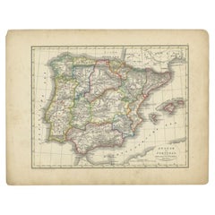
Antique Map of Spain and Portugal by Petri, c.1873
About the Item
Antique map titled 'Spanje en Portugal'. Old map depicting Spain and Portugal. This map originates from 'School-Atlas van alle Deelen der Aarde'. Artists and Engravers: Published by O. Petri, Rotterdam.
Artist: Published by O. Petri, Rotterdam.
Condition: Good, general age-related toning. Split on folding line, please study image carefully.
Date: c.1873
Overall size: 33.1 x 25.9 cm.
Image size: 0.001 x 27.1 x 22.2 cm.
Antique prints have long been appreciated for both their aesthetic and investment value. They were the product of engraved, etched or lithographed plates. These plates were handmade out of wood or metal, which required an incredible level of skill, patience and craftsmanship. Whether you have a house with Victorian furniture or more contemporary decor an old engraving can enhance your living space. We offer a wide range of authentic antique prints for any budget.
- Dimensions:Height: 10.2 in (25.9 cm)Width: 13.04 in (33.1 cm)Depth: 0 in (0.01 mm)
- Materials and Techniques:
- Period:
- Date of Manufacture:circa 1873
- Condition:
- Seller Location:Langweer, NL
- Reference Number:
About the Seller
5.0
Platinum Seller
These expertly vetted sellers are 1stDibs' most experienced sellers and are rated highest by our customers.
Established in 2009
1stDibs seller since 2017
1,938 sales on 1stDibs
Typical response time: <1 hour
- ShippingRetrieving quote...Ships From: Langweer, Netherlands
- Return PolicyA return for this item may be initiated within 14 days of delivery.
More From This SellerView All
- Antique Map of Spain and Portugal by Petri, 1852Located in Langweer, NLAntique map titled 'Spanje en Portugal'. Map of Spain and Portugal. This map originates from 'School-Atlas van alle deelen der Aarde' by Otto Petri. Artists and Engravers: Published ...Category
Antique 19th Century Maps
MaterialsPaper
- Antique Map of Sweden and Norway by Petri, c.1873Located in Langweer, NLAntique map titled 'Zweden en Noorwegen'. Old map depicting Sweden and Norway. This map originates from 'School-Atlas van alle Deelen der Aarde'. Artists and Engravers: Published by ...Category
Antique 19th Century Maps
MaterialsPaper
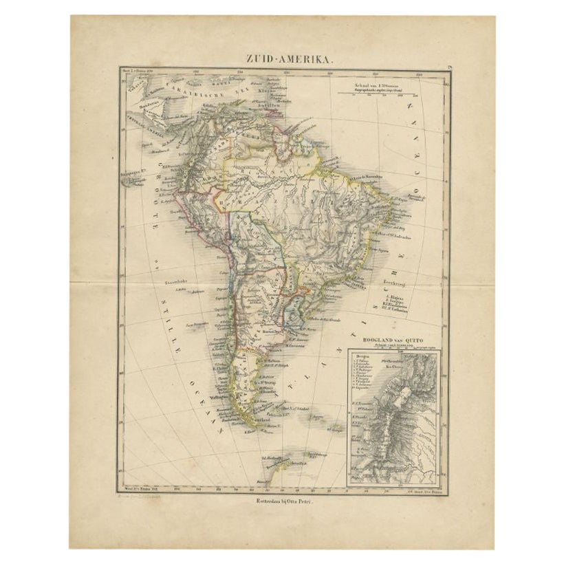
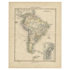
- Antique Map of South America by Petri, c.1873By Thomas KitchinLocated in Langweer, NLAntique map titled 'Zuid-Amerika'. Old map depicting South America, with an inset map of the highland of Quito. This map originates from 'School-Atlas van alle Deelen der Aarde'. Art...Category
Antique 19th Century Maps
MaterialsPaper
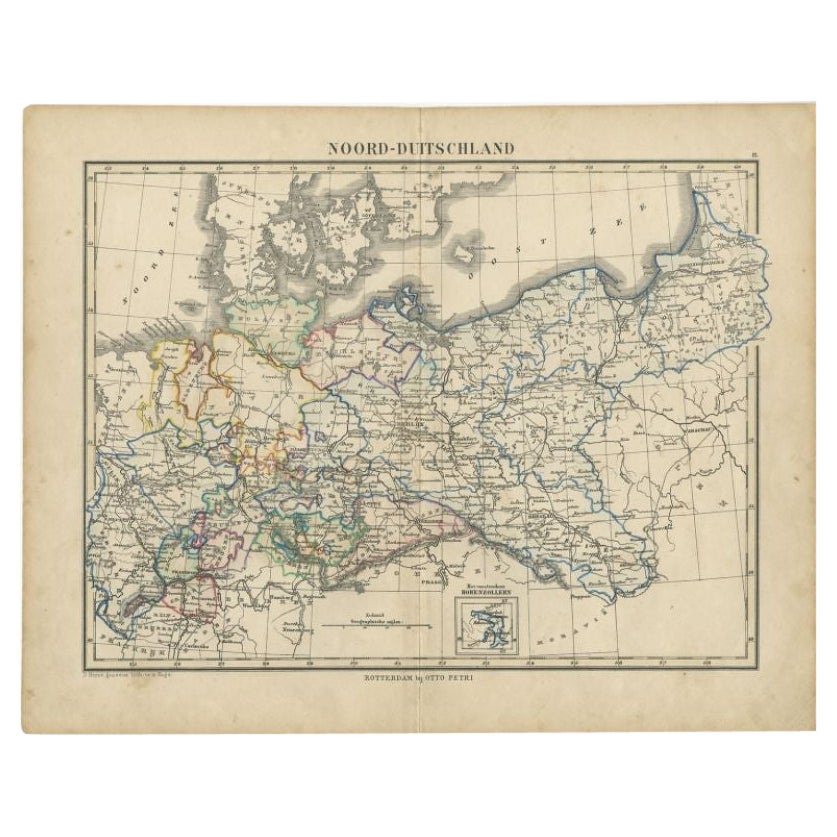
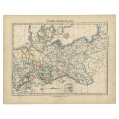
- Antique Map of Northern Germany by Petri, c.1873Located in Langweer, NLAntique map titled 'Noord-Duitschland'. Old map depicting northern Germany. This map originates from 'School-Atlas van alle Deelen der Aarde'. Artists and Engravers: Published by O. ...Category
Antique 19th Century Maps
MaterialsPaper
- Antique Map of Turkey and Greece by Petri, c.1873Located in Langweer, NLAntique map titled 'Europisch Turkije en Griekenland'. Old map depicting Turkey in Europe and Greece. This map originates from 'School-Atlas van alle Deelen der Aarde'. Artists and...Category
Antique 19th Century Maps
MaterialsPaper
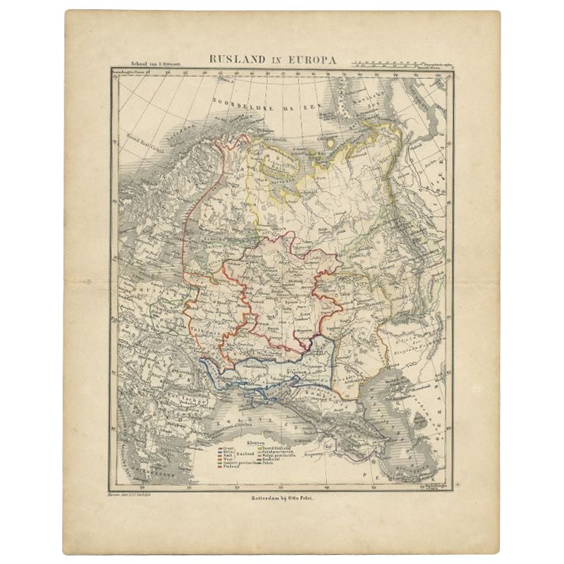
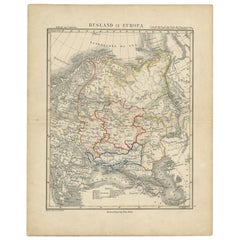
- Antique Map of Russia in Europe by Petri, c.1873Located in Langweer, NLAntique map titled 'Rusland in Europa'. Old map depicting Russia in Europe. This map originates from 'School-Atlas van alle Deelen der Aarde'. Artists and Engravers: Published by O. ...Category
Antique 19th Century Maps
MaterialsPaper


You May Also Like
- Original Antique Map of Spain and Portugal, circa 1790Located in St Annes, LancashireSuper map of Spain and Portugal Copper plate engraving by A. Bell Published, circa 1790. Unframed.Category
Antique 1790s English Other Maps
MaterialsPaper
- Original Antique Map of Spain and Portugal, Engraved By Barlow, 1806Located in St Annes, LancashireGreat map of Spain And Portugal Copper-plate engraving by Barlow Published by Brightly & Kinnersly, Bungay, Suffolk. 1806 Unframed.Category
Antique Early 1800s English Maps
MaterialsPaper
- 18th Century Hand Colored Map of Spain and Portugal by VisscherBy Nicolaes Visscher IILocated in Alamo, CAThis is an early 18th century map of Spain and Portugal, with attractive original hand-coloring, entitled "Hispaniae et Portugalliae Regna per Nicolaum Visscher cum Privilegio Ordinu...Category
Antique Early 18th Century Dutch Maps
MaterialsPaper
- 1873 "Map of the States of California and Nevada" by Chas. Drayton GibbesLocated in Colorado Springs, COPresented is Warren Holt and Charles Drayton Gibbes' 1873 “Map of California and Nevada.” This map is considered to be one of the finest large-scale ...Category
Antique 1870s American Maps
MaterialsPaper
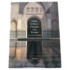
- Garden of Morocco, Spain and Portugal Hardcover Book French Ed.Located in North Hollywood, CAGarden of Morocco, Spain and Portugal Hardcover Book French Ed.Jardins du Maroc, d'Espagne et du Portugal : Un art de vivre partagé.French Edition by Mohammed El Faïz (Author), Manu...Category
21st Century and Contemporary Moroccan Moorish Books
MaterialsPaper
- 1861 Topographical Map of the District of Columbia, by Boschke, Antique MapLocated in Colorado Springs, COPresented is an original map of Albert Boschke's extremely sought-after "Topographical Map of the District of Columbia Surveyed in the Years 1856 ...Category
Antique 1860s American Historical Memorabilia
MaterialsPaper


Recently Viewed
View AllMore Ways To Browse
Spanish Furniture And Decor
Spanish Antiques Metal
Antique Spanish Plates
Antique Map Spain
Antique Maps Spain
Antique Spain Map
Spain Antique Map
Antique Maps Of Spain
Antique Map Of Spain
Antique School Map
Antique School Maps
Spanish Decor Antique
Portugal Map
Map Of Portugal
Antique Map Of Portugal
Antique Map Portugal
Antique Portuguese Plates
Old School Maps