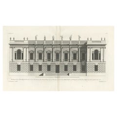
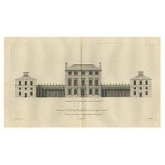
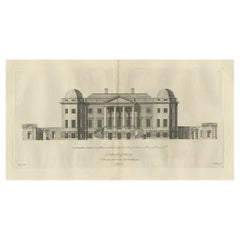
Old Engraving of Burlington House, Piccadilly in Mayfair, London, England, 1725
View Similar Items


Want more images or videos?
Request additional images or videos from the seller
1 of 6
Auction endedBrowse Current Auctions
Old Engraving of Burlington House, Piccadilly in Mayfair, London, England, 1725
About the Item
- Dimensions:Height: 19.89 in (50.5 cm)Width: 25.99 in (66 cm)Depth: 0 in (0.02 mm)
- Materials and Techniques:Paper,Engraved
- Period:1720-1729
- Date of Manufacture:1725
- Condition:Condition: Good, age-related toning. Blank verso. Minor wear, please study image carefully.
- Seller Location:Langweer, NL
- Reference Number:Seller: BG-12208-339 1stDibs: LU3054326716572
About the Seller
5.0
Platinum Seller
These expertly vetted sellers are 1stDibs' most experienced sellers and are rated highest by our customers.
Established in 2009
1stDibs seller since 2017
1,948 sales on 1stDibs
More From This SellerView All
- Antique Print of Designs for Pembroke House Whitehall, London, England, 1725Located in Langweer, NLAntique print titled 'Elevation of the Right Honourable the Lord Herbert (..)'. Designs for Pembroke House, front elevation and plans of the principal storey and the attic storey o...Category
Antique 18th Century Prints
MaterialsPaper
- Old Engraving of Chesterfield House, Westminster in London, Uk, ca.1770Located in Langweer, NLTitle: Antique print titled 'Elevation of the R. Hoble Earl of Chesterfields House (..)'. Old engraving of Chesterfield House, Westminster. It was a ...Category
Antique 1770s Prints
MaterialsPaper
 $483 Sale Price20% Off
 - Old Engraving of Foremarke Hall, a Manor House in Derbyshire, England, ca.1770Located in Langweer, NLDescription: Antique print titled 'North Front of Foremark (..)'. Old engraving of Foremarke Hall, a Georgian-Palladian country house and manor house. This print originates from ...Category
Antique 1770s Prints
MaterialsPaper
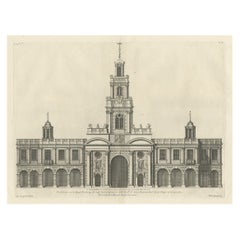
- Engraving of the Entrance Facade of the Royal Exchange, Cornhill, London, 1725Located in Langweer, NLAntique print titled 'The Elevation of the Royal Exchange (..)'. Old engraving of the entrance facade of the Royal Exchange, Cornhill. This print originates from 'Vitruvius Brita...Category
Antique 1720s Architectural Models
MaterialsPaper
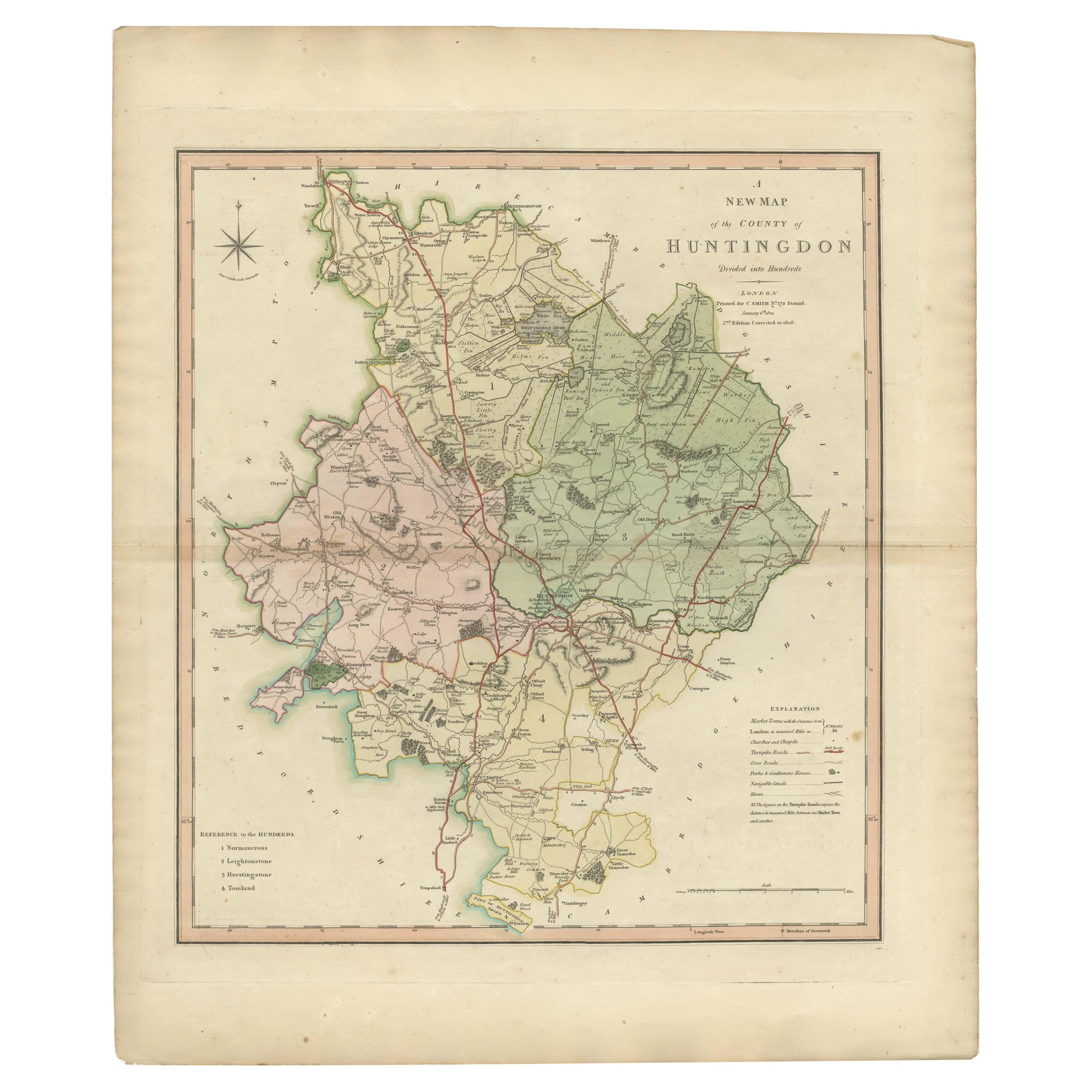
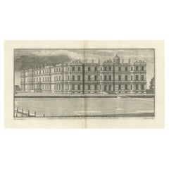
- Antique Print of Longleat in Wiltshire, England, 1725Located in Langweer, NLAntique print titled 'Long Leate in Wiltshire (..)'. Old engraving of Longleat, Wiltshire. Longleat is an English stately home and the seat of the Marquesses of Bath. It is a lea...Category
Antique 18th Century Prints
MaterialsPaper
- Old Engraving the City and Harbour of Pathmos, Patmos or Patimo in Greece, 1725Located in Langweer, NLAntique print, titled: 'Gezicht van het eiland en de haven van Pathmos (…).' This plate shows a view of the city and harbour of Pathmos, Patmos or Patimo in Greece. This plate or...Category
Antique 1720s Maps
MaterialsPaper
 $817 Sale Price20% Off
You May Also Like
- Old Horizontal Map of EnglandBy TassoLocated in Alessandria, PiemonteST/520 - Old rare Italian map of England, dated 1826-1827 - by Girolamo Tasso, editor in Venise, for the atlas of M.r Le-Sage.Category
Antique Early 19th Century Italian Other Prints
MaterialsPaper
 $237 Sale Price20% Off
 - “A Football Match, Scotland v. England” Antique Engraving, Proof Edition of 100By Overend and SmytheLocated in Colorado Springs, COThis is the 1889 William H. Overend (1851-1898) and Lionel Smythe (1839-1918) first edition, photogravure of the Calcutta Cup – a Rugby match between Scotland and England, that has been played over 100 times, the first match...Category
Antique 19th Century English Prints
MaterialsPaper
- “The Restaurant of the House of Representatives” Engraving by Harper's WeeklyLocated in Colorado Springs, COThis original wood engraving is titled “The Restaurant of the House of Representatives, Washington, DC.” It was published as a double-page image, in the August 12, 1893 issue of the famous 19th century newspaper Harper’s Weekly. The print was illustrated by Charles Stanley Reinhardt. The House Restaurant, a unique part of life in the Capitol, has been in the same location since the 1857 Capitol Expansion. Congressional members’ busy work schedule made the availability of food on site a necessity. But the restaurant also served as an informal meeting spot for members to continue conversations and deal making. This 1893 print illustrates the convivial atmosphere. Details including elegantly dressed tables...Category
Antique 1890s American Prints
MaterialsPaper
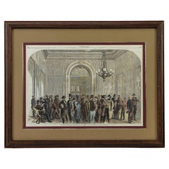
- “House of Representatives & Civil Rights Bill” Wood Engraving by Harpers WeeklyLocated in Colorado Springs, COThis original wood engraving is titled “The Lobby of the House of Representatives at Washington During the Passage of the Civil Rights Bill.” ...Category
Antique 1860s Prints
MaterialsPaper
- Old Nautical Map of CorsicaLocated in Alessandria, PiemonteST/556/1 - Old map of Corsica isle, surveyed by Captain Hell, of the French Royal Navy in 1824, engraved and published on 1874, with additions and corre...Category
Antique Early 19th Century English Other Prints
MaterialsPaper
 $351 Sale Price20% Off
 - 1876 "Gettysburg, The Repulse of Longstreet's Assault." EngravingLocated in Colorado Springs, COPresented here is an 1876 engraving of John B. Bachelder and James Walker’s Gettysburg. The Repulse of Longstreet’s Assault. The engraved scene depicts the decisive battle on the final day of the Battle of Gettysburg. Researched by the photographer and topographer John B. Bachelder and painted by James Walker, the original painting was created in 1870. This detailed engraving was done by H. B. Hall Jr. and published by James Drummond Ball. Otherwise called Pickett’s Charge, the battle occurred on July 3, 1863. Pickett’s corp commander, Lieutenant General James Longstreet was placed in charge of the attack despite his hesitations. Longstreet’s central role led to the title of the work, Repulse of Longstreet’s Assault. In an attempt to gain control of an important supply route, nine Confederate brigades charged across three-quarters of a mile of open ground against cannon fire to take Cemetery Ridge from the defending Union Army. Despite their overwhelming numbers, the Confederate forces were repelled with considerable casualties marking not only a decisive victory for the Union, but also the beginning of the slow defeat of Lee’s Army. The furthest the charging forces advanced before being repulsed would forever be known as the “High Water Mark of the Confederacy.” The Confederate army never recovered from the losses at Gettysburg and it effectively ended Lee’s campaign into Pennsylvania. The engraving gives the perspective from the Union rear, one that encompasses most of the battlefield, from Big Round Top on the left to the northern reaches of Cemetery Ridge on the right. The Confederate lines at Seminary Ridge are in the far distance, partially obscured by bursting shells. The image centers on the main Confederate assault, in the vicinity of what today are known as "The Copse" and "The Bloody Angle." The composition has elemen...Category
Antique 1870s American Prints
MaterialsPaper


Recently Viewed
View AllMore Ways To Browse
Architectural Studies
Architectural Study
London England
Antique Furniture In London
Antique London England
Antique Furniture London England
Old England
House Model
In Old England
Model Of House
English Country House
London Images
House Plan
Architectural Model House
Antique English Models
London England Engraving
Architecture Building Model
Antique English Architectural