1857 Antique Coltons General Atlas World State Country Map Description Book
View Similar Items

Want more images or videos?
Request additional images or videos from the seller
1 of 13
1857 Antique Coltons General Atlas World State Country Map Description Book
About the Item
- Dimensions:Height: 17.75 in (45.09 cm)Width: 15 in (38.1 cm)Depth: 2 in (5.08 cm)
- Style:Victorian (Of the Period)
- Materials and Techniques:
- Period:
- Date of Manufacture:1857
- Condition:Wear consistent with age and use. Good overall, wear and distressing commensurate with age and use, edge and corner wear, creasing, foxing, cover detaching.
- Seller Location:Dayton, OH
- Reference Number:Seller: 317291stDibs: LU5343225620862

About the Seller
5.0
Platinum Seller
Premium sellers with a 4.7+ rating and 24-hour response times
Established in 2010
1stDibs seller since 2020
1,554 sales on 1stDibs
Authenticity Guarantee
In the unlikely event there’s an issue with an item’s authenticity, contact us within 1 year for a full refund. DetailsMoney-Back Guarantee
If your item is not as described, is damaged in transit, or does not arrive, contact us within 7 days for a full refund. Details24-Hour Cancellation
You have a 24-hour grace period in which to reconsider your purchase, with no questions asked.Vetted Professional Sellers
Our world-class sellers must adhere to strict standards for service and quality, maintaining the integrity of our listings.Price-Match Guarantee
If you find that a seller listed the same item for a lower price elsewhere, we’ll match it.Trusted Global Delivery
Our best-in-class carrier network provides specialized shipping options worldwide, including custom delivery.More From This Seller
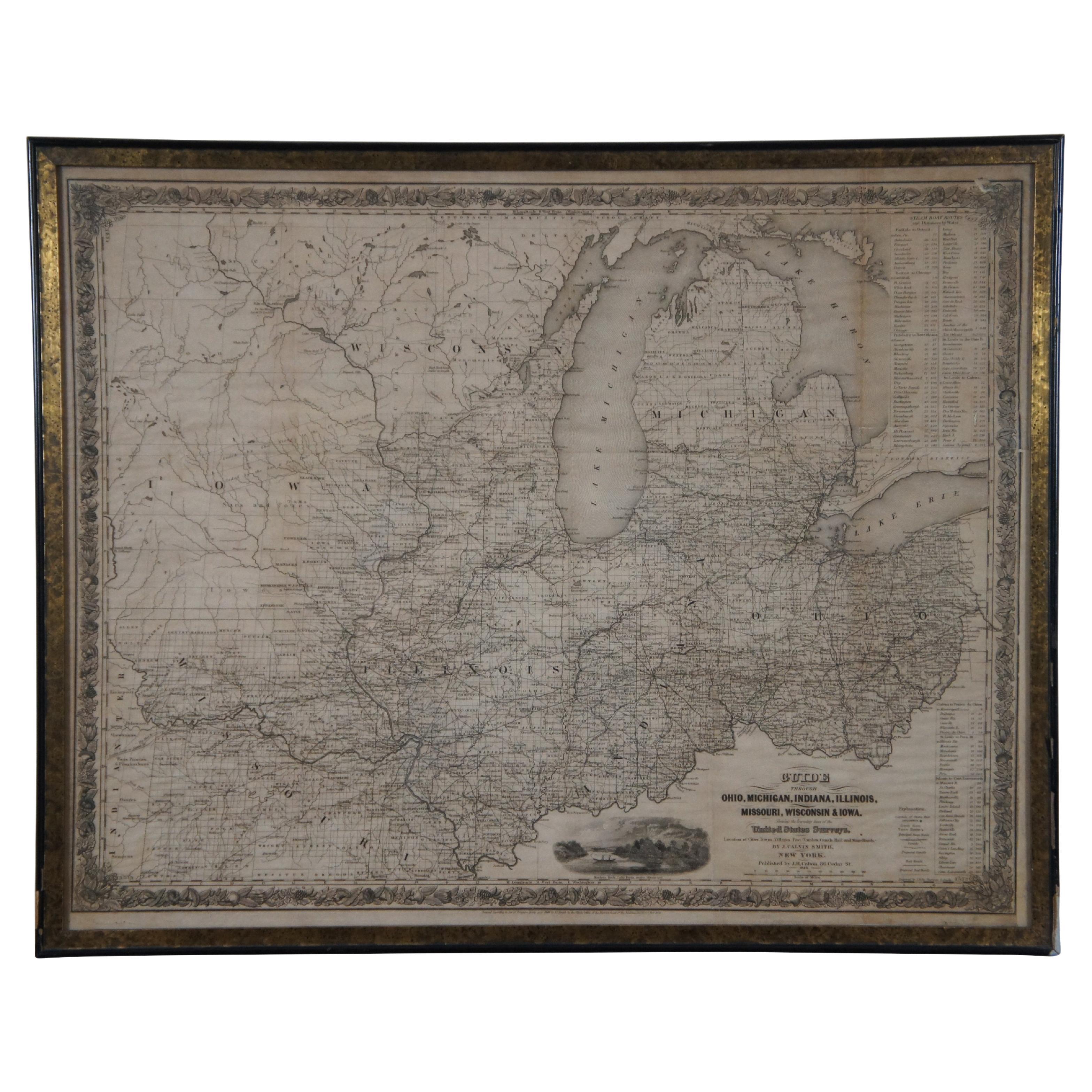
View AllAntique 1844 J Calvin Smith JH Colton Midwest United States Survey Map 27"
By J.H. Colton
Located in Dayton, OH
Antique framed black and white map of seven Midwestern American states. Guide Through Ohio, Michigan, Indiana, Illinois, Missouri, Wisco...
Category
Antique 1840s Maps
Materials
Paper

$940 Sale Price
20% Off
Vincenzo Coronelli's Colored Map of the New World Western Hemisphere Framed 47"
By Vincenzo Coronelli
Located in Dayton, OH
A Framed Reproduction of Coronelli's Map of the New World, Attributed to Trevor James Company. The map shows the Western Hemisphere including the discoveries made by Abel Tasman in A...
Category
20th Century Maps
Materials
Paper

$1,080 Sale Price
20% Off
Antique Chicago Illinois National Map Commercial Rollup Classroom Census Map 47"
Located in Dayton, OH
Antique early to mid 20th century double sided hanging map titled the New Commercial and Census Map of Illinois, Edition 1073. Verso shows the National Map of Chicago and Suburbs - O...
Category
Early 20th Century North American Maps
Materials
Paper

$940 Sale Price
20% Off
Large Antique GE General Electric Oscillating Industrial Desk Fan Works 21"
By General Electric
Located in Dayton, OH
Large antique 1915 2-Star / Loop handle desk fan by General Electric. Black painted steel housing with four brass blades / wings and cage with serpentine bars. Three speed; oscillati...
Category
Vintage 1910s Industrial Scientific Instruments
Materials
Brass, Steel
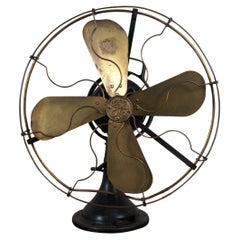
$640 Sale Price
20% Off
20th Century Large Vintage Oval Wall Map of the World Globe Conference Table 13'
Located in Dayton, OH
Monumental oval classroom map of the world / wall globe from the second half of the 20th century. A two piece sculpture design made with heavy wood and metal trim paneling. Can be ...
Category
20th Century Maps
Materials
Metal

$2,400 Sale Price
20% Off
Antique Colored Belgium Map Flandria Gallica Flanders Henricus Hondius
Located in Dayton, OH
Antique hand colored map of Flanders, Belgium, engraved by Henricus Hondius.
Sans frame - 21.25” x 18”.
Category
Antique 19th Century Renaissance Maps
Materials
Paper

$280 Sale Price
20% Off
You May Also Like
Antique Map Colton's United States of America
Located in Langweer, NL
Antique map titled 'Colton's United States of America'. Show railroads, canals, state capitals, major cities and towns, military posts, historic trails, Pony Express and U.S. mail routes; Dakota [Territory] extending deep into Nebraska, and Idaho [Territory] encompassing [modern day] Montana and Wyoming; Indian Territory...
Category
Antique Mid-19th Century Maps
Materials
Paper

$824 Sale Price
20% Off
Antique North America Map, USA, Canada, Mexico, Cartography, Colton, Victorian
Located in Hele, Devon, GB
This is an antique North America map. A USA, framed lithography atlas engraving of the continent by JH Colton, dating to the Victorian period and later, circa 1860.
Fascinating, large framed map...
Category
Antique Mid-19th Century American Victorian Maps
Materials
Paper

Antique Andrees Handatlas, German Cartography Book, Maps, Atlas, Reference, 1924
Located in Hele, Devon, GB
This is a large volume antique copy of Andrees' Handatlas. A German, bound chromolithography atlas, dating to the early 20th century, this edition published in 1924.
Full title: And...
Category
Vintage 1920s German Other Books
Materials
Paper

1816 Large Southern Hindostan Map by J. Thomson – New General Atlas
Located in Langweer, NL
Title: 1816 Southern Hindostan Map by J. Thomson – New General Atlas
This map, titled "Southern Hindostan," was published in 1816 as part of J. Thomson’s *New General Atlas*. The ma...
Category
Antique 1810s Maps
Materials
Paper
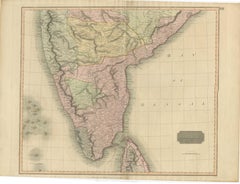
$490 Sale Price
20% Off
1817 Large Northern Hindostan Map by J. Thomson – New General Atlas
Located in Langweer, NL
1817 Thomson Map of Northern Hindoostan – Detailed British Cartography of India
This map, titled "A New Map of Hindoostan from the Latest Authorities," was drawn and engraved for Jo...
Category
Antique 1810s Maps
Materials
Paper
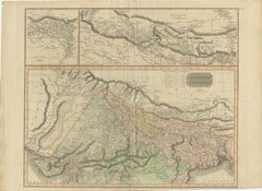
$490 Sale Price
20% Off
Ancient World Map: Europe, Africa & Asia - 1802 Tardieu Atlas
Located in Langweer, NL
Antique Map Description with title: "Monde Connu Des Anciens"
Publication Details:
- Atlas Title: Nouvel Atlas Universel de Géographie Ancienne et Moderne
- Purpose: For the Nouvel...
Category
Antique Early 1800s Maps
Materials
Paper
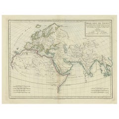
$407 Sale Price
20% Off
Recently Viewed
View AllMore Ways To Browse
Fisher Antique
Antique Furniture Kansas City
Antique Civil War Maps
Antique Maps Of Kansas
Utah Map
Agricultural Americana
Michel Arnaud
Otobong Nkanga
P Buckley Moss
Patricia Kluge
Rockwell Kent Moby Dick
Sanford Biggers
Savoy Cocktail Book 1930
Savoy Cocktail Book
Sheridan Memoirs
Sidney Paget
Steve Mcqueen Jacket
Stonehouse Furniture