Items Similar to 1763 Batavia: A Detailed Bird's-Eye View of Jakarta in the Dutch Colonial Era
Want more images or videos?
Request additional images or videos from the seller
1 of 6
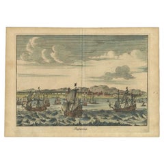
1763 Batavia: A Detailed Bird's-Eye View of Jakarta in the Dutch Colonial Era
About the Item
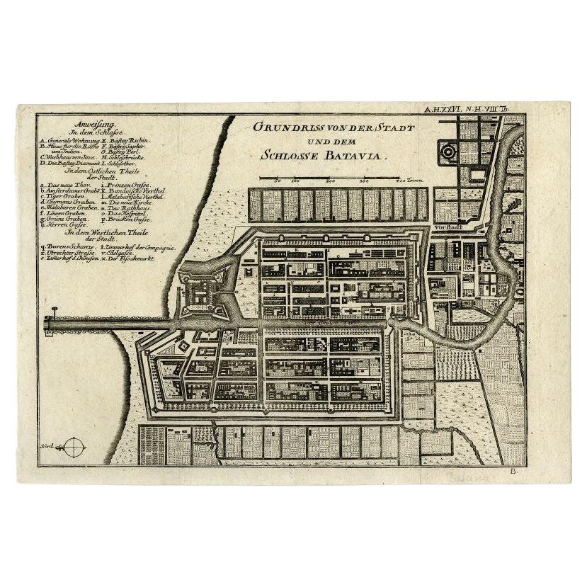
This is a bird's-eye view plan of Batavia, the historical name for Jakarta, Indonesia, dating back to 1763.
The map was crafted by J van der Schley / P de Hondt and is a fine example of cartographic detail and artistry from the 18th century. It depicts the city's layout and fortifications with precision, offering insight into the urban design and colonial fortifications of the time. The map is hand-colored and showcases the geographical features and man-made structures with clear demarcations. The streets, buildings, and city walls are illustrated from an elevated perspective, providing a comprehensive overview of Batavia as it existed in the mid-1700s, during the period when it was a bustling hub under Dutch colonial rule.
- Dimensions:Height: 11.03 in (28 cm)Width: 13 in (33 cm)Depth: 0 in (0.02 mm)
- Materials and Techniques:Paper,Engraved
- Period:1760-1769
- Date of Manufacture:1763
- Condition:Good condition. Minor wear and light fading due to age and handling, but mostly out of the plate-mark. One vertical flattened folding line.
- Seller Location:Langweer, NL
- Reference Number:Seller: BG-13484-91stDibs: LU3054337747772
About the Seller
5.0
Recognized Seller
These prestigious sellers are industry leaders and represent the highest echelon for item quality and design.
Gold Seller
Premium sellers maintaining a 4.3+ rating and 24-hour response times
Established in 2009
1stDibs seller since 2017
2,467 sales on 1stDibs
Typical response time: 1 hour
- ShippingRetrieving quote...Shipping from: Langweer, Netherlands
- Return Policy
Authenticity Guarantee
In the unlikely event there’s an issue with an item’s authenticity, contact us within 1 year for a full refund. DetailsMoney-Back Guarantee
If your item is not as described, is damaged in transit, or does not arrive, contact us within 7 days for a full refund. Details24-Hour Cancellation
You have a 24-hour grace period in which to reconsider your purchase, with no questions asked.Vetted Professional Sellers
Our world-class sellers must adhere to strict standards for service and quality, maintaining the integrity of our listings.Price-Match Guarantee
If you find that a seller listed the same item for a lower price elsewhere, we’ll match it.Trusted Global Delivery
Our best-in-class carrier network provides specialized shipping options worldwide, including custom delivery.More From This Seller
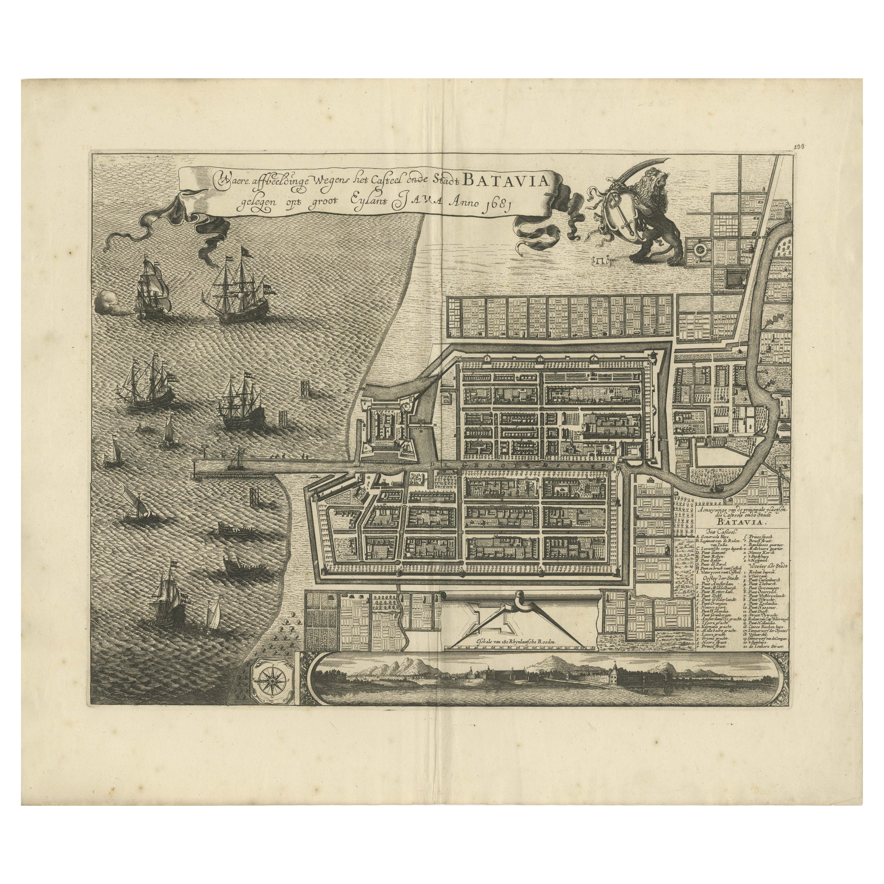
View AllRare 1681 Map of Batavia: Detailed Dutch Colonial Era Cartography, 1681
Located in Langweer, NL
The map of Batavia (modern-day Jakarta) from 1681, attributed to Frederick de Wit holds significant historical importance for several reasons:
Historical Context
1. Colonial Era: This map dates back to the Dutch colonial era when Batavia served as the administrative and commercial hub of the Dutch East India Company (VOC). The VOC was a powerful trading entity that played a crucial role in the global spice trade and colonization in Southeast Asia.
2. Strategic Importance: Batavia was strategically located on the northwestern coast of Java, providing the Dutch with a critical base for their maritime operations. The city became the center of Dutch political and military control in the region.
Cartographic Significance
1. Detailed Urban Layout: The map meticulously details the layout of Batavia, including its fortifications, canals, streets, and significant buildings. This level of detail provides insights into the urban planning and architectural styles of the period.
2. Military Engineering: The fortifications shown on the map illustrate the advanced military engineering techniques used by the Dutch to protect their valuable colony. The walls, bastions, and moats indicate the strategic considerations taken to defend against potential invasions.
3. Maritime Activity: The depiction of ships in the harbor highlights Batavia's role as a major maritime center. The VOC's fleets were essential for trade routes connecting Europe, Africa, and Asia, making Batavia a crucial node in global commerce.
Artistic and Cultural Value
1. Artistic Elements: The decorative elements, such as the lion holding a shield and the intricate cartouches, reflect the artistic trends of Dutch Golden Age cartography. These embellishments were not only informative but also served to display the cartographer's skill and the map's prestige.
2. Cultural Exchange: Maps like this one provide evidence of cultural exchange between the Dutch and the indigenous populations of Java. The blending of Dutch and local influences can be seen in various aspects of the map and the architecture of the city.
Rarity and Preservation
1. Rarity: Maps from the 17th century, especially those in good condition, are relatively rare and highly valued by collectors and historians. Each map provides a unique snapshot of historical geography and urban development.
2. Preservation of History: This map serves as a historical document, preserving knowledge about Batavia's cityscape, infrastructure, and colonial governance. It helps historians and scholars understand the socio-economic and political dynamics of the period.
Conclusion
The map of Batavia from 1681 is special due to its detailed depiction of one of the most important colonial cities in Southeast Asia during the Dutch Golden Age. It reflects the strategic, economic, and cultural significance of Batavia, serving as a valuable resource for understanding the history of Dutch colonialism and its global impact. The map's artistry and precision make it an important artifact in the history of cartography.
---------------
The map is an original and historical map of Batavia (present-day Jakarta) on the island of Java, dated 1681. There are several details to consider when evaluating its origins and possible authorship:
1. **Style and Detail**: The intricate details and style are reminiscent of maps created by Frederick de Wit, a prominent Dutch cartographer and engraver of the 17th century. He was known for his detailed city maps and sea charts.
2. **Lack of Signature**: The absence of "F. de Wit, Excudit" could indicate either an omission or a different engraver. However, it is essential to note that some maps from that period were reproduced or copied by other engravers and cartographers. This was not uncommon, as map-making was a collaborative effort, and copies of popular maps were frequently made.
3. **Map Characteristics**:
- The depiction of ships and the detailed fortifications are typical of Dutch cartography in the late 17th century.
- The decorative elements, such as the lion holding a shield, are also characteristic of Dutch map engravers.
4. **Other Possible Engravers**: While Frederick de Wit is a strong candidate, other notable Dutch engravers from that period include Joan Blaeu and Willem Janszoon Blaeu. They also produced highly detailed maps and could potentially be the creators or inspirers of this map.
To determine the precise authorship, you might consider:
- **Comparing** this map with other confirmed works of Frederick de Wit and his contemporaries to identify stylistic similarities and differences.
- **Historical Records**: Consulting historical records or publications related to Dutch cartography in the 17th century might provide more context or even direct references to this particular map.
If you have access to additional details or higher-resolution images of specific sections, it might help further pinpoint the map's origin and authorship.
-------------
Frederick de Wit (1629–1706) was a prominent Dutch cartographer, engraver, and publisher known for his detailed and decorative maps, atlases, and globes. He played a significant role in the Dutch Golden Age of cartography, contributing to the wealth of geographic knowledge and artistic achievement during this period. Here are key aspects of his life and work:
### Biography
- **Early Life**: Frederick de Wit was born in Gouda, Netherlands, in 1629. Little is known about his early years, but he moved to Amsterdam, the epicenter of Dutch cartography, in the mid-17th century.
- **Career Beginnings**: De Wit began his career as an engraver and publisher, initially producing maps that were reissues of earlier works by other cartographers, such as Joan Blaeu and Willem Janszoon Blaeu.
### Contributions to Cartography
- **Mapmaking**: De Wit was known for his meticulous attention to detail and artistic flair. He produced a wide range of maps, including world maps, regional maps, city plans, and maritime charts...
Category
Antique 1680s Maps
Materials
Paper

$5,554 Sale Price
20% Off
Free Shipping
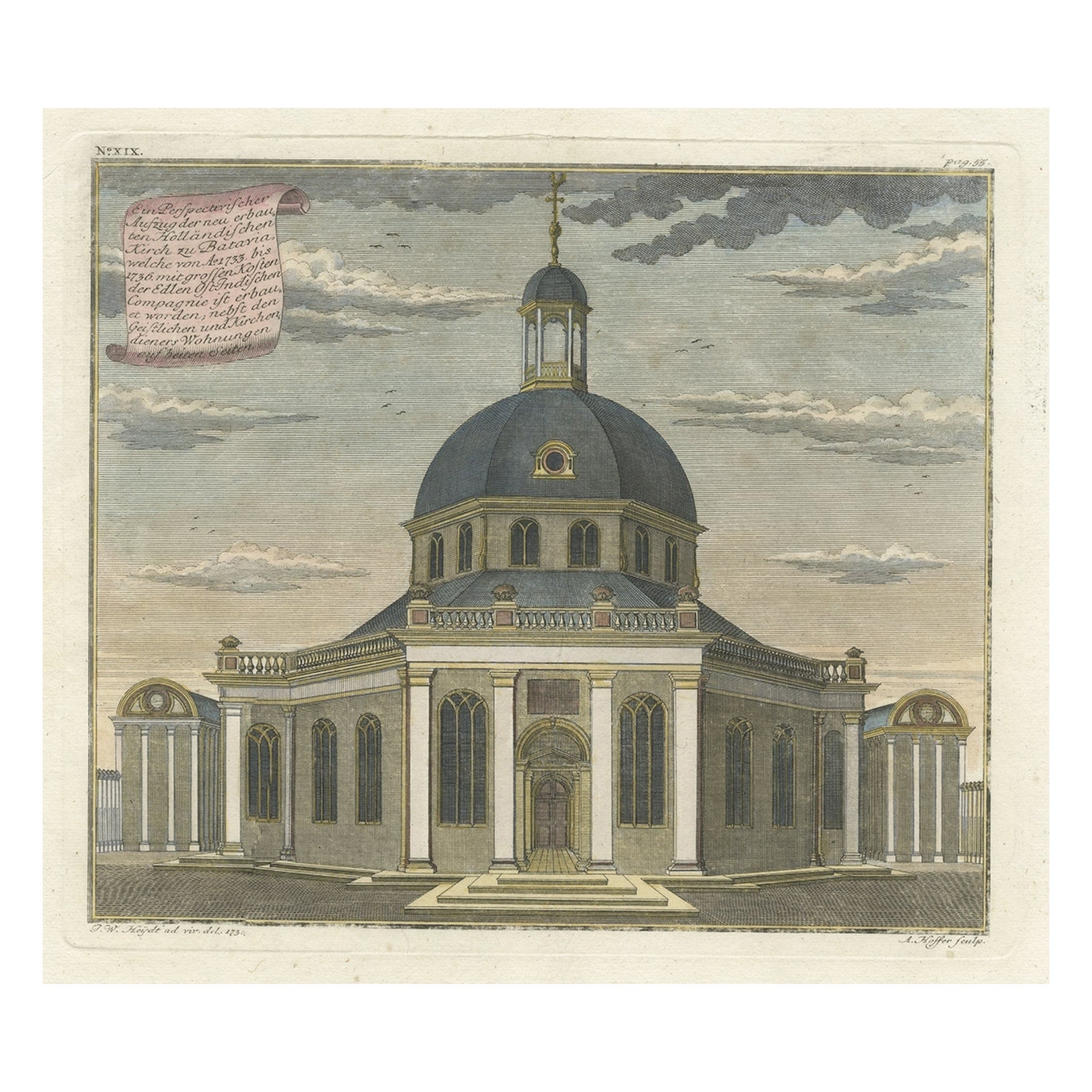
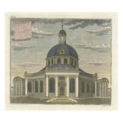
Old Print with a View of the Dutch Church in Batavia 'Jakarta, Indonesia', 1738
Located in Langweer, NL
Antique print titled 'Ein Perspectivischer Aufzug der neu erbauten Holländischen Kirch zu Batavia, welche von Ao. 1733. bis 1736. mit grossen Kosten der Ed;en Ost-Indischen Compagnie...
Category
Antique 1730s Maps
Materials
Paper
$734 Sale Price
20% Off
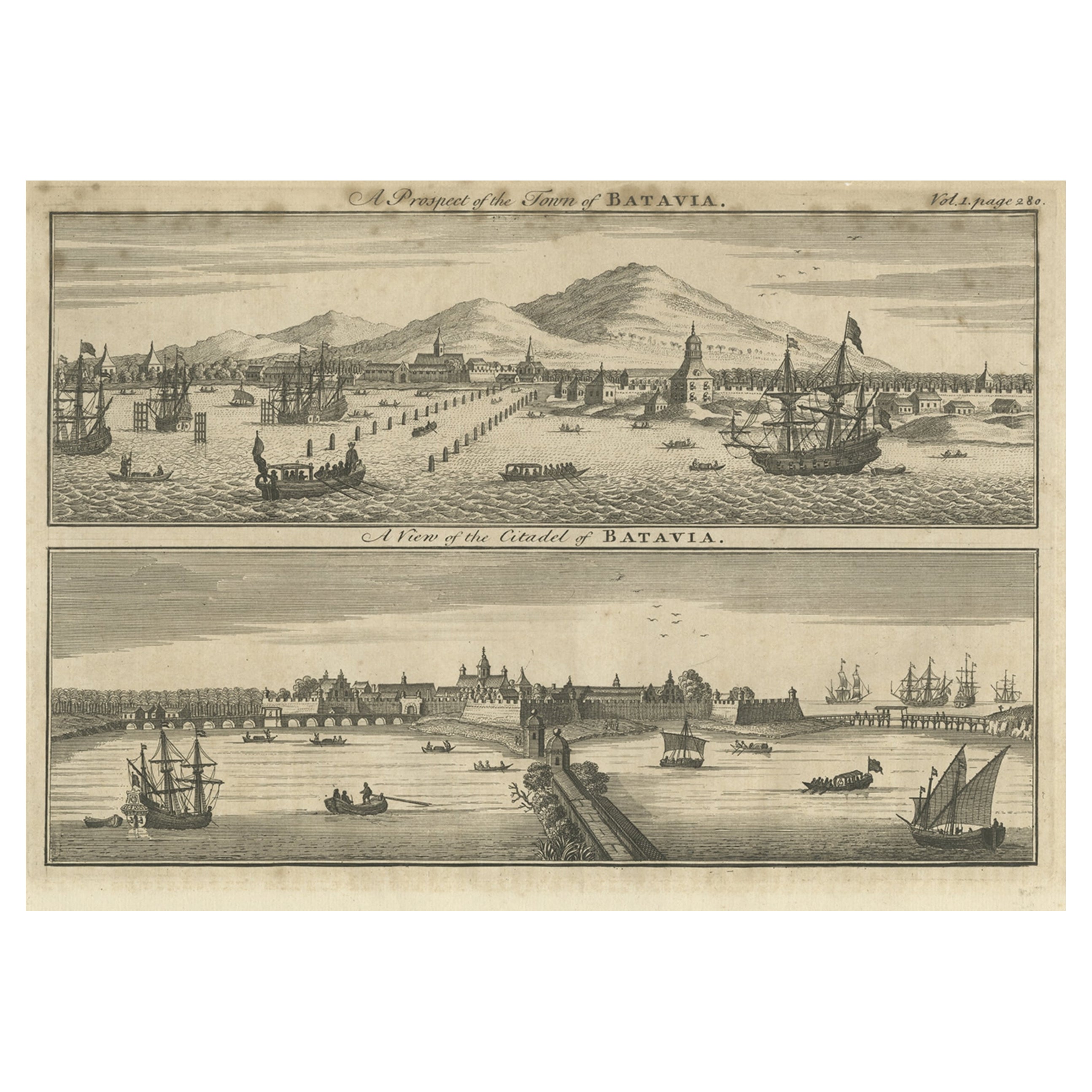
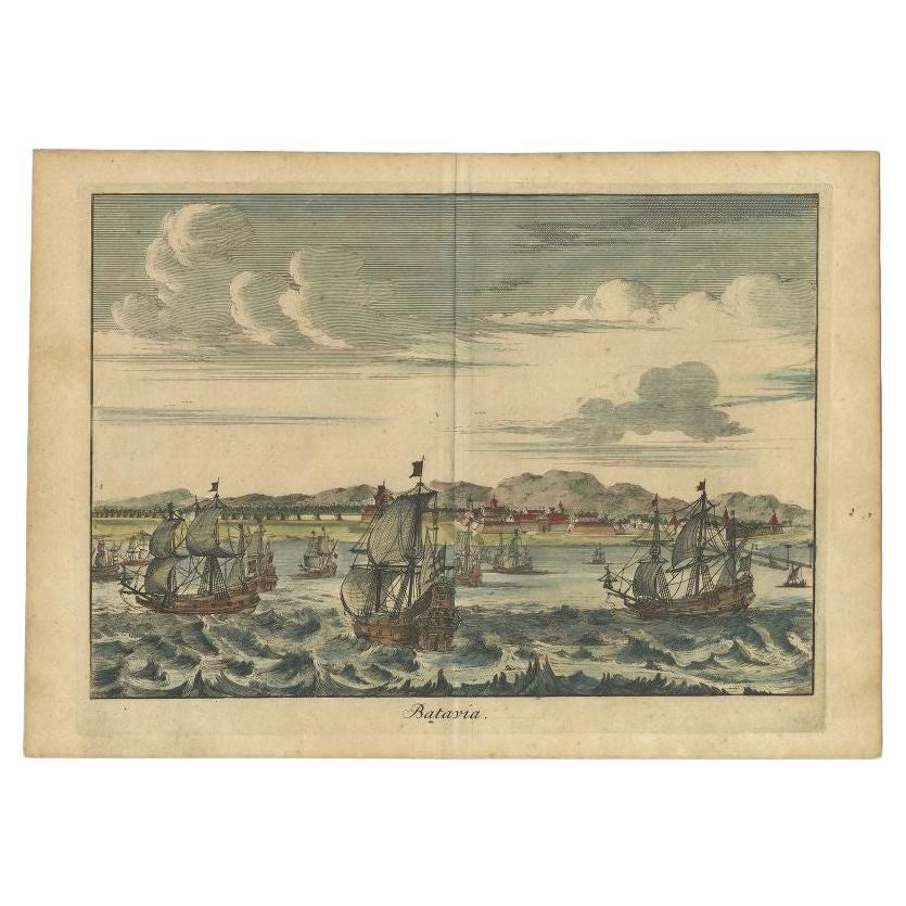
Antique Print of Batavia 'Jakarta', in the Dutch East Indies, 1744
Located in Langweer, NL
Two views on one plate titled 'A Prospect of The Town of Batavia (and) A View of the Citadel of Batavia'. Beautiful views of Batavia (Jakarta), Indonesia. The upper view shows the ci...
Category
Antique 18th Century Prints
Materials
Paper
$207 Sale Price
20% Off
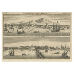
Antique Print of Batavia 'Jakarta' in the Dutch East Indies in Asia, 1705
Located in Langweer, NL
Antique print Indonesia titled 'Batavia'. Beautiful view of Batavia, Indonesia. This print originates from 'Algemeene weereld-beschryving, nae de rechte verdeeling der landschappen (...
Category
Antique 18th Century Prints
Materials
Paper
$508 Sale Price
20% Off
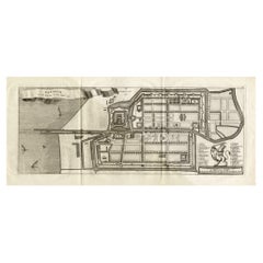
Antique Plan of Batavia and the Castle in the Dutch East Indies, 1763
Located in Langweer, NL
Antique map titled 'Grundriss von der Stadt und dem Schlosse Batavia.' Plan of the city and the castle of Batavia in the Dutch East Indies / Indonesia. From 'Algemeine Welthistorie (...
Category
Antique 18th Century Maps
Materials
Paper

$367 Sale Price
20% Off
Antique Map of Batavia 'Jakarta, Indonesia', the Dutch East-Indies, 1782
Located in Langweer, NL
Antique map titled 'Batavia zo als het was in den Jaare 1731.' (Batavia as it was in the year 1731.) Map of the city of Batavia (Jakarta) in Indonesia. With legend and scale. This pr...
Category
Antique 18th Century Maps
Materials
Paper
$602 Sale Price
20% Off
You May Also Like
Golf Inspired Chess Set in White Bird's-Eye Maple
By Agresti
Located in New York, NY
White bird's-eye maple and erable. Hand-painted golf chessmen.
Category
21st Century and Contemporary Italian Modern Games
Materials
Birdseye Maple
$2,400 / item
Golf Inspired Chess Set in White Bird's-Eye Maple
By Agresti
Located in New York, NY
White bird’s-eye maple and green marble chess set. Hand painted Golf chessmen.
Category
21st Century and Contemporary Italian Modern Games
Materials
Birdseye Maple
$2,400 / item
Mid-19th Century Bird's-Eye Maple Simulated Miniature Chest
Located in Bedfordshire, GB
A charming mid-19th century simulated bird's-eye
Maple miniature chest of three long drawers
With original turned wooden knobs raised
On original plinth
(There is often debate ...
Category
Antique Mid-19th Century English Victorian Models and Miniatures
Materials
Birdseye Maple

Detailed Model of Dutch Sailing Ship From the 1930s-1940s
Located in Opole, PL
Detailed Model of Dutch Sailing Ship From the 1930s-1940s
A faithfully reproduced model of a vessel dating back to the Interwar Period of the 20th ...
Category
Early 20th Century Dutch Models and Miniatures
Materials
Wood
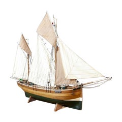
$742 Sale Price
20% Off
Detailed Model of Dutch Sailing Ship Circa 1930s-1940s
Located in Opole, PL
Detailed Model of Dutch Sailing Ship Circa 1930s-1940s
A faithfully reproduced model of a vessel dating back to the Interwar Period of the 20th century. In particularly good condition.
Category
Early 20th Century Dutch Models and Miniatures
Materials
Wood
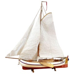
$649 Sale Price
20% Off
New Map of North America from the Latest Discoveries, 1763
Located in Philadelphia, PA
A fine antique 18th century map of the North American seaboard.
Entitled "A New Map of North America from the Latest Discoveries 1763".
By the Cartographer/Engraver - John Spil...
Category
Antique Mid-18th Century English Georgian Maps
Materials
Paper

Recently Viewed
View AllMore Ways To Browse
Woven Sling Chair
Wrought Iron Curule Bench
Yellow Ware Seaweed
Yoruba Textile
Yugoslavian Dining Chairs
Zeppelin Airship
10 Cab Chairs
108 Inch Dining Room Table
15 Ft Runner
1770 English Chair
17th Century Cane Chairs
17th Century Dutch Picture Frame
18th Century Oak Refectory Table
18th Century Salon Suite
1900 Bar Cart
1900s Bureau
1930s Birmingham Silver
1930s Upholstery Loveseats