Items Similar to 1882 Map of the Pacific Ocean Highlighting Islands and Surrounding Regions


Want more images or videos?
Request additional images or videos from the seller
1 of 7
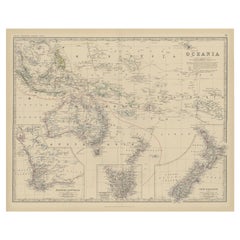
1882 Map of the Pacific Ocean Highlighting Islands and Surrounding Regions
$298.23
£220.48
€250
CA$410.21
A$455.97
CHF 239.01
MX$5,568.52
NOK 2,983.91
SEK 2,807.30
DKK 1,903.25
About the Item
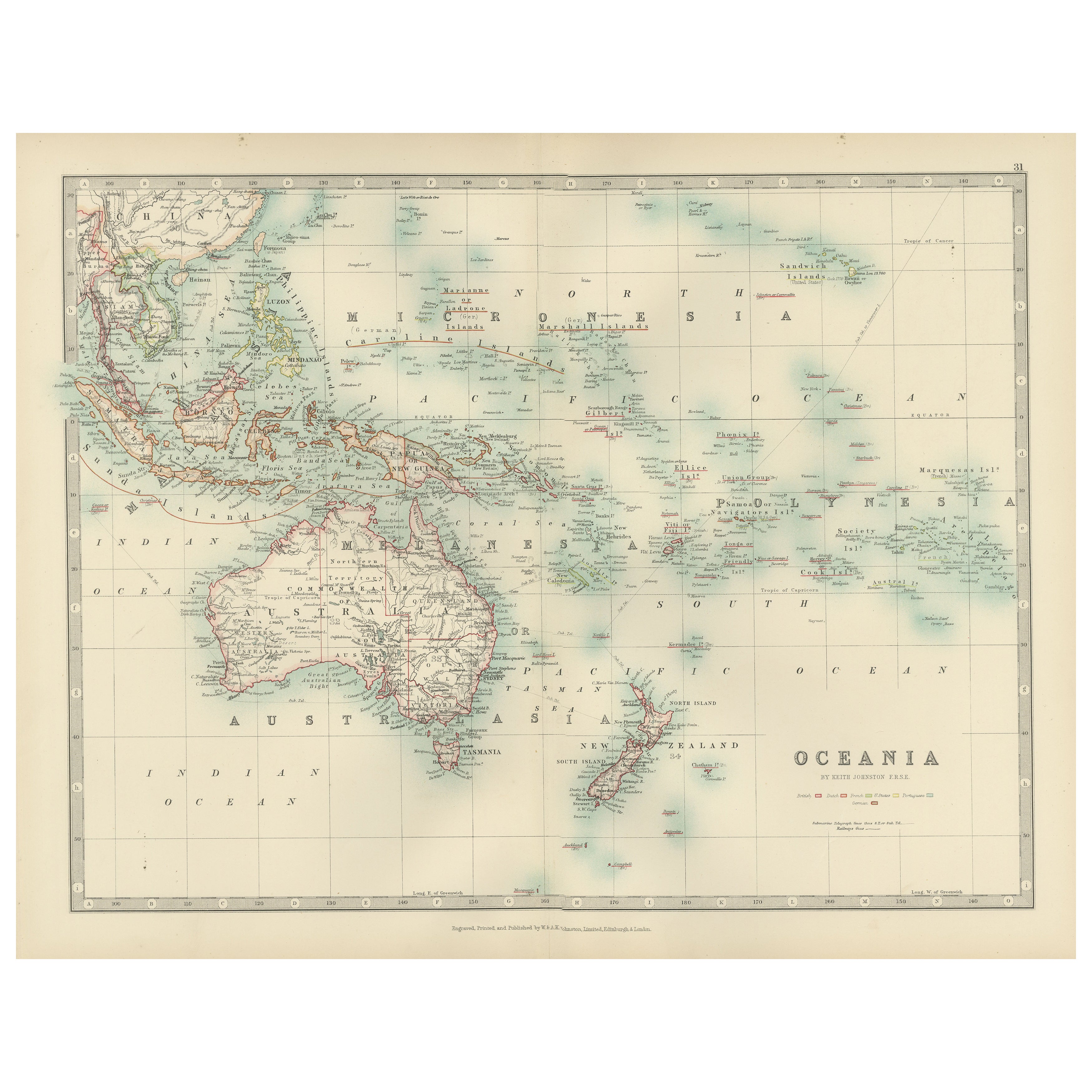
This 1882 map of the Pacific Ocean, published by Blackie and Son as part of the 'Comprehensive Atlas and Geography of the World,' presents a detailed and fascinating overview of the world’s largest ocean and its surrounding regions. The map highlights key islands and archipelagos scattered across the vast expanse of the Pacific, including the Hawaiian Islands, the Philippines, New Guinea, New Zealand, and the islands of Polynesia, Micronesia, and Melanesia. It also includes parts of the continents bordering the Pacific, such as the west coast of North and South America, Asia, and Australia.
Maritime routes and major shipping lanes are illustrated, reflecting the importance of the Pacific for global trade and exploration during the late 19th century. The geographic details extend to underwater features and coastal contours, providing insight into the physical characteristics of the ocean and its shores. Subtle pastel coloring is used to delineate political territories and boundaries, enhancing the clarity and aesthetic appeal of the map.
Condition report: The map is in good condition, with minimal signs of age-related toning and spotting. The paper remains strong, the engraving is sharp, and the pastel colors are well-preserved. There are no visible tears or repairs.
Framing tips: Use a classic wooden frame in walnut or dark oak to emphasize the map's vintage appeal. A double mat with a cream or off-white inner mat and a soft blue or light beige outer mat complements the oceanic theme. UV-protective glass is recommended to safeguard against fading and preserve the map’s condition for long-term display.
- Dimensions:Height: 14.97 in (38 cm)Width: 22.45 in (57 cm)Depth: 0 in (0.02 mm)
- Materials and Techniques:
- Period:
- Date of Manufacture:1882
- Condition:Condition report: The map is in good condition with minimal edge wear. Slight toning and occasional spotting are present, consistent with its age. The engraving remains sharp, and the colors are well-preserved. Fold line in middle, as issued.
- Seller Location:Langweer, NL
- Reference Number:Seller: BG-13601-2-761stDibs: LU3054343552852
About the Seller
5.0
Recognized Seller
These prestigious sellers are industry leaders and represent the highest echelon for item quality and design.
Platinum Seller
Premium sellers with a 4.7+ rating and 24-hour response times
Established in 2009
1stDibs seller since 2017
2,604 sales on 1stDibs
Typical response time: <1 hour
- ShippingRetrieving quote...Shipping from: Langweer, Netherlands
- Return Policy
Authenticity Guarantee
In the unlikely event there’s an issue with an item’s authenticity, contact us within 1 year for a full refund. DetailsMoney-Back Guarantee
If your item is not as described, is damaged in transit, or does not arrive, contact us within 7 days for a full refund. Details24-Hour Cancellation
You have a 24-hour grace period in which to reconsider your purchase, with no questions asked.Vetted Professional Sellers
Our world-class sellers must adhere to strict standards for service and quality, maintaining the integrity of our listings.Price-Match Guarantee
If you find that a seller listed the same item for a lower price elsewhere, we’ll match it.Trusted Global Delivery
Our best-in-class carrier network provides specialized shipping options worldwide, including custom delivery.More From This Seller
View AllAntique Map of Australasia, New Zealand, Polynesia & the Pacific Ocean, 1840
Located in Langweer, NL
Antique map titled 'The Pacific Ocean'.
This map depicts Australasia, New Zealand, Polynesia and islands in the Pacific Ocean including the Sandwich Islands.
Artists and Engravers: Published by the Society for the Diffusion of Useful Knowledge, 1840. Engraved by J. & C. Walker.
Condition:
Good, general age-related toning. Few tiny tears...
Category
Antique 1840s Maps
Materials
Abalone, Paper

$209 Sale Price
20% Off
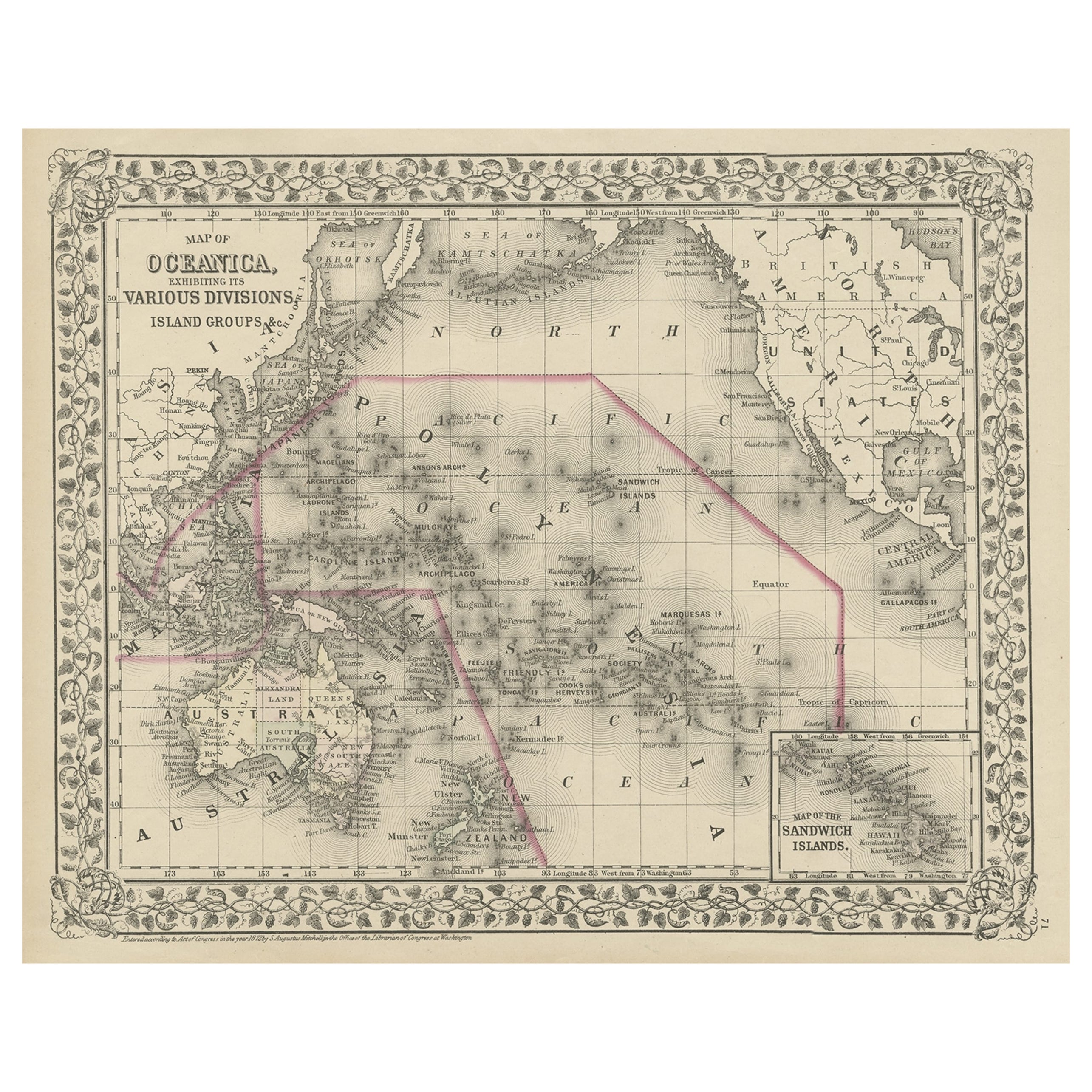
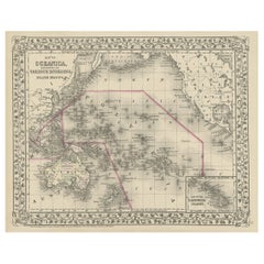
Old Map of the Pacific, Incl Australia, Polynesia, Melanesia and Malaysia, 1872
Located in Langweer, NL
Antique map Oceania titled 'Map of Oceanica exhibiting its various divisions, island groups & c'.
Map of the Pacific, including Australia, Polynes...
Category
Antique 1870s Maps
Materials
Paper
$181 Sale Price
20% Off
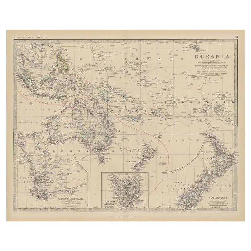
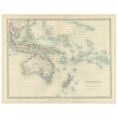
Antique Map of Oceania by Johnston, 1882
Located in Langweer, NL
Antique map titled 'Oceania'. Old map of Oceania with inset maps of Western Australia, Tasmania and New Zealand. This map originates from 'The Royal Atlas of Modern Geography, Exhibi...
Category
Antique 19th Century Maps
Materials
Paper
$124 Sale Price
20% Off
Antique Map of the Islands in the Pacific Ocean by Wyld, '1845'
Located in Langweer, NL
Antique map titled 'Islands in the Pacific Ocean'. Original antique map of the islands in the Pacific Ocean. This map originates from 'An Atlas of the World, Comprehending Separate M...
Category
Antique Mid-19th Century Maps
Materials
Paper

$190 Sale Price
20% Off
Antique Map of Oceania, 1903, Featuring the Pacific Islands and Australasia
Located in Langweer, NL
Title: Antique Map of Oceania, 1903, Featuring the Pacific Islands and Australasian Region
Description:
This antique map, titled "Oceania," was engraved and published in 1903 by W. ...
Category
Early 20th Century Maps
Materials
Paper
1882 Map of the North Atlantic Ocean Showing Cable Tracks and Trade Winds
Located in Langweer, NL
This 1882 map of the North Atlantic Ocean, published by Blackie and Son as part of the 'Comprehensive Atlas and Geography of the World,' provides an intricate depiction of one of the...
Category
Antique 1880s Maps
Materials
Paper
You May Also Like
Large Original Antique Map of The Pacific Ocean, Fullarton, C.1870
Located in St Annes, Lancashire
Great map of The Pacific Ocean
From the celebrated Royal Illustrated Atlas
Lithograph by Swanston. Original color.
Published by Fullarton,...
Category
Antique 1870s Scottish Maps
Materials
Paper

Original Antique Map of US Possessions In The Pacific Ocean, C.1900
Located in St Annes, Lancashire
Fabulous map of US possessions in the Pacific Ocean
Original color.
Engraved and printed by the George F. Cram Company, Indianapolis.
Published, C.1900.
Unframed.
Free shipping.
Category
Antique 1890s American Maps
Materials
Paper

Large Original Vintage Map of The Pacific Islands Including Hawaii
Located in St Annes, Lancashire
Great map of The Pacific Islands
Unframed
Original color
By John Bartholomew and Co. Edinburgh Geographical Institute
Published, circa 1...
Category
Vintage 1920s British Maps
Materials
Paper

1850 Old French Map Depicting the Entire Earth's Surface Divided into Two Parts
Located in Milan, IT
Geographical map depicting the entire earth's surface divided into two parts that correspond to the two hemispheres where the emerged lands are depicted which have been classified wi...
Category
Antique Mid-19th Century French Maps
Materials
Glass, Wood, Paper

1864 Johnson's Map of the World on Mercator's Projection, Ric.B009
Located in Norton, MA
An 1864 Johnson's map of
the World on Mercator's Projection
Ric.b009
About this Item
"This antique map came from Johnson's New Illustrated (Steel Plate) Family Atlas, publ...
Category
Antique 19th Century Dutch Maps
Materials
Paper

Original Antique Map of Hawaii And Adjacent Islands. C.1900
Located in St Annes, Lancashire
Fabulous map of Hawaii. With a vignette of Honolulu
Original color.
Engraved and printed by the George F. Cram Company, Indianapolis.
Published, C.1900.
Unframed.
Free shipping.
Category
Antique 1890s American Maps
Materials
Paper

More Ways To Browse
Long Island Used Furniture
Lane Antique Furniture
Philippines Antique
Hawaiian Antique
Antique Oak Island
White Oak Island
Antique Hawaiian Furniture
Hawaiian Collectibles
Lane Delineator
Post Modern High Chairs
Vintage Vine Rug
Silver Metal Chair
Swedish Kilim
Vintage Scandanavian Chairs
Vintage Tropical Furniture
19th Century Red Glass
Antique French Console Table Tables
French 50s