Items Similar to Antique Decorative Map of Saone and Loire in France, 1854

Want more images or videos?
Request additional images or videos from the seller
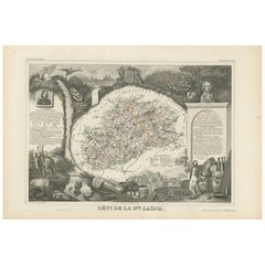
Antique Decorative Map of Saone and Loire in France, 1854
About the Item
Antique map titled 'Dépt. de Saône et Loire'. Map of the French department of Saone et Loire, France. Part of France's important Burgundy or Bourgogne Wine Region. Produces Mercurey and Givry among other red wines. Around Mâcon are whites of fine quality, notably Rully, Montagny, and also Pouilly-Fuissé, a dry, heady wine with much bouquet. The map is surrounded by elaborate decorative engravings designed to illustrate both the natural beauty and trade richness of the land. There is a short textual history of the regions depicted on both the left and right sides of the map. This map originates from ?Atlas National de la France Illustré? by V. Levasseur. Arists and Engravers: Published by A. Combette, Paris, 1854.
Artist: Published by A. Combette, Paris, 1854.
Condition: Good, general age-related toning. Few defects in margins. Blind stamp below verso. Blank verso, please study image carefully.
Date: 1854
Overall size: 53 x 36.5 cm.
Image size: 0.001 x 41 x 27.5 cm.
Antique prints have long been appreciated for both their aesthetic and investment value. They were the product of engraved, etched or lithographed plates. These plates were handmade out of wood or metal, which required an incredible level of skill, patience and craftsmanship. Whether you have a house with Victorian furniture or more contemporary decor an old engraving can enhance your living space. We offer a wide range of authentic antique prints for any budget.
- Dimensions:Height: 14.38 in (36.5 cm)Width: 20.87 in (53 cm)Depth: 0 in (0.01 mm)
- Materials and Techniques:
- Period:
- Date of Manufacture:1854
- Condition:
- Seller Location:Langweer, NL
- Reference Number:Seller: BG-12418-131stDibs: LU3054327619062
About the Seller
5.0
Platinum Seller
These expertly vetted sellers are 1stDibs' most experienced sellers and are rated highest by our customers.
Established in 2009
1stDibs seller since 2017
1,956 sales on 1stDibs
Typical response time: <1 hour
- ShippingRetrieving quote...Ships From: Langweer, Netherlands
- Return PolicyA return for this item may be initiated within 14 days of delivery.
More From This SellerView All
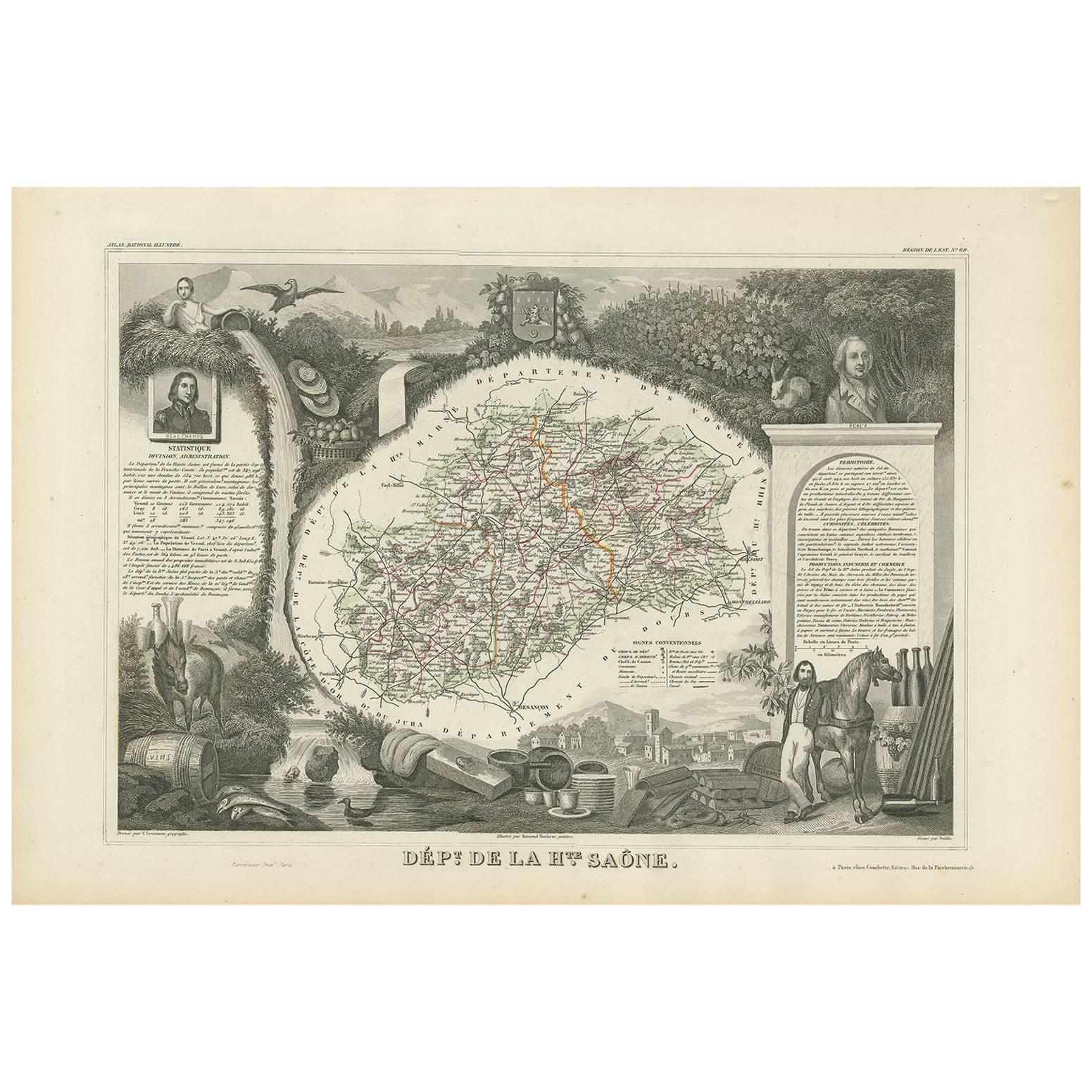
- Antique Map of Haute-Saone, France by V. Levasseur, 1854By Victor LevasseurLocated in Langweer, NLAntique map titled 'Dépt. de la Hte. Saône'. Map of the French department of Haute-Saone, France. Part of France's important Burgundy or Bourgogne Wine Region. This area is home to t...Category
Antique Mid-19th Century Maps
MaterialsPaper
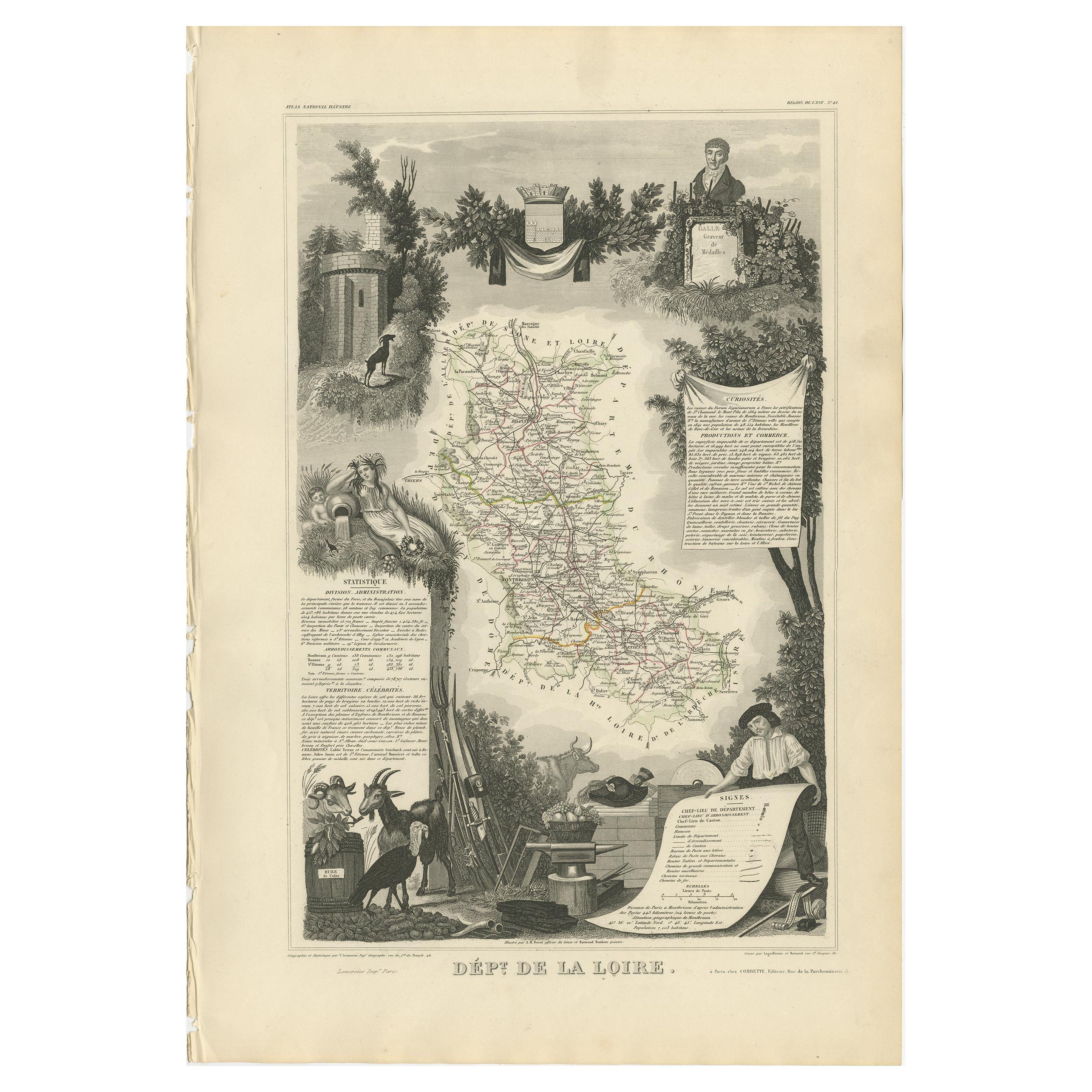
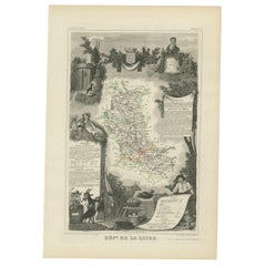
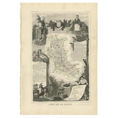
- Antique Map of Loire ‘France’ by V. Levasseur, 1854Located in Langweer, NLAntique map titled 'Dépt. de la Loire'. Map of the French department of Loire, France. This area of France is part of the Loire Valley wine growing region. The area includes 87 appel...Category
Antique Mid-19th Century Maps
MaterialsPaper
- Antique Map of Loire ‘France’ by V. Levasseur, 1854Located in Langweer, NLAntique map titled 'Dépt. de la Loire'. Map of the French department of Loire, France. This area of France is part of the Loire Valley wine growing region...Category
Antique Mid-19th Century Maps
MaterialsPaper
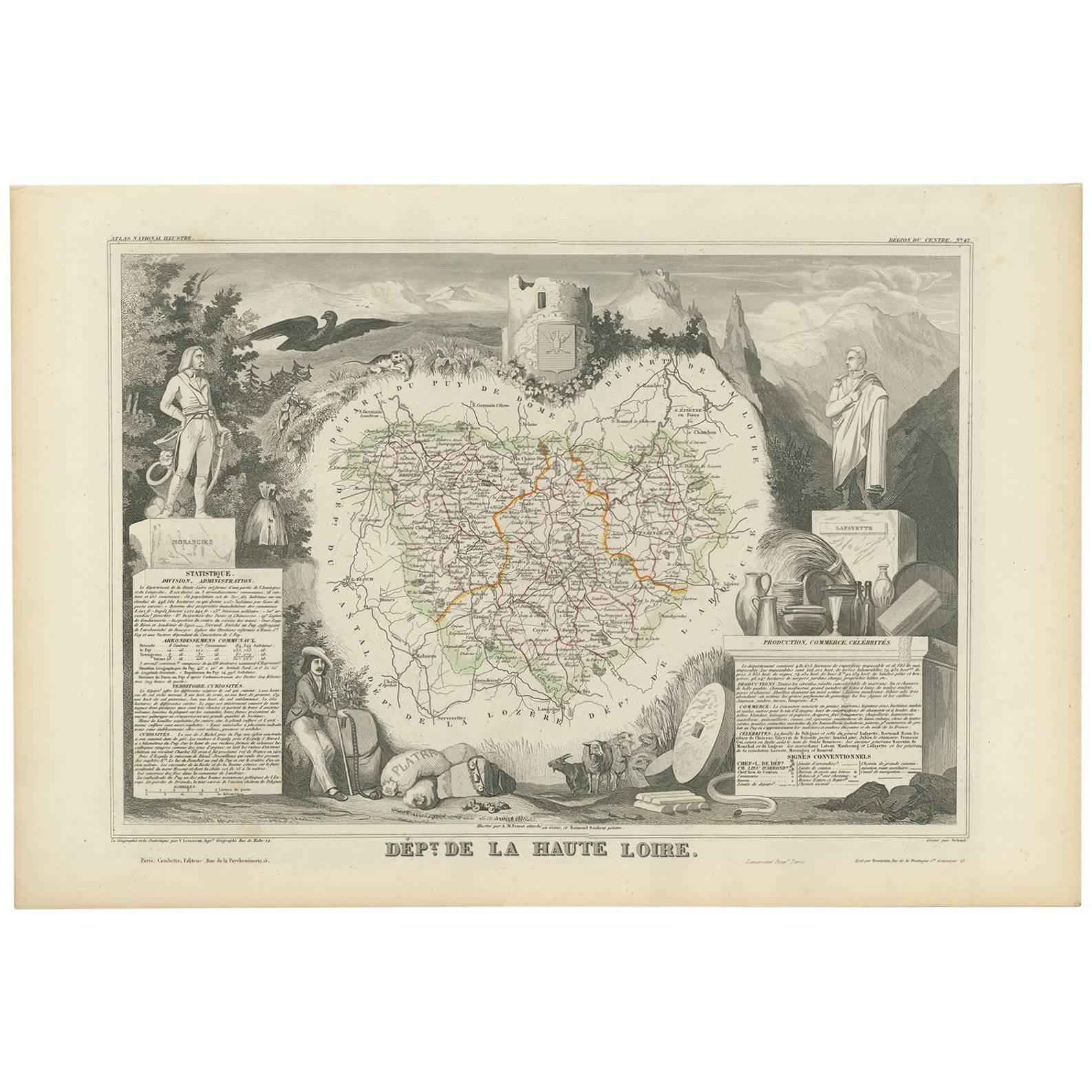
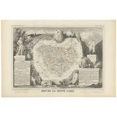
- Antique Map of Haute Loire ‘France’ by V. Levasseur, 1854Located in Langweer, NLAntique map titled 'Dépt. de la Haute Loire'. Map of the French department of Haute Loire, France. This area of France is part of the Loire Valley wine growing region. It is also kno...Category
Antique Mid-19th Century Maps
MaterialsPaper
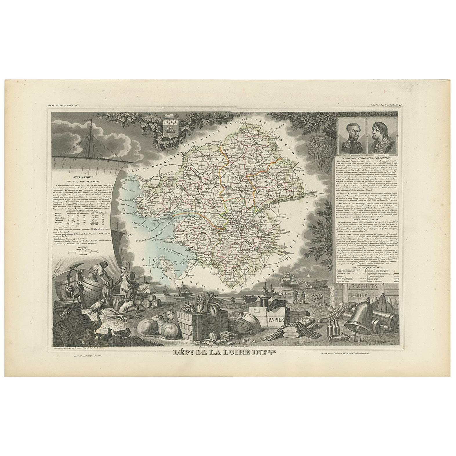
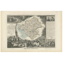
- Antique Map of Loire Inferieure ‘France’ by V. Levasseur, 1854Located in Langweer, NLAntique map titled 'Dépt. de la Loire Inferieure'. Map of the French department of Loire Inferieure, France (currently known as Loire-Atlantique.) This area of France is part of the ...Category
Antique Mid-19th Century Maps
MaterialsPaper
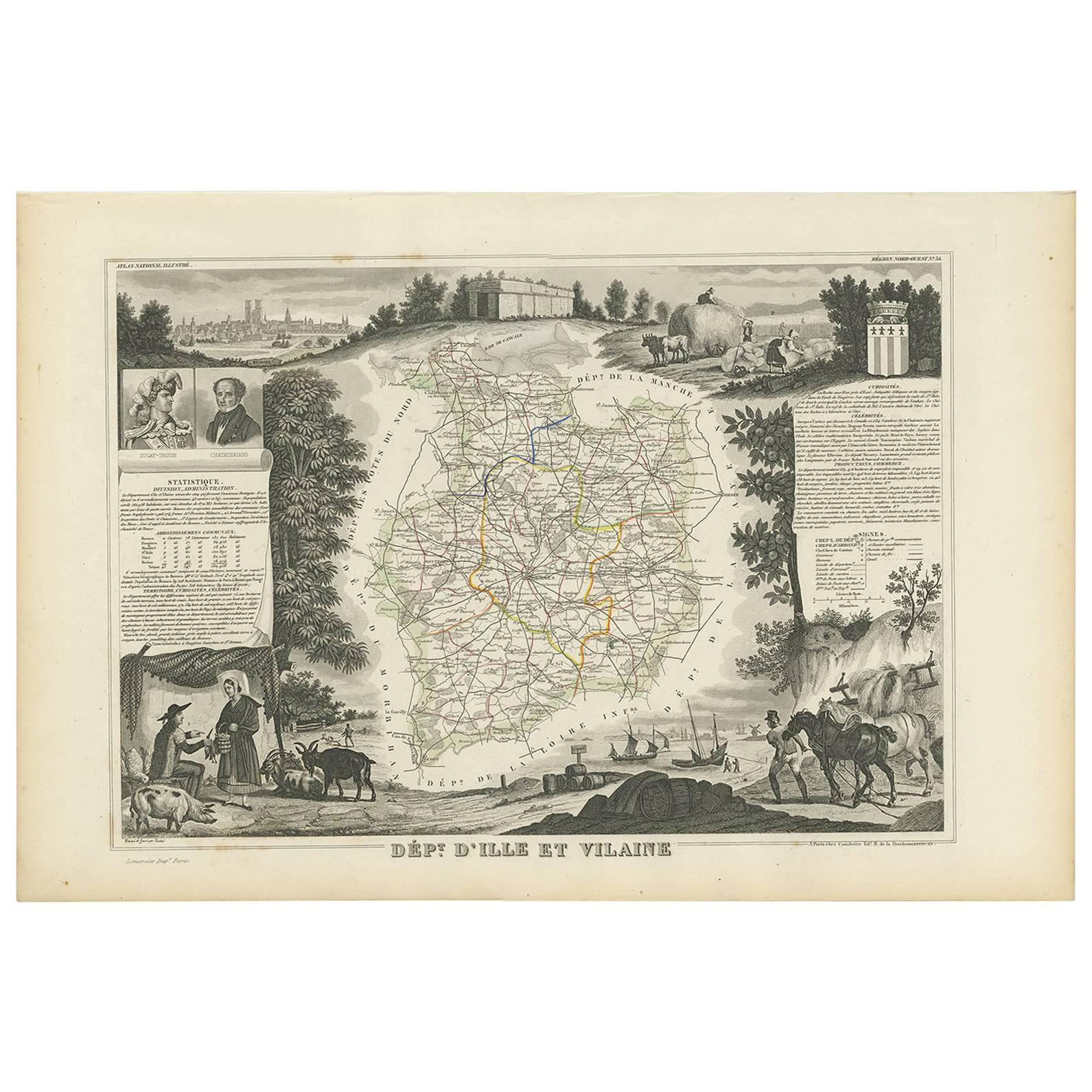
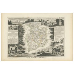
- Antique Map of Ille et Vilaine ‘France’ by V. Levasseur, 1854Located in Langweer, NLAntique map titled 'Dépt. d'Ille et Vilaine'. Map of the French department of Ille et Vilaine. France. Its coastal area is famous for its seafood, and especially its oysters. The reg...Category
Antique Mid-19th Century Maps
MaterialsPaper
You May Also Like
- Original Antique Decorative Map of Japan, Fullarton, C.1870Located in St Annes, LancashireGreat map of Japan Wonderful figural border From the celebrated Royal Illustrated Atlas Lithograph. Original color. Published by Fullarton, Edinburgh, C.1870 Unframed...Category
Antique 1870s Scottish Maps
MaterialsPaper
- Original Antique Decorative Map of Iceland & Faroe, Fullarton, C.1870Located in St Annes, LancashireGreat map of Iceland and The Faroe Islands Wonderful figural border From the celebrated Royal Illustrated Atlas Lithograph. Original color. Published by Fullarton, Edinb...Category
Antique 1870s Scottish Maps
MaterialsPaper
- Original Antique Decorative Map of South America-West Coast, Fullarton, C.1870Located in St Annes, LancashireGreat map of Chili, Peru and part of Bolivia Wonderful figural border From the celebrated Royal Illustrated Atlas Lithograph. Original color. Published by Fullarton, Edi...Category
Antique 1870s Scottish Maps
MaterialsPaper
- Original Antique Map of Missouri, 1889Located in St Annes, LancashireGreat map of Missouri Drawn and Engraved by W. & A.K. Johnston Published By A & C Black, Edinburgh. Original colour Unframed.Category
Antique 1880s Scottish Victorian Maps
MaterialsPaper

- Original Antique Map of Indonesia, 1861Located in St Annes, LancashireGreat map of Indonesia Drawn and engraved by Edward Weller Original color Published in The Weekly Dispatch Atlas, 1861 Repairs to minor e...Category
Antique 1860s English Victorian Maps
MaterialsPaper

- Original Large Antique Map of Paris, France by John Dower, 1861Located in St Annes, LancashireFabulous monochrome map of Paris. Vignettes of St Germain En Laye, Saint Cloud, Versailles and Fontainbleau. Unframed. Drawn by J.Dower. Lithography by Weller. 4 sheets j...Category
Antique 1860s English Victorian Maps
MaterialsPaper


Recently Viewed
View AllMore Ways To Browse
Burgundy Map
Map Of Burgundy
Antique Map Burgundy
Small Antique Globes
Maps United Kingdom
Antique Surveying
Antique Style Map
Antique City Plans
Antique New York Map
Antique Map New York
Antique New York Maps
Antique Maps New York
Modes And More
New York Antique Map
Old Antique Globes
Antique Scottish Wood Furniture
Antique Scottish Maps
Antique Map Scotland