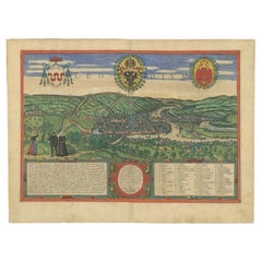
Antique Map of Aden, Mombasa, Kilwa and Sofala by Braun & Hogenberg, circa 1575
View Similar Items


Want more images or videos?
Request additional images or videos from the seller
1 of 5
Antique Map of Aden, Mombasa, Kilwa and Sofala by Braun & Hogenberg, circa 1575
About the Item
- Creator:Georg Braun and Frans Hogenberg (Artist)
- Dimensions:Height: 16.15 in (41 cm)Width: 21.26 in (54 cm)Depth: 0.02 in (0.5 mm)
- Materials and Techniques:
- Place of Origin:
- Period:
- Date of Manufacture:circa 1575
- Condition:Wear consistent with age and use. Small split on folding line. Please study images carefully.
- Seller Location:Langweer, NL
- Reference Number:Seller: BG-116611stDibs: LU3054313511652
About the Seller
5.0
Recognized Seller
These prestigious sellers are industry leaders and represent the highest echelon for item quality and design.
Gold Seller
Premium sellers maintaining a 4.3+ rating and 24-hour response times
Established in 2009
1stDibs seller since 2017
2,452 sales on 1stDibs
Authenticity Guarantee
In the unlikely event there’s an issue with an item’s authenticity, contact us within 1 year for a full refund. DetailsMoney-Back Guarantee
If your item is not as described, is damaged in transit, or does not arrive, contact us within 7 days for a full refund. Details24-Hour Cancellation
You have a 24-hour grace period in which to reconsider your purchase, with no questions asked.Vetted Professional Sellers
Our world-class sellers must adhere to strict standards for service and quality, maintaining the integrity of our listings.Price-Match Guarantee
If you find that a seller listed the same item for a lower price elsewhere, we’ll match it.Trusted Global Delivery
Our best-in-class carrier network provides specialized shipping options worldwide, including custom delivery.More From This Seller
View AllAntique Map of Douai 'France' by Braun & Hogenberg, circa 1575
Located in Langweer, NL
Beautiful map in excellent condition. This map depicts the city of Douai (France) and originates from 'Civitates Orbis Terrarum'.
Category
Antique 16th Century Maps
Materials
Paper

$512 Sale Price
20% Off
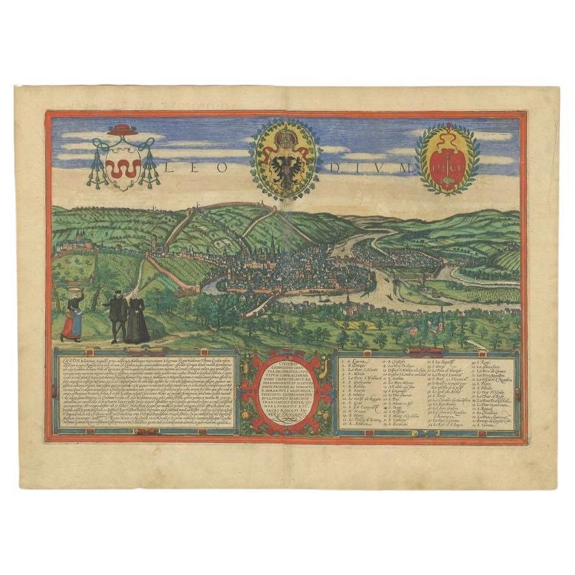
Antique Print of Liège / Luik in Belgium by Braun & Hogenberg, 1575
Located in Langweer, NL
Antique print titled 'Leodium'. View of Liège / Luik, Belgium with surrounding hills and the city wall. With text explaining the origins of Liège, a cartouche expressing thanks to th...
Category
Antique 16th Century Prints
Materials
Paper
$1,247 Sale Price
20% Off
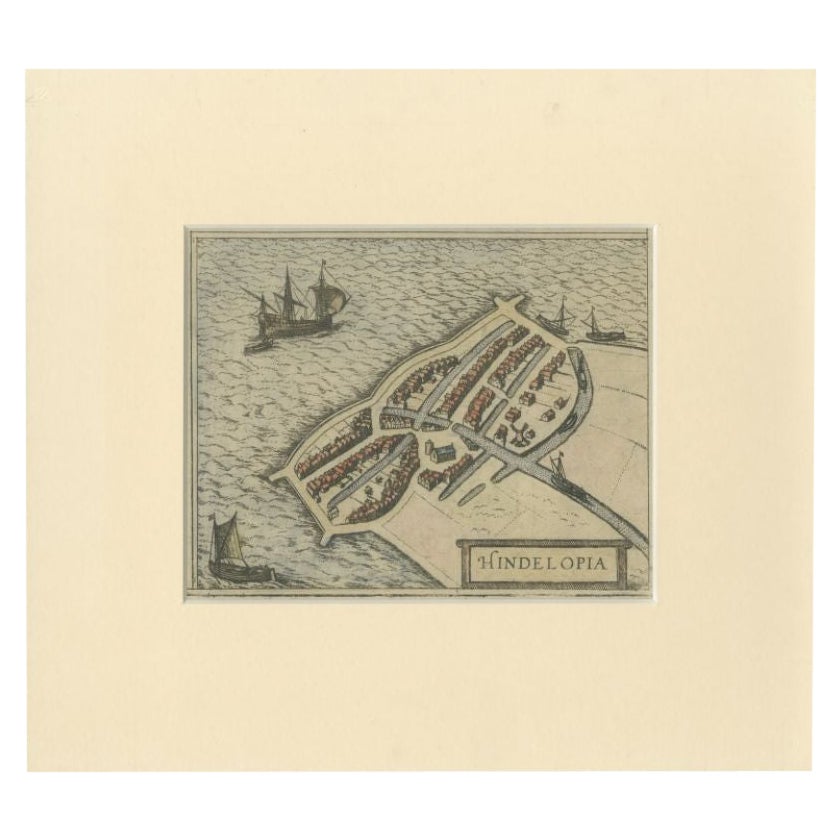
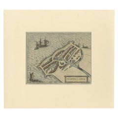
Antique Map of the City of Hindeloopen by Braun & Hogenberg, c.1598
Located in Langweer, NL
Antique map titled 'Hindelopia'. Original antique map of the city of Hindeloopen, Friesland, the Netherlands. Originally published on one sheet together with other Frisian cities, trimmed. This print originates from the town atlas by Braun and Hogenberg...
Category
Antique 16th Century Maps
Materials
Paper
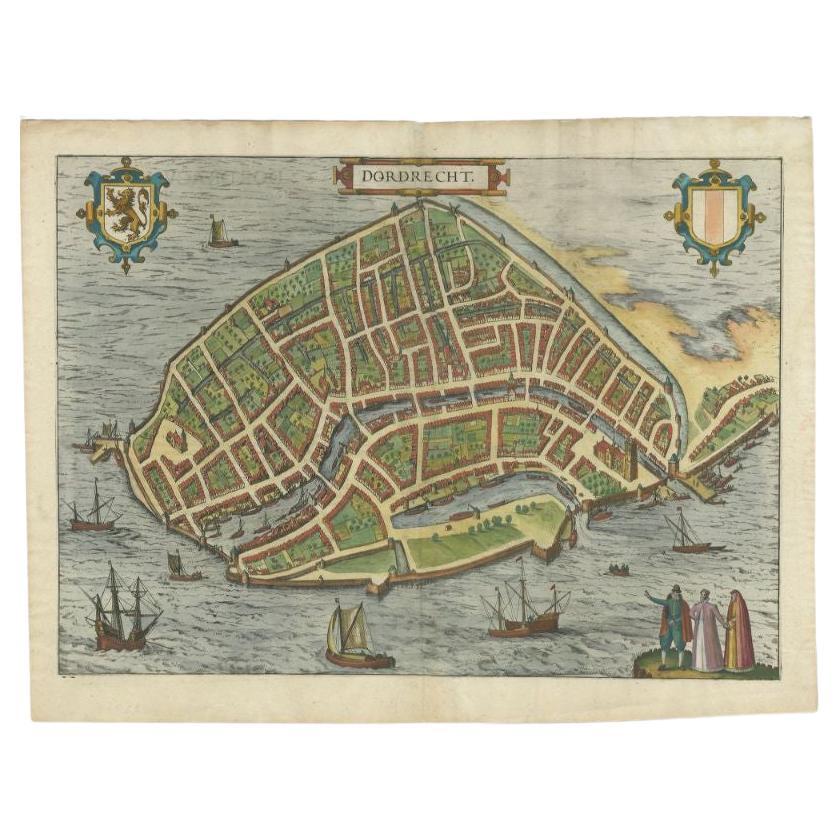
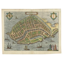
Antique Map of the City of Dordrecht by Braun & Hogenberg, c.1581
Located in Langweer, NL
Antique map titled 'Dordrecht'. Map of the city of Dordrecht, the Netherlands. Bird's-eye plan view of the city, with many ships and two coats of arms in upper corners. This map orig...
Category
Antique 16th Century Maps
Materials
Paper
$391 Sale Price
20% Off
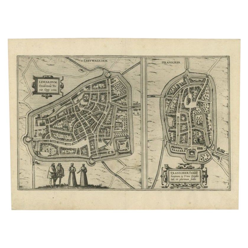
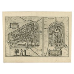
Antique Map of the City of Leeuwarden and Franeker by Braun & Hogenberg, 1580
Located in Langweer, NL
Antique map titled 'Lewardum Occidentlis Frisiae Opp: 1580, Franicher Nobiliu hominum, in Frisia Occidentali, ut plurimum saedes'. This sheet contains two very detailed bird’s-eye pl...
Category
Antique 16th Century Maps
Materials
Paper
$302 Sale Price
20% Off
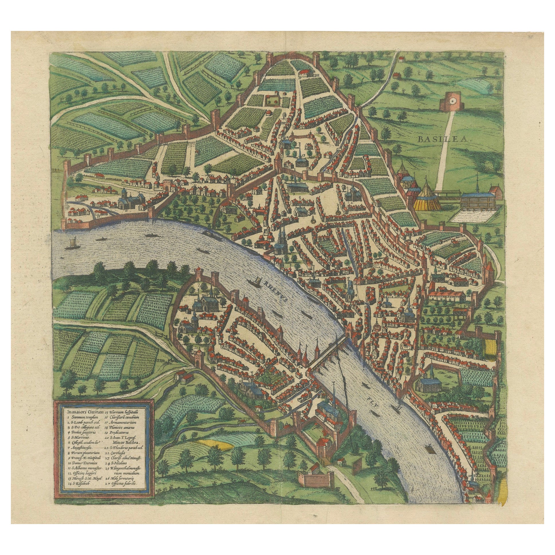
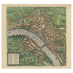
Bird’s-Eye View of Basel from Braun & Hogenberg’s Civitates Orbis Terrarum, 1575
Located in Langweer, NL
Bird’s-Eye View of Basel from Braun & Hogenberg’s "Civitates Orbis Terrarum" (Circa 1572-1617)
This highly detailed map of Basel is a bird's-eye view, originally based on Sebastian Münster’s map...
Category
Antique 16th Century Maps
Materials
Paper
$1,117 Sale Price
20% Off
You May Also Like
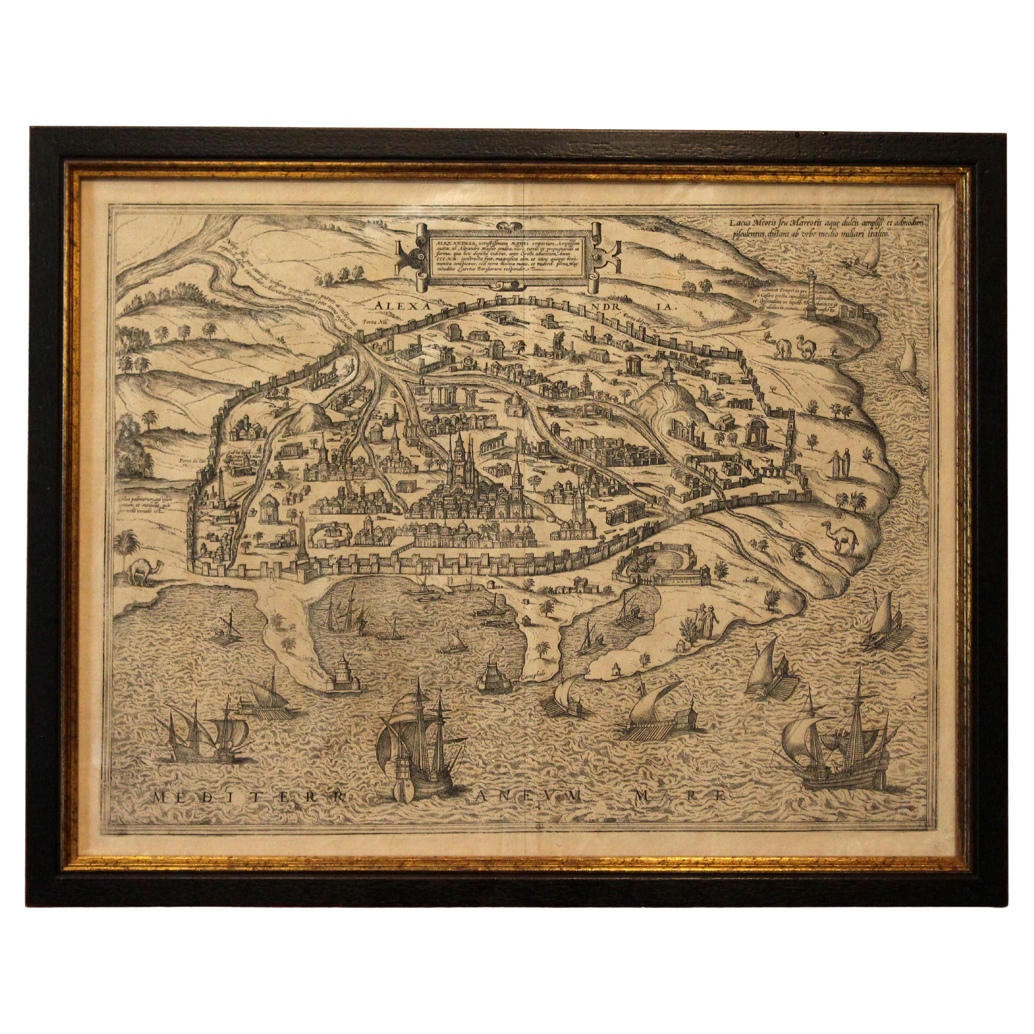
1597 German Map of Alexandria by Georg Braun and Frans Hogenberg
By Georg Braun and Frans Hogenberg
Located in Chapel Hill, NC
1597 Map of Alexandria by Georg Braun and Frans Hogenberg, Germany. From "Civitas Orbis Terrarum", part 2, published in Cologne by Bertram Buchholz. Printed in 2 parts. Title: "Alexa...
Category
Antique 16th Century German Renaissance Maps
Materials
Paper

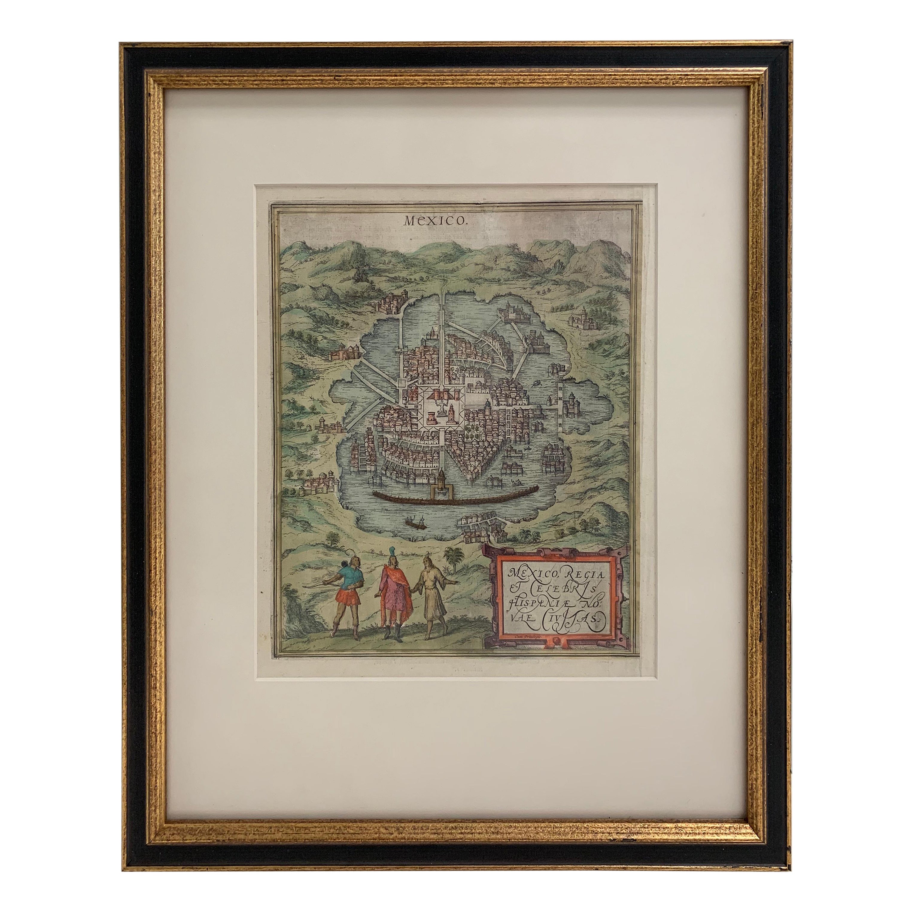
Mexico City by Braun & Hogenberg c. 1590
By Georg Braun and Frans Hogenberg
Located in Stamford, CT
Mexico by Braun & Hogenberg c. 1590
Category
Antique Mid-19th Century European Spanish Colonial Maps
Materials
Glass, Wood, Paper

Large Original Antique Map of Arkansas by Rand McNally, circa 1900
By Rand McNally & Co.
Located in St Annes, Lancashire
Fabulous monochrome map with red outline color
Original color
By Rand, McNally & Co.
Published, circa 1900
Unframed
Minor edge tears.
Category
Antique Early 1900s American Edwardian Maps
Materials
Paper

Original Antique Map of South Dakota by Rand McNally, circa 1900
By Rand McNally & Co.
Located in St Annes, Lancashire
Fabulous monochrome map with red outline color
Original color
By Rand, McNally & Co.
Published, circa 1900
Unframed
Minor edge tears.
Category
Antique Early 1900s American Edwardian Maps
Materials
Paper

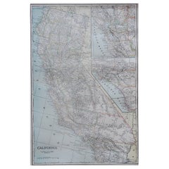
Large Original Antique Map of California, USA, circa 1900
Located in St Annes, Lancashire
Fabulous map of California
Original color
Engraved and printed by the George F. Cram Company, Indianapolis.
Published, circa 1900
Unframed
Free shipping.
Category
Antique 1890s American Maps
Materials
Paper
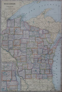
Large Original Antique Map of Wisconsin, USA, circa 1900
Located in St Annes, Lancashire
Fabulous map of Wisconsin
Original color
Engraved and printed by the George F. Cram Company, Indianapolis.
Published, circa 1900
Unframed
Category
Antique 1890s American Maps
Materials
Paper