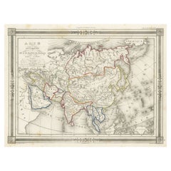
Antique Map of Asia, with Frame Style Border
View Similar Items


Want more images or videos?
Request additional images or videos from the seller
1 of 6
Auction endedBrowse Current Auctions
Antique Map of Asia, with Frame Style Border
About the Item
- Dimensions:Height: 10.12 in (25.7 cm)Width: 13.39 in (34 cm)Depth: 0.02 in (0.5 mm)
- Materials and Techniques:
- Period:
- Date of Manufacture:1852
- Condition:General age-related toning. Shows soiling and foxing, blank verso. Please study image carefully.
- Seller Location:Langweer, NL
- Reference Number:Seller: BG-13379-161stDibs: LU3054333360272
About the Seller
5.0
Platinum Seller
These expertly vetted sellers are 1stDibs' most experienced sellers and are rated highest by our customers.
Established in 2009
1stDibs seller since 2017
1,933 sales on 1stDibs
More From This SellerView All
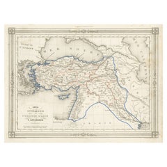
- Antique Map of Turkey in Asia, with Frame Style BorderLocated in Langweer, NLAntique map titled 'Asie Ottomane ou Turquie d'Asie'. Attractive map of Turkey in Asia. The map covers the Asian territories claimed by the Turkish Ottoman Empire c.1850 from the Bla...Category
Antique Mid-19th Century Maps
MaterialsPaper
 $146 Sale Price30% Off
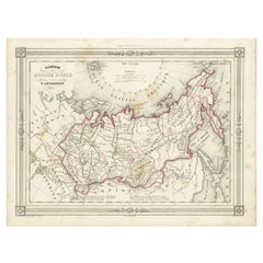
 - Antique Map of Russia in Asia and Siberia, with Frame Style BorderLocated in Langweer, NLAntique map titled 'Sibérie ou Russie d'Asie'. Attractive map of Russia in Asia and Siberia. This map originates from Maison Basset's 1852 edition of 'Atlas Illustre Destine a l'ense...Category
Antique Mid-19th Century Maps
MaterialsPaper
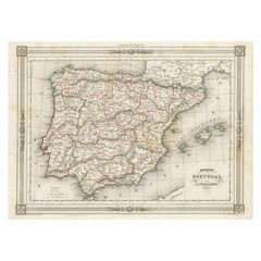
- Antique Map of Spain and Portugal, with Frame Style BorderLocated in Langweer, NLAntique map titled 'Espagne et Portugal'. Attractive map of Spain and Portugal. The map covers all of Spain and Portugal from France to the Mediterranean Sea and includes the Baleari...Category
Antique Mid-19th Century Maps
MaterialsPaper
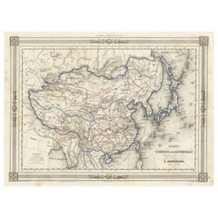
- Antique Map of China and Japan, with Frame Style BorderLocated in Langweer, NLAntique map titled 'Empires Chinois et Japonnais'. Attractive map of China and Japan. This map originates from Maison Basset's 1852 edition of 'Atlas Illustre Destine a l'enseignemen...Category
Antique Mid-19th Century Maps
MaterialsPaper
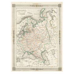
- Antique Map of Russia in Europe, with Frame Style BorderLocated in Langweer, NLAntique map titled 'Russie d'Europe'. Attractive map of Russia in Europe, covers the European portions of Russia from the Arctic Sea south to the Black Sea and Caspian Sea. This map ...Category
Antique Mid-19th Century Maps
MaterialsPaper
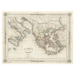
- Antique Map of Greece and Its Colonies, with Frame Style BorderLocated in Langweer, NLAntique map titled 'La Grèce'. Attractive map of Greece and its Colonies. The map covers from the southern part of Italy, including Sicily, to the western parts of Asia Minor and fro...Category
Antique Mid-19th Century Maps
MaterialsPaper
You May Also Like
- Antique Map of Principality of MonacoBy Antonio Vallardi EditoreLocated in Alessandria, PiemonteST/619 - "Old Geographical Atlas of Italy - Topographic map of ex-Principality of Monaco" - ediz Vallardi - Milano - A somewhat special edition ---Category
Antique Late 19th Century Italian Other Prints
MaterialsPaper
 $228 Sale Price74% Off
 - Large Antique 1859 Map of North AmericaLocated in Sag Harbor, NYThis Map was made by Augustus Mitchell in 1859 It is in amazing condition for being 163 years old. This price is for the rolled up easy to ship version of this piece. I will be Frami...Category
Antique Mid-19th Century American Maps
MaterialsCanvas, Paper

- Antique Map of Italy by Andriveau-Goujon, 1843By Andriveau-GoujonLocated in New York, NYAntique Map of Italy by Andriveau-Goujon, 1843. Map of Italy in two parts by Andriveau-Goujon for the Library of Prince Carini at Palazzo Carini i...Category
Antique 1840s French Maps
MaterialsLinen, Paper
 $3,350 / set
 - Forest Park Letter Pressed Map with Embossed Trails in Salvaged Fir FrameLocated in Portland, ORBeautiful Minimalist limited edition letter pressed topographic map of Portland's Forest Park with gold embossed hiking and running trails by designer Allison Bryan. Forest Park is on of the United State's largest urban forest reserves, and was developed by landscape designers John Charles Olmsted and his brother Frederick Law Olmsted...Category
2010s American Organic Modern Prints
MaterialsFir
- Hand-Colored 18th Century Homann Map of the Black Sea, Turkey and Asia MinorBy Johann Baptist HomannLocated in Alamo, CAAn attractive original early 18th century hand-colored map of the Black Sea and Turkey entitled "Carte de L'Asie Minevre ou de la Natolie et du Pont Evxin Tiree des Voyages et des Ob...Category
Antique Early 18th Century German Maps
MaterialsPaper
- Louisiana: A Framed 19th Century Map by O. W. GrayBy Gray and CoLocated in Alamo, CAThis framed 19th century map of the Louisiana territory was published in "Gray's Atlas of the United States with General Maps of the World, accompanied by Descriptions Geographical, Historical, Scientific and Statistica" published in 1873 in Philadelphia by O.W. Gray and Son and Stedman, Brown and Lyon. It is a highly detailed map of Louisiana...Category
Antique Mid-19th Century American Other Maps
MaterialsPaper


Recently Viewed
View AllMore Ways To Browse
Antique Map Bahamas
Antique Map Ontario
Antique Maps Ontario
Map Lebanon
Antique Map Montreal
Antique Maps San Diego
Lebanon Antique Map
Montreal Map
Antique Furniture Perth Australia
Antique Maps Perth
Barbados Map
Antique Map Connecticut
Antique Map Of Republic Of Texas
Antique Route 66
Giovanni Maria Cassini On Sale
Antique Map Cleveland
Antique Maps Washington Dc
Daniel Bautista