Items Similar to Antique Map of Brazil, Including Part of Colombia, Peru and Chili, c.1880
Want more images or videos?
Request additional images or videos from the seller
1 of 6
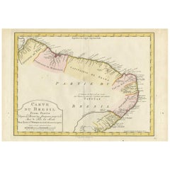
Antique Map of Brazil, Including Part of Colombia, Peru and Chili, c.1880
About the Item
Antique map South America titled 'Brazil'. This map depicts Brazil and its surroundings including part of Colombia, Peru and Chili. Source unknown, to be determined.
Artists and Engravers: Anonymous.
We sell original antique maps to collectors, historians, educators and interior decorators all over the world. Our collection includes a wide range of authentic antique maps from the 16th to the 20th centuries. Buying and collecting antique maps is a tradition that goes back hundreds of years. Antique maps have proved a richly rewarding investment over the past decade, thanks to a growing appreciation of their unique historical appeal. Today the decorative qualities of antique maps are widely recognized by interior designers who appreciate their beauty and design flexibility. Depending on the individual map, presentation, and context, a rare or antique map can be modern, traditional, abstract, figurative, serious or whimsical. We offer a wide range of authentic antique maps for any budget.
- Dimensions:Height: 16.54 in (42 cm)Width: 13.19 in (33.5 cm)Depth: 0 in (0.01 mm)
- Materials and Techniques:
- Period:
- Date of Manufacture:circa 1880
- Condition:Condition: Good, general age-related toning. Few tiny tears, please study image carefully.
- Seller Location:Langweer, NL
- Reference Number:
About the Seller
5.0
Platinum Seller
These expertly vetted sellers are 1stDibs' most experienced sellers and are rated highest by our customers.
Established in 2009
1stDibs seller since 2017
1,916 sales on 1stDibs
Typical response time: <1 hour
- ShippingRetrieving quote...Ships From: Langweer, Netherlands
- Return PolicyA return for this item may be initiated within 14 days of delivery.
More From This SellerView All
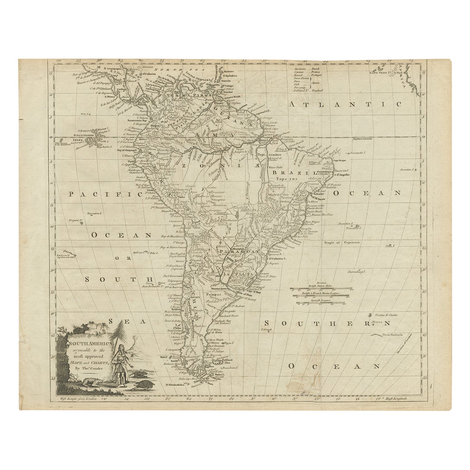
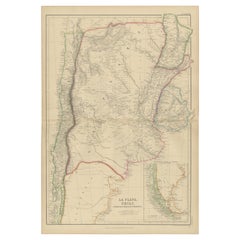
- Rare Map of South America of Chili, La Plata, Paraguay, Brazil, Peru, c.1775Located in Langweer, NLAntique map titled 'South America agreeable to the most approved maps and charts'. Rare map of South America depicting Chili, La Plata, Paraguay, Brazil, ...Category
Antique 1770s Maps
MaterialsPaper
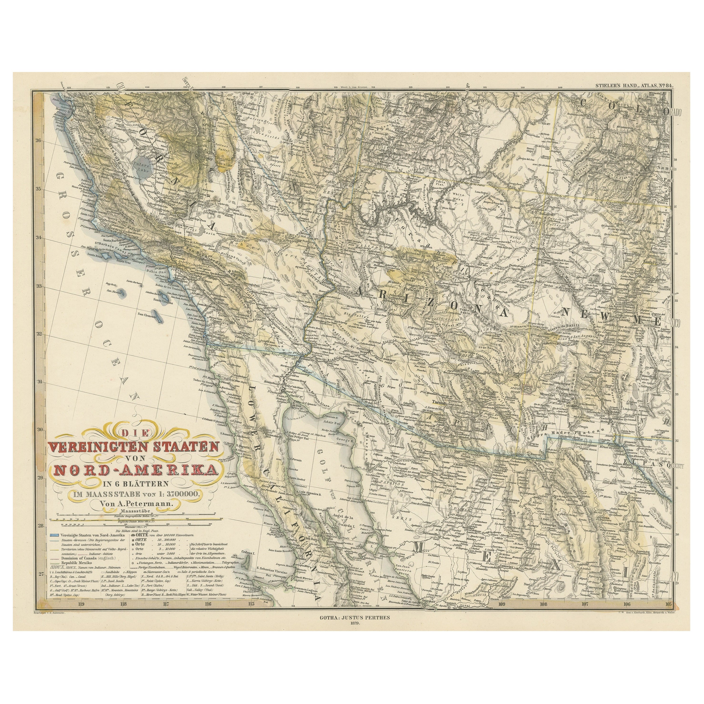
- Antique Map of Part of the United States Including Lower California & ArizonaLocated in Langweer, NLAntique map of part of the United States of America including Lower California, Arizona and part of Mexico. This map was part of a set of six individual sheets with maps of the Unite...Category
Antique Late 19th Century Maps
MaterialsPaper
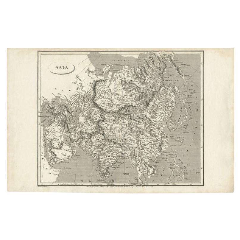
- Antique Map of Asia including Arabia, 1806Located in Langweer, NLAntique map titled 'Asia'. Original antique map of the Asian continent engraved by E. Jones. Artists and Engravers: Drawn under the direction of Mr. Arrowsmith. Published in 1806...Category
Antique 19th Century Maps
MaterialsPaper
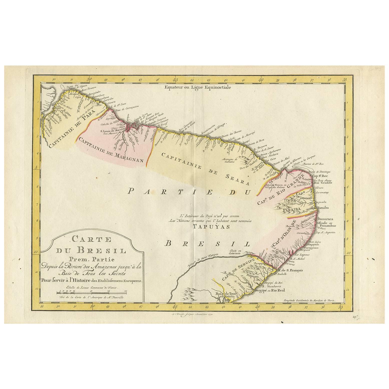
- Antique Map of the Eastern Part of Brazil by A. Van Krevelt, 1772Located in Langweer, NLRare edition of this accurate map of eastern part of Brazil. This map originates from 'Atlas Portatif pour servir a l'intelligence de l'Histoire Philosophique et Politique des etabli...Category
Antique Late 18th Century Maps
MaterialsPaper
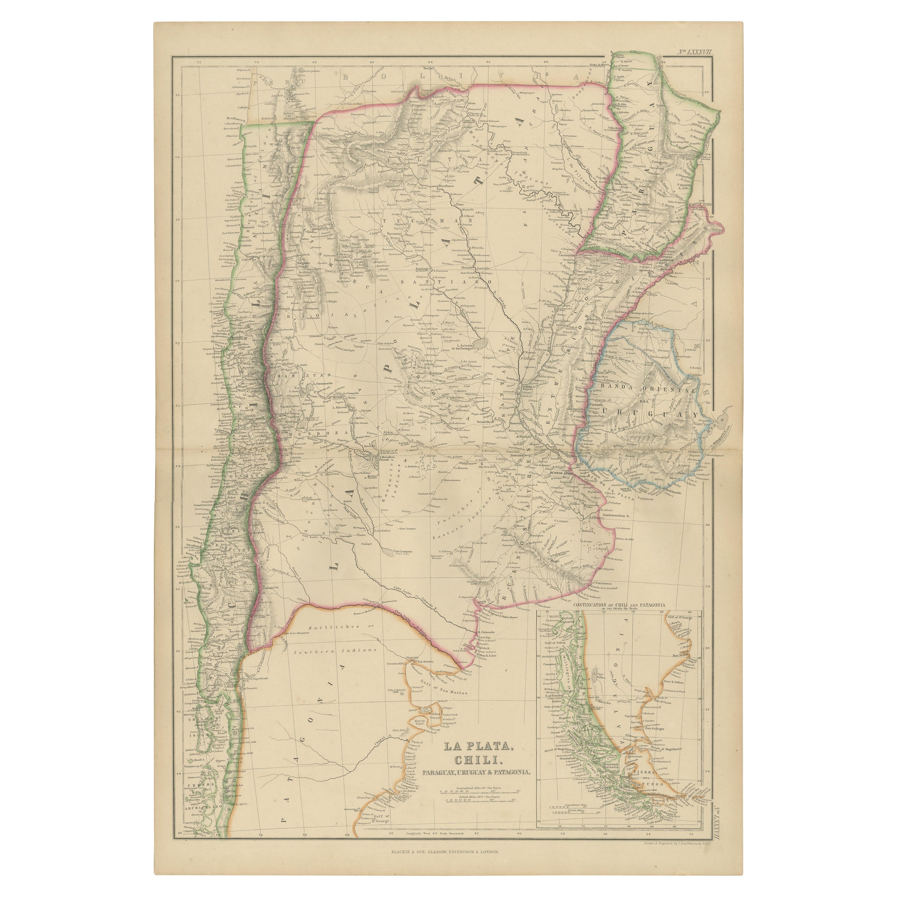
- Antique Map of La Plata, Chili, by W. G. Blackie, 1859Located in Langweer, NLAntique map titled 'La Plata, Chili, Paraguay, Uruguay and Patagonia'. Original antique map of La Plata, Chili, Paraguay, Uruguay and Patagonia with inset m...Category
Antique Mid-19th Century Maps
MaterialsPaper
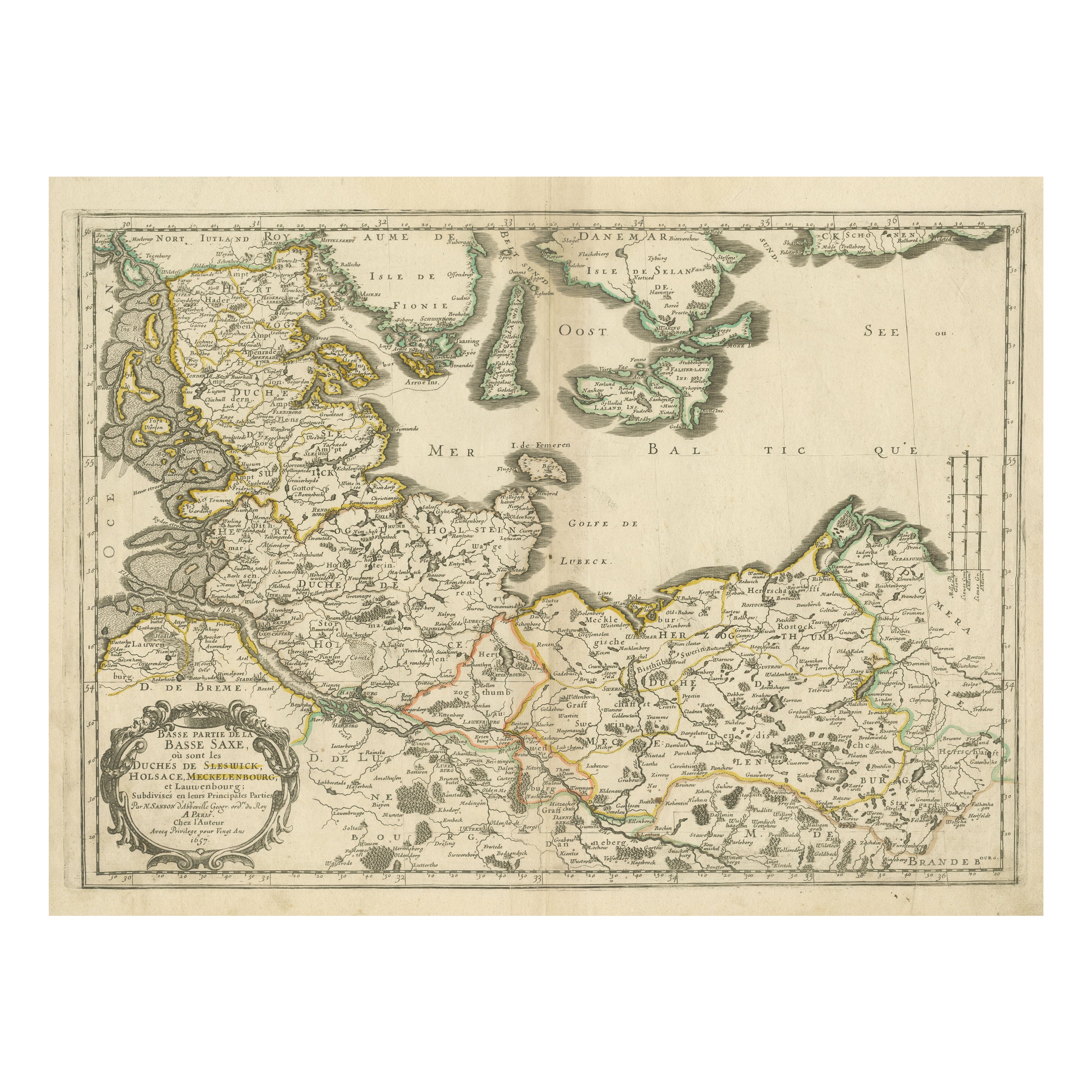
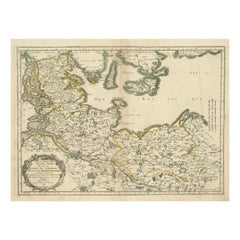
- Antique Map of Northern Germany, Including Schleswig-Holstein and HamburgLocated in Langweer, NLAntique map titled 'Basse Partie de la Basse Saxe ou sont les Duchés de Sleswick, Holsace, Meckelenbourg et Lauvenbourg (..)'. Original old map of northern Germany, including Schlesw...Category
Antique Mid-17th Century Maps
MaterialsPaper

You May Also Like
- 18th Century Hand-Colored Homann Map of Germany, Including Frankfurt and BerlinBy Johann Baptist HomannLocated in Alamo, CAAn 18th century hand-colored map entitled "Tabula Marchionatus Brandenburgici et Ducatus Pomeraniae quae sunt Pars Septentrionalis Circuli Saxoniae Superioris" by Johann Baptist Homa...Category
Antique Early 18th Century German Maps
MaterialsPaper
- Hand Colored 18th Century Homann Map of Austria Including Vienna and the DanubeBy Johann Baptist HomannLocated in Alamo, CA"Archiducatus Austriae inferioris" is a hand colored map of Austria created by Johann Baptist Homann (1663-1724) and published in Nuremberg, Germany in 1728 shortly after his death. ...Category
Antique Early 18th Century German Maps
MaterialsPaper
- Antique Map of Principality of MonacoBy Antonio Vallardi EditoreLocated in Alessandria, PiemonteST/619 - "Old Geographical Atlas of Italy - Topographic map of ex-Principality of Monaco" - ediz Vallardi - Milano - A somewhat special edition ---Category
Antique Late 19th Century Italian Other Prints
MaterialsPaper
- Original Antique Map of Spain and Portugal, circa 1790Located in St Annes, LancashireSuper map of Spain and Portugal Copper plate engraving by A. Bell Published, circa 1790. Unframed.Category
Antique 1790s English Other Maps
MaterialsPaper
- Original Antique Map of Ireland- Tipperary and Waterford. C.1840Located in St Annes, LancashireGreat map of Tipperary and Waterford Steel engraving Drawn under the direction of A.Adlard Published by How and Parsons, C.1840 Unframed.Category
Antique 1840s English Maps
MaterialsPaper
- Original Antique Map of Italy. C.1780Located in St Annes, LancashireGreat map of Italy Copper-plate engraving Published C.1780 Unframed.Category
Antique Early 1800s English Georgian Maps
MaterialsPaper


Recently Viewed
View AllMore Ways To Browse
Colombia Furniture
Brazilian Antiques
Brazil Antique
Antique Peruvian Furniture
Map South America
Antique Colombia
Map Of South America
Colombian Antique
Unknown Brazilian Designer
Antique Peru
Antique Furniture Peru
Peruvian Antiques
Antique Map South America
Antique Maps South America
South America Antique Map
Antique South America Map
Antique Map Of South America
Antique Maps Of South America