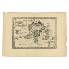
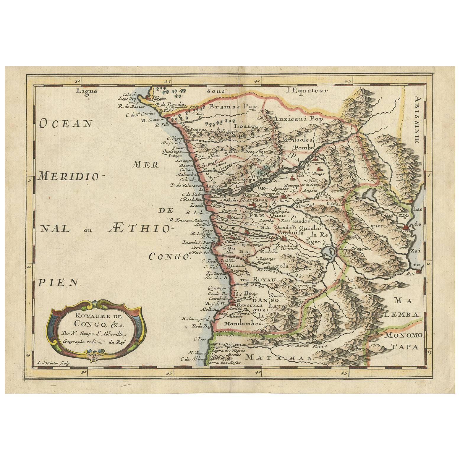
Antique Map of the Canary Islands by Sanson, 'circa 1705'
View Similar Items


Want more images or videos?
Request additional images or videos from the seller
1 of 5
Antique Map of the Canary Islands by Sanson, 'circa 1705'
About the Item
- Creator:Nicolas Sanson (Artist)
- Dimensions:Height: 10.63 in (27 cm)Width: 14.97 in (38 cm)Depth: 0.02 in (0.5 mm)
- Materials and Techniques:
- Period:
- Date of Manufacture:circa 1705
- Condition:Original folding line (small splits). General age-related toning, blank verso. Please study images carefully.
- Seller Location:Langweer, NL
- Reference Number:Seller: BG-12416-41stDibs: LU3054318531132
About the Seller
5.0
Platinum Seller
These expertly vetted sellers are 1stDibs' most experienced sellers and are rated highest by our customers.
Established in 2009
1stDibs seller since 2017
1,947 sales on 1stDibs
More From This SellerView All
- Antique Map of Asia by Sanson, circa 1705By Nicolas SansonLocated in Langweer, NLDutch edition of Sanson's map of Asia. Shows a large, dramatic version of Terre de Jesso, drawn from the discoveries of the Maarten de Vries expedition of 1643.Category
Antique Early 18th Century Dutch Maps
MaterialsPaper
- Antique Map of Russia by N. Sanson, 1705Located in Langweer, NLA strongly engraved map of European Russia showing its political divisions, major topographical features, cities and towns. Extends to the Sea of Azov and the tip of the Caspian Sea ...Category
Antique Early 18th Century Maps
MaterialsPaper
 $219 Sale Price33% Off
 - Antique Map of Madagascar by N. Sanson, circa 1680By Nicolas SansonLocated in Langweer, NLAntique map titled 'Isle de Madagascar ou de St. Laurens. Tiree de Sanutu &c'. Antique map of Madagascar, first published by Sanson in 1657. Sanson n...Category
Antique Late 17th Century Maps
MaterialsPaper
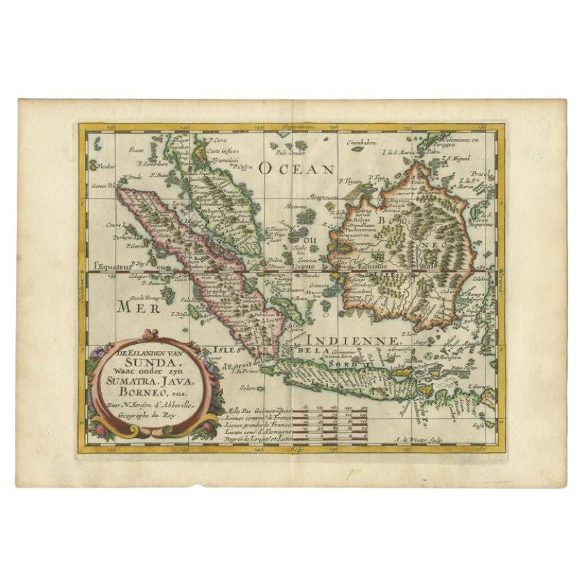
- Antique Map of the Bangka Belitun Island by Sanson, 1705Located in Langweer, NLAntique map Sunda Islands titled 'De Eilanden van Sunda, waar onder zyn Sumatra, Java, Borneo enz'. Old map of the Bangka Belitun Islands, part of the Greater Sunda Islands, includin...Category
Antique 18th Century Maps
MaterialsPaper
- Original Hand-coloured Antique Map of Pomerania by Sanson '1684'By Nicolas SansonLocated in Langweer, NLAntique map titled 'Le Duche de Pomeranie divise en ses Principales Parties (..)'. Large map of Pomerania. Pomerania is a historical region on the southern shore of the Baltic Sea in...Category
Antique Late 17th Century Maps
MaterialsPaper
 $835 Sale Price20% Off
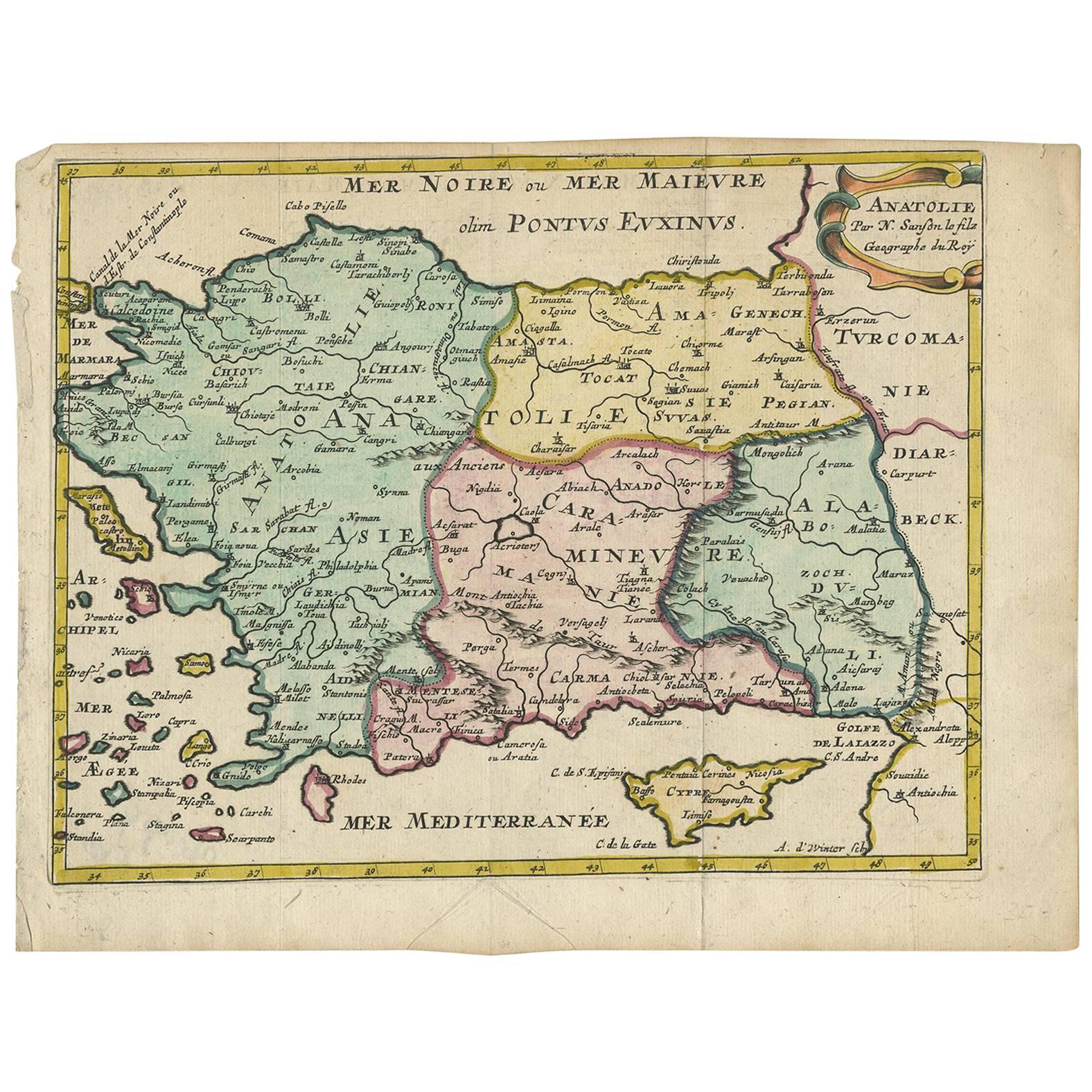
 - Antique Map of Turkey with Cyprus and Greece Islands by N. Sanson, circa 1652Located in Langweer, NLAntique map of Turkey, Anatolie with Cyprus and the Greece islands. Attractive scrolled title cartouche to top right corner. Blank verso.Category
Antique Mid-17th Century Maps
MaterialsPaper


You May Also Like
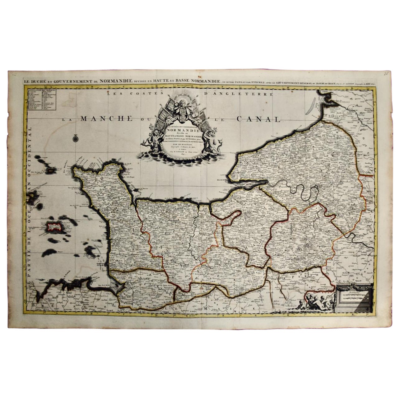
- The Normandy Region of France: A 17th C. Hand-colored Map by Sanson and JaillotBy Nicolas SansonLocated in Alamo, CAThis large hand-colored map entitled "Le Duché et Gouvernement de Normandie divisée en Haute et Basse Normandie en divers Pays; et par evêchez, avec le Gouvernement General du Havre ...Category
Antique 1690s French Maps
MaterialsPaper
- "Africa Vetus": a 17th Century Hand-Colored Map by SansonBy Nicolas SansonLocated in Alamo, CAThis original hand-colored copperplate engraved map of Africa entitled "Africa Vetus, Nicolai Sanson Christianiss Galliar Regis Geographi" was originally created by Nicholas Sanson d...Category
Antique Late 17th Century French Maps
MaterialsPaper
- 17th Century Map of Denmark by French Cartographer Sanson, Dated 1658By Nicolas SansonLocated in Copenhagen, K17th century map of Denmark by French cartographer Sanson. Nicolas Sanson (20 December 1600-7 July 1667) was a French cartographer, termed by some the creator of French geography an...Category
Antique 17th Century French Maps
MaterialsPaper
- Greece, "Graeciae Antiquae"" A 17th Century Hand-colored Map by SansonBy Nicolas SansonLocated in Alamo, CAThis is an original 17th century hand colored copperplate engraved map of Greece entitled "Graeciae Antiquae Tabula Hanc Geographicam" by Nicolas d'Abbeville Sanson, engraved and pub...Category
Antique Mid-17th Century French Maps
MaterialsPaper
- Portugal: A Large 17th Century Hand-colored Map by Sanson and JaillotBy Nicolas SansonLocated in Alamo, CAThis large hand-colored map entitled "Le Royaume de Portugal et des Algarves Divisee en see Archeveches, Eveches et Territoires Par le Sr Sanson" was originally created by Nicholas S...Category
Antique 1690s French Maps
MaterialsPaper
- Southern & Eastern Europe: A Large 17th C. Hand-colored Map by Sanson & JaillotBy Nicolas SansonLocated in Alamo, CAThis large hand-colored map entitled "Estats de L'Empire des Turqs en Europe, ou sont les Beglerbeglicz our Gouvernements" was originally created by Nicholas Sanson d'Abbeville and t...Category
Antique 1690s French Maps
MaterialsPaper


Recently Viewed
View AllMore Ways To Browse
Madeira Antique
Russian Collectable
Office World Map
Sea Collectables
Antique Curiosities Prints
Antique Appreciation
United States Map
Antique Collectible Plate
Prints Of Antique Maps
Antique Over A Hundred Years Old
Antique Furniture Plans
Antique Rare Maps
Rare Antique Maps
Original Antique World Map
Map Of United States
Antique German Collectible
Authentic Antique Maps
The United States Map