Items Similar to Antique Map of China, Tartary and Central Asia by Blaeu, c.1645


Want more images or videos?
Request additional images or videos from the seller
1 of 6
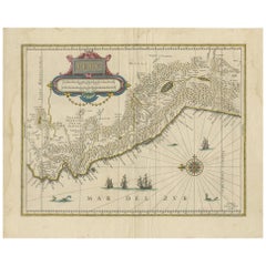
Antique Map of China, Tartary and Central Asia by Blaeu, c.1645
About the Item
Antique map titled ‘Tartaria sive Magnichami Imperiorum‘. Early map of Siberia based upon the journals of Marco Polo. The map covers from the Caspian Sea and the Volga River east as far as the China Sea and the city of Xanadu. It extends north to Nova Zembla and south to the Upper Ganges River. When Blaeu drew this map this part of the world was almost entirely unknown. Blaeu relied on the journals of Marco Polo to compile most of the map. Devils and dragons frolic in the Lop Nor and far to the north the summer seat of Kublai Khan's Yuan Empire Xanadu (Shangdu) is noted. The Great Wall of China appears prominently. Further west, the Geography becomes more stable with recognizable Silk Route centers such as Samarkand clearly identified. The title is set into a saddle blanket on the back of a dromedary. Mountains and forests are rendered pictorially. This map is distinguished from Jansson's very similar map by Blaeu's inclusion of degrees of longitude along the borders and meridians crossing the map.
Artists and Engravers: The Blaeu firm was founded in 1596 by Willem Janzoon Blaeu (1571-1638). It was in this initial period, from 1596 to 1672, under the leadership of the Willem Blaeu and with this assistance of his two talented sons Cornelius (1616-1648) and Johannis (1596-1673), that the firm was most active. Their greatest cartographic achievement was the publication of the magnificent multi-volume Atlas Major.
Condition: Very good. Light age-related toning and some creasing of the paper. Please study image carefully.
Date: c.1645
Overall size: 40 x 32.5 cm.
Image size: 35 x 27 cm.
We sell original antique maps to collectors, historians, educators and interior decorators all over the world. Our collection includes a wide range of authentic antique maps from the 16th to the 20th centuries. Buying and collecting antique maps is a tradition that goes back hundreds of years. Antique maps have proved a richly rewarding investment over the past decade, thanks to a growing appreciation of their unique historical appeal. Today the decorative qualities of antique maps are widely recognized by interior designers who appreciate their beauty and design flexibility. Depending on the individual map, presentation, and context, a rare or antique map can be modern, traditional, abstract, figurative, serious or whimsical. We offer a wide range of authentic antique maps for any budget.
- Dimensions:Height: 12.8 in (32.5 cm)Width: 15.75 in (40 cm)Depth: 0 in (0.01 mm)
- Materials and Techniques:Paper,Engraved
- Period:
- Date of Manufacture:circa 1645
- Condition:Condition: Very good. Light age-related toning and some creasing of the paper. Please study image carefully.
- Seller Location:Langweer, NL
- Reference Number:
About the Seller
5.0
Platinum Seller
These expertly vetted sellers are 1stDibs' most experienced sellers and are rated highest by our customers.
Established in 2009
1stDibs seller since 2017
1,928 sales on 1stDibs
Typical response time: <1 hour
- ShippingRetrieving quote...Ships From: Langweer, Netherlands
- Return PolicyA return for this item may be initiated within 14 days of delivery.
More From This SellerView All
- Antique Map of Central Sweden by J. Blaeu, 1662Located in Langweer, NLA striking, rare map with a cartouche dedicated to Gabriel Bengtsson Oxenstierna. Published by J. Bleau, Amsterdam, 1662. Contemporary coloring.Category
Antique Mid-17th Century Maps
MaterialsPaper
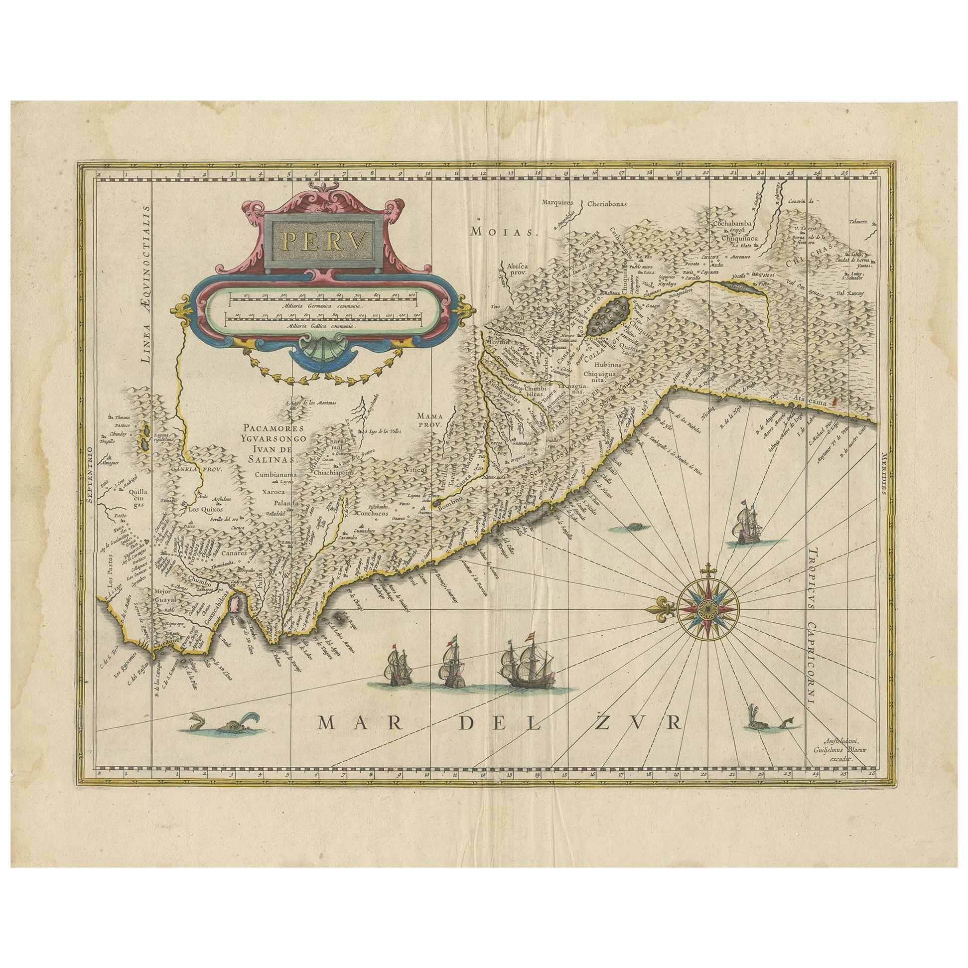
- Antique Map of Peru in South America by Blaeu, circa 1645Located in Langweer, NLAntique map titled 'Peru'. Original antique map of Peru. With cartouche, compass rose, ships and two sea-monsters. Published by W. Blaeu, circa 1645.Category
Antique Mid-17th Century Maps
MaterialsPaper
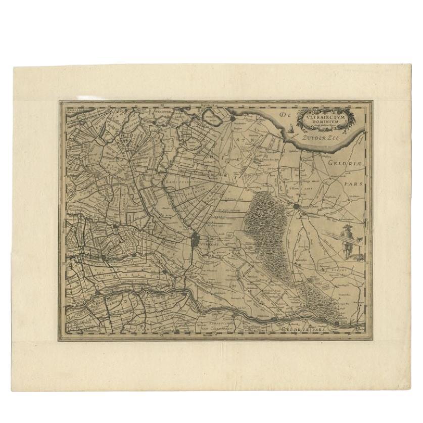
- Original Antique Map of Utrecht in the Netherlands by Blaeu, C.1645Located in Langweer, NLAntique map titled 'Ultraiectum Dominium'. Old map of the province of Utrecht, the Netherlands. This map originates from 'Theatrum Orbis Terrarum (..)'. Artists and Engravers: Wi...Category
Antique 17th Century Maps
MaterialsPaper
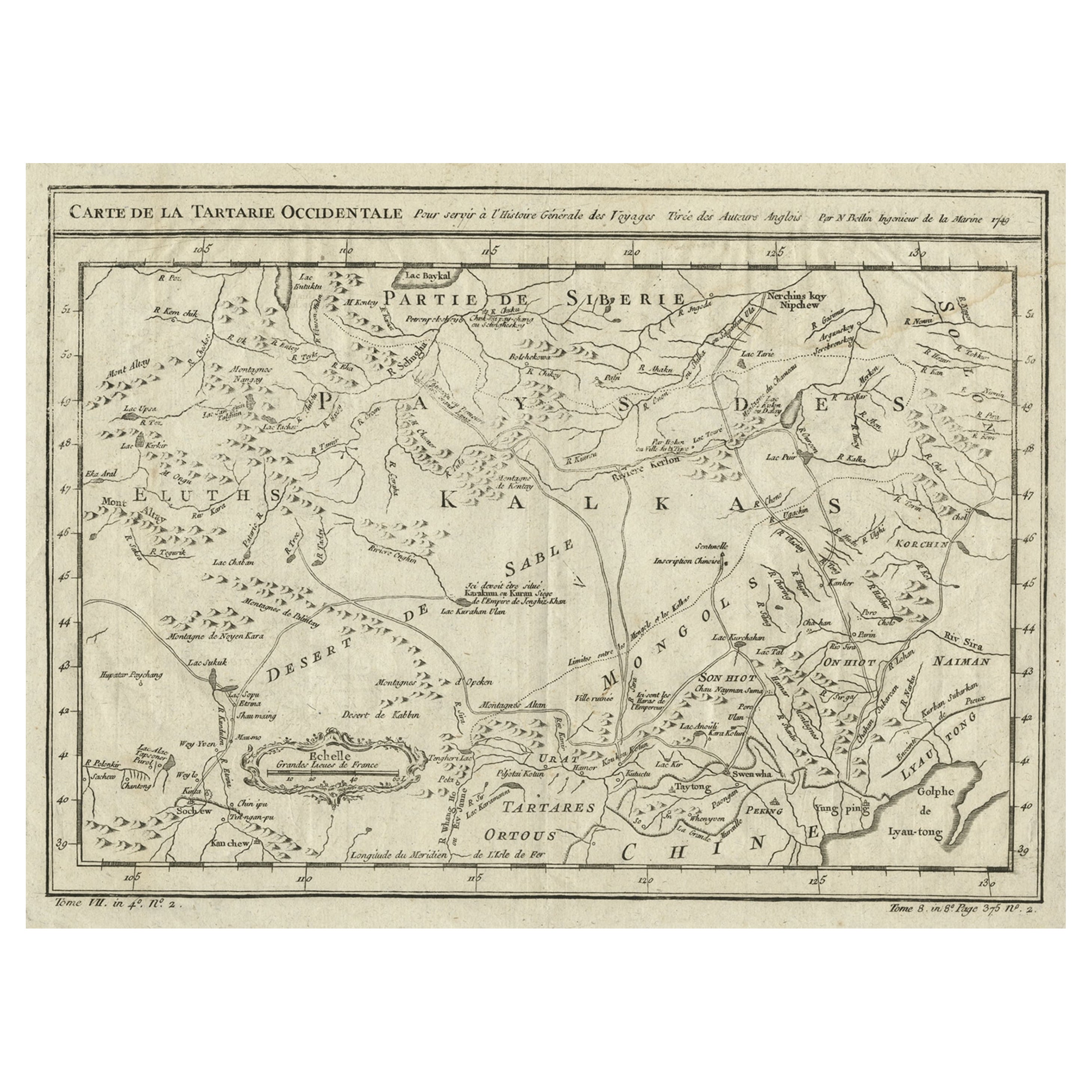
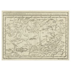
- Antique Map of Tartary and Northeast Asia, c.1750Located in Langweer, NLAntique map titled 'Carte de la tartarie occidentale'. An interesting map of Tartary and northeast Asia, from Lake Baykal, Partie du Siberia in the north, Pays des Kalkas at the cent...Category
Antique 18th Century Maps
MaterialsPaper
- Interesting Antique Map of Tartary and Northeast Asia, 1749Located in Langweer, NLCondition: Good, given age. Original folds, as issued. Some small water stains above image and top-right. Please study scan carefully.Category
Antique 1740s Maps
MaterialsPaper
- Original Antique Map of Zuid-Holland in the Netherlands by Blaeu, C.1645Located in Langweer, NLAntique map titled 'Zuydhollandia stricte sumta'. Old map of the province of Zuid-Holland, the Netherlands. This map originates from 'Theatrum Orbis Terrarum (..)'. Artists and E...Category
Antique 17th Century Maps
MaterialsPaper


You May Also Like
- Original Antique Map of Asia. C.1780Located in St Annes, LancashireGreat map of Asia Copper-plate engraving Published C.1780 Two small worm holes to right side of map Unframed.Category
Antique Early 1800s English Georgian Maps
MaterialsPaper

- Original Antique Map of Central America / Florida, Arrowsmith, 1820Located in St Annes, LancashireGreat map of Central America. Drawn under the direction of Arrowsmith. Copper-plate engraving. Published by Longman, Hurst, Rees, Orme and Brown, 1820 Unframed.Category
Antique 1820s English Maps
MaterialsPaper
- Original Antique Map of South East Asia by Becker, circa 1840Located in St Annes, LancashireGreat map of South East Asia Steel engraving with original color outline Engraved by Becker Published by Virtue, circa 1840. Unframed.Category
Antique 1840s English Other Maps
MaterialsPaper
- Original Antique Map of South East Asia by Thomas Clerk, 1817Located in St Annes, LancashireGreat map of South East Asia Copper-plate engraving Drawn and engraved by Thomas Clerk, Edinburgh. Published by Mackenzie And Dent, 1817 Unframed.Category
Antique 1810s English Maps
MaterialsPaper
- Original Antique Map of China by Thomas Clerk, 1817Located in St Annes, LancashireGreat map of China Copper-plate engraving Drawn and engraved by Thomas Clerk, Edinburgh. Published by Mackenzie And Dent, 1817 Unframed.Category
Antique 1810s English Maps
MaterialsPaper
- Original Antique Map of South East Asia, Arrowsmith, 1820Located in St Annes, LancashireGreat map of South East Asia Drawn under the direction of Arrowsmith Copper-plate engraving Published by Longman, Hurst, Rees, Orme and Brown, 1820 Unframed.Category
Antique 1820s English Maps
MaterialsPaper


