Items Similar to Antique Map of the Course of the Amazon River by E. Van Harrevelt, 1773


Want more images or videos?
Request additional images or videos from the seller
1 of 6
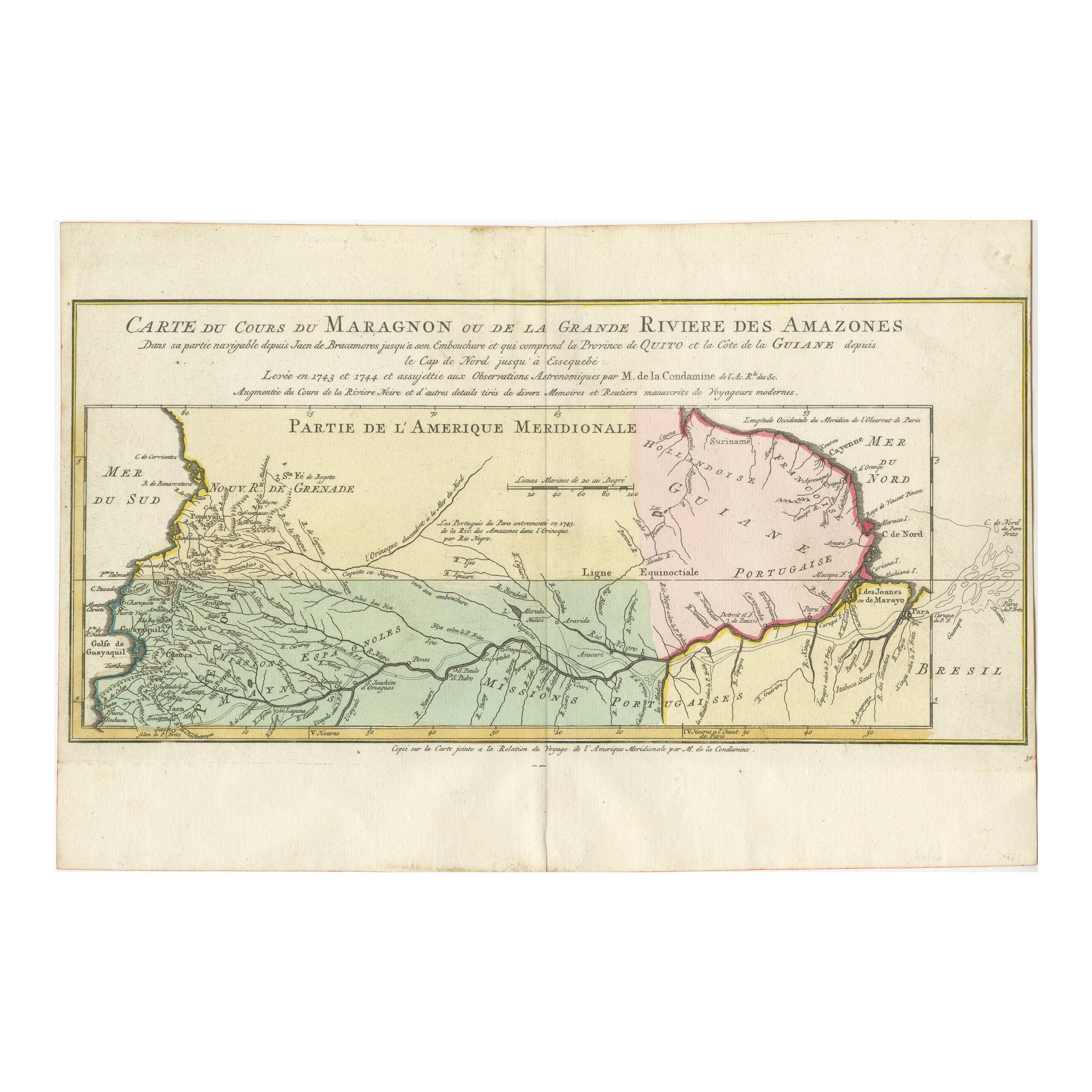
Antique Map of the Course of the Amazon River by E. Van Harrevelt, 1773
$330.86
$413.5720% Off
£245.78
£307.2220% Off
€276
€34520% Off
CA$459.43
CA$574.2920% Off
A$501.35
A$626.6820% Off
CHF 262.96
CHF 328.7020% Off
MX$6,089
MX$7,611.2520% Off
NOK 3,284.56
NOK 4,105.7120% Off
SEK 3,104.08
SEK 3,880.1020% Off
DKK 2,101.16
DKK 2,626.4520% Off
About the Item
Detailed regional map, showing the course of the Amazon River from the Andes to the Atlantic. This map originates from 'Atlas portatif pour servir à l'intelligence de l'histoire philosophique et politique des établissements et du commerce des Européens dans les Deux Indes (..)'. Amsterdam, E. van Harrevelt, D.J. Changuion, 1773.
- Dimensions:Height: 10.32 in (26.2 cm)Width: 15.28 in (38.8 cm)Depth: 0.02 in (0.5 mm)
- Materials and Techniques:
- Period:
- Date of Manufacture:1773
- Condition:Please study image carefully.
- Seller Location:Langweer, NL
- Reference Number:Seller: BG-034561stDibs: LU305439548373
About the Seller
5.0
Recognized Seller
These prestigious sellers are industry leaders and represent the highest echelon for item quality and design.
Platinum Seller
Premium sellers with a 4.7+ rating and 24-hour response times
Established in 2009
1stDibs seller since 2017
2,641 sales on 1stDibs
Typical response time: <1 hour
- ShippingRetrieving quote...Shipping from: Langweer, Netherlands
- Return Policy
Authenticity Guarantee
In the unlikely event there’s an issue with an item’s authenticity, contact us within 1 year for a full refund. DetailsMoney-Back Guarantee
If your item is not as described, is damaged in transit, or does not arrive, contact us within 7 days for a full refund. Details24-Hour Cancellation
You have a 24-hour grace period in which to reconsider your purchase, with no questions asked.Vetted Professional Sellers
Our world-class sellers must adhere to strict standards for service and quality, maintaining the integrity of our listings.Price-Match Guarantee
If you find that a seller listed the same item for a lower price elsewhere, we’ll match it.Trusted Global Delivery
Our best-in-class carrier network provides specialized shipping options worldwide, including custom delivery.More From This Seller
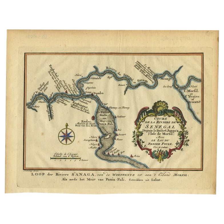
View AllMap of the Amazon River's Course and Surrounding Regions (1743-1744)
Located in Langweer, NL
This original antique map, titled "Carte du Cours du Maragnon ou de la Grande Riviere des Amazones," illustrates the course of the Amazon River (referred to here as the Maragnon) fro...
Category
Antique 1750s Maps
Materials
Paper

$374 Sale Price
29% Off
Antique Map of Northern Brazil by Bonne, c.1780
Located in Langweer, NL
Antique map titled 'Carte de la Partie Septentrionale du Bresil.' Detailed map of the northern portion of Brazil from Bahia to French Guiana, showing the eastern Amazon interior rivers, Mission Territories, Goyza and the coastal regions, including coastal currents. Source unknown, to be determined. Artists and Engravers: Rigobert Bonne (1727-1795 ) was one of the most important cartographers of the late 18th century. In 1773 he succeeded Jacques Bellin as Royal Cartographer to France in the office of the Hydrographer at the Depôt de la Marine. Working in his official capacity Bonne compiled some of the most detailed and accurate maps of the period. Bonne's work represents an important step in the evolution of the cartographic ideology away from the decorative work of the 17th and early 18th century towards a more detail oriented and practical aesthetic. With regard to the rendering of terrain Bonne maps...
Category
Antique 18th Century Maps
Materials
Paper

$119 Sale Price
20% Off
Antique Map of South America by J. Cook, 1775
Located in Langweer, NL
Antique map titled 'Kaart van het Zuidlyk Eind van Amerika'. Map of the sourthern part of South America, focusing on Cook's tracks around the Cape Horn and T...
Category
Antique Mid-18th Century Maps
Materials
Paper

$815 Sale Price
20% Off
Antique Map of South America Depicting Guayana, c.1780
Located in Langweer, NL
Antique map titled 'La Guyane Francopise avec partie de la Guyane Hollandoise: suivant les Operations et les Cartes recentes des Ingenieurs-Geographes Francois'. Antique map of South...
Category
Antique 18th Century Maps
Materials
Paper

$335 Sale Price
20% Off
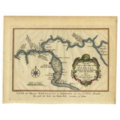
Antique Map of the Course of the Sanaga River by Van Schley, 1747
Located in Langweer, NL
Antique map titled 'Cours de la Riviere de Senegal (..) - Loop der Riviere Sanaga (..)'. Original antique map of the course of the Sanaga River that forms the border between Senegal ...
Category
Antique 18th Century Maps
Materials
Paper
$122 Sale Price
20% Off
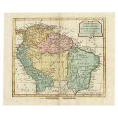
Antique Map of the Northern Part of South America by Delamarche, 1806
Located in Langweer, NL
Antique map titled 'Terre-Ferme, Perou, Bresil, Pays de L'Amazone.' This map shows the northern part of South America with Peru, Brazil, Guyana etc. By Robert de Vaugondy, revised an...
Category
Antique 19th Century Maps
Materials
Paper
$167 Sale Price
20% Off
You May Also Like
Original Antique Map of South America. C.1780
Located in St Annes, Lancashire
Great map of South America
Copper-plate engraving
Published C.1780
Two small worm holes to left side of map
Unframed.
Category
Antique Early 1800s English Georgian Maps
Materials
Paper

Early 19th Century Hand Coloured Map of North America by Aaron Arrowsmith
By Aaron Arrowsmith
Located in Hamilton, Ontario
Hand coloured map in French by English cartographer Aaron Arrowsmith (1750–1823) titled "Amerique Septentionale" (North America).
Map size: 9.5" x 8"
Mat size: 20.5" x 14.25".
Category
Antique Early 19th Century English Maps
Materials
Paper

$795 Sale Price
36% Off
Original Antique Map of Central America / Florida, Arrowsmith, 1820
Located in St Annes, Lancashire
Great map of Central America.
Drawn under the direction of Arrowsmith.
Copper-plate engraving.
Published by Longman, Hurst, Rees, Orme and Brown, 1820
Unframed.
Category
Antique 1820s English Maps
Materials
Paper

Original Antique Decorative Map of South America-West Coast, Fullarton, C.1870
Located in St Annes, Lancashire
Great map of Chili, Peru and part of Bolivia
Wonderful figural border
From the celebrated Royal Illustrated Atlas
Lithograph. Original color.
Published by Fullarton, Edi...
Category
Antique 1870s Scottish Maps
Materials
Paper

California: 18th Century Hand-colored Map by de Vaugondy
By Didier Robert de Vaugondy
Located in Alamo, CA
This is an 18th century hand-colored map of the western portions of North America entitled "Carte de la Californie et des Pays Nord-Ouest separés de l'Asie par le détroit d'Anian, ex...
Category
1770s Landscape Prints
Materials
Engraving

1654 Joan Blaeu Map the Sutherland, Scotland, Entitled "Southerlandia, "Ric0007
Located in Norton, MA
1654 Joan Blaeu map of the
Sutherland, Scotland, entitled
"Southerlandia,"
Hand Colored
Ric0007
Description:
Lovely map centered on Sedan and D...
Category
Antique 17th Century Dutch Maps
Materials
Paper

More Ways To Browse
Charles Rennie Mackintosh For Cassina
Glass Salt
Vintage Resin Tables
Antique English Country Furniture
Blue Kilim Vintage
Contemporary Side Tables And Stools
Decorative Wall Plate
Mid Century Modern Corner Chair
Dining Tables With Brass Inlay
Oak Mid Century Armchair
Solid Wood Side Table Stool
Antique Marble Top Hall Table
Bird And Butterfly
Old Carpet
Porcelain Modern Hand Painted
Bent Plywood
1960 Italian Dining Set
Italian Giltwood Table