Items Similar to Antique Map Covering Northern Italy, Austria, Slovenia & Croatia, ca.1690


Want more images or videos?
Request additional images or videos from the seller
1 of 6
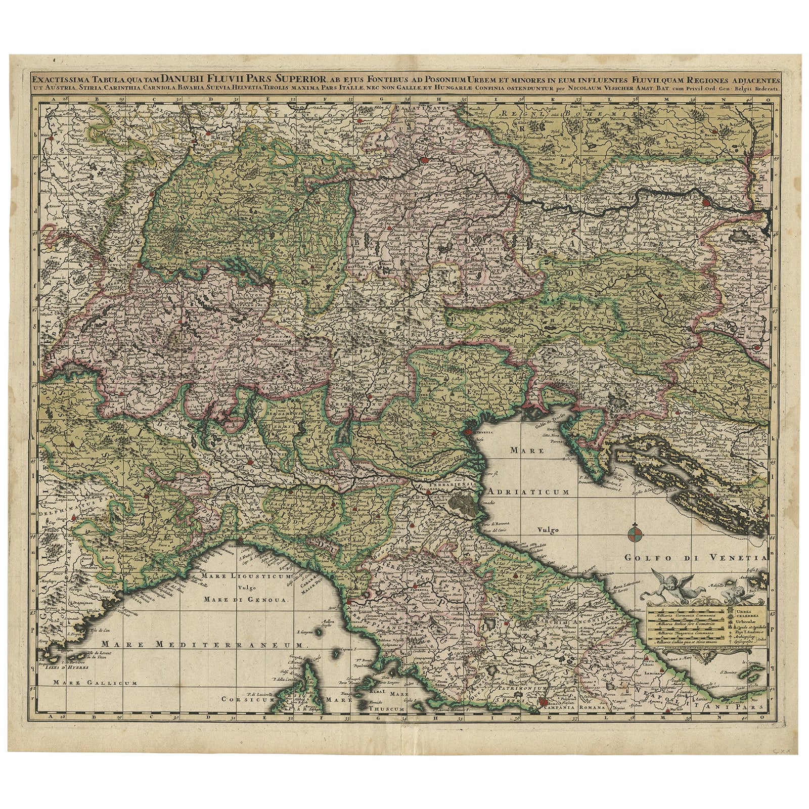
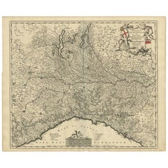
Antique Map Covering Northern Italy, Austria, Slovenia & Croatia, ca.1690
About the Item
Antique map titled 'Exactissima Tabula, qua tam Danubii Fluvii Pars Superior'.
Detailed map covering the region of northern Italy, Austria, Slovenia and Croatia. The course of the Danube is prominently shown from its headwaters in the Alps to its confluence with the Morava River.
Artists and Engravers: Nicolaes Visscher II (1649, Amsterdam – 1702, Amsterdam) was a Dutch engraver, cartographer and publisher. He was the son of Nicolaes Visscher I and the grandson of Claes Janszoon Visscher. After his death, his wife, Elisabeth, continued the family tradition of mapmaking and publishing. The works, engraved plates, were then sold to Peter Schenk, who also reprinted them.
Condition: Good, general age-related toning. Please study image carefully.
- Dimensions:Height: 21.07 in (53.5 cm)Width: 25.2 in (64 cm)Depth: 0 in (0.02 mm)
- Materials and Techniques:
- Period:1690-1699
- Date of Manufacture:circa 1690
- Condition:
- Seller Location:Langweer, NL
- Reference Number:
About the Seller
5.0
Platinum Seller
These expertly vetted sellers are 1stDibs' most experienced sellers and are rated highest by our customers.
Established in 2009
1stDibs seller since 2017
1,919 sales on 1stDibs
Typical response time: <1 hour
- ShippingRetrieving quote...Ships From: Langweer, Netherlands
- Return PolicyA return for this item may be initiated within 14 days of delivery.
More From This SellerView All
- Finely Detailed Map Covering Northern Italy, Austria, Slovenia & Croatia, c.1690Located in Langweer, NLAntique map titled 'Exactissima Tabula, qua tam Danubii Fluvii Pars Superior'. Very finely detailed map covering the region of northern Italy, Austria, Slovenia and Croatia. The ...Category
Antique 1690s Maps
MaterialsPaper
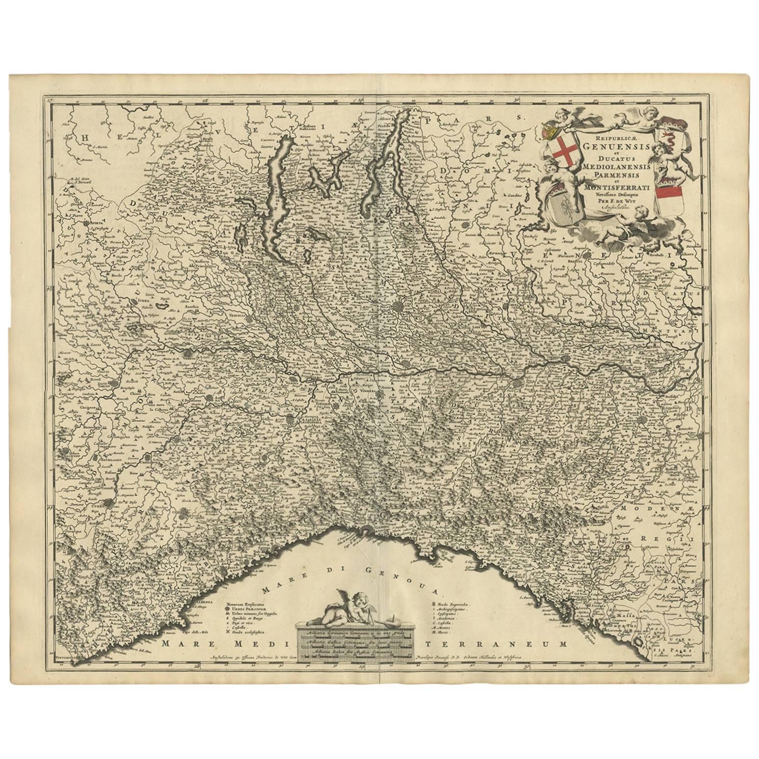
- Antique Map of Northern Italy by F. de Wit, 1690Located in Langweer, NLA very decorative map centered on Genua, and including the towns of Milan, Torino, Parma, Cremona, etc. Decorative title cartouche upper right, five putti holding the arms of the reg...Category
Antique Late 17th Century Maps
MaterialsPaper
- Antique Map of Austria by N. Visscher, circa 1690Located in Langweer, NLAntique map titled 'Austriae Archiducatus pars superior in omnes ejusdem'. Spectacular large map of Upper and Lower Austria between Passau and Wien with figurative cartouche and armo...Category
Antique Late 17th Century Maps
MaterialsPaper
- Antique Map of Austria by F. de Wit, 1690Located in Langweer, NLAntique map titled 'Circuli Austriaci pars Septentrionalis in qua Archiducatus'. Decorative and detailed map of Austria by F. de Wit.Category
Antique Late 17th Century Maps
MaterialsPaper
- Rare Antique Map of the Middle East, ca.1690Located in Langweer, NLDescription: Antique print, untitled. Two decorative maps on one sheet of the middle east in biblical times. Source unknown, to be determined. Artists and Engravers: Anonymous...Category
Antique 1690s Prints
MaterialsPaper
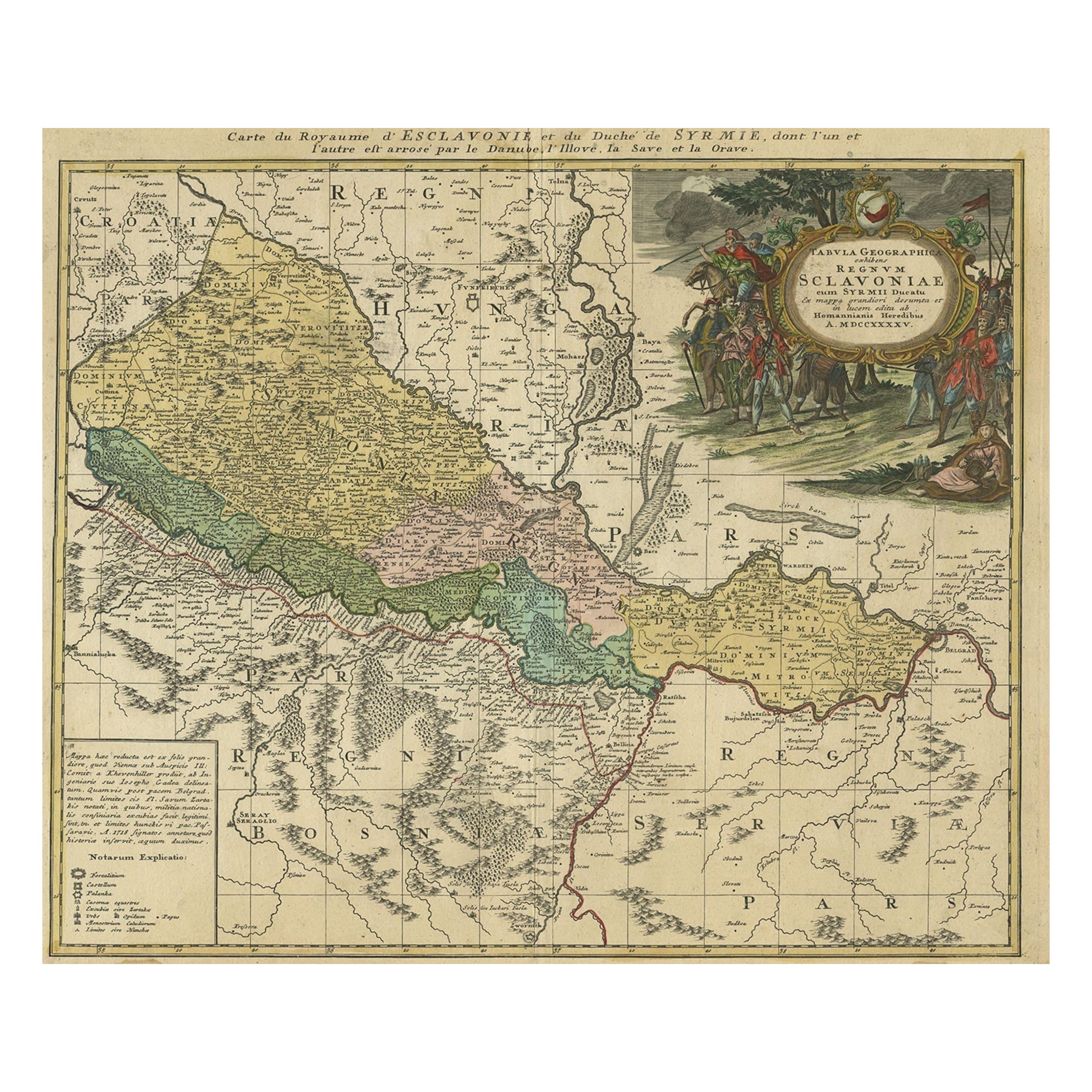
- Detailed Antique Map of Slavonia, the Region in Eastern Croatia, ca.1745Located in Langweer, NLAntique map titled 'Tabula Geographica exhibens Regnum Sclavoniae.' Detailed map of Slavonia, the region in eastern Croatia. Map is dated shortly after the Peace of Belgrade sign...Category
Antique 1740s Maps
MaterialsPaper


You May Also Like
- Hand-Colored 18th Century Homann Map of the Danube, Italy, Greece, CroatiaBy Johann Baptist HomannLocated in Alamo, CA"Fluviorum in Europa principis Danubii" is a hand colored map of the region about the Danube river created by Johann Baptist Homann (1663-1724) in his 'Atlas Novus Terrarum', publish...Category
Antique Early 18th Century German Maps
MaterialsPaper
- "Saint-Cloud Manufactory, ca 1690–1766", First EditionLocated in valatie, NYDiscovering the secrets of soft-paste porcelain at The Saint-Cloud Manufactory ca 1690-1766. North Haven: Yale University Press, 1999. First edition hardcover with dust jacket. 303 p...Category
Late 20th Century American Books
MaterialsPaper
- Original Antique Map of Italy. C.1780Located in St Annes, LancashireGreat map of Italy Copper-plate engraving Published C.1780 Unframed.Category
Antique Early 1800s English Georgian Maps
MaterialsPaper

- Large Antique Taxidermy of a Water Buffalo, Austria ca. 1900Located in Berghuelen, DELarge Antique Taxidermy of a Water Buffalo, Austria ca. 1900 A very large stuffed African water buffalo (Bubalus arnee) from a noble estate in A...Category
Early 20th Century Austrian Rustic Wall-mounted Sculptures
MaterialsWood, Antler
- Original Antique Map of Italy. Arrowsmith. 1820Located in St Annes, LancashireGreat map of Italy Drawn under the direction of Arrowsmith Copper-plate engraving Published by Longman, Hurst, Rees, Orme and Brown, 1820 Unframed.Category
Antique 1820s English Maps
MaterialsPaper
- Northern Scotland: A 16th Century Hand-colored Map by MercatorBy Gerard MercatorLocated in Alamo, CAA framed hand-colored 16th century map of Northern Scotland by Gerard Mercator entitled "Scotiae pars Septentrionalis", published in Amsterdam in 1636. It is a highly detailed map of the northern part of Scotland, with the northwest Highlands and the cities Inverness and Aberdeen, as well as the Orkney Islands and the Hebrides. There is a decorative title cartouche in the upper left corner. The map is presented in an antiqued brown wood...Category
Antique 16th Century Dutch Maps
MaterialsPaper


Recently Viewed
View AllMore Ways To Browse
Italy Map Antique
Antique Map Of Italy
Map Of Italy Antique
Antique Maps Of Italy
Tam Tam
Austrian Alps
Austria Alps
Map Austria
Map Of Austria
Antique Map Of Northern Italy
Antique Map Schenk
Visscher Amsterdam
Croatian Artist
Elisabeth Of Austria
Elisabeth Ii
Antique Map Of Austria
Danube River
Croatia Antique Map