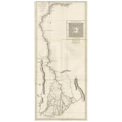
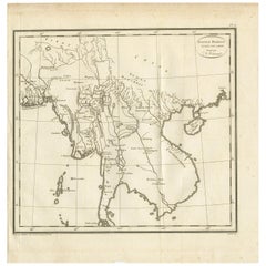
Antique Map of the Irrawaddy or Ayeyarwady River by Symes, 1800
View Similar Items


Want more images or videos?
Request additional images or videos from the seller
1 of 5
Antique Map of the Irrawaddy or Ayeyarwady River by Symes, 1800
About the Item
- Dimensions:Height: 37.41 in (95 cm)Width: 17.33 in (44 cm)Depth: 0.02 in (0.5 mm)
- Materials and Techniques:
- Period:
- Date of Manufacture:1800
- Condition:General age-related toning, original folding line. Few small defects on folding lines. Minor wear, blank verso. Please study image carefully.
- Seller Location:Langweer, NL
- Reference Number:Seller: BG-12359-21stDibs: LU3054320940792
About the Seller
5.0
Recognized Seller
These prestigious sellers are industry leaders and represent the highest echelon for item quality and design.
Platinum Seller
Premium sellers with a 4.7+ rating and 24-hour response times
Established in 2009
1stDibs seller since 2017
2,439 sales on 1stDibs
Typical response time: 1 hour
Authenticity Guarantee
In the unlikely event there’s an issue with an item’s authenticity, contact us within 1 year for a full refund. DetailsMoney-Back Guarantee
If your item is not as described, is damaged in transit, or does not arrive, contact us within 7 days for a full refund. Details24-Hour Cancellation
You have a 24-hour grace period in which to reconsider your purchase, with no questions asked.Vetted Professional Sellers
Our world-class sellers must adhere to strict standards for service and quality, maintaining the integrity of our listings.Price-Match Guarantee
If you find that a seller listed the same item for a lower price elsewhere, we’ll match it.Trusted Global Delivery
Our best-in-class carrier network provides specialized shipping options worldwide, including custom delivery.More From This Seller
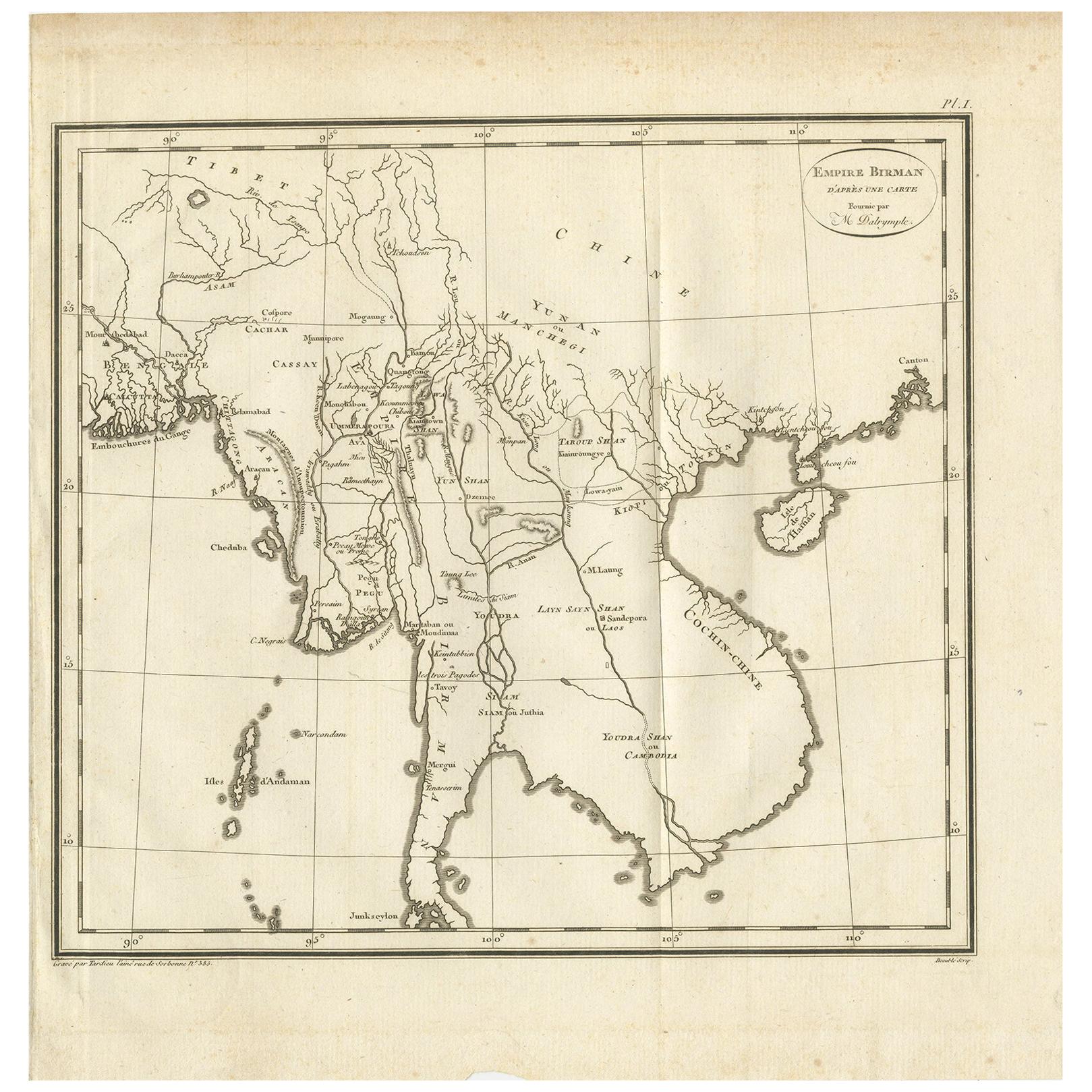
View AllAntique Map of the Burmese Empire by Symes, '1800'
Located in Langweer, NL
Antique map titled 'Empire Birman d'après une carte'. Map of the Burmese Empire. This map originates from 'Relation de l'Ambassade Anglaise, envoyée en 1795 dans le Royaume d'Ava, ou...
Category
Antique Early 19th Century Maps
Materials
Paper
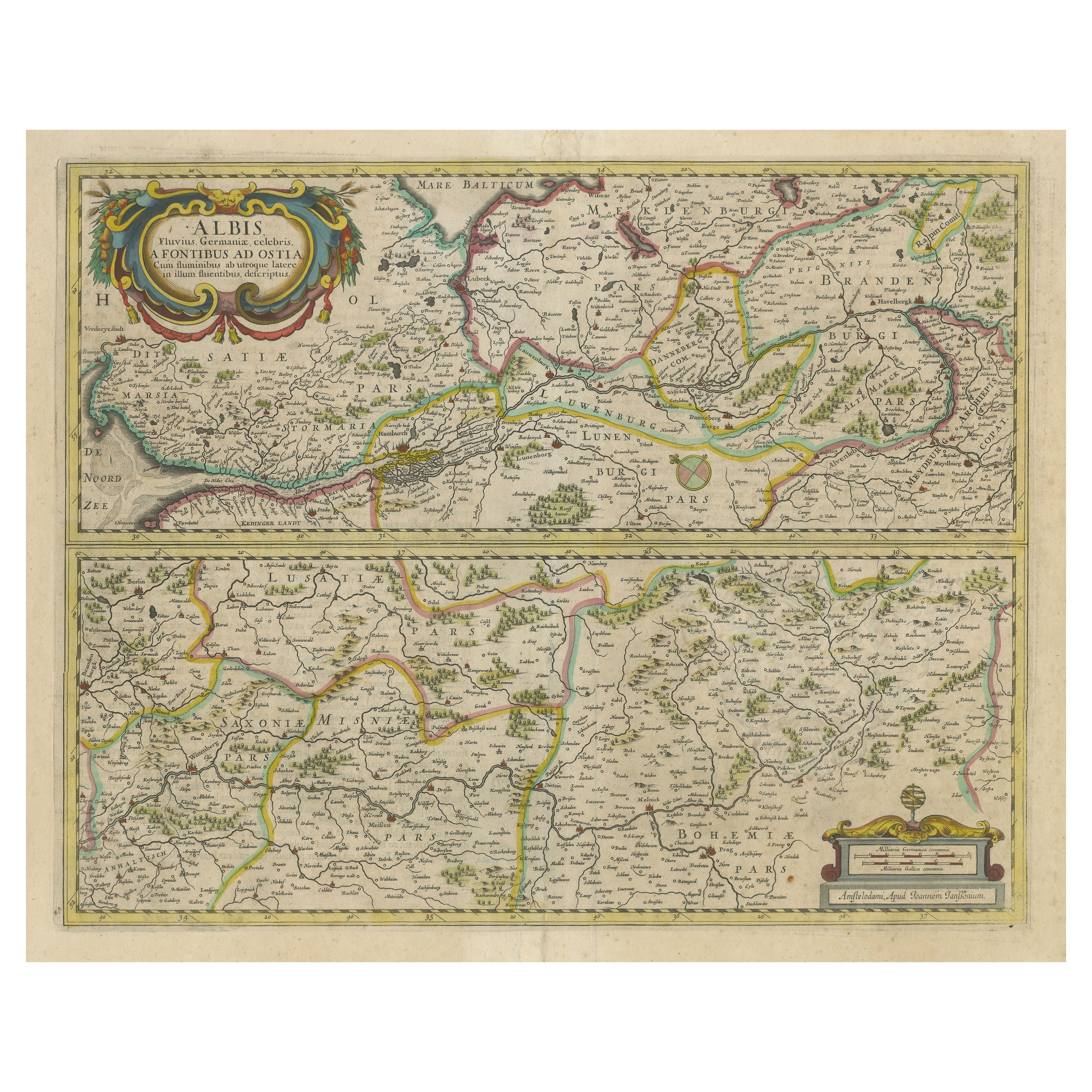
Antique Map of the of the Course of the Albis River 'or Elbe River'
By Johannes Janssonius
Located in Langweer, NL
Antique map titled 'Albis Fluvius Germaniae celebris A Fontiubus Ad Ostia, Cum Fluminibus ab utroque latere in illum fluenibus descriptus'. Detailed map of the course of the Albis Ri...
Category
Antique Mid-17th Century Maps
Materials
Paper
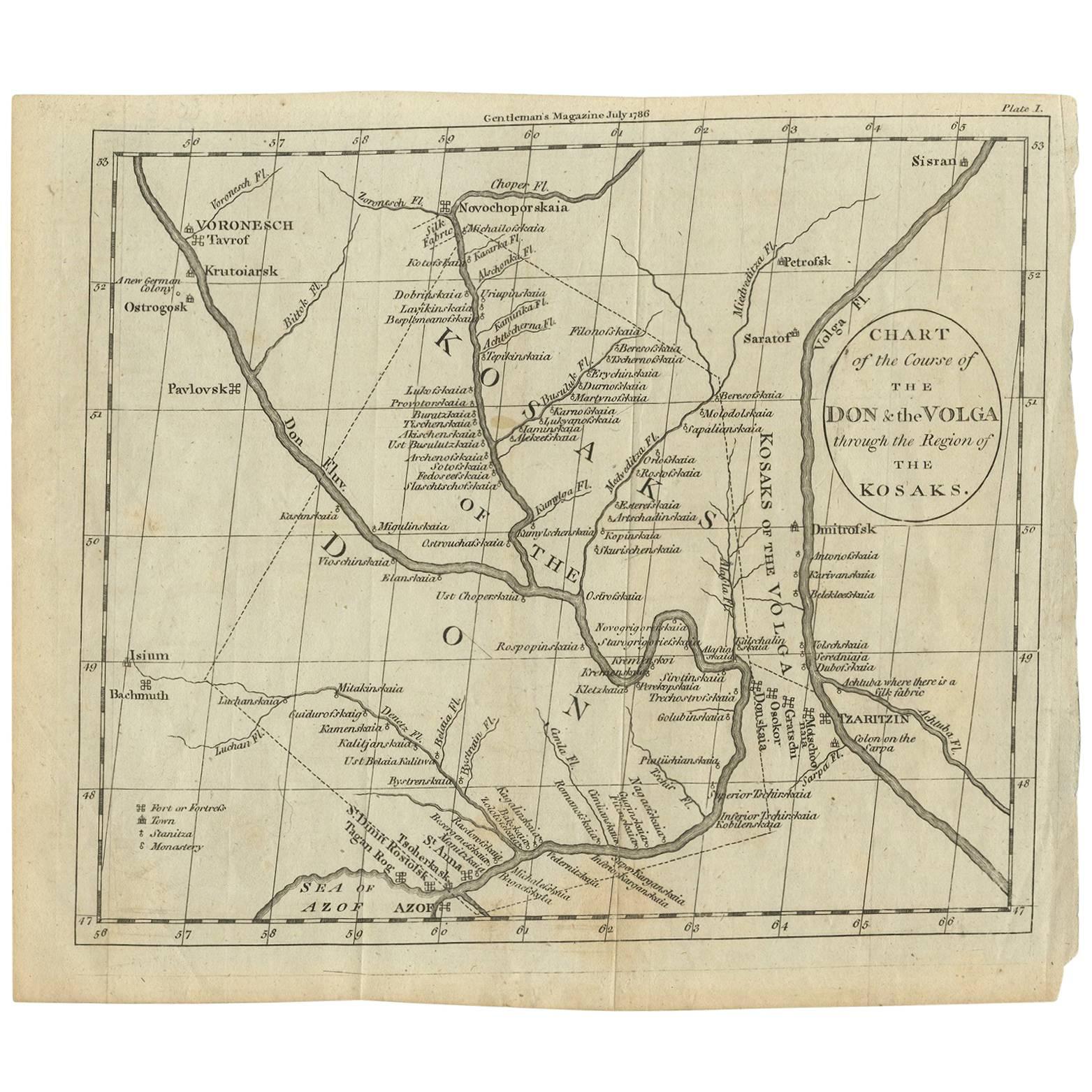
Antique Map of the course of the Don & Voga rivers
Located in Langweer, NL
Antique map titled 'Chart of the Course of The Don & the Volga through the Region of The Kosaks'. SW Russia & Ukraine: interesting map showing the course of th...
Category
Antique Late 18th Century Maps
Materials
Paper
$133 Sale Price
20% Off
Antique Map of Egypt and the Nile River
Located in Langweer, NL
Antique map titled 'Egypten nach dem Zustand der alten Zeit vorgestellt'. This uncommon and richly detailed map of Egypt features hundreds of place names along the Nile. The Sinai Pe...
Category
Antique Mid-18th Century Maps
Materials
Paper

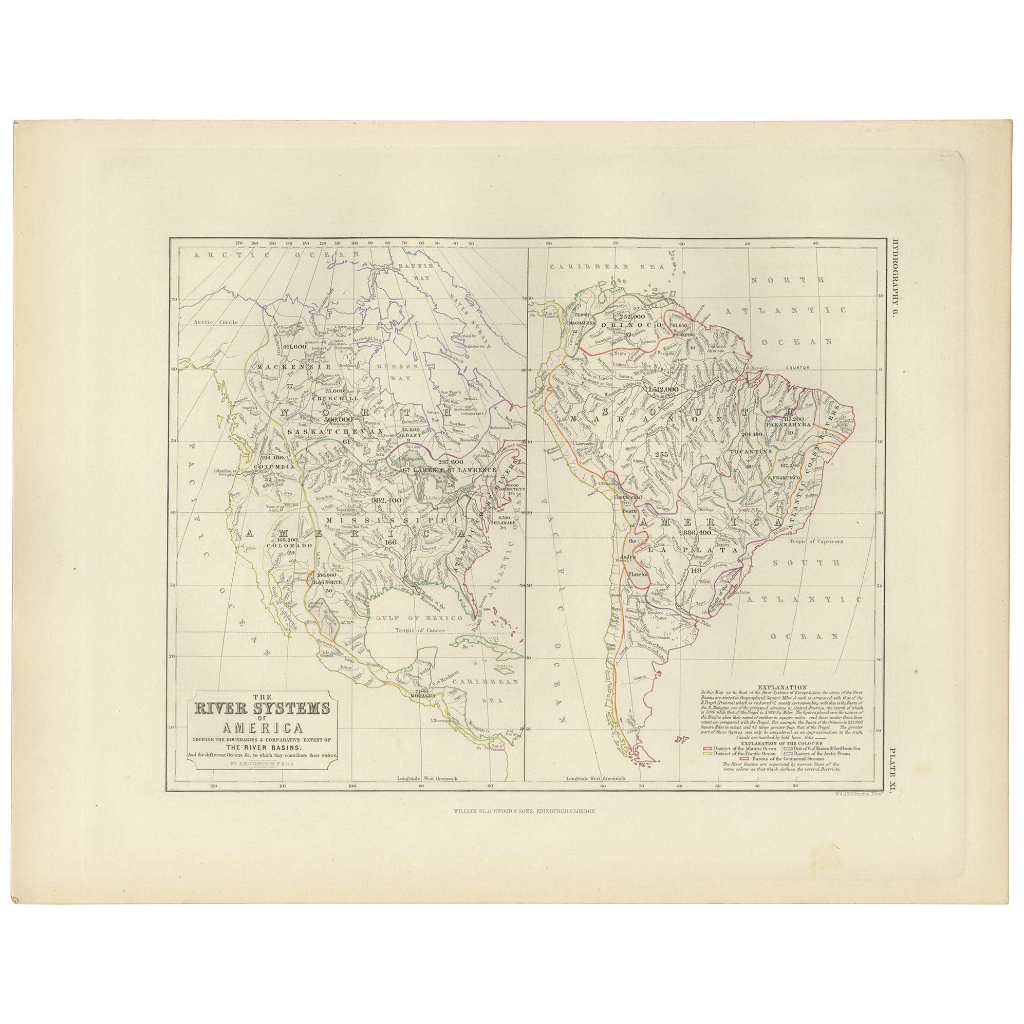
Antique Map of the River Systems of America by Johnston, '1850'
Located in Langweer, NL
Antique map titled 'The River Systems of America showing the boundaries and comparative extent of the river basins'. Original antique map of the river systems of America. This map or...
Category
Antique Mid-19th Century Maps
Materials
Paper
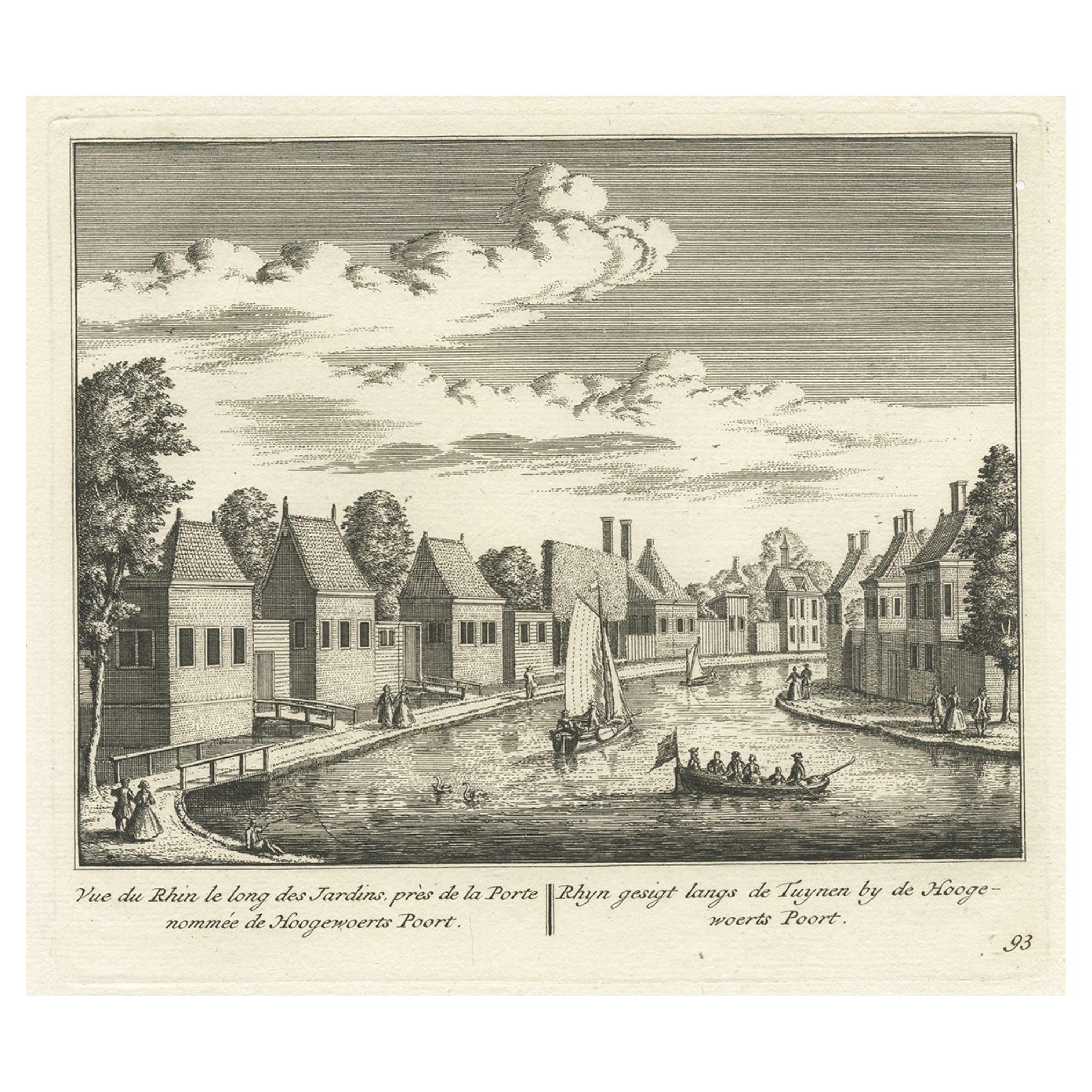
Antique Print of the Rhine River, Leiden, The Netherlands, c.1800
Located in Langweer, NL
Antique print titled 'Rhyn gesigt langs de Tuynen by de Hoogewoerts Poort'. Old print depicting with a view on the Rhine river, the Netherlands. This print...
Category
Antique 18th Century Prints
Materials
Paper
$156 Sale Price
20% Off
You May Also Like
Original Antique Map of The World by Thomas Clerk, 1817
Located in St Annes, Lancashire
Great map of The Eastern and Western Hemispheres
On 2 sheets
Copper-plate engraving
Drawn and engraved by Thomas Clerk, Edinburgh.
Published by Mackenzie And Dent, 1817
...
Category
Antique 1810s English Maps
Materials
Paper

Map of the Republic of Genoa
Located in New York, NY
Framed antique hand-coloured map of the Republic of Genoa including the duchies of Mantua, Modena, and Parma.
Europe, late 18th century.
Dimension: 25...
Category
Antique Late 18th Century European Maps

Antique Map of Italy by Andriveau-Goujon, 1843
By Andriveau-Goujon
Located in New York, NY
Antique Map of Italy by Andriveau-Goujon, 1843. Map of Italy in two parts by Andriveau-Goujon for the Library of Prince Carini at Palazzo Carini i...
Category
Antique 1840s French Maps
Materials
Linen, Paper

$3,350 / set
Antique Map of Principality of Monaco
By Antonio Vallardi Editore
Located in Alessandria, Piemonte
ST/619 - "Old Geographical Atlas of Italy - Topographic map of ex-Principality of Monaco" -
ediz Vallardi - Milano -
A somewhat special edition ---
Category
Antique Late 19th Century Italian Other Prints
Materials
Paper

Antique 18th Century Map of the Province of Pensilvania 'Pennsylvania State'
Located in Philadelphia, PA
A fine antique of the colony of Pennsylvania.
Noted at the top of the sheet as a 'Map of the province of Pensilvania'.
This undated and anonymous map is thought to be from the Gentleman's Magazine, London, circa 1775, although the general appearance could date it to the 1760's.
The southern boundary reflects the Mason-Dixon survey (1768), the western boundary is placed just west of Pittsburgh, and the northern boundary is not marked.
The map has a number of reference points that likely refer to companion text and appear to be connected to boundaries. The western and southern boundaries are marked Q, R, S, for example. A diagonal line runs from the Susquehanna R to the Lake Erie P. A broken line marked by many letters A, B, N, O, etc., appears in the east.
There are no latitude or longitude markings, blank verso.
Framed in a shaped contemporary gilt wooden frame and matted under a cream colored matte.
Bearing an old Graham Arader Gallery...
Category
Antique 18th Century British American Colonial Maps
Materials
Paper

Map "Estuary- Mouth of the Thames"
Located in Alessandria, Piemonte
ST/426 - Antique French Map of the estuary of the Thames, map dated 1769 -
"Mape of the entrance of the Thames. Designed by filing of Navy cards fo...
Category
Antique Mid-18th Century French Other Prints
Materials
Paper
