Items Similar to Antique Map of the Island Java, Indonesia, c.1650


Want more images or videos?
Request additional images or videos from the seller
1 of 5
Antique Map of the Island Java, Indonesia, c.1650
$3,092.92
$3,866.1620% Off
£2,291.31
£2,864.1420% Off
€2,600
€3,25020% Off
CA$4,254.14
CA$5,317.6720% Off
A$4,731.82
A$5,914.7820% Off
CHF 2,482.31
CHF 3,102.8820% Off
MX$57,738.97
MX$72,173.7120% Off
NOK 31,156.09
NOK 38,945.1120% Off
SEK 29,360.83
SEK 36,701.0420% Off
DKK 19,796.06
DKK 24,745.0720% Off
About the Item
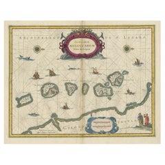
Antique map titled 'Insulae Iavae cum parte insularum Boreno Sumatrae (..)'.
Beautiful map of the island of Java and part of Borneo, Bali, Madura and Sumatra. With decorative cartouches featuring natives and Chinese merchants flanking the title and Neptune and mermaids surrounding the scale of miles. Artists and Engravers: Jan Janssonius (also known as Johann or Jan Jansson or Janszoon) (1588-1664) was a renowned geographer and publisher of the seventeenth century, when the Dutch dominated map publishing in Europe. Born in Arnhem, Jan was first exposed to the trade via his father, who was also a bookseller and publisher. In 1612, Jan married the daughter of Jodocus Hondius, who was also a prominent mapmaker and seller. Jonssonius first maps date from 1616.
Artist: Jan Janssonius (also known as Johann or Jan Jansson or Janszoon) (1588-1664) was a renowned geographer and publisher of the seventeenth century, when the Dutch dominated map publishing in Europe. Born in Arnhem, Jan was first exposed to the trade via his father, who was also a bookseller and publisher. In 1612, Jan married the daughter of Jodocus Hondius, who was also a prominent mapmaker and seller. Jonssonius? first maps date from 1616.
Condition: Good, general age-related toning. Original/contemporary hand coloring. Small repair on folding line, blank verso. Please study image carefully.
Date: c.1650
Overall size: 61.5 x 54 cm.
Image size: 51 x 41 cm.
- Dimensions:Height: 24.22 in (61.5 cm)Width: 21.26 in (54 cm)Depth: 0 in (0.01 mm)
- Materials and Techniques:
- Period:
- Date of Manufacture:circa 1650
- Condition:Condition: Good, general age-related toning. Original/contemporary hand coloring. Small repair on folding line, blank verso. Please study image carefully.
- Seller Location:Langweer, NL
- Reference Number:Seller: BGJC-3691stDibs: LU3054326361712
About the Seller
5.0
Recognized Seller
These prestigious sellers are industry leaders and represent the highest echelon for item quality and design.
Platinum Seller
Premium sellers with a 4.7+ rating and 24-hour response times
Established in 2009
1stDibs seller since 2017
2,593 sales on 1stDibs
Typical response time: <1 hour
- ShippingRetrieving quote...Shipping from: Langweer, Netherlands
- Return Policy
Authenticity Guarantee
In the unlikely event there’s an issue with an item’s authenticity, contact us within 1 year for a full refund. DetailsMoney-Back Guarantee
If your item is not as described, is damaged in transit, or does not arrive, contact us within 7 days for a full refund. Details24-Hour Cancellation
You have a 24-hour grace period in which to reconsider your purchase, with no questions asked.Vetted Professional Sellers
Our world-class sellers must adhere to strict standards for service and quality, maintaining the integrity of our listings.Price-Match Guarantee
If you find that a seller listed the same item for a lower price elsewhere, we’ll match it.Trusted Global Delivery
Our best-in-class carrier network provides specialized shipping options worldwide, including custom delivery.More From This Seller
View AllAntique Map of Java and Part of Borneo, Indonesia, c.1657
Located in Langweer, NL
Antique map titled 'Insulae Iavae cum parte insularum Boreno Sumatrae (..)'.
Beautiful map of the island of Java and part of Borneo, Bali, Madura and Sumatra. With decorative carto...
Category
Antique 17th Century Maps
Materials
Paper

$2,617 Sale Price
20% Off
Antique Map of Java in The Dutch East Indies, Now Indonesia, c.1690
Located in Langweer, NL
Antique map titled 'Insulae Iavae cum parte insularum Boreno Sumatrae (..)'.
Beautiful map of the Island of Java and part of Borneo, Bali, Madura and Sumatra. Artists and Engrave...
Category
Antique 17th Century Maps
Materials
Paper

$2,617 Sale Price
20% Off
Antique Map of Java by Janssonius, circa 1650
Located in Langweer, NL
Antique map titled 'Insulae Iavae cum parte insularum Borneo Sumatrae, et circumjacentium insularum novissima delineatio'. Beautiful map of Java and parts of Bali, Borneo, Sumatra an...
Category
Antique Mid-17th Century Maps
Materials
Paper

Antique Map of Java and Madura Island, Indonesia, c.1760
Located in Langweer, NL
Antique map titled 'Idee de l'Isle de Java.'
Well engraved and attractive chart of the island shows all principal harbors and coastal details, plus rivers, mountains and volcanoe...
Category
Antique 18th Century Maps
Materials
Paper

$428 Sale Price
20% Off
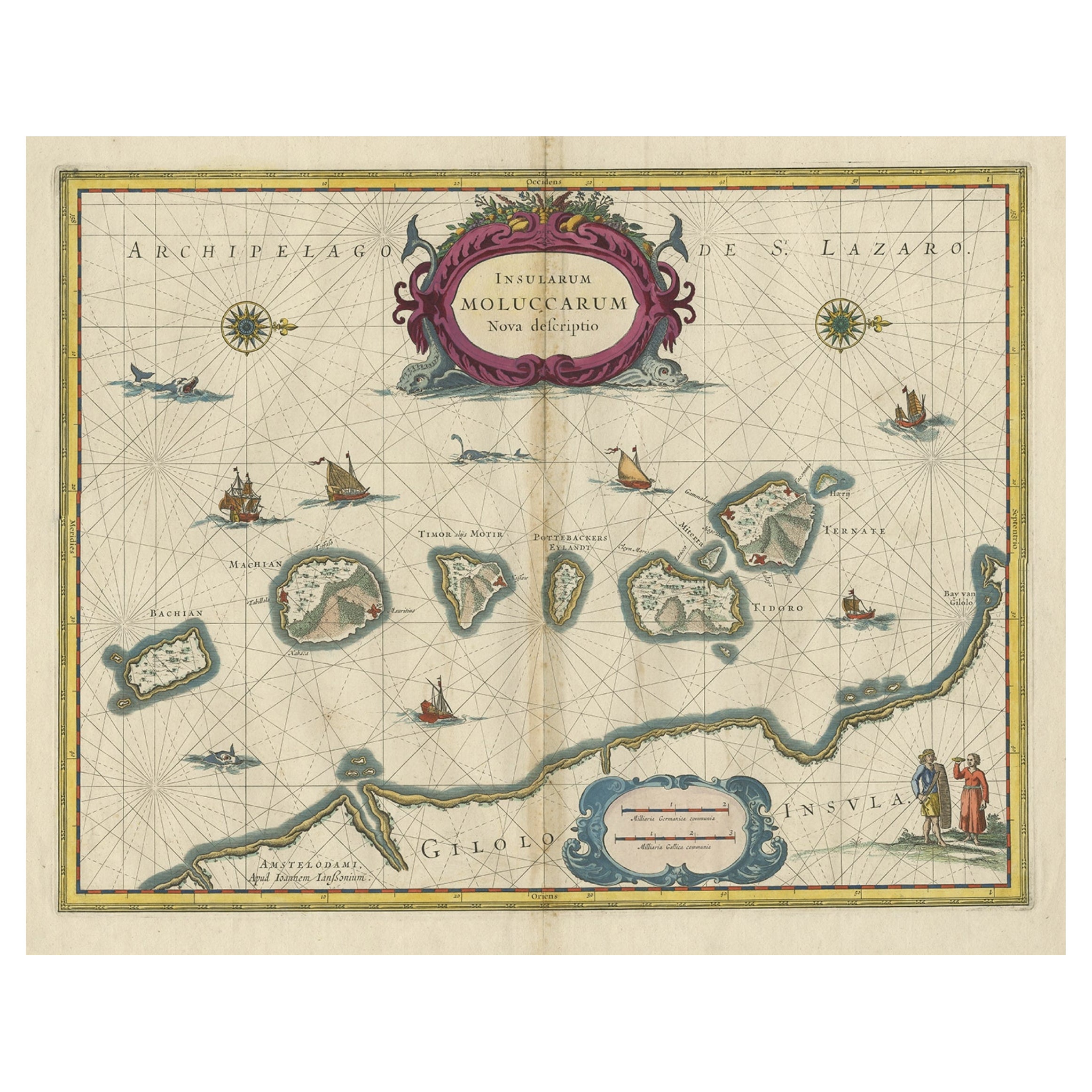
Beautiful Antique Map of the Moluccas or Spice Islands, Indonesia, ca.1650
Located in Langweer, NL
Antique map titled 'Insularum Moluccarum Nova Descriptio.'
Beautiful map of the Moluccas. The famous Spice Islands, the cornerstone of the Dutc...
Category
Antique 1650s Maps
Materials
Paper
$704 Sale Price
20% Off
Old Antique Map of the East Indies and Southeast Asia, ca.1644
Located in Langweer, NL
Antique map titled 'India quae Orientalis dicitur, et Insulae adiacentes'.
Old map of the East Indies and Southeast Asia showing the area between India in the West and parts of Japan, the Marianas and New Guinea/Australia in the East. This map is dedicated to D. Christophorus Thisius by Henricus...
Category
Antique 1640s Dutch Maps
Materials
Paper

$2,364 Sale Price
25% Off
You May Also Like
Antique French Map of Asia Including China Indoneseia India, 1783
Located in Amsterdam, Noord Holland
Very nice map of Asia. 1783 Dedie au Roy.
Additional information:
Country of Manufacturing: Europe
Period: 18th century Qing (1661 - 1912)
Condition: Overall Condition B (Good Used)...
Category
Antique 18th Century European Maps
Materials
Paper

$648 Sale Price
20% Off
Antique Map - Mare Pacificum - Etching by Johannes Janssonius - 1650s
By Johannes Janssonius
Located in Roma, IT
Mare Pacificum is an antique map realized in 1650 by Johannes Janssonius (1588-1664).
The Map is Hand-colored etching, with coeval watercolorang.
Good conditions with slight foxing...
Category
1650s Modern Figurative Prints
Materials
Etching

Antique Map - Gallia - Etching by Johannes Janssonius - 1650s
By Johannes Janssonius
Located in Roma, IT
Antique Map - Gallia is an antique map realized in 1650 by Johannes Janssonius (1588-1664).
The Map is Hand-colored etching, with coeval watercoloring.
Good conditions with slight ...
Category
1650s Modern Figurative Prints
Materials
Etching

1627 Hendrik Hondius Map Entitled "Vltoniae Orientalis Pars, " Ric.a009
Located in Norton, MA
1627 Hendrik Hondius map entitled
"Vltoniae orientalis pars,"
Ric.a009
Title:
Vltoniae orientalis : pars
Title (alt.) :
Ultoniae orientalis pars
Creator:
Mercator, Gerh...
Category
Antique 17th Century Dutch Maps
Materials
Paper

Ancient Map - Zeilan - Etching by Johannes Janssonius - 1650s
By Johannes Janssonius
Located in Roma, IT
Ancient Map - Zeilan is an ancient map realized in 1650 by Johannes Janssonius (1588-1664).
The Map is Hand-colored etching, with coeval watercoloring.
...
Category
1650s Modern Figurative Prints
Materials
Etching

Antique Map - Mar Di Athiopia - Etching by Johannes Janssonius - 1650s
By Johannes Janssonius
Located in Roma, IT
Antique Map - Mar Di Athiopia is an antique map realized in 1650 by Johannes Janssonius (1588-1664).
The Map is Hand-colored etching, with coeval watercolorang.
Good conditions wit...
Category
1650s Modern Figurative Prints
Materials
Etching

More Ways To Browse
Indonesian Antiques
Jans Antiques
Bali Map
Caribbean Colonial Furniture
Antique Maps West Indies
California Island Map
Pirate Antique
Map Of Holy Land
Antique Blackwood Furniture
Antique Macedonia
Antique Maps Of New York City
Victorian Compass
Antique Maps Caribbean Islands
Hungary Map
Cartographer Tool
Goa Furniture
George Fleet
Sri Lanka Map