Items Similar to Antique Map of Singapore, Malaysia, Borneo, Sumatra and Java (Indonesia), 1739

Want more images or videos?
Request additional images or videos from the seller
1 of 6
Antique Map of Singapore, Malaysia, Borneo, Sumatra and Java (Indonesia), 1739
About the Item
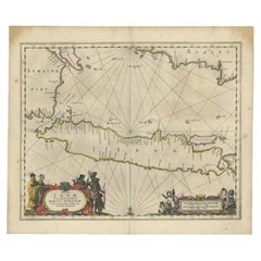
"Antique map titled 'Nieuwe kaart van de Sundasche Eilanden als Borneo, Sumatra en Groot Iava & c'. Detailed map of Southeast Asia, extending from the tip of Cambodia to Java. This map originates from: 'Hedendaagsche Historie, of tegenwoordige staat van alle volkeren... II deel...', published by Isaak Tirion, Amsterdam, 1739 ed. (originally published 1730). This is in fact an amended Dutch edition of: 'Modern History: or the Present State of all Nations.', published by Thomas Salmon since 1725. German, Italian and Dutch editions were published as well. This monumental Dutch edition, translated by M. van Gogh and published by Isaac Tirion, was much amended and enlarged into a 39 volume series. This plate originates from the second volume from this series which deals with: Java, Sumatra, Siam, Kochin and Tonkin. Artists and Engravers: Published by I. Tirion, Amsterdam.
Artist: Published by I. Tirion, Amsterdam.
Condition: Very good, defect left margin. Please study image carefully.
Date: 1739
Overall size: 39.5 x 31 cm.
Image size: 37 x 28.5 cm.
Antique prints have long been appreciated for both their aesthetic and investment value. They were the product of engraved, etched or lithographed plates. These plates were handmade out of wood or metal, which required an incredible level of skill, patience and craftsmanship. Whether you have a house with Victorian furniture or more contemporary decor an old engraving can enhance your living space. We offer a wide range of authentic antique prints for any budget.".
- Dimensions:Height: 12.21 in (31 cm)Width: 15.56 in (39.5 cm)Depth: 0 in (0.01 mm)
- Materials and Techniques:
- Period:
- Date of Manufacture:1739
- Condition:Condition: Very good, defect left margin. Please study image carefully.
- Seller Location:Langweer, NL
- Reference Number:
About the Seller
5.0
Platinum Seller
These expertly vetted sellers are 1stDibs' most experienced sellers and are rated highest by our customers.
Established in 2009
1stDibs seller since 2017
1,929 sales on 1stDibs
Typical response time: <1 hour
- ShippingRetrieving quote...Ships From: Langweer, Netherlands
- Return PolicyA return for this item may be initiated within 14 days of delivery.
More From This SellerView All
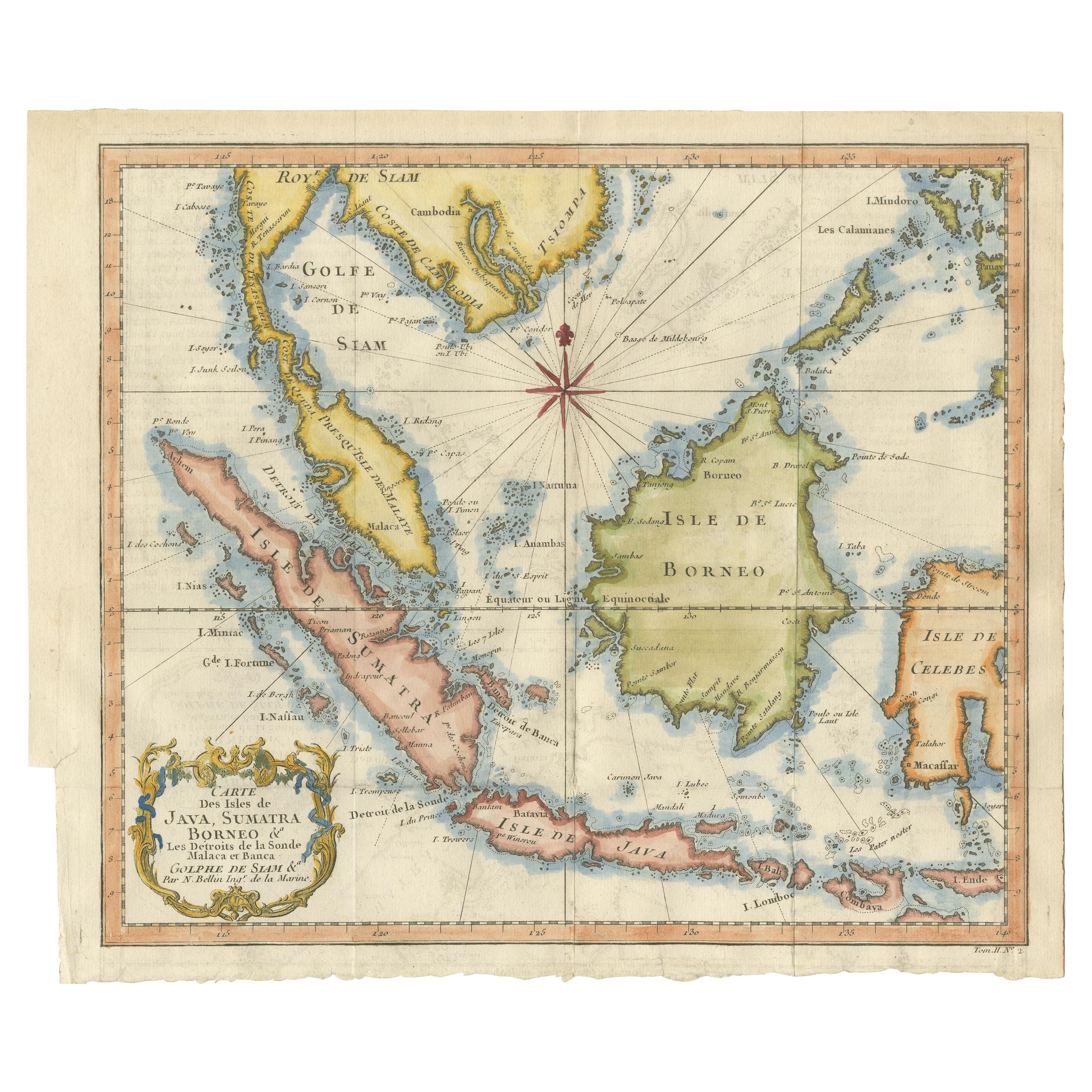
- Antique Engraving of Malaysia, Brunei, Singapore, Java, Borneo, Sumatra, c.1750Located in Langweer, NLNice decorative and detailed map from the Gulf of Siam and Mindoro to Timo, Java and Sumatra Borneo and Roy de Siam. Large compass rose and nice cartouche. Title: Carte des Isles ...Category
Antique Mid-18th Century Maps
MaterialsPaper
- Antique Map of the Sunda Islands Sumatra, Java, Malay Peninsula & Borneo (1739)By Isaak TirionLocated in Langweer, NLAntique map titled 'Nieuwe kaart van de Sundasche Eilanden als Borneo, Sumatra en Groot Iava & c'. Detailed map of the Sunda Islands, Southeast Asia, extending from the tip of Cambod...Category
Antique Mid-18th Century Maps
MaterialsPaper
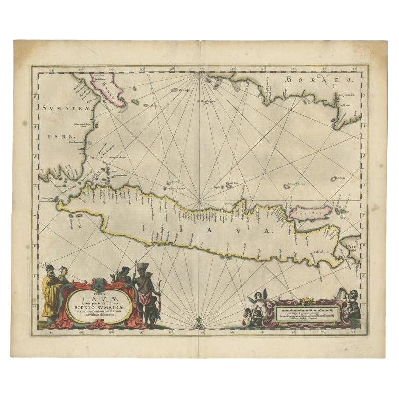
- Antique Map of Java and Part of Borneo, Indonesia, c.1657Located in Langweer, NLAntique map titled 'Insulae Iavae cum parte insularum Boreno Sumatrae (..)'. Beautiful map of the island of Java and part of Borneo, Bali, Madura and Sumatra. With decorative carto...Category
Antique 17th Century Maps
MaterialsPaper
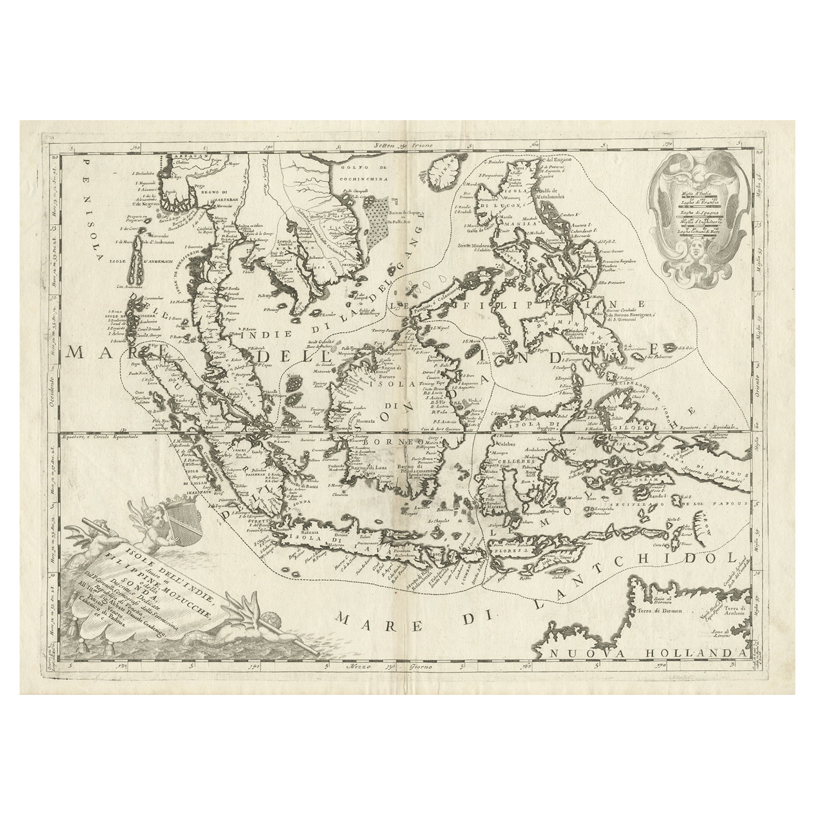
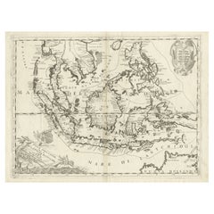
- Original Antique Map of the Philippines, Malaysia, Indonesia, Singapore, c.1690Located in Langweer, NLAntique map titled 'Isole dell' Indie, diuise in Filippine, Molucche e della Sonda'. Old map of the Philippines, Malaysia, Indonesia, Singapore, Northern Australia and contiguous i...Category
Antique 1690s Maps
MaterialsPaper
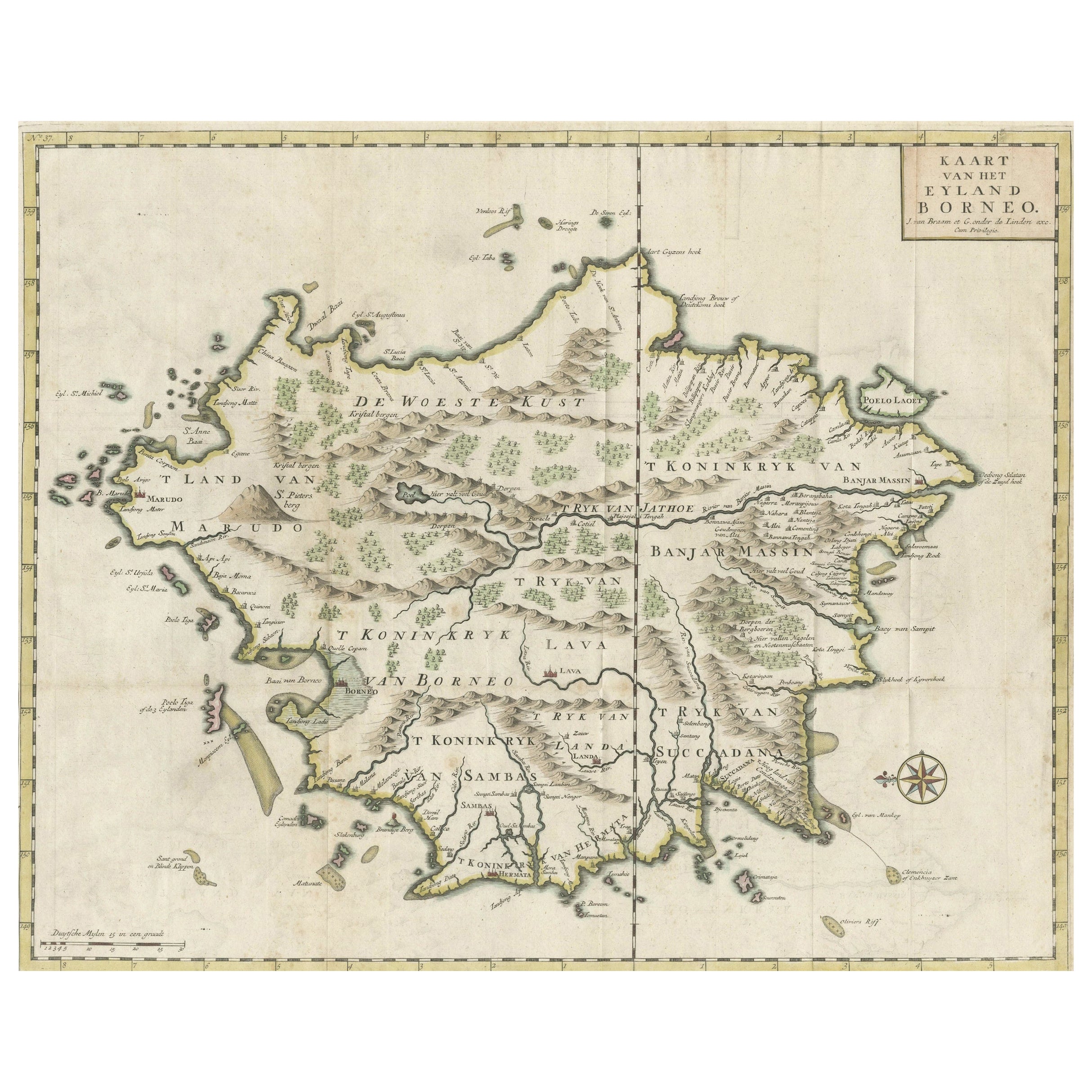
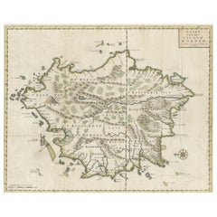
- Old Antique Map of Borneo 'Kalimantan Indonesia, Sabah Malaysia & Brunei'Located in Langweer, NLAntique map titled 'Kaart van het Eyland Borneo'. Original antique map of the island of Borneo. Published 1724-1726 by Joannes van Braam and Gerard Onder de ...Category
Antique Early 18th Century Maps
MaterialsPaper
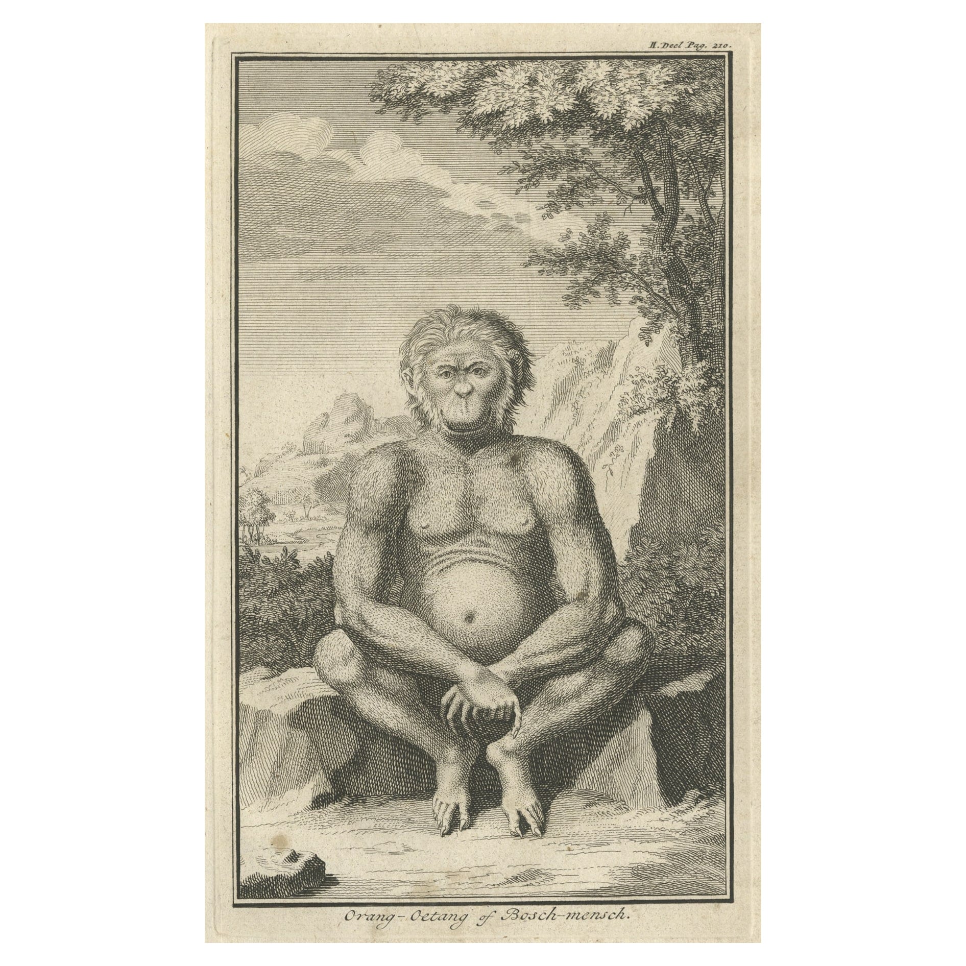
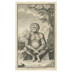
- Engraving of an Orang-Utan on Borneo 'Kalimantan' or Sumatra, Indonesia, 1739Located in Langweer, NLAntique print titled 'Orang-Oetang of Bosch-mensch'. This print depicts an Orang-Utan on Borneo or Sumatra, Indonesia. Originates from 'Hedendaagsche Historie, of tegenwoordige staat...Category
Antique 1730s Prints
MaterialsPaper


You May Also Like
- Large Original Antique Map of Java and Borneo, Fullarton, C.1870Located in St Annes, LancashireGreat map of Java and Borneo Wonderful figurative borders From the celebrated Royal Illustrated Atlas Lithograph. Original color. Published by Fullarton, Edinburgh. C.1870 Unfr...Category
Antique 1870s Scottish Maps
MaterialsPaper
- Antique Map of Principality of MonacoBy Antonio Vallardi EditoreLocated in Alessandria, PiemonteST/619 - "Old Geographical Atlas of Italy - Topographic map of ex-Principality of Monaco" - ediz Vallardi - Milano - A somewhat special edition ---Category
Antique Late 19th Century Italian Other Prints
MaterialsPaper
- Original Antique Map of Spain and Portugal, circa 1790Located in St Annes, LancashireSuper map of Spain and Portugal Copper plate engraving by A. Bell Published, circa 1790. Unframed.Category
Antique 1790s English Other Maps
MaterialsPaper
- Original Antique Map of Ireland- Tipperary and Waterford. C.1840Located in St Annes, LancashireGreat map of Tipperary and Waterford Steel engraving Drawn under the direction of A.Adlard Published by How and Parsons, C.1840 Unframed.Category
Antique 1840s English Maps
MaterialsPaper
- Original Antique Map of Sweden and Norway, Grattan and Gilbert, 1843Located in St Annes, LancashireGreat map of Sweden and Norway Drawn and engraved by Archer Published by Grattan and Gilbert Original color Unframed.Category
Antique 1840s English Other Maps
MaterialsPaper
- Original Antique Map of United States, Grattan and Gilbert, 1843Located in St Annes, LancashireGreat map of United States Drawn and engraved by Archer Published by Grattan and Gilbert. 1843 Original colour Unframed.Category
Antique 1840s English Maps
MaterialsPaper


Recently Viewed
View AllMore Ways To Browse
Antique Decor And More
Antique And Modern Decor
Singapore Furniture
Furniture From Singapore
Java Antique Furniture
Dutch Indonesia
Indonesian Dutch
Java Wood
Monumental Victorian
18th Century Indonesian
18th Century Indonesia
Java Antiques
Tire Antique
Antique Tires
Cambodian Antique
Indonesian House
Antique Wood From Indonesia
Java Dutch