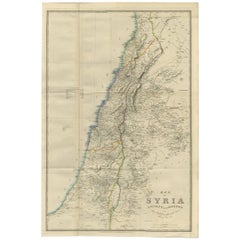
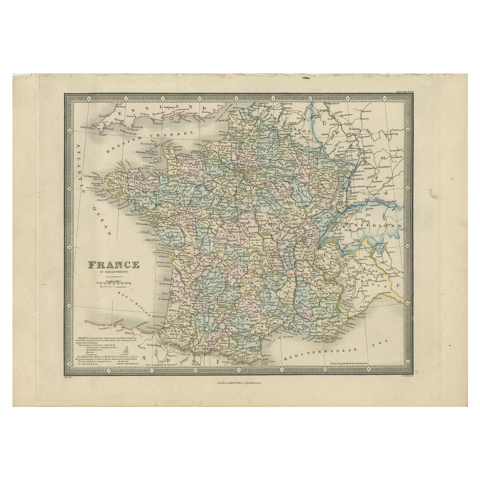
Antique Map of Syria by J. Wyld, 1840
View Similar Items


Want more images or videos?
Request additional images or videos from the seller
1 of 4
Antique Map of Syria by J. Wyld, 1840
About the Item
- Creator:J. Wyld (Artist)
- Dimensions:Height: 39.38 in (100 cm)Width: 26.38 in (67 cm)Depth: 0.02 in (0.5 mm)
- Period:
- Date of Manufacture:1840
- Condition:Please study images carefully.
- Seller Location:Langweer, NL
- Reference Number:Seller: D-00811stDibs: LU305438972481
About the Seller
5.0
Recognized Seller
These prestigious sellers are industry leaders and represent the highest echelon for item quality and design.
Gold Seller
Premium sellers maintaining a 4.3+ rating and 24-hour response times
Established in 2009
1stDibs seller since 2017
2,452 sales on 1stDibs
Authenticity Guarantee
In the unlikely event there’s an issue with an item’s authenticity, contact us within 1 year for a full refund. DetailsMoney-Back Guarantee
If your item is not as described, is damaged in transit, or does not arrive, contact us within 7 days for a full refund. Details24-Hour Cancellation
You have a 24-hour grace period in which to reconsider your purchase, with no questions asked.Vetted Professional Sellers
Our world-class sellers must adhere to strict standards for service and quality, maintaining the integrity of our listings.Price-Match Guarantee
If you find that a seller listed the same item for a lower price elsewhere, we’ll match it.Trusted Global Delivery
Our best-in-class carrier network provides specialized shipping options worldwide, including custom delivery.More From This Seller
View AllAntique Map of Syria by Wyld '1845'
Located in Langweer, NL
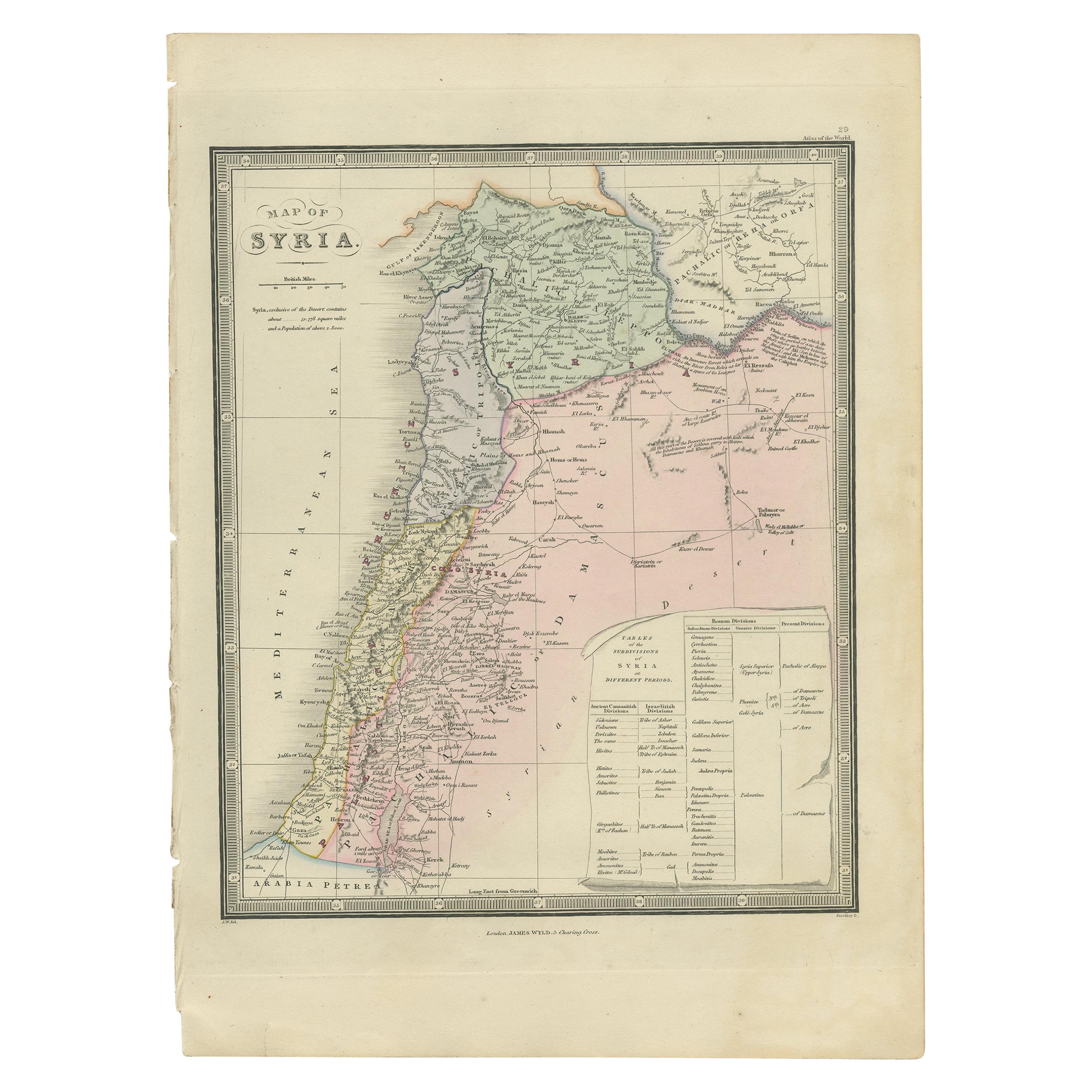
Antique map titled 'Map of Syria'. Original antique map of Syria. This map originates from 'An Atlas of the World, Comprehending Separate Maps of its
Var...
Category
Antique Mid-19th Century Maps
Materials
Paper

$231 Sale Price
20% Off
Antique Map of South America by Wyld, circa 1850
By J. Wyld
Located in Langweer, NL
Beautiful folding map of South America titled 'Colombia Prima or South America Drawn from the Large Map in Eight Sheets by Louis Stanislas D ' Arcy Delarochette'. Three insets in the...
Category
Antique Mid-19th Century British Maps
Materials
Paper

$1,345 Sale Price
20% Off
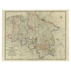
Antique Map of Northern Germany by Wyld, c.1840
Located in Langweer, NL
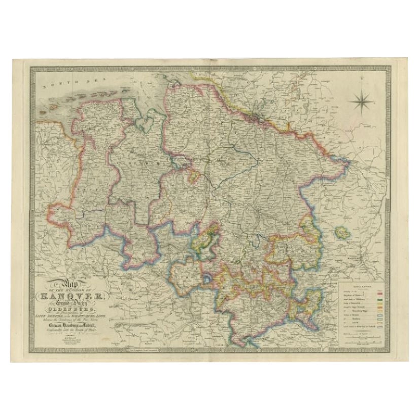
Antique map titled 'Map of the Kingdom of Hanover, with the Grand Duchy of Oldenburg, the Principalities of Lippe Detmold and Schauenburg Lippe, likewise the Territories of the Free ...
Category
Antique 19th Century Maps
Materials
Paper
$366 Sale Price
20% Off
Antique Map of Brazil by Wyld, '1845'
Located in Langweer, NL
Antique map titled 'Empire of Brazil'. Original antique map of Brazil. This map originates from 'An Atlas of the World, Comprehending Separate Ma...
Category
Antique Mid-19th Century Maps
Materials
Paper

$231 Sale Price
20% Off
Antique Map of Asia by Wyld '1845'
Located in Langweer, NL
Antique map titled 'Asia'. Original antique map of Asia. This map originates from 'An Atlas of the World, Comprehending Separate Maps of its Variou...
Category
Antique Mid-19th Century Maps
Materials
Paper

$185 Sale Price
20% Off
Antique Map of Europe by Wyld '1845'
Located in Langweer, NL
Antique map titled 'Europe'. Original antique map of Europe. This map originates from 'An Atlas of the World, Comprehending Separate Maps of its ...
Category
Antique Mid-19th Century Maps
Materials
Paper

$139 Sale Price
20% Off
You May Also Like
Original Antique Map of Ireland- Kerry. C.1840
Located in St Annes, Lancashire
Great map of Kerry
Steel engraving
Drawn under the direction of A.Adlard
Published by How and Parsons, C.1840
Unframed.
Category
Antique 1840s English Maps
Materials
Paper

Original Antique Map of Ireland- Tipperary and Waterford. C.1840
Located in St Annes, Lancashire
Great map of Tipperary and Waterford
Steel engraving
Drawn under the direction of A.Adlard
Published by How and Parsons, C.1840
Unframed.
Category
Antique 1840s English Maps
Materials
Paper

1840 Map of the City of Washington Published by William M. Morrison
Located in Colorado Springs, CO
This map, printed in 1840, is a detailed representation of Washington, D.C. in the mid-19th century. The map shows block numbers, wards, and government buildings as well as details o...
Category
Antique 1840s American Federal Maps
Materials
Paper

Antique Map of Italy by Andriveau-Goujon, 1843
By Andriveau-Goujon
Located in New York, NY
Antique Map of Italy by Andriveau-Goujon, 1843. Map of Italy in two parts by Andriveau-Goujon for the Library of Prince Carini at Palazzo Carini i...
Category
Antique 1840s French Maps
Materials
Linen, Paper

$3,350 / set
Antique Map of Principality of Monaco
By Antonio Vallardi Editore
Located in Alessandria, Piemonte
ST/619 - "Old Geographical Atlas of Italy - Topographic map of ex-Principality of Monaco" -
ediz Vallardi - Milano -
A somewhat special edition ---
Category
Antique Late 19th Century Italian Other Prints
Materials
Paper

1840 "New Map of the City of New York With Part of Brooklyn & Williamsburg"
Located in Colorado Springs, CO
Presented is a hand-colored, engraved folding map titled "New Map of the City of New York With Part of Brooklyn & Williamsburg" by J. Calvin Smith. The map was issued bound in the bo...
Category
Antique 1840s American Maps
Materials
Paper

Recently Viewed
View AllMore Ways To Browse
Antique Lebanese Furniture
Lebanese Antiques
1960s Metal Benches
1960s Swivel Chairs Pair
54 Round Dining Table
7 Chair Fritz
70s Console Table
Aluminum Group Desk Chairs By Charles Eames
Antique American Silver Pitchers
Antique Ottoman Silk
Antique Wooden Armchair 20th Century
Art Deco Sterling Silver Silverware
Baker Cocktail Coffee Table
Bent Stainless Steel
Bird Sofa
Black And Gold Lacquer Console
Black And White Tableware
Black Minimal Bench