Items Similar to Antique Map of Northern Germany by Wyld, c.1840


Want more images or videos?
Request additional images or videos from the seller
1 of 5
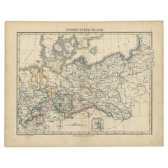
Antique Map of Northern Germany by Wyld, c.1840
About the Item
Antique map titled 'Map of the Kingdom of Hanover, with the Grand Duchy of Oldenburg, the Principalities of Lippe Detmold and Schauenburg Lippe, likewise the Territories of the Free Towns of Bremen, Hamburg and Lubeck Conformably with the Treaty of Paris'. Scarce regional map of Northern Germany filled with superb detail. Source unknown, to be determined. Artists and Engravers: James Wyld (1812?1887) was a British geographer and map-seller, best known for Wyld's Great Globe. He was successor to William Faden, one of the luminaries of late eighteenth century publishing in England. Wyld maintained the high standard of graphic and factual excellence that had been established by his predecessor and his maps are among the finest published in the early nineteenth century.
Artist: James Wyld (1812-1887) was a British geographer and map-seller, best known for Wyld's Great Globe. He was successor to William Faden, one of the luminaries of late eighteenth century publishing in England. Wyld maintained the high standard of graphic and factual excellence that had been established by his predecessor and his maps are among the finest published in the early nineteenth century.
Condition: Good, given age. A few minor unobtrusive spots. Original middle fold as issued. General age-related toning and/or occasional minor defects from handling. Please study image carefully.
Date: c.1840
Overall size: 75.3 x 58.3 cm.
Image size: 0.001 x 68 x 55.5 cm.
Antique prints have long been appreciated for both their aesthetic and investment value. They were the product of engraved, etched or lithographed plates. These plates were handmade out of wood or metal, which required an incredible level of skill, patience and craftsmanship. Whether you have a house with Victorian furniture or more contemporary decor an old engraving can enhance your living space. We offer a wide range of authentic antique prints for any budget.
- Dimensions:Height: 22.96 in (58.3 cm)Width: 29.65 in (75.3 cm)Depth: 0 in (0.01 mm)
- Materials and Techniques:
- Period:
- Date of Manufacture:circa 1840
- Condition:
- Seller Location:Langweer, NL
- Reference Number:
About the Seller
5.0
Platinum Seller
These expertly vetted sellers are 1stDibs' most experienced sellers and are rated highest by our customers.
Established in 2009
1stDibs seller since 2017
1,929 sales on 1stDibs
Typical response time: <1 hour
- ShippingRetrieving quote...Ships From: Langweer, Netherlands
- Return PolicyA return for this item may be initiated within 14 days of delivery.
More From This SellerView All
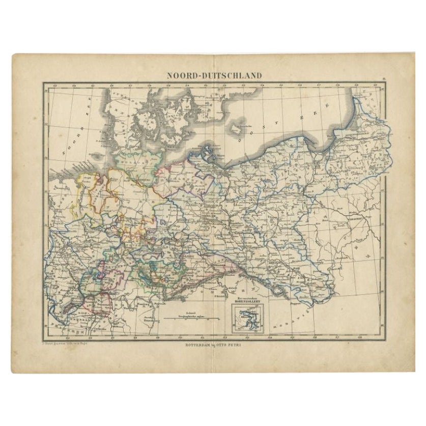
- Antique Map of Northern Germany by Petri, c.1873Located in Langweer, NLAntique map titled 'Noord-Duitschland'. Old map depicting northern Germany. This map originates from 'School-Atlas van alle Deelen der Aarde'. Artists and Engravers: Published by O. ...Category
Antique 19th Century Maps
MaterialsPaper
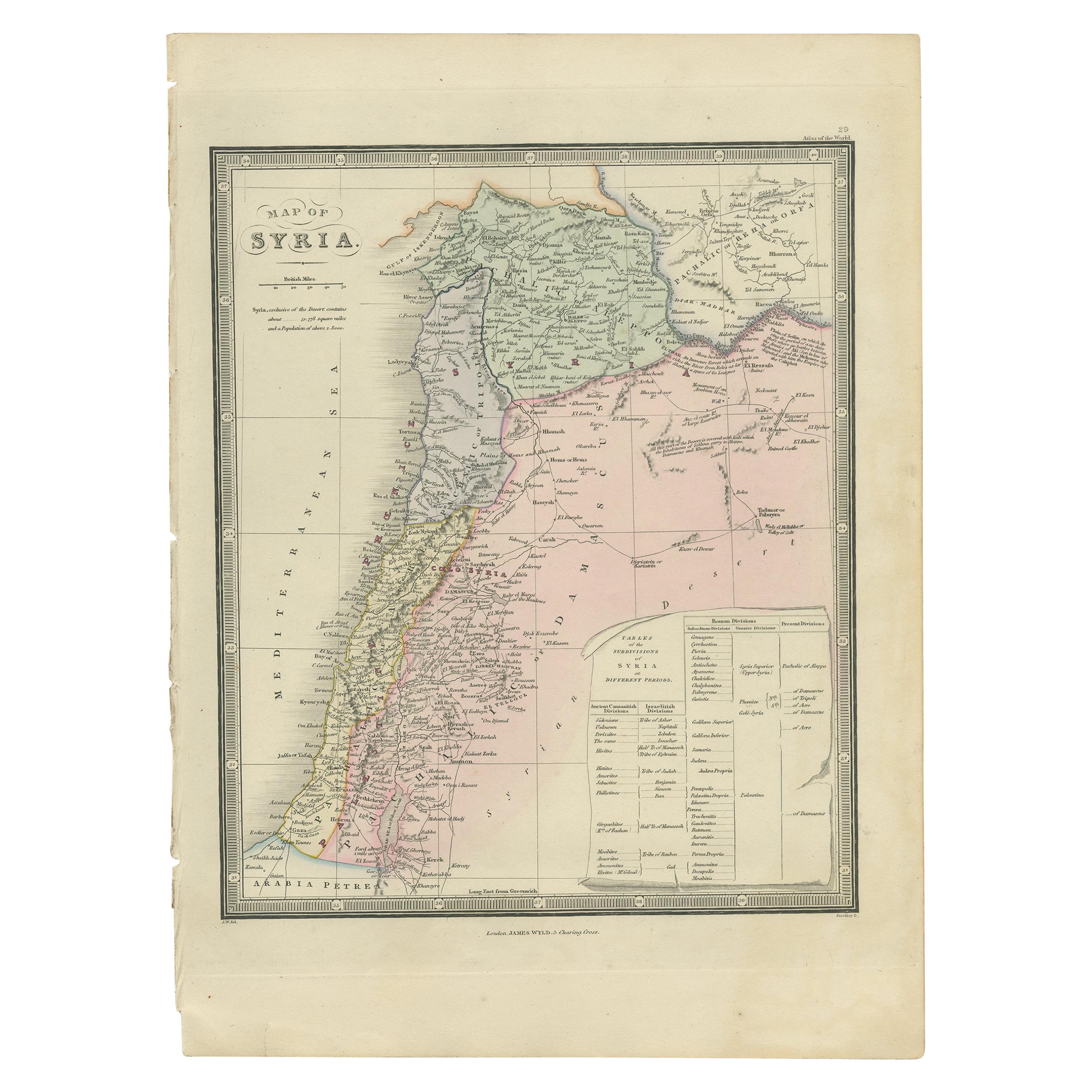
- Antique Map of Syria by Wyld '1845'Located in Langweer, NLAntique map titled 'Map of Syria'. Original antique map of Syria. This map originates from 'An Atlas of the World, Comprehending Separate Maps of its Var...Category
Antique Mid-19th Century Maps
MaterialsPaper
- Antique Map of Brazil by Wyld, '1845'Located in Langweer, NLAntique map titled 'Empire of Brazil'. Original antique map of Brazil. This map originates from 'An Atlas of the World, Comprehending Separate Ma...Category
Antique Mid-19th Century Maps
MaterialsPaper
- Antique Map of Europe by Wyld '1845'Located in Langweer, NLAntique map titled 'Europe'. Original antique map of Europe. This map originates from 'An Atlas of the World, Comprehending Separate Maps of its ...Category
Antique Mid-19th Century Maps
MaterialsPaper
- Antique Map of Asia by Wyld '1845'Located in Langweer, NLAntique map titled 'Asia'. Original antique map of Asia. This map originates from 'An Atlas of the World, Comprehending Separate Maps of its Variou...Category
Antique Mid-19th Century Maps
MaterialsPaper
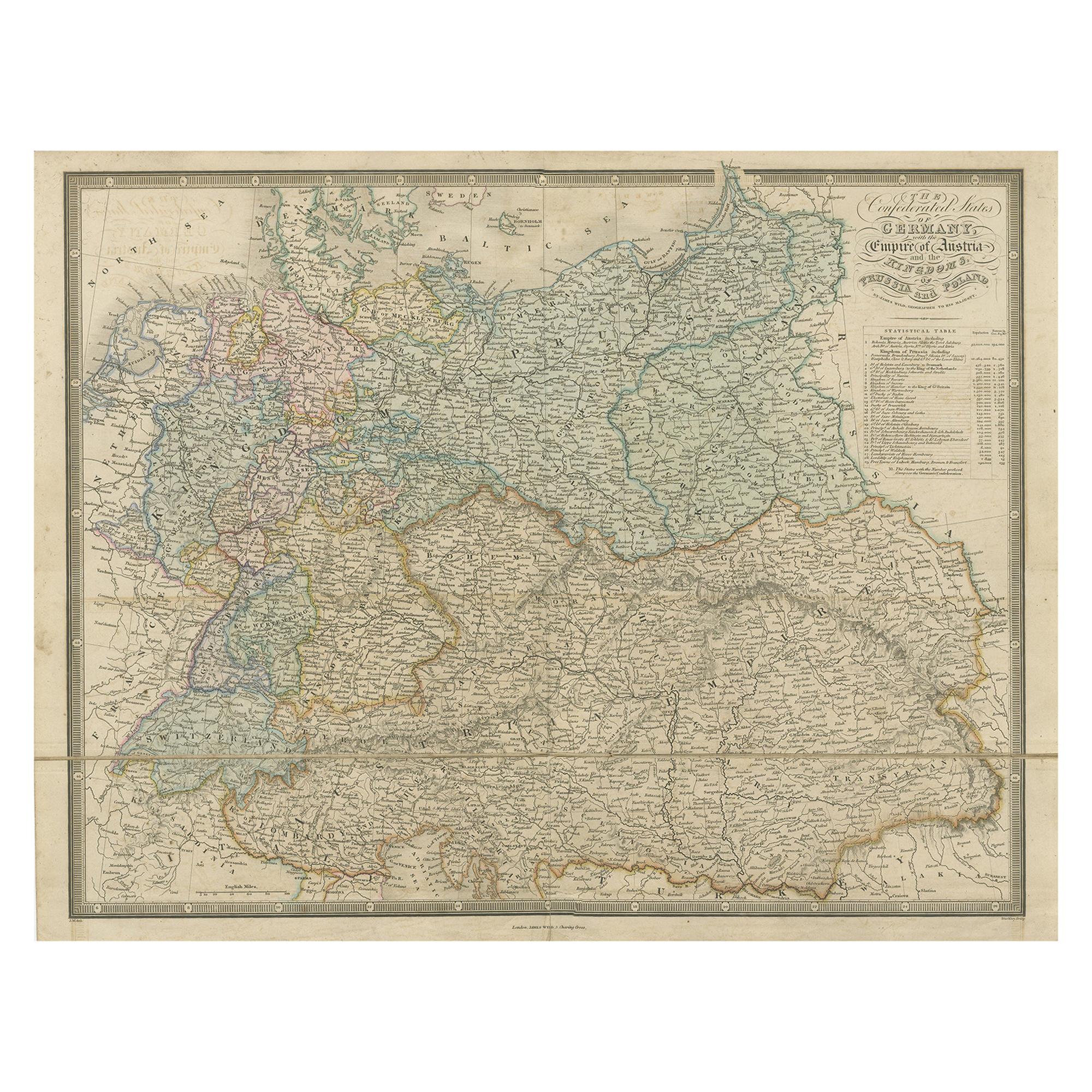
- Antique Map of Germany with the Empire of Austria by Wyld '1845'Located in Langweer, NLAntique map titled 'The Confederated States of Germany with the Empire of Austria, and The Kingdoms of Prussia and Poland'. Original antique map of ...Category
Antique Mid-19th Century Maps
MaterialsPaper


You May Also Like
- Original Antique Map of Ireland- Kerry. C.1840Located in St Annes, LancashireGreat map of Kerry Steel engraving Drawn under the direction of A.Adlard Published by How and Parsons, C.1840 Unframed.Category
Antique 1840s English Maps
MaterialsPaper
- Original Antique Map of South East Asia by Becker, circa 1840Located in St Annes, LancashireGreat map of South East Asia Steel engraving with original color outline Engraved by Becker Published by Virtue, circa 1840. Unframed.Category
Antique 1840s English Other Maps
MaterialsPaper
- Original Antique Map of Ireland- Tipperary and Waterford. C.1840Located in St Annes, LancashireGreat map of Tipperary and Waterford Steel engraving Drawn under the direction of A.Adlard Published by How and Parsons, C.1840 Unframed.Category
Antique 1840s English Maps
MaterialsPaper
- 1840 Map of the City of Washington Published by William M. MorrisonLocated in Colorado Springs, COThis map, printed in 1840, is a detailed representation of Washington, D.C. in the mid-19th century. The map shows block numbers, wards, and government buildings as well as details o...Category
Antique 1840s American Federal Maps
MaterialsPaper
- East German MapBy VEB Hermann HaackLocated in Baltimore, MDA brilliantly colourful map of the Leipzig, Karl Marx Stadt and Dresden area in the former German Democratic Republic by VEB Hermann Haack of Gotha.Category
Vintage 1970s German Maps
- Set of 4 Antique Geographical Maps French-German War 1870-71Located in Casale Monferrato, ITElegant late 19th century set of four antique geographical maps relating to the positioning of the armies in the Franco-German War 1870-71. A...Category
Antique 1890s Italian Maps
MaterialsPaper


Recently Viewed
View AllMore Ways To Browse
1840 C
Great Northern
19th Century German Collectibles
German Furniture Hamburg
James Free
Antique Plate With Metal Handle
Antique German Decor
Antique Metal Globes
Great Britain Maps
Old Map Of Paris
Antique Britain Map
Antique Map Britain
Hanover Furniture
Antique Paris Map Print
Antique Map Globe
Hanover Used Furniture
Map Of Great Britain
Globe Engraving