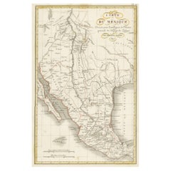
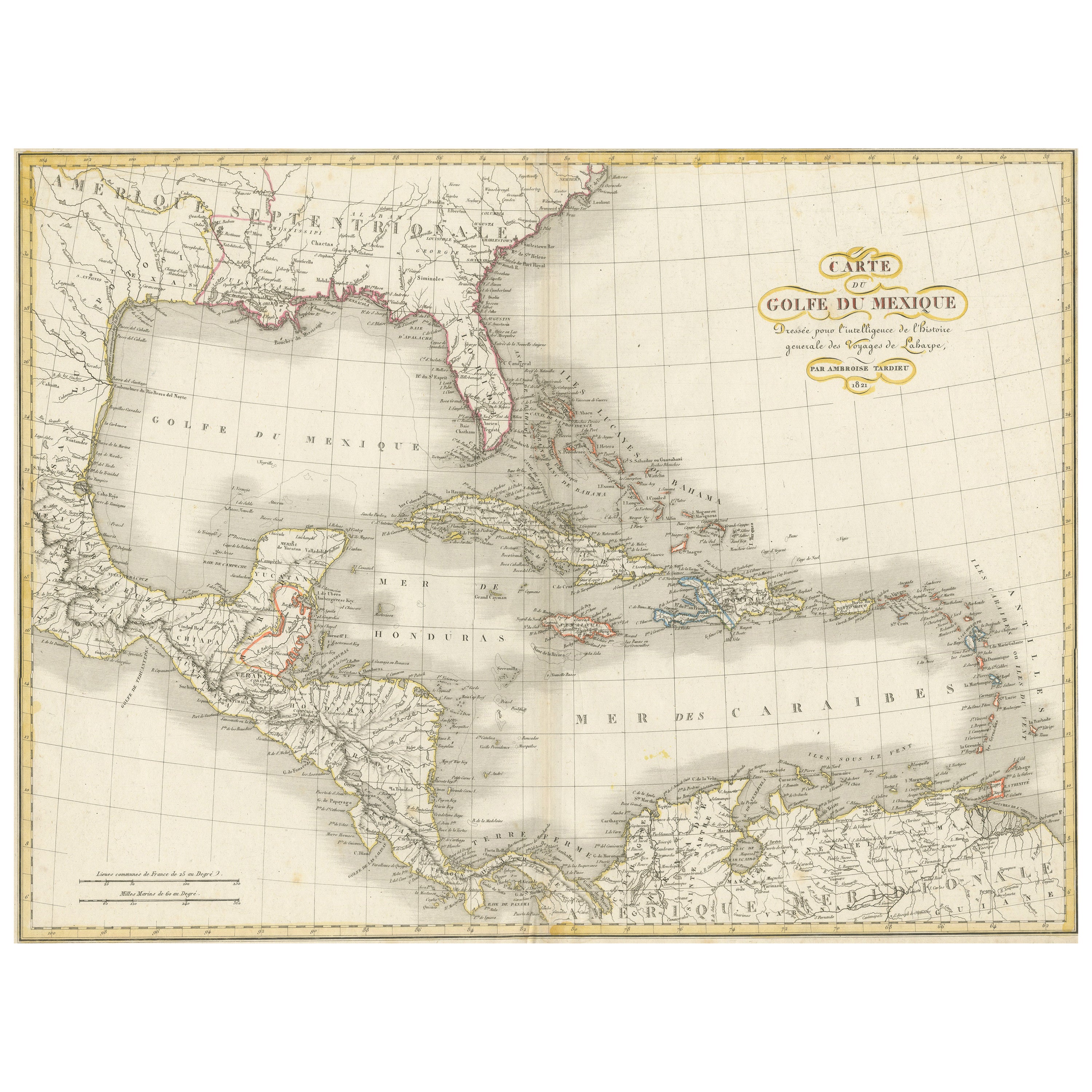
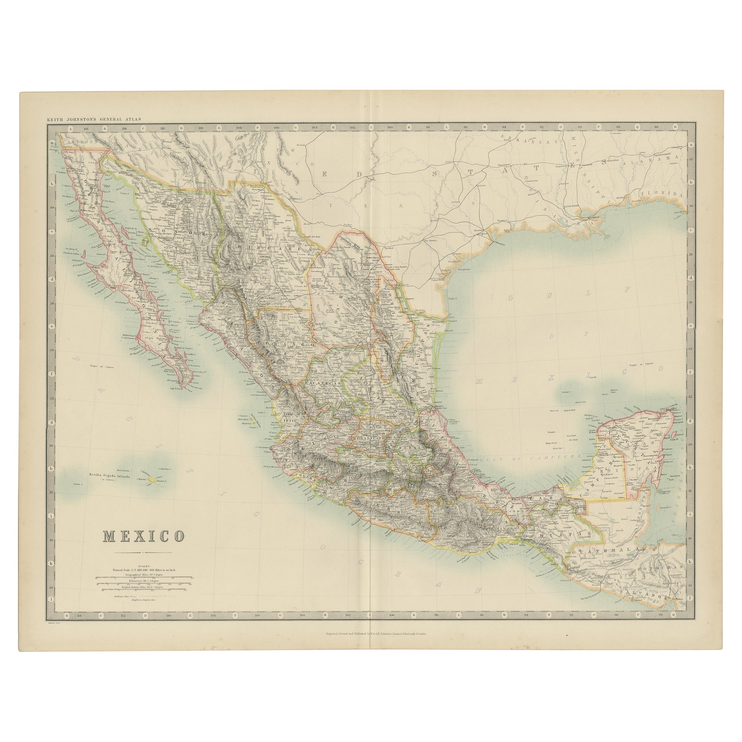
Antique Map of Texas, the Rocky Mountains, Southwest and Mexico
View Similar Items


Want more images or videos?
Request additional images or videos from the seller
1 of 6
Antique Map of Texas, the Rocky Mountains, Southwest and Mexico
About the Item
- Dimensions:Height: 17.41 in (44.2 cm)Width: 11.62 in (29.5 cm)Depth: 0.02 in (0.5 mm)
- Materials and Techniques:
- Period:
- Date of Manufacture:1821
- Condition:Wear consistent with age and use. General age-related toning. Minor wear and foxing, blank verso. Few small tears in margins. Please study image carefully.
- Seller Location:Langweer, NL
- Reference Number:Seller: BG-13190-61stDibs: LU3054331144352
About the Seller
5.0
Recognized Seller
These prestigious sellers are industry leaders and represent the highest echelon for item quality and design.
Gold Seller
Premium sellers maintaining a 4.3+ rating and 24-hour response times
Established in 2009
1stDibs seller since 2017
2,452 sales on 1stDibs
Authenticity Guarantee
In the unlikely event there’s an issue with an item’s authenticity, contact us within 1 year for a full refund. DetailsMoney-Back Guarantee
If your item is not as described, is damaged in transit, or does not arrive, contact us within 7 days for a full refund. Details24-Hour Cancellation
You have a 24-hour grace period in which to reconsider your purchase, with no questions asked.Vetted Professional Sellers
Our world-class sellers must adhere to strict standards for service and quality, maintaining the integrity of our listings.Price-Match Guarantee
If you find that a seller listed the same item for a lower price elsewhere, we’ll match it.Trusted Global Delivery
Our best-in-class carrier network provides specialized shipping options worldwide, including custom delivery.More From This Seller
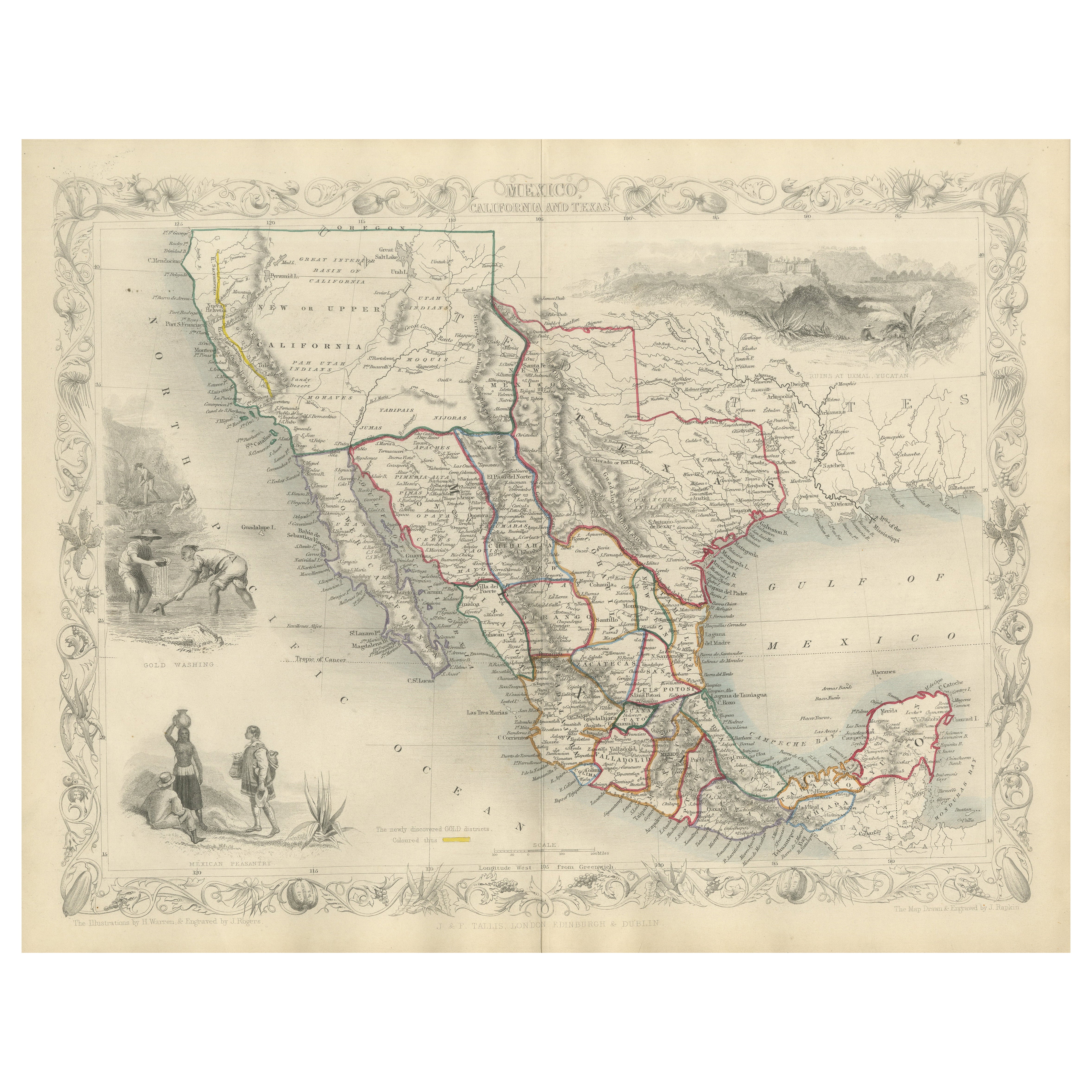
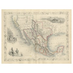
View AllTexas California Mexico Map – Antique Tallis Map with Gold Region, c.1850
Located in Langweer, NL
Texas California Mexico Map – Antique Tallis Map with Gold Region, c.1850
This highly decorative and historically rich map titled 'Mexico, California and Texas' was published around...
Category
Antique Mid-19th Century Maps
Materials
Paper
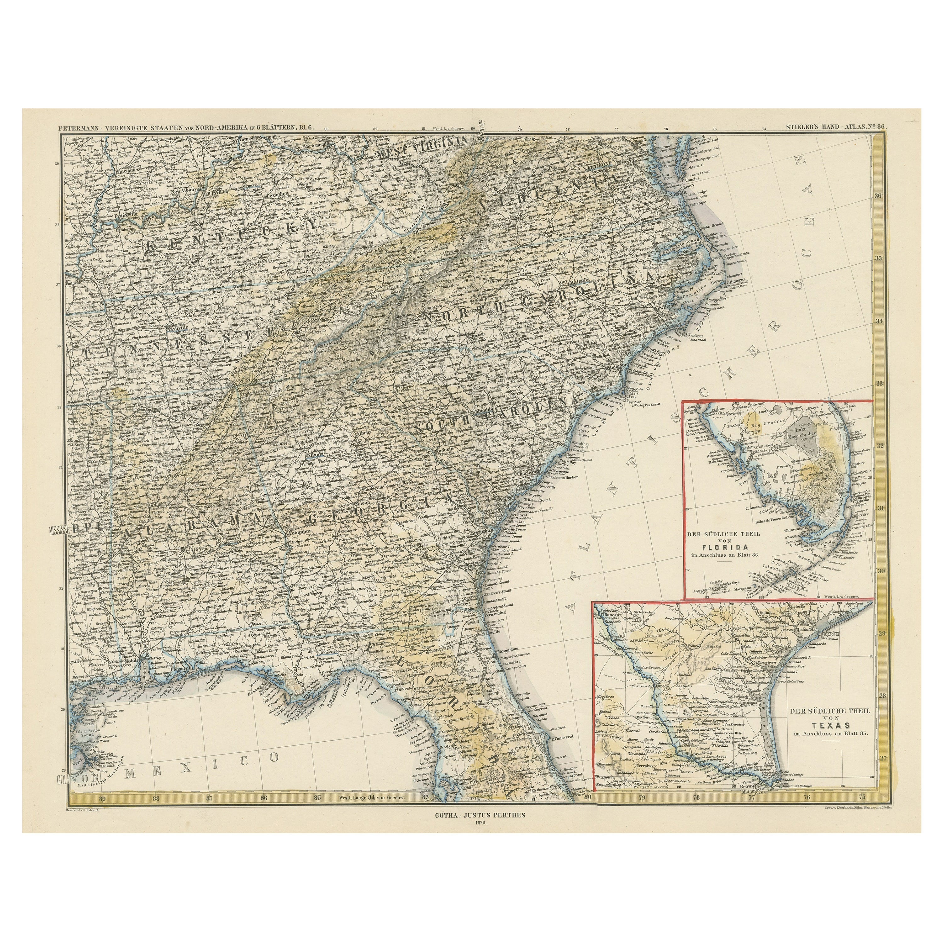
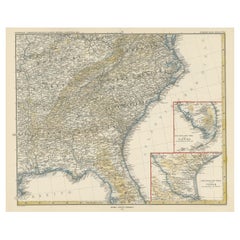
Antique Map of the Region of Georgia with Inset Maps of Florida and Texas
Located in Langweer, NL
Antique map of part of the United States showing Alabama, Georgia, North Carolina, South Carolina, Tennessee, Kentucky, Virginia and part of Florida. With inset maps of the southern ...
Category
Antique Late 19th Century Maps
Materials
Paper
$510 Sale Price
50% Off
Antique Map of the Eastern United States with Inset Map of Texas
Located in Langweer, NL
Antique map titled 'Verein-Staaten von Nord-America mit Ausnahme Florida's und der Westlichen Territorien'. This map extends as far west as Louisiana and only includes the northern p...
Category
Antique Mid-19th Century Maps
Materials
Paper

$500 Sale Price
20% Off
Antique Map of the United States with inset map of the region of Mexico City
Located in Langweer, NL
Antique map titled 'Verein-Staaten von Nord-America, Mexico, Yucatan u.a.'. Very detailed map of the United States of America showing the Caribbean. With an inset map of the surround...
Category
Antique Mid-19th Century Maps
Materials
Paper

$797 Sale Price
20% Off
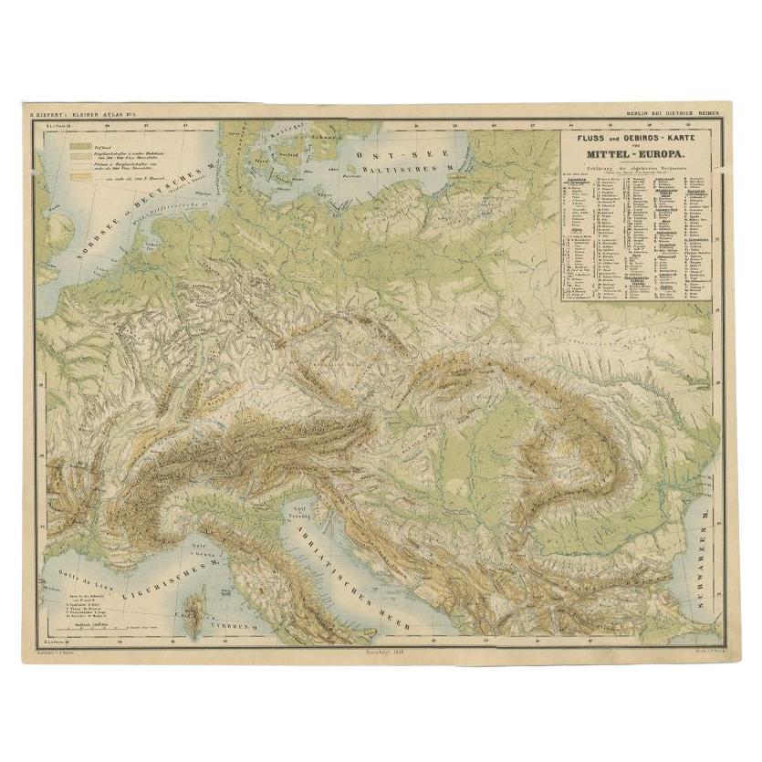
Nice Colourful Antique Map of the Rivers and Mountains of Europe c.1870
By Heinrich Kiepert
Located in Langweer, NL
Antique map titled 'Fluss und Gebirgs Karte von Mittel-Europa'. Old map of the European continent depicting the European mountains and rivers. This map originates from 'H. Kiepert's ...
Category
Antique 19th Century Maps
Materials
Paper
$222 Sale Price
20% Off
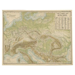
Antique Detailed Map of the Mountain Chains of Europe and Asia, c.1850
Located in Langweer, NL
Antique map titled 'The Mountain Chains of Europe & Asia'.
Old map depicting the mountain chains of Europe and Asia. Originates from 'The Physical Atlas of Natural Phenomena'.
Ar...
Category
Antique 19th Century Maps
Materials
Paper

You May Also Like
Map of the Republic of Genoa
Located in New York, NY
Framed antique hand-coloured map of the Republic of Genoa including the duchies of Mantua, Modena, and Parma.
Europe, late 18th century.
Dimension: 25...
Category
Antique Late 18th Century European Maps

Antique Map of Principality of Monaco
By Antonio Vallardi Editore
Located in Alessandria, Piemonte
ST/619 - "Old Geographical Atlas of Italy - Topographic map of ex-Principality of Monaco" -
ediz Vallardi - Milano -
A somewhat special edition ---
Category
Antique Late 19th Century Italian Other Prints
Materials
Paper

Original Antique Map of The World by Thomas Clerk, 1817
Located in St Annes, Lancashire
Great map of The Eastern and Western Hemispheres
On 2 sheets
Copper-plate engraving
Drawn and engraved by Thomas Clerk, Edinburgh.
Published by Mackenzie And Dent, 1817
...
Category
Antique 1810s English Maps
Materials
Paper

Antique 18th Century Map of the Province of Pensilvania 'Pennsylvania State'
Located in Philadelphia, PA
A fine antique of the colony of Pennsylvania.
Noted at the top of the sheet as a 'Map of the province of Pensilvania'.
This undated and anonymous map is thought to be from the Gentleman's Magazine, London, circa 1775, although the general appearance could date it to the 1760's.
The southern boundary reflects the Mason-Dixon survey (1768), the western boundary is placed just west of Pittsburgh, and the northern boundary is not marked.
The map has a number of reference points that likely refer to companion text and appear to be connected to boundaries. The western and southern boundaries are marked Q, R, S, for example. A diagonal line runs from the Susquehanna R to the Lake Erie P. A broken line marked by many letters A, B, N, O, etc., appears in the east.
There are no latitude or longitude markings, blank verso.
Framed in a shaped contemporary gilt wooden frame and matted under a cream colored matte.
Bearing an old Graham Arader Gallery...
Category
Antique 18th Century British American Colonial Maps
Materials
Paper

Original Antique Map of Spain and Portugal, circa 1790
Located in St Annes, Lancashire
Super map of Spain and Portugal
Copper plate engraving by A. Bell
Published, circa 1790.
Unframed.
Category
Antique 1790s English Other Maps
Materials
Paper

Original Antique Map of Ireland- Tipperary and Waterford. C.1840
Located in St Annes, Lancashire
Great map of Tipperary and Waterford
Steel engraving
Drawn under the direction of A.Adlard
Published by How and Parsons, C.1840
Unframed.
Category
Antique 1840s English Maps
Materials
Paper
