Items Similar to Antique plan of Ayutthaya, the capital of Siam, Thailand

Want more images or videos?
Request additional images or videos from the seller
1 of 6
Antique plan of Ayutthaya, the capital of Siam, Thailand
About the Item
Antique map titled 'Judia, De Hoofd-Stad van Siam'. Antique plan of Ayutthaya, the capital of Siam (Thailand). This print originates from 'Oud en Nieuw Oost-Indiën' by F. Valentijn.
François Valentijn (1666-1727), a missionary, worked at Amboina from 1684 to 1694 and 1705 to 1713 and travelled extensively in the VOC's lands.
- Dimensions:Height: 13.12 in (33.3 cm)Width: 16.82 in (42.7 cm)Depth: 0.02 in (0.5 mm)
- Materials and Techniques:
- Period:
- Date of Manufacture:1726
- Condition:Age-related toning. Shows wear and soiling. Original folding lines with small splits. Image is affected by 5 worm holes. Blank verso. Please study image carefully.
- Seller Location:Langweer, NL
- Reference Number:
About the Seller
5.0
Platinum Seller
These expertly vetted sellers are 1stDibs' most experienced sellers and are rated highest by our customers.
Established in 2009
1stDibs seller since 2017
1,916 sales on 1stDibs
Typical response time: <1 hour
- ShippingRetrieving quote...Ships From: Langweer, Netherlands
- Return PolicyA return for this item may be initiated within 14 days of delivery.
More From This SellerView All
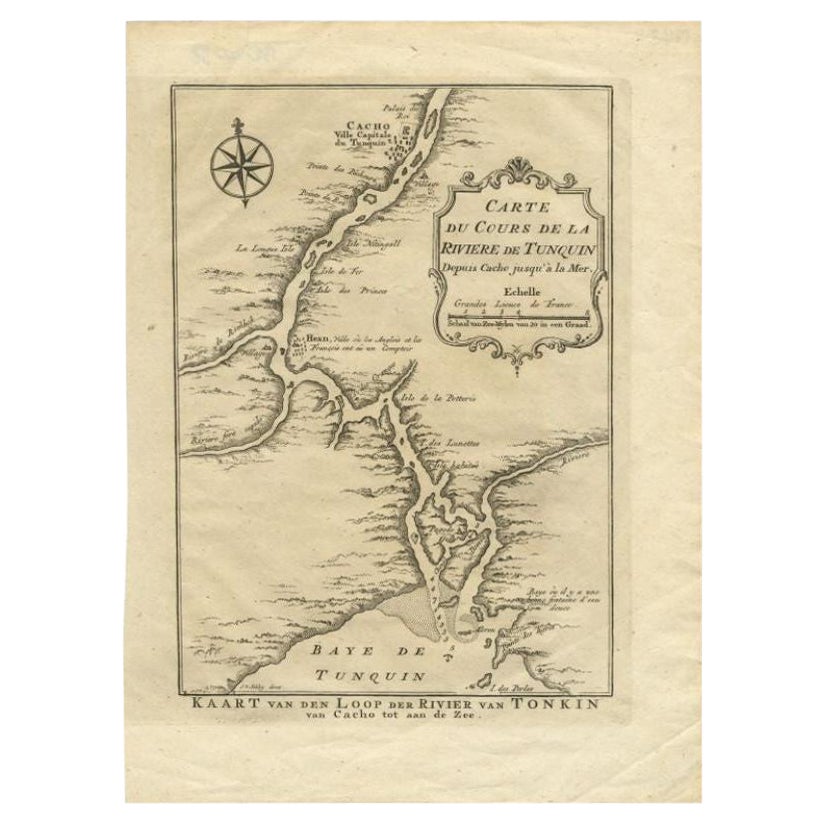
- Antique Map of the Tunquin River and Bay to Cacho, the Capital City, Siam, 1758Located in Langweer, NLAntique map titled ‘Kaart van den Loop der Rivier van Tonkin van Cacho tot aan de Zee / Carte du Cours de la Riviere de Tunquin Depuis Cacho jusqu'à la Mer J. v. Schley direx.’ Detailed map of the Tunquin River and Bay, extending north to Cacho, the capital...Category
Antique 18th Century Maps
MaterialsPaper
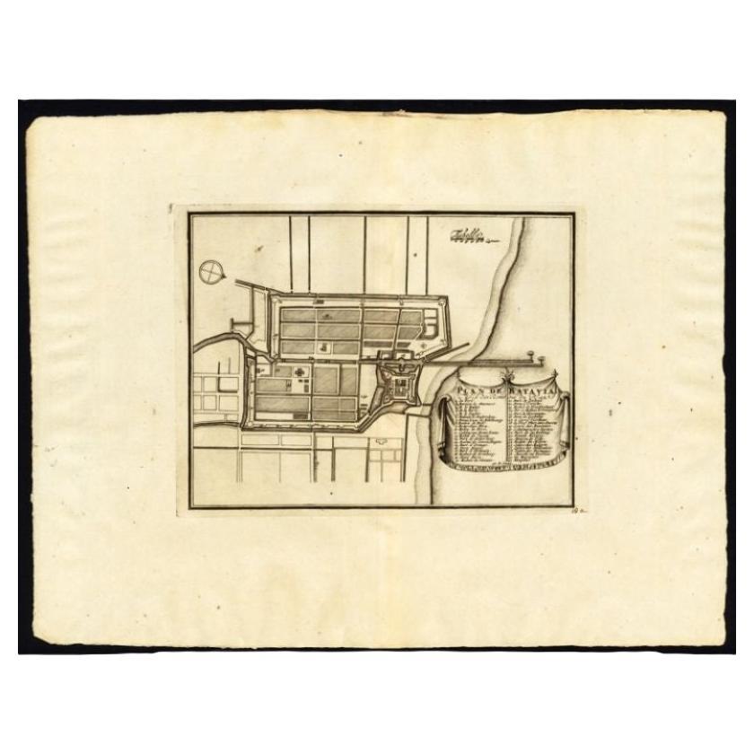
- Antique Plan of Batavia, Capital of the Dutch East Indies, by Van Der Aa, 1725By Pieter Van Der AaLocated in Langweer, NLAntique map titled 'Plan de Batavia'. (Plan of Batavia.) This plate shows a plan of the city of Batavia / Jakarta in Indonesia. With extensive legend, compass rose and scale. This pl...Category
Antique 18th Century Maps
MaterialsPaper
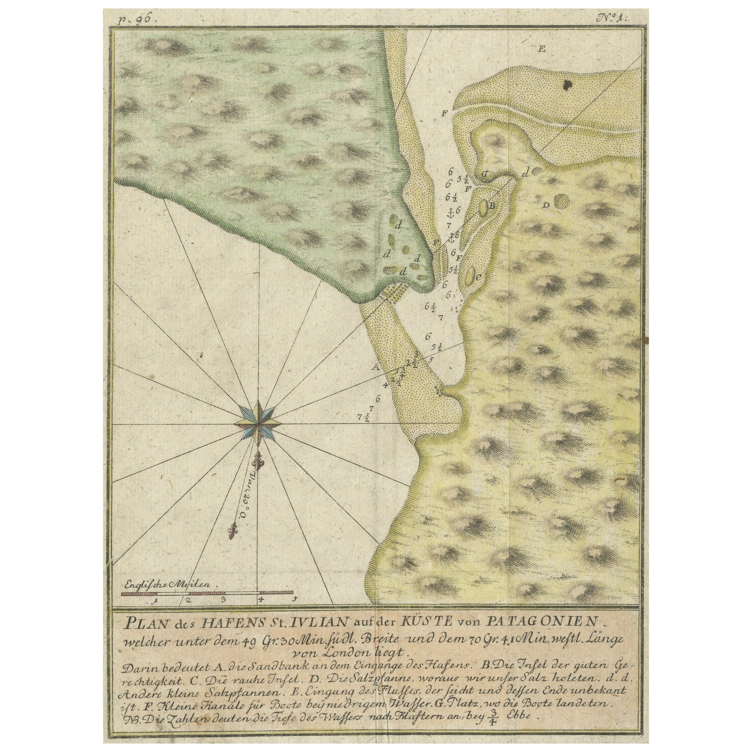
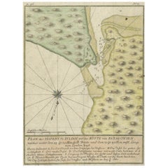
- Antique Plan of Plan of St. Julian's Harbour on the Coast of PatagoniaLocated in Langweer, NLAntique map titled 'Plan des Hafens St. Iulian auf der Küste von Patagonien'. Plan of St. Julian's Harbour on the Coast of Patagonia. This map originates from a German edition of 'Voyage around the World...Category
Antique Mid-18th Century Maps
MaterialsPaper
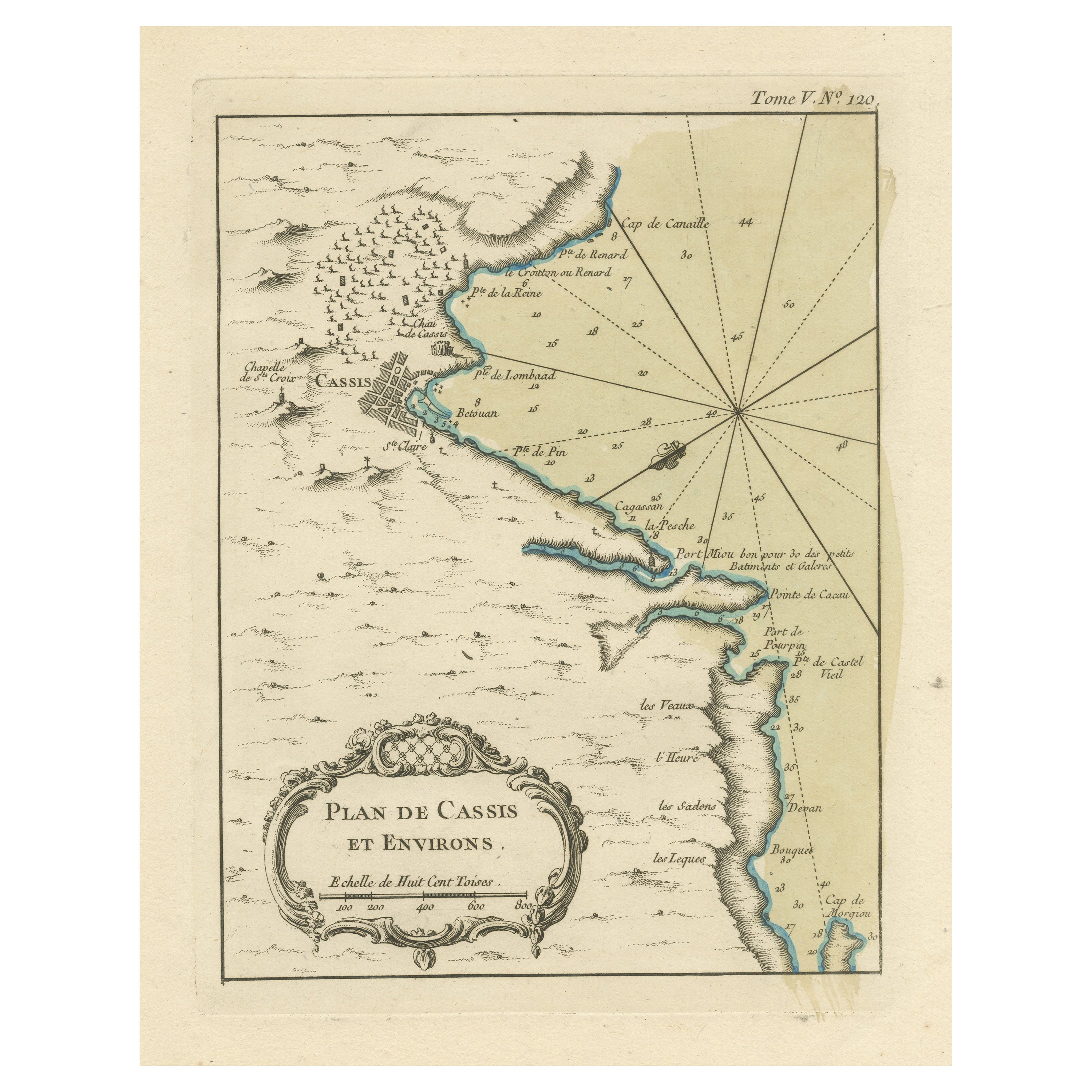
- Antique Plan of the Region of Cassis, FranceLocated in Langweer, NLAntique map titled 'Plan de Cassis et environs'. Original plan of the region of Cassis, France. This map originates from 'Le Petit Atlas Maritime (..)' by J.N. Bellin. Published 1764...Category
Antique Mid-18th Century Maps
MaterialsPaper
- Antique Plan of the City of Bayonne, FranceLocated in Langweer, NLAntique map titled 'Plan de Bayonne'. Original old plan of the city of Bayonne, France. This map originates from 'Le Petit Atlas Maritime (..)' by J.N. Bellin. Published 1764. Be...Category
Antique Mid-18th Century Maps
MaterialsPaper
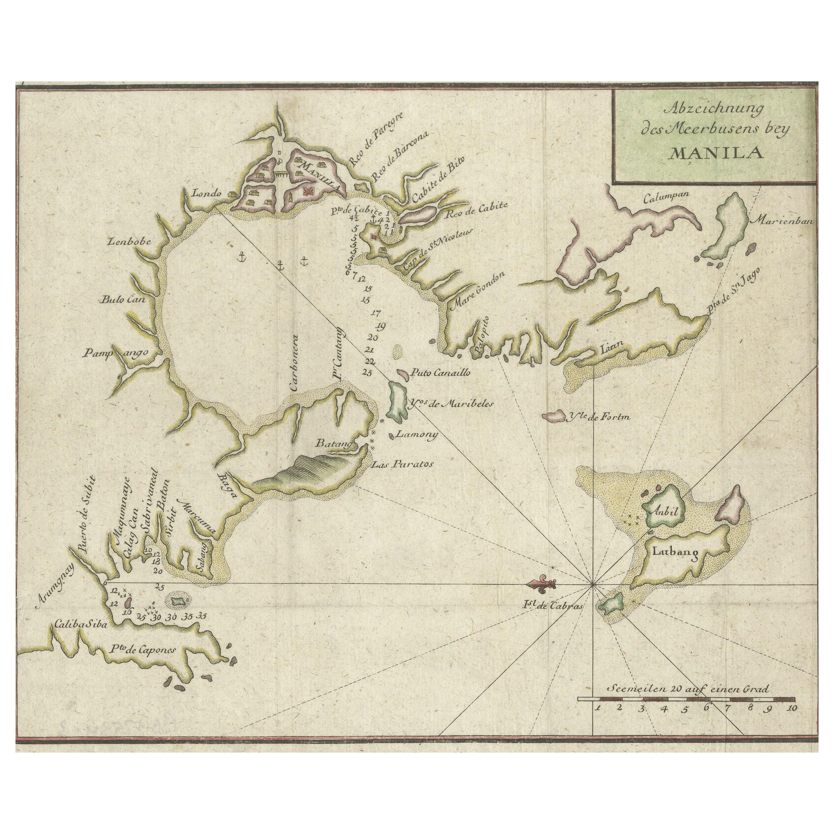
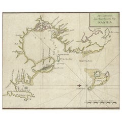
- Antique Map of the Bay of Manila, Capital of the PhilippinesLocated in Langweer, NLAntique map titled 'Abzeichnung des Meerbusens bey Manila'. Map of the Bay of Manila, capital of the Philippines. This map originates from a German edition of 'Voyage around the World...Category
Antique Mid-18th Century Maps
MaterialsPaper


You May Also Like
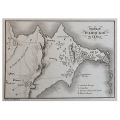
- Original Antique Plan of The Battle of Abukir, Napoleon Bonaparte. Circa 1850Located in St Annes, LancashireGreat battle plan of The Battle of Abukir Drawn by A.M Perrot Steel engraving by Tardieu with original hand colour Unframed. The size given is the paper sizeCategory
Antique 1850s French Maps
MaterialsPaper
- Gold Leaf Foil Pictorial Plan Map of the West Country of England Antique StyleLocated in GBWe are delighted to offer for sale this lovely Antique style pictorial plan map of the West Country of England etched in gold leaf foil This is a very interesting and decorative p...Category
20th Century English Adam Style Maps
MaterialsGold Leaf
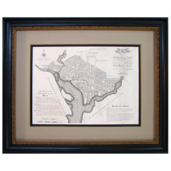
- Plan for the City of Washington by Andrew Ellicott, Antique Print, 19th CenturyLocated in Colorado Springs, COBy Andrew Ellicott (1754-1820) and Pierre Charles L'Enfant (1754-1825). Plan of the City of Washington. Published by Thackara & Vallance, Philadelphia, 1792. Later impression printed on 19th century wove paper. This is a fine 19th century printing of the "official" plan of Washington, D.C. First printed in 1792 by the original publishers, Thackara & Vallance in Philadelphia, this is a later 19th century printing of the fifth recorded engraving of the L’Enfant / Ellicott city plan. The first three issues of this city plan were in published in periodicals, making the fifth edition only the second separately-issued engraving of the plan. In full, the title reads, “Plan of the City of Washington in the Territory of Columbia, ceded by the States of Virginia and Maryland to the United States of America and by them established as the Seat of their Government after the year 1800.” The national capital city is laid out according to a plan originally proposed by Pierre Charles L'Enfant and modified by Andrew Ellicott. L'Enfant was born in Paris, where he trained to be an architect. He came to America in 1777, and served under George Washington as an engineer during the Revolutionary War. In 1791, Washington asked L'Enfant to design the new capital city in the District of Columbia. However, trouble arose between the city and L'Enfant. The City Commissioner needed a finished, printed copy of the plan in order to sell building lots but L'Enfant worked slowly and released only incomplete plans, and proved to be quite obstinate. On instruction from President Washington...Category
Antique Late 19th Century American Maps
MaterialsPaper
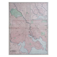
- Large Original Antique City Plan of Baltimore, USA, 1894By Rand McNally & Co.Located in St Annes, LancashireFabulous colorful map of Baltimore Original color By Rand, McNally & Co. Published, 1894 Unframed Free shipping.Category
Antique 1890s American Maps
MaterialsPaper
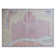
- Large Original Antique City Plan of Detroit, USA, 1894By Rand McNally & Co.Located in St Annes, LancashireFabulous colorful map of Detroit Original color By Rand, McNally & Co. Published, 1894 Unframed Free shipping.Category
Antique 1890s American Maps
MaterialsPaper
- Plan of Paris, France, by A. Vuillemin, Antique Map, 1845Located in Colorado Springs, COThis large and detailed plan of Paris was published by Alexandre Vuillemin in 1845. The map conveys a wonderful amount of information and is decorated throughout with pictorial vigne...Category
Antique 1840s American Maps
MaterialsPaper


Recently Viewed
View AllMore Ways To Browse
Large Old Map
17th Century Scottish Furniture
Antique Map Of New Hampshire
Map Of Utah
Royal Picardie
Catalonia Map
Kiels Antiques
Atlas Indu
Covens & Mortier On Sale
Cyclades Map
Matthew Seutter On Sale
Rand Mcnally Map Of Kansas
Sumba Map
Vincenzo Coronelli On Sale
Antique Cabbage Cutter
Antique Map Of Shanghai
Antique Maps Denver
Britton And Rey Lithograph