Items Similar to Attractive Antique Map showing Denmark and part of Sweden and Germany c.1750


Want more images or videos?
Request additional images or videos from the seller
1 of 7
Attractive Antique Map showing Denmark and part of Sweden and Germany c.1750
About the Item
Antique map titled 'Nieuwe Kaart van het Koninkryk van Deenemarken (..).' Attractive detailed map showing Denmark and a part of Sweden and Germany. Title in block-style cartouche with a simple compass rose. Source unknown, to be determined.
Artists and Engravers: Made by 'Isaak Tirion' after an anonymous artist. Made by 'Isaak Tirion' after an anonymous artist. Isaak Tirion, a Dutch publisher in Amsterdam, was born 1705. He produced serveral Atlases and Dutch town plans. The maps mainly based on those of Guillaume de l'Isle. He died in 1765.
Condition: Good, given age. Top edge browned. Original folds as issued. General age-related toning and/or occasional minor defects from handling. The margin on the lower right side, outside the image is very tight. Please study image carefully.
Date: c.1750
Overall size: 39 x 31 cm.
Image size: 0.001 x 34.2 x 28.2 cm.
We sell original antique maps to collectors, historians, educators and interior decorators all over the world. Our collection includes a wide range of authentic antique maps from the 16th to the 20th centuries. Buying and collecting antique maps is a tradition that goes back hundreds of years. Antique maps have proved a richly rewarding investment over the past decade, thanks to a growing appreciation of their unique historical appeal. Today the decorative qualities of antique maps are widely recognized by interior designers who appreciate their beauty and design flexibility. Depending on the individual map, presentation, and context, a rare or antique map can be modern, traditional, abstract, figurative, serious or whimsical. We offer a wide range of authentic antique maps for any budget.
- Creator:Isaak Tirion (Artist)
- Dimensions:Height: 12.21 in (31 cm)Width: 15.36 in (39 cm)Depth: 0 in (0.01 mm)
- Materials and Techniques:
- Period:
- Date of Manufacture:circa 1750
- Condition:
- Seller Location:Langweer, NL
- Reference Number:
About the Seller
5.0
Platinum Seller
These expertly vetted sellers are 1stDibs' most experienced sellers and are rated highest by our customers.
Established in 2009
1stDibs seller since 2017
1,946 sales on 1stDibs
Typical response time: <1 hour
- ShippingRetrieving quote...Ships From: Langweer, Netherlands
- Return PolicyA return for this item may be initiated within 14 days of delivery.
More From This SellerView All
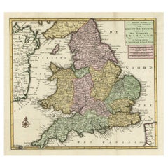
- Antique Map of the South Part of Great Britain by Tirion, c.1750By Isaak TirionLocated in Langweer, NLAntique map titled 'Nieuwe Kaart van 'T Zuider Gedeelte van Groot Britannie behelzende Het Koningryk Engeland (..).' Attractive map showing the south part of Great Britain; the K...Category
Antique 18th Century Maps
MaterialsPaper
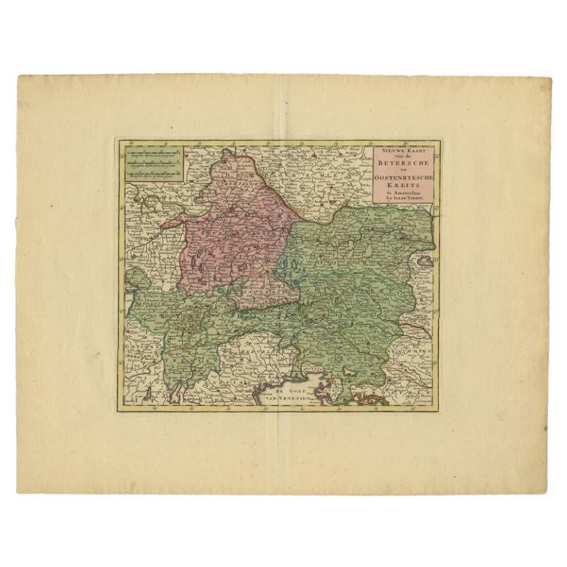
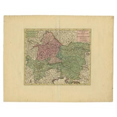
- Attractive Detailed Authentic Map Showing Bavaria, Germany and Austria, c.1740Located in Langweer, NLAntique map titled 'Nieuwe Kaart van de Beyersche en Oostenryksche Kreits (..).' Attractive detailed map showing Bavaria, Germany and Austria. Source unknown, to be determined. Ar...Category
Antique 18th Century Maps
MaterialsPaper
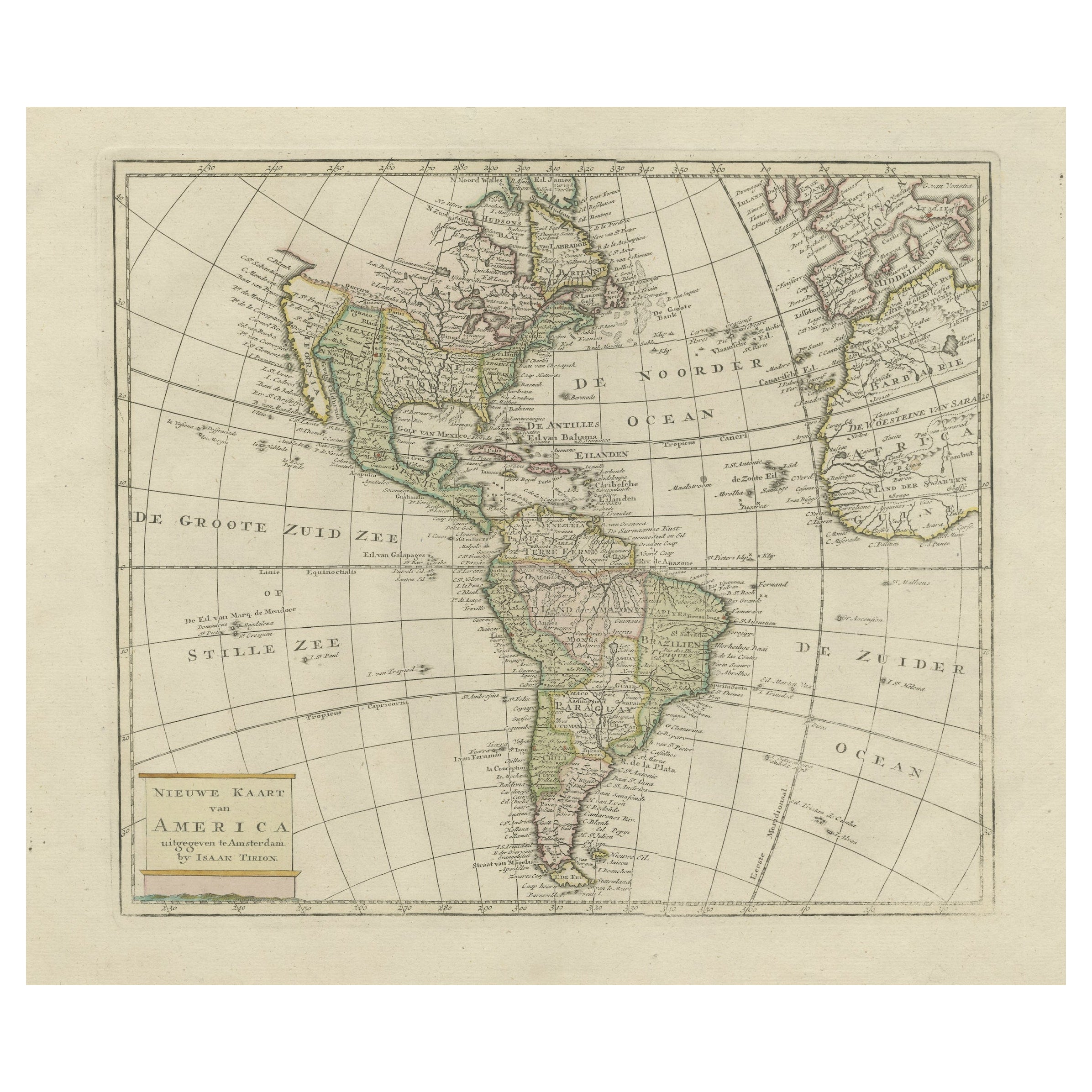
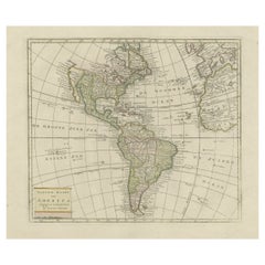
- Original Antique Map of North and South America in Attractive Old ColoringBy Isaak TirionLocated in Langweer, NLAntique map titled 'Nieuwe Kaart van America'. Beautiful map of America. The fabled Quivira is used to name a large mountain range placed just north of Mexico. Published by I. Tirion...Category
Antique Mid-18th Century Maps
MaterialsPaper
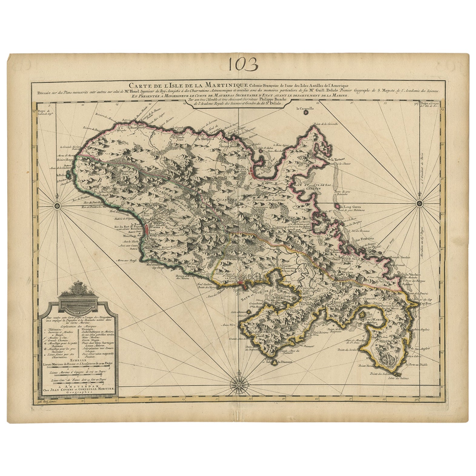
- Antique Map of Martinique, Showing Roads, Houses, Sugar Plantations, etc. c.1750Located in Langweer, NLAntique map titled 'Carte de l'Isle de la Martinique'. Detailed map of Martinique. Shows hilly terrain, forests, roads, houses, and even the sugar plantations. The island was to ...Category
Antique 18th Century Maps
MaterialsPaper
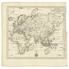
- Antique Map of the Eastern Part of the World by Tirion, 1755By Isaak TirionLocated in Langweer, NLAntique map titled 'Nieuwe Kaart van het Oostelykste Deel der Weereld, dienende tot Aanwyzing van de Scheepstogten der Nederlanderen naar Oostindië'. Australia (Nieuw Holland) shown ...Category
Antique Mid-18th Century Dutch Maps
MaterialsPaper
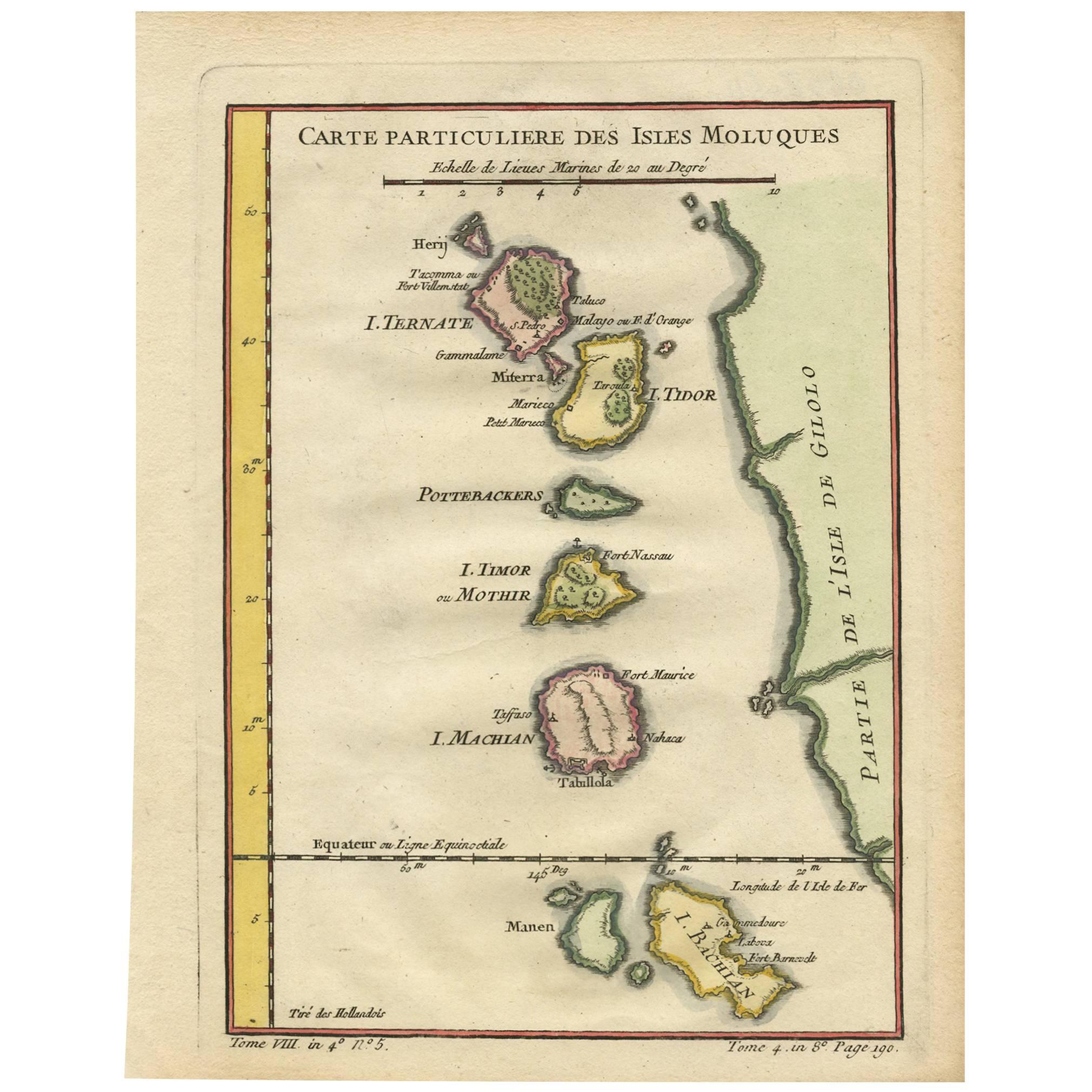
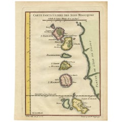
- Antique Map of the Moluques Islands, Part of Indonesia, circa 1750Located in Langweer, NLMap of the Moluques (also known as the Moluccas, Moluccan Islands or simply Maluku). Depicts the islands of Herij, Ternate, Tidor, Pottebackers, Timor, Machian and Bachian.Category
Antique Mid-18th Century Maps
MaterialsPaper

You May Also Like
- Original Antique Map of Sweden and Norway, Grattan and Gilbert, 1843Located in St Annes, LancashireGreat map of Sweden and Norway Drawn and engraved by Archer Published by Grattan and Gilbert Original color Unframed.Category
Antique 1840s English Other Maps
MaterialsPaper
- Original Antique Map of Sweden, Engraved by Barlow, 1806Located in St Annes, LancashireGreat map of Sweden Copper-plate engraving by Barlow Published by Brightly & Kinnersly, Bungay, Suffolk. 1806 Unframed.Category
Antique Early 1800s English Maps
MaterialsPaper
- England, Scotland & Ireland: A Hand Colored Map of Great Britain by TirionBy Isaak TirionLocated in Alamo, CAThis is a hand-colored double page copperplate map of Great Britain entitled "Nieuwe Kaart van de Eilanden van Groot Brittannien Behelzende de Kon...Category
Antique Mid-18th Century Dutch Maps
MaterialsPaper
- Antique Map of Principality of MonacoBy Antonio Vallardi EditoreLocated in Alessandria, PiemonteST/619 - "Old Geographical Atlas of Italy - Topographic map of ex-Principality of Monaco" - ediz Vallardi - Milano - A somewhat special edition ---Category
Antique Late 19th Century Italian Other Prints
MaterialsPaper
- Original Antique Map of Ireland- Tipperary and Waterford. C.1840Located in St Annes, LancashireGreat map of Tipperary and Waterford Steel engraving Drawn under the direction of A.Adlard Published by How and Parsons, C.1840 Unframed.Category
Antique 1840s English Maps
MaterialsPaper
- Original Antique Map of Spain and Portugal, circa 1790Located in St Annes, LancashireSuper map of Spain and Portugal Copper plate engraving by A. Bell Published, circa 1790. Unframed.Category
Antique 1790s English Other Maps
MaterialsPaper


Recently Viewed
View AllMore Ways To Browse
German C
Swedish Modern Antiques
Swedish And Danish Antiques
Danish Antique And Modern
Town Plan
Danish Server
German 18th C
Compass Map
Antique Tires
Tire Antique
Danish Modern Server
Rare Compass
Compass Antique Map
Antique Map Compass
Antique Compass Map
Compass 18th Century
18th Century Compass
Historical Maps Germany