Items Similar to Detailed Map of Arabian Peninsula and Canaan, Highlighting Biblical Territories


Want more images or videos?
Request additional images or videos from the seller
1 of 9
Detailed Map of Arabian Peninsula and Canaan, Highlighting Biblical Territories
About the Item
This antique map, titled "Terre de Chanaan ou Terre Promise a Abraham," is a finely detailed copper-engraved map created around 1750 by Delamarche in Paris, based on earlier works by Sanson and R. de Vaugondy. It prominently features the biblical land of Canaan, promised to Abraham, and is enhanced with hand-applied color highlighting regional boundaries.
The map integrates two significant insets: "Carte des Voiages d'Abraham" measuring 10.04 x 10.83 inches (25.5 x 27.5 cm), which traces the journeys of Abraham across the region, and "Disposition du Camp des Israelites," approximately 5.91 x 5.71 inches (15 x 14.5 cm), depicting the layout of the Israelites' camp. There is an illustration of the Ark of the Covenant in the lower-right corner. Measuring 16.73 x 21.85 inches (42.5 x 55.5 cm) in total, this historical piece exhibits some signs of aging with minor wear and occasional spotting, reflecting its rich history and antiquity. The central fold mark is typical of maps of this era, indicating it was likely housed in a bound atlas. This map is a captivating artifact, offering a glimpse into the geographical understanding and biblical interpretations of the mid-18th century.
The map is associated with the works of Robert de Vaugondy and Nicolas Sanson, two significant figures in the history of cartography, and was published by Charles François Delamarche, a notable French geographer and mapmaker from Paris.
Nicolas Sanson (1600-1667), often referred to as the "father of French cartography," was a pioneering figure in 17th-century French mapmaking. His work was highly influential and helped to establish a more scientific approach to mapmaking in France. Sanson's maps were known for their detailed accuracy and clear presentation, which helped to make them standard references in their time.
Robert de Vaugondy family, Gilles (1688-1766) and Didier (1723-1786), were prominent French cartographers in the 18th century who inherited the vast collection of map plates from the Sanson family. They revised and updated these maps to reflect new geographical knowledge and also produced their own original works. The Vaugondys were appointed as the official geographers to the French king, which underscores the significance and authority of their work in their era.
Charles François Delamarche (1740-1817) took over the Vaugondy publishing house in the late 18th century. He continued the tradition of producing high-quality maps and globes and was also known for innovating with educational products, including thematic and celestial maps. Delamarche's work represents a bridge between the meticulous detail of the Enlightenment and the growing public and educational interest in geographical knowledge during the French Revolution and Napoleonic eras.
Together, these figures represent a lineage of cartographic excellence, contributing to the evolution of mapmaking from a craft to a science, significantly influencing both the art and accuracy of maps used during their times. The map in question reflects this rich tradition and expertise, combining detailed cartographic information with historical and biblical references.
Antique maps of the region depicted in the map, which includes the Arabian Peninsula and the biblical lands often referred to as Canaan, appeal to collectors and enthusiasts for various historical and cultural reasons. Some of the main places and names that are popular in this context include:
1. Jerusalem - Often a central feature in maps of this area due to its profound historical and religious significance.
2. Mecca and Medina - These cities are of immense importance in Islamic tradition and history, making maps featuring them highly sought after.
3. The Red Sea - Often prominently featured in maps of the Arabian Peninsula, significant for its historical trade routes.
4. Sinai Peninsula - A key geographical and historical region connecting Africa and Asia, often noted in maps for its biblical significance, including Mount Sinai.
5. The Nile River - Maps featuring the Nile are popular due to the river's historical importance to civilizations in Egypt and its biblical associations.
6. Babylon - Located in modern-day Iraq, Babylon is of great historical and cultural interest, especially for its biblical connections.
7. Damascus - As one of the oldest continuously inhabited cities in the world, Damascus holds a special place in historical maps.
8. Petra - The ancient city of Petra, located in modern-day Jordan, is often featured due to its archaeological significance and its dramatic architecture.
The decorative elements, such as cartouches and illustrations depicting biblical scenes or historical figures, add to the desirability of these maps.
- Dimensions:Height: 21.86 in (55.5 cm)Width: 16.74 in (42.5 cm)Depth: 0 in (0.02 mm)
- Materials and Techniques:Paper,Engraved
- Period:1750-1759
- Date of Manufacture:circa 1750
- Condition:Condition is fair. The map is worn and short on the margins. The borders are hand-colored. Folding line in middle as issued. All text and images still sharp. This map is showing a lot of patina. Please study the images carefully.
- Seller Location:Langweer, NL
- Reference Number:Seller: BG-138261stDibs: LU3054341112362
About the Seller
5.0
Recognized Seller
These prestigious sellers are industry leaders and represent the highest echelon for item quality and design.
Gold Seller
Premium sellers maintaining a 4.3+ rating and 24-hour response times
Established in 2009
1stDibs seller since 2017
2,467 sales on 1stDibs
Typical response time: 1 hour
- ShippingRetrieving quote...Shipping from: Langweer, Netherlands
- Return Policy
Authenticity Guarantee
In the unlikely event there’s an issue with an item’s authenticity, contact us within 1 year for a full refund. DetailsMoney-Back Guarantee
If your item is not as described, is damaged in transit, or does not arrive, contact us within 7 days for a full refund. Details24-Hour Cancellation
You have a 24-hour grace period in which to reconsider your purchase, with no questions asked.Vetted Professional Sellers
Our world-class sellers must adhere to strict standards for service and quality, maintaining the integrity of our listings.Price-Match Guarantee
If you find that a seller listed the same item for a lower price elsewhere, we’ll match it.Trusted Global Delivery
Our best-in-class carrier network provides specialized shipping options worldwide, including custom delivery.More From This Seller
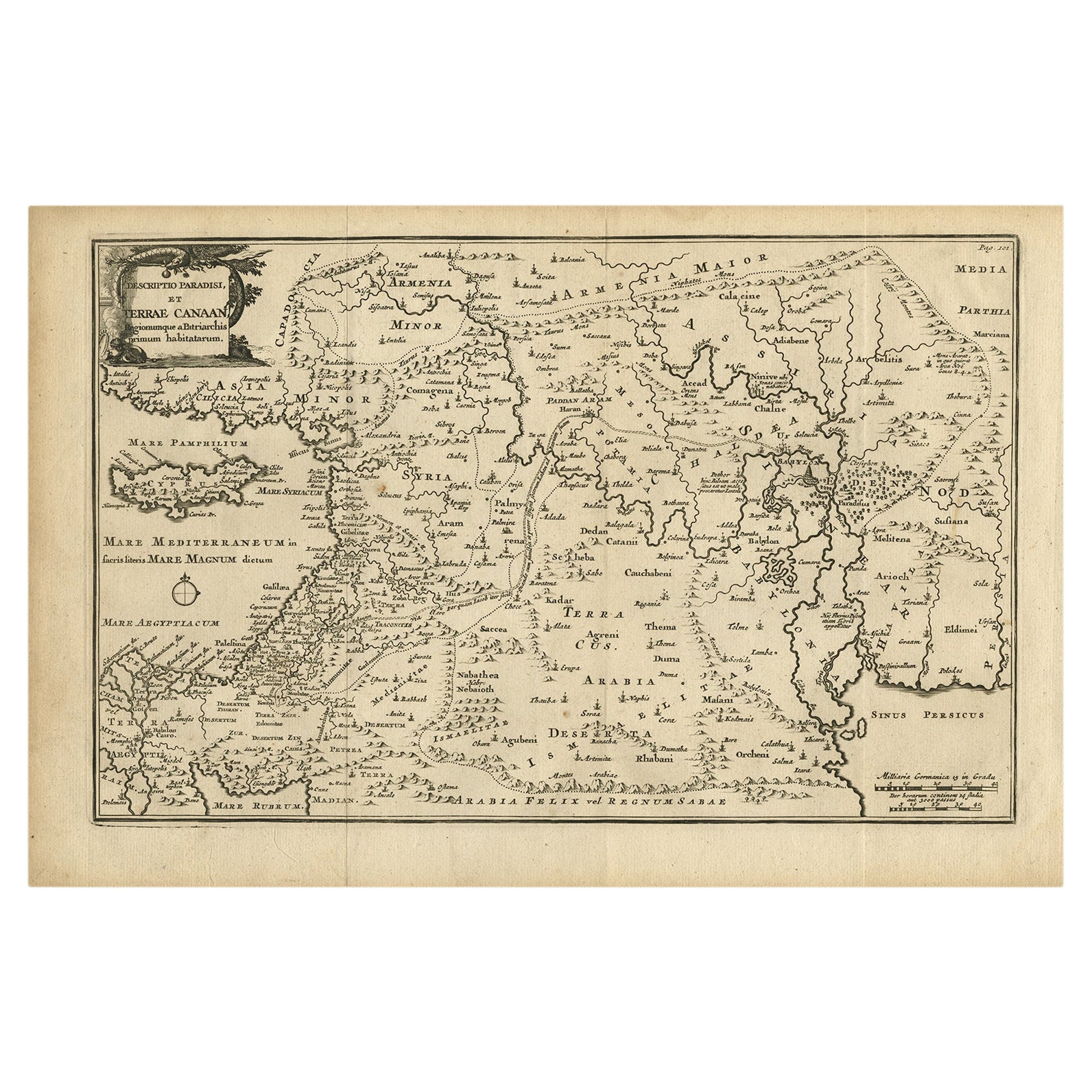
View AllOriginal Antique Map of Canaan, Armenia, Syria, Mesopotamia and Arabia, 1709
Located in Langweer, NL
Antique map titled 'Descriptio Paradisi et Terrae Canaan'.
Original antique map of Canaan, Armenia, Syria, Mesopotamia and Arabia. It displays the Middle East from the eastern Mediterranean Sea to the Persian Gulf...
Category
Antique Early 1700s Maps
Materials
Paper
$635 Sale Price
20% Off
Free Shipping
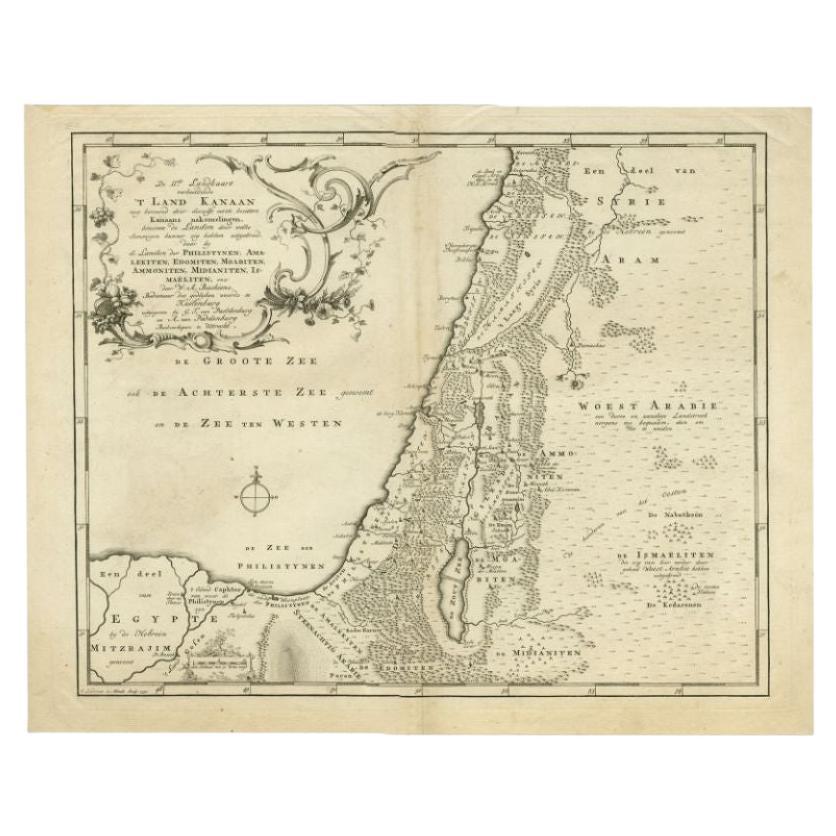
Antique Map of the Biblical Land of Canaan by Lindeman, c.1758
Located in Langweer, NL
Antique map titled 'De IIde Landkaart verbeeldende t'Land Kanaan nog bewoond door deszelfs eerste bezitters (..).' - Map of the biblical Land of Canaan. With large title cartouche, c...
Category
Antique 18th Century Maps
Materials
Paper
$188 Sale Price
20% Off
Antique Map of the Arabian Peninsula by Bonne 'c.1780'
Located in Langweer, NL
Antique map titled 'Carte de l'Arabie, du Golfe Persique, et de la Mer Rouge (..)'. Original antique map of the Arabian Peninsula, including the horn...
Category
Antique Late 18th Century Maps
Materials
Paper

$517 Sale Price
20% Off
Antique Map of the Arabian Peninsula by Franceschini, '1739'
Located in Langweer, NL
Antique map titled 'Conventus et Residentiae'. Rare map of the Arabian Peninsula. This map originates from 'Provinciarum et Conventum Fratrum Discalc...
Category
Antique Mid-18th Century Maps
Materials
Paper

$529 Sale Price
40% Off
Antique Map of the Arabian Peninsula by Bonne 'c.1780'
Located in Langweer, NL
Antique map titled 'Carte de l'Arabie, du Golfe Persique, et de la Mer Rouge (..)'. Original antique map of the Arabian Peninsula, including the horn...
Category
Antique Late 18th Century Maps
Materials
Paper

$470 Sale Price
20% Off
Antique Map of the Arabian Peninsula by Bellin 'c.1740'
Located in Langweer, NL
Antique map titled 'Carte de la Coste d'Arabie, Mer Rouge et Golfe de Perse'. Original antique map of the Arabian Peninsula, labes both Mecca and Med...
Category
Antique Mid-18th Century Maps
Materials
Paper

$470 Sale Price
20% Off
You May Also Like
1890 "Map of Oregon, Kansas, California, and the Territories" by S. A. Mitchell
By Samuel Augustus Mitchell 1
Located in Colorado Springs, CO
Presented is an 1890 map "Map of Oregon, Kansas, California, and the Territories" by S. A. Mitchell Jr. The map was issued in the atlas “Mitchell's New Intermediate Geography” publis...
Category
Antique 1890s American Victorian Maps
Materials
Paper

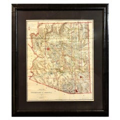
1896 "Territory of Arizona" Map, Published by the General Land Office
Located in Colorado Springs, CO
Presented is an attractive "Territory of Arizona” map, from the “Report of the Governor of Arizona to the Secretary of the Interior." First published in 1894, this 1896 edition was r...
Category
Antique 1890s Maps
Materials
Paper
Map Holy Promise Land Canaan Richard Palmer Richard Blome 1687 Joseph Moxon
Located in BUNGAY, SUFFOLK
Canaan comonly called the Holy Land or the Land of Promise, being the Possesion of the Israelites & travelled through by Our Lord & Saviour Iesus Christ and his Apostles. Engraven by Richard Palmer for Richard Blome. 1687
Blome, Richard, 1641-1705. London. 283 x 452 mm. Copperplate.
Probably from an English Bible...
Category
Antique 17th Century British Baroque Maps
Materials
Paper

Lawrence of Arabia
Located in London, GB
Original US film poster for the films US release in 1962.
This epic British film is based on the life of T. E. Lawrence. It was directed by David Lean and produced by Sam Spiegel. Th...
Category
Vintage 1960s American Posters
Materials
Paper
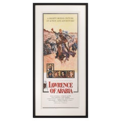
$5,529
1854 Map of Massachusetts, Connecticut and Rhode Island, Antique Wall Map
Located in Colorado Springs, CO
This striking wall map was published in 1854 by Ensign, Bridgman & Fanning and has both full original hand-coloring and original hardware. This impression is both informative and highly decorative.
The states are divided into counties, outlined in red, green, and black, and subdivided into towns. Roads, canals, and railroad lines are prominently depicted, although they are not all labeled. The mapmakers also marked lighthouses, banks, churches, and prominent buildings, with a key at right. The map is an informative and comprehensive overview of the infrastructural development of New England prior to the Civil War. Physical geographies depicted include elevation, conveyed with hachure marks, rivers and lakes. The impression features an inset map of Boston...
Category
Antique 19th Century American Maps
Materials
Paper

Map of Lancashire
Located in Cheshire, GB
Saxton Map of Lancashire hand coloured. Encased in an ebonised frame.
Dimensions
Height 21 Inches
Width 24 Inches
Depth 1 Inches
Category
Early 20th Century British Maps
Materials
Paper

Recently Viewed
View AllMore Ways To Browse
Ancient Babylon
Antique Silver Napkin Holders
Antique Silver Nutcracker
Antique Silver Thimble
Antique Singer Machine
Antique Spongeware Bowl
Antique Sterling Match Safe
Antique Sterling Silver Punch Ladle
Antique Sterling Walking Cane
Antique Stieff Sterling Silver
Antique Table Northern Ireland
Antique Tavern Chairs
Antique Three Legged Chair
Antique Victorian Gentlemans Chair
Antique Victorian Sampler
Antique Wallpaper Screen
Antique Wheel Barrel
Antique White Washed Dining Table