Items Similar to Frederic de Wit Map of Palestine – Terra Sancta, Amsterdam c.1670


Video Loading
Want more images or videos?
Request additional images or videos from the seller
1 of 14
Frederic de Wit Map of Palestine – Terra Sancta, Amsterdam c.1670
$1,504.26
£1,122.42
€1,260
CA$2,097.62
A$2,297.99
CHF 1,200.42
MX$27,626.46
NOK 15,007.39
SEK 14,154.36
DKK 9,594.64
About the Item
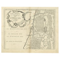
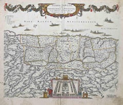
Terra Sancta sive Promissionis, olim Palestina – hand-coloured copper-engraved map of the Holy Land by Frederic de Wit, Amsterdam, circa 1670
This impressive folio sheet, bearing the full Latin title “TERRA SANCTA, sive PROMISSIONIS, olim PALESTINA,” was engraved and published by the Dutch Golden-Age cartographer and print-seller Frederic de Wit (1629–1706) around 1670, shortly after he took over the plates of Willem Jansz. Blaeu and Johannes Janssonius and began issuing his own atlases from the Kalverstraat in Amsterdam. De Wit’s work is renowned for its crisp line, balanced lettering, and exuberant baroque ornament, all of which are on display here.
The geography follows the traditional orientation with the Mediterranean at the top (labelled MARE MAGNUM sive MEDITERRANEUM) and the River Jordan flowing into the Dead Sea, while the interior is divided into the territories of the Twelve Tribes of Israel, making the map valuable to both biblical scholars and collectors of Judaica. A lively procession of galleons and sea-creatures animates the coastal waters, echoing the maritime power of the Dutch Republic at the time the map was printed. Across the upper border a floral swag held aloft by winged putti provides a joyful frame for the title cartouche.
Most striking is the large inset across the bottom centre: an architectural bird’s-eye plan of the Tabernacle in the Wilderness, complete with the Ark of the Covenant, the altar of burnt offerings, and the arrangement of the encamped tribes. This vignette, rarely found so elaborately rendered, underscores the map’s dual purpose as both geographical reference and didactic aid for readers of the Old Testament. Its presence sets De Wit’s plate apart from earlier Holy Land maps by Ortelius, Visscher, and Janssonius, and makes the print a favourite with collectors seeking decorative wall pieces that also carry deep iconographic meaning.
Condition: strong, even impression on sturdy laid paper with a clearly visible watermark; original hand colour remains fresh and translucent. Old vertical centre-fold as issued; light age-tone and a few scattered, faint fox spots confined to blank margins; two tiny edge nicks skilfully closed on the verso with thin Japanese tissue, well away from the printed border. No repairs or abrasions inside the engraved area. Graded Very Good+ for a work now more than 350 years old.
Tip on framing: float-mount the sheet in an acid-free 100 % cotton rag mat to reveal the full plate-mark and deckled edge, then glaze with UV-filtering acrylic or glass to shield the delicate water-based colours. A simple ebonised or medium-walnut moulding complements both period and modern interiors while letting the rich baroque cartouches and hand colouring command attention.
Keywords: Holy Land map, Terra Sancta, Palestina, Frederic de Wit, 17th-century Dutch cartography, antique Judaica, Twelve Tribes, Tabernacle plan, Jerusalem, biblical Israel, decorative copper engraving, Amsterdam atlas, baroque cartouche, Mediterranean Sea, collectible vintage print, Dutch Golden Age.
- Dimensions:Height: 18.12 in (46 cm)Width: 21.93 in (55.7 cm)Depth: 0.01 in (0.2 mm)
- Materials and Techniques:Paper,Engraved
- Place of Origin:
- Period:Late 17th Century
- Date of Manufacture:circa 1670
- Condition:Condition: strong, even impression on sturdy laid paper with a clearly visible watermark; original hand colour remains fresh and translucent. Old vertical centre-fold as issued; light age-tone and a few scattered, faint fox spots confined to margins.
- Seller Location:Langweer, NL
- Reference Number:Seller: BG-140931stDibs: LU3054345555772
About the Seller
5.0
Recognized Seller
These prestigious sellers are industry leaders and represent the highest echelon for item quality and design.
Platinum Seller
Premium sellers with a 4.7+ rating and 24-hour response times
Established in 2009
1stDibs seller since 2017
2,653 sales on 1stDibs
Typical response time: <1 hour
- ShippingRetrieving quote...Shipping from: Langweer, Netherlands
- Return Policy
Authenticity Guarantee
In the unlikely event there’s an issue with an item’s authenticity, contact us within 1 year for a full refund. DetailsMoney-Back Guarantee
If your item is not as described, is damaged in transit, or does not arrive, contact us within 7 days for a full refund. Details24-Hour Cancellation
You have a 24-hour grace period in which to reconsider your purchase, with no questions asked.Vetted Professional Sellers
Our world-class sellers must adhere to strict standards for service and quality, maintaining the integrity of our listings.Price-Match Guarantee
If you find that a seller listed the same item for a lower price elsewhere, we’ll match it.Trusted Global Delivery
Our best-in-class carrier network provides specialized shipping options worldwide, including custom delivery.More From This Seller
View All17th-Century Map of the Latin Patriarchate of Jerusalem by Melchior Tavernier
Located in Langweer, NL
Title: 17th-Century Map of the Latin Patriarchate of Jerusalem by Melchior Tavernier
Description: This rare 17th-century map by Melchior Tavernier illustrates the geographical ext...
Category
Antique 1640s Maps
Materials
Paper
Antique Map of Northern Palestine with The Tribes of Israel. Dutch, 1763
Located in Langweer, NL
Antique Map of Northern Palestine with Tribal Divisions, Bachiene, 1763
The cartouche bears the title: “’t Noordelyke Gedeelte van het Geheel Palestina Benevens het Noordelyk en Zui...
Category
Antique 18th Century Dutch Maps
Materials
Paper
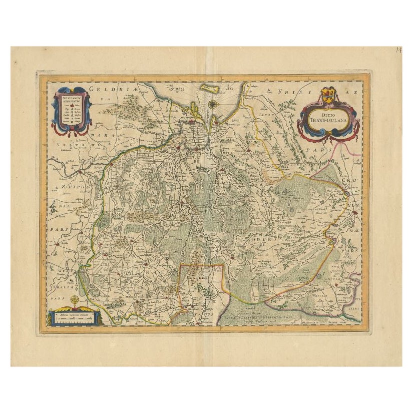
Antique Map of the Province of Overijssel by Janssonius, c.1650
Located in Langweer, NL
Antique map titled 'Ditio Trans-isulana'. Original antique map of the province of Overijssel, the Netherlands. With coat of arms and two decorative cartouches. Published by J. Jansso...
Category
Antique 17th Century Maps
Materials
Paper
$496 Sale Price
20% Off
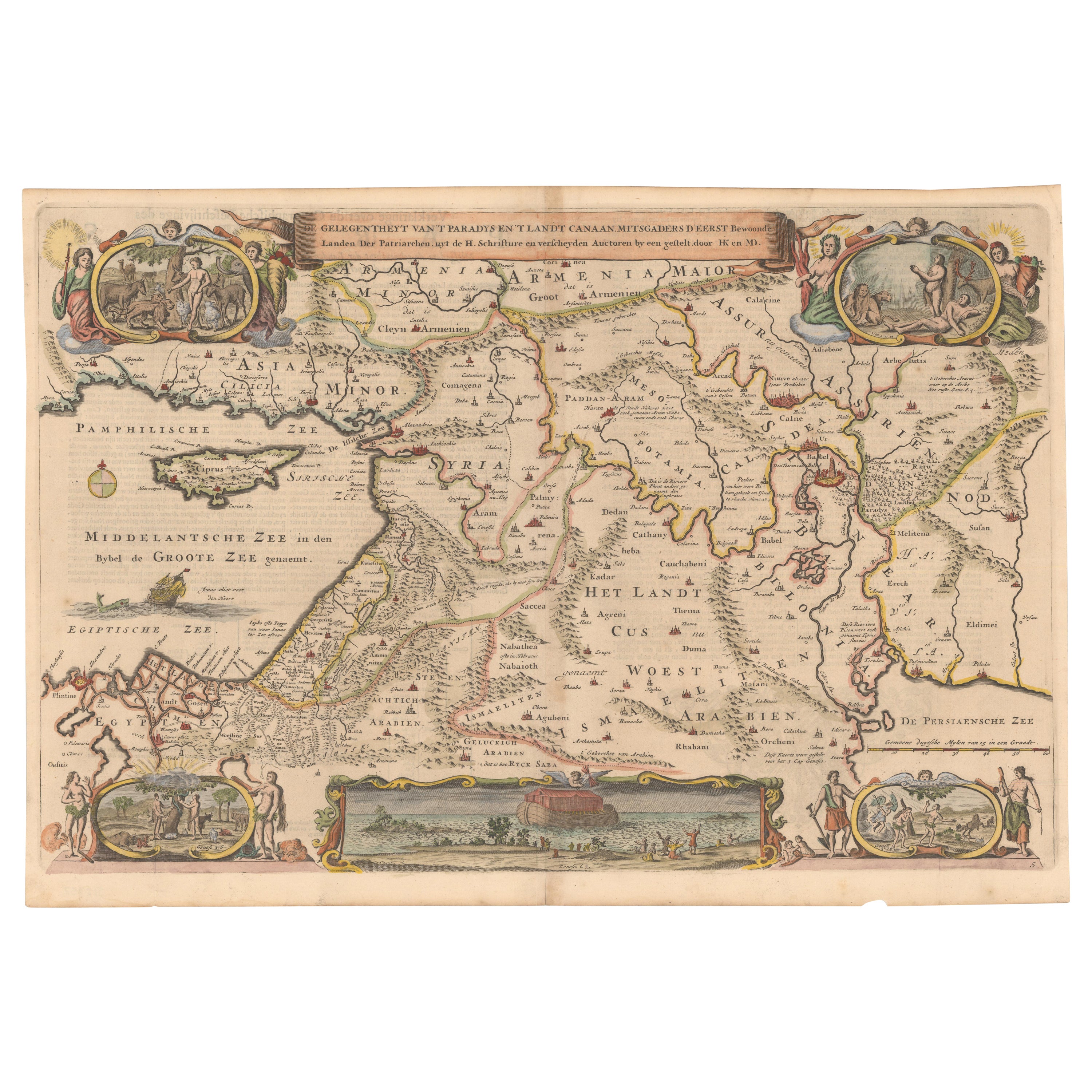
Circa 1686 Daniel Stoopendaal Map: Biblical Sites from Paradise to Canaan
Located in Langweer, NL
Circa 1686 Daniel Stoopendaal Map: Biblical Sites from Paradise to Canaan
This circa 1686 hand-colored map by Daniel Stoopendaal, titled "De Gelegentheyt van 't Paradys en 't Landt Canaan," beautifully illustrates the Middle East, extending from the Mediterranean to the Persian Gulf.
The map features numerous Biblical locations, such as the Garden of Eden, the wanderings of the Children of Israel, and the story of Jonas and the whale.
It is adorned with elaborate decorations, including a banner-style title cartouche and four corner vignettes depicting scenes from Genesis: Paradise, the creation of Adam and Eve, Eve offering the apple, and their expulsion from Eden.
The bottom center showcases a dramatic portrayal of Noah's Ark. Measuring 18.3 inches wide by 11.9 inches high, this first state map includes Dutch text on the reverse and is in good condition, with a crisp impression, light toning along the centerfold, and a small chip in the bottom margin.
Keywords:
- Daniel Stoopendaal map
- Biblical map
- Garden of Eden
- Land of Canaan
- Middle East historical map
- Noah's Ark map
- Adam and Eve
- 17th-century Bible...
Category
Antique 1680s Maps
Materials
Paper
$802 Sale Price
20% Off
1625 Petrus Plancius / Cloppenburg Map of the Holy Land with Biblical Vignettes
Located in Langweer, NL
1625 Petrus Plancius / Johannes Cloppenburg Map of the Holy Land with Biblical Vignettes
This exquisite 1625 map by Petrus Plancius and Johannes Cloppenburg represents the Holy Lan...
Category
Antique 1620s Maps
Materials
Paper
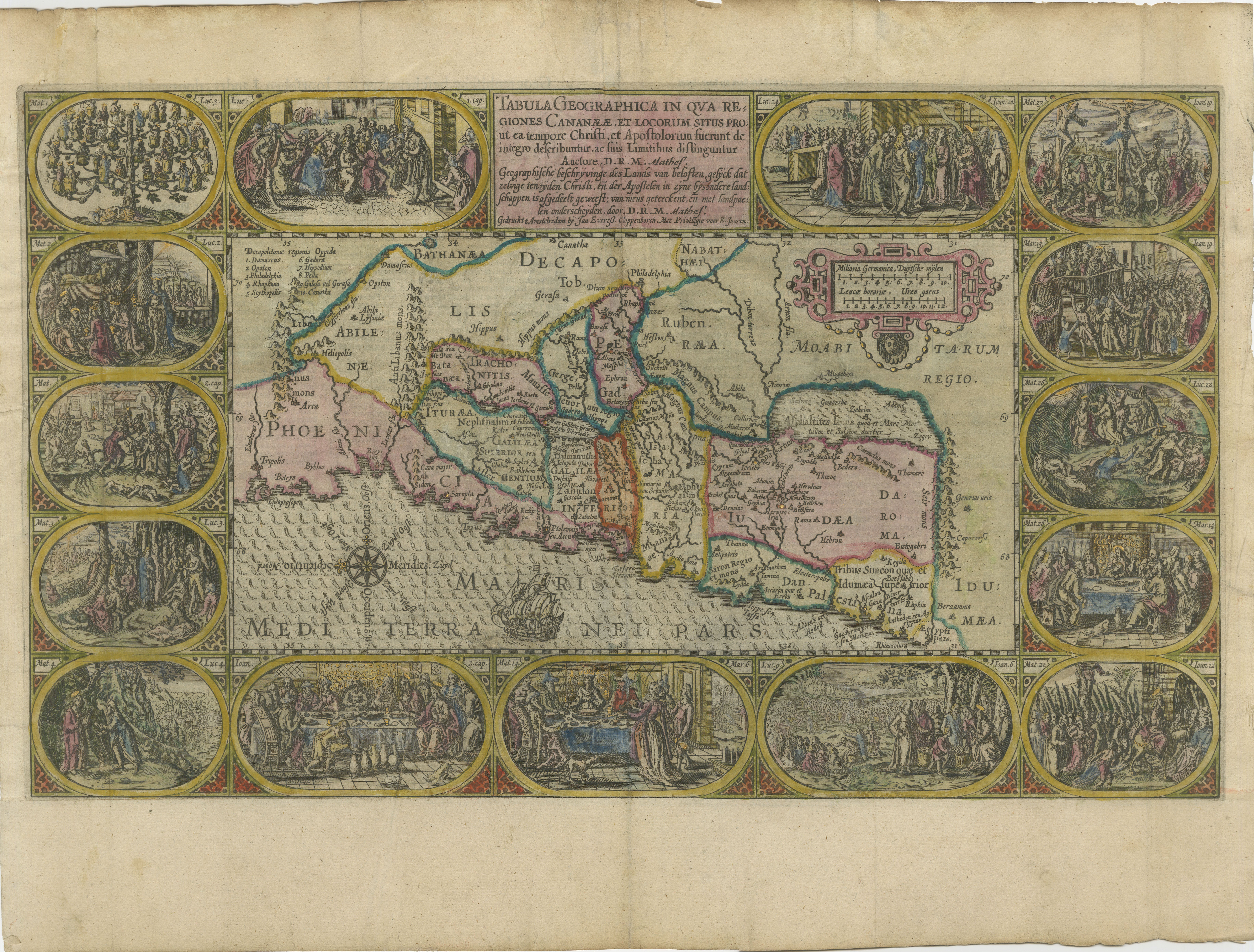
Antique Map of the Holy Land by Schut, 1710
Located in Langweer, NL
Antique map of the Holy Land titled 'Het Beloofde Landt Canaan.' Very detailed and decorative map of the Holy Land embellished with sailing ships and com...
Category
Antique 18th Century Maps
Materials
Paper

$401 Sale Price
20% Off
You May Also Like
17th Century Dutch Map of the Holy Land at the Time of Jesus by Visscher
By Nicolaus Visscher
Located in Alamo, CA
This detailed Dutch map entitled "Het Beloofe de Landt Canaan door wandelt van onsen Salichmaecker Iesu Christo, nessens syne Apostelen" by Nicolaes Visscher (1610-1679), published i...
Category
1660s Prints and Multiples
Materials
Engraving

1630 Pierre Petit map "Description du Gouvernement de la Capelle" Ric0010
Located in Norton, MA
1630 Pierre Petit map entitled
"Description du Gouvernement de la Capelle,"
Ric0010
Pierre Petit was the son of a minor provincial official in Montluçon. The town, in the Auver...
Category
Antique 17th Century Dutch Maps
Materials
Paper

1643 Willem&Joan Blaeu Map NW Flanders "Flandriae Teutonicae Pars Prientalior
Located in Norton, MA
1643 Willem and Joan Blaeu map of northwest Flanders, entitled
"Flandriae Teutonicae Pars Prientalior,"
Ric0012
" Authentic" - Map of the northwest Fl...
Category
Antique 17th Century Dutch Maps
Materials
Paper

Terra Sancta - Etching by Frederick de Wit - 1680ca
By Frederick de Wit
Located in Roma, IT
This double-page etching with contemporary coloring, entitled Terra Sancta, was realized by the cartographer Frederick de Wit for the famous Atlas published in Amsterdam in ca. 1680....
Category
1680s Modern Figurative Prints
Materials
Etching
1633 Map "La Souverainete De Sedan Et De Raucourt, Et La Prevoste Ric0011
Located in Norton, MA
1653 map entitled
"La Souverainete de Sedan et de Raucourt, et la Prevoste de Doncheri,"
Ric0011
Description:
Lovely map centered on Sedan and Doncheri and the Meuze River fr...
Category
Antique 17th Century Dutch Maps
Materials
Paper

1597 German Map of Alexandria by Georg Braun and Frans Hogenberg
By Georg Braun and Frans Hogenberg
Located in Chapel Hill, NC
1597 Map of Alexandria by Georg Braun and Frans Hogenberg, Germany. From "Civitas Orbis Terrarum", part 2, published in Cologne by Bertram Buchholz. Printed in 2 parts. Title: "Alexa...
Category
Antique 16th Century German Renaissance Maps
Materials
Paper

More Ways To Browse
Palestine Antique
Used Tabernacles
Antique Tabernacle
Sets Of Framed Bird Prints
Antique Ark
Antique Architectural Plans
Jerusalem Engraving
Antique Victorian Dining Tables
Italian Plastic Chairs
Black Crystal Glasses
French Mid Century Modern Rug
China Silk Rug
Chrome Glass Coffee Tables
Antique Italian Chairs
Antique Walnut Bar
Beni Ourain Rugs
French Iron And Glass Table
Glass Top Wood Base Coffee Tables