Items Similar to Hand-Colored Antique Map of part of Germany by M. Seutter, c. 1730


Want more images or videos?
Request additional images or videos from the seller
1 of 6
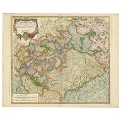
Hand-Colored Antique Map of part of Germany by M. Seutter, c. 1730
$558.16
$697.7020% Off
£424.29
£530.3720% Off
€472
€59020% Off
CA$784.41
CA$980.5120% Off
A$852.93
A$1,066.1620% Off
CHF 449.41
CHF 561.7620% Off
MX$10,360.63
MX$12,950.7920% Off
NOK 5,650.01
NOK 7,062.5120% Off
SEK 5,296.42
SEK 6,620.5320% Off
DKK 3,612.79
DKK 4,515.9820% Off
About the Item
Antique map titled 'Mappa Circuli Rhenani Superioris (..). Original map with hand coloring of part of Germany. It includes the region of Kassel, Göttingen, Eisenach, Schweinfurt, Wertheim, Darmstadt, Frankfurt, Mainz, Koblenz. Includes decorative cartouche, compass rose and coat of arms. Shows cities and towns, place names, rivers, forests and mountains. Published by M. Seutter.
- Creator:Matthew Seutter (Artist)
- Dimensions:Height: 20.67 in (52.5 cm)Width: 24.02 in (61 cm)Depth: 0.02 in (0.5 mm)
- Materials and Techniques:
- Period:
- Date of Manufacture:circa 1730
- Condition:Please study image carefully.
- Seller Location:Langweer, NL
- Reference Number:Seller: BGI-000891stDibs: LU305439112711
About the Seller
5.0
Recognized Seller
These prestigious sellers are industry leaders and represent the highest echelon for item quality and design.
Platinum Seller
Premium sellers with a 4.7+ rating and 24-hour response times
Established in 2009
1stDibs seller since 2017
2,696 sales on 1stDibs
Typical response time: <1 hour
- ShippingRetrieving quote...Shipping from: Langweer, Netherlands
- Return Policy
Authenticity Guarantee
In the unlikely event there’s an issue with an item’s authenticity, contact us within 1 year for a full refund. DetailsMoney-Back Guarantee
If your item is not as described, is damaged in transit, or does not arrive, contact us within 7 days for a full refund. Details24-Hour Cancellation
You have a 24-hour grace period in which to reconsider your purchase, with no questions asked.Vetted Professional Sellers
Our world-class sellers must adhere to strict standards for service and quality, maintaining the integrity of our listings.Price-Match Guarantee
If you find that a seller listed the same item for a lower price elsewhere, we’ll match it.Trusted Global Delivery
Our best-in-class carrier network provides specialized shipping options worldwide, including custom delivery.More From This Seller
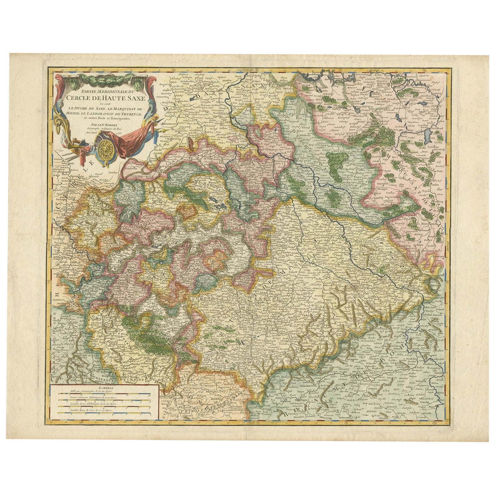
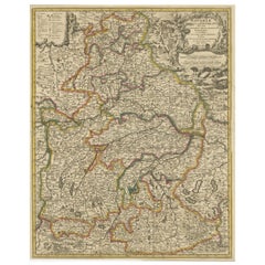
View AllNicely Colored Original Antique Map of Upper Saxony, Middle Germany, 1756
Located in Langweer, NL
Antique map titled 'Partie Meridionale du cercle de Haute Saxe (..)'.
Original antique map of upper Saxony, Germany. It was the name given to the majority of the German lands held by the House of Wettin, in what is now called Central Germany.
Artists and Engravers: Gilles Robert de Vaugondy (1688 - 1766), also known as Le Sieur or Monsieur Robert, and his son, Didier Robert de Vaugondy (c.1723 - 1786), were leading mapmakers in France during the 18th century. In 1757, they published The Atlas Universel, one of the most important atlases of the 18th century. To produce the atlas, the Vaugondys integrated older sources with more modern surveyed maps...
Category
Antique 1750s Maps
Materials
Paper
$1,087 Sale Price
20% Off
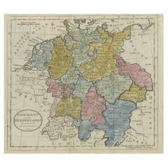
Antique Map of Northern Germany by M. Seutter, circa 1730
By Matthew Seutter
Located in Langweer, NL
Antique map titled 'Saxoniae Inferioris Circulus'. Old map of the northern part of Germany by M. Seutter. Covering the area of Lower Saxony, Mecklenburg-Vorpommern and Schleswig-Hols...
Category
Antique Mid-18th Century Maps
Materials
Paper

$558 Sale Price
20% Off
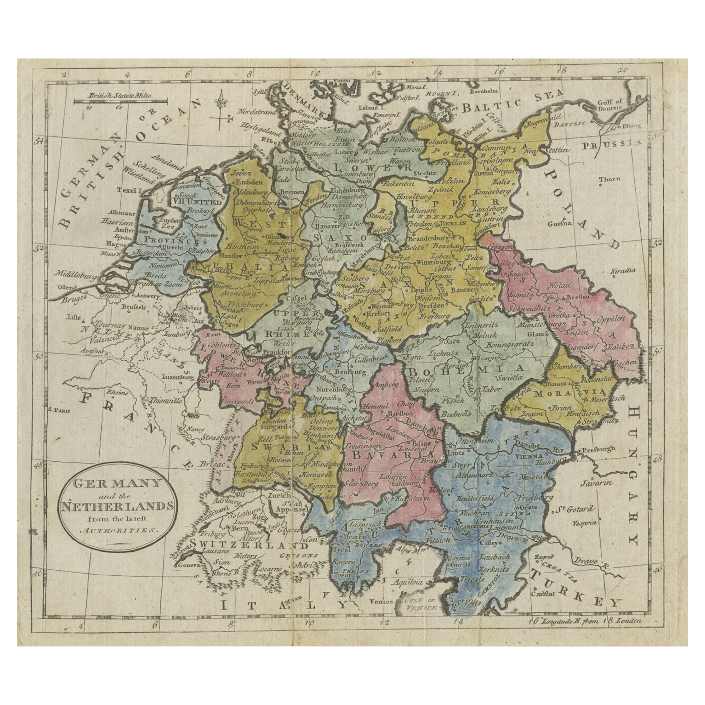
Antique Map of Germany, the Netherlands, Bohemia, Bavaria and Switzerland, 1785
Located in Langweer, NL
Antique map titled 'Germany and the Netherlands from the latest authorities'. Depicts Germany, the Netherlands and the surrounding region including Bohemia, Bavaria, and Switzerland....
Category
Antique 18th Century Maps
Materials
Paper
$132 Sale Price
20% Off
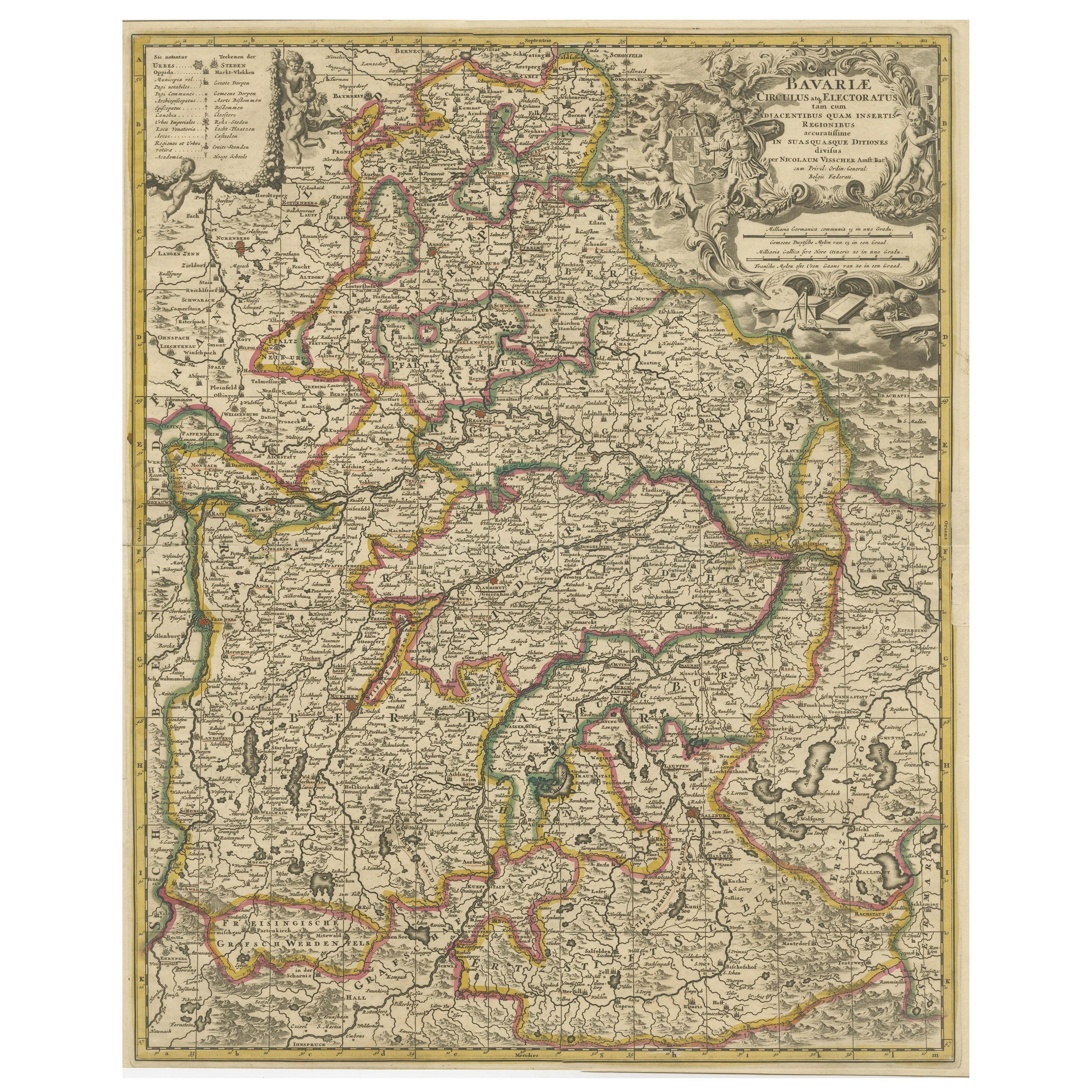
Antique Map of Bavaria, Bayern, with original Hand Coloring
Located in Langweer, NL
Antique map titled 'Bavariae Circulus atq Electoratus tam cum Adiacentibus quam insertis Regionibus'. Original old map of Bavaria, Bayern, Germany. The map stretches south to Innsbru...
Category
Antique Late 17th Century Maps
Materials
Paper
$444 Sale Price
20% Off
Antique Map of Germany by T. Kitchin, circa 1770
Located in Langweer, NL
Antique map titled 'An Accurate Map of Germany (..) '. Drawn from the best Authorities by T.Kitchin Geogr." Rare edition, drawn and etched by Thomas Kitchin, published, circa 1770.
Category
Antique Mid-18th Century Maps
Materials
Paper

$227 Sale Price
20% Off
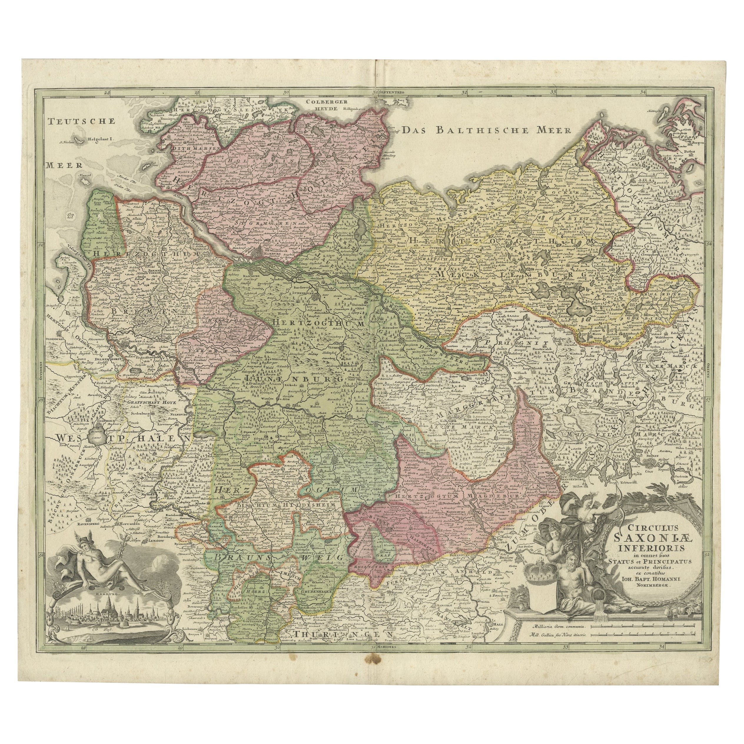
Antique Engraved Map of Saxonia in Northern Germany, ca.1721-1750
Located in Langweer, NL
Duitsland, Sassonia; Johannes Baptist Homann - Circulus Saxoniae Inferioris in omnes suos Status et Principatus accurate divisus ex conatibus -
A large map of Lower Saxony, exten...
Category
Antique Mid-18th Century Maps
Materials
Paper
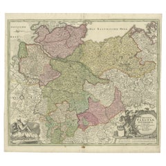
$804 Sale Price
20% Off
You May Also Like
West Germany: Original Hand Colored 17th Century Map by Johannes Janssonius
By Johannes Janssonius
Located in Alamo, CA
An original hand colored copperplate engraved map entitled in Latin "Archiepiscopatus Maghdeburgensis et Anhaltinus Ducatus cum terris adjacentibus", published in Amsterdam in 1640 i...
Category
Mid-17th Century Old Masters More Prints
Materials
Engraving

A Hand Colored 17th Century Janssonius Map of Prussia: Poland, N. Germany, etc.
By Johannes Janssonius
Located in Alamo, CA
An attractive hand-colored copperplate engraved 17th century map of Prussia entitled "Prussia Accurate Descripta a Gasparo Henneberg Erlichensi", published in Amsterdam by Joannes Janssonius in 1664. This very detailed map from the golden age of Dutch cartography includes present-day Poland, Latvia, Lithuania, Estonia and portions of Germany. This highly detailed map is embellished by three ornate pink, red, mint green and gold...
Category
Mid-17th Century Old Masters Landscape Prints
Materials
Engraving

Hand Colored 18th Century Homann Map of Austria Including Vienna & the Danube
By Johann Baptist Homann
Located in Alamo, CA
"Archiducatus Austriae inferioris" is a hand colored map of Austria created by Johann Baptist Homann (1663-1724) and published in Nuremberg, Germany in 1728 shortly after his death. ...
Category
Early 18th Century Old Masters Landscape Prints
Materials
Engraving

1790 Thomas Stackhouse Map, Entitled "Russia in Europe, " , Ric.a004
Located in Norton, MA
1790 Thomas Stackhouse map, entitled
"Russia in Europe"
Ric.a004
Stackhouse, Thomas
Russia in Europe [map]
London: T. Stackhouse, 1783. Map. Matted hand-colored copper engraving. Image size: 14.5 x 15.25 inches. Mat size: 22.75 x 23.75 inches. A beautiful example of this map of Eastern Europe...
Category
Antique 17th Century Unknown Maps
Materials
Paper

1853 Map of "Russia in Europe Including Poland" Ric.r016
Located in Norton, MA
Description
Russia in Europe incl. Poland by J Wyld c.1853
Hand coloured steel engraving
Dimension: Paper: 25 cm W x 33 cm H ; Sight: 22 cm W x 28 cm H
Condition: Good ...
Category
Antique 19th Century Unknown Maps
Materials
Paper

German Empire, Northern Part. Century Atlas antique vintage map
Located in Melbourne, Victoria
'The Century Atlas. German Empire, Northern Part.'
Original antique map, 1903.
Central fold as issued. Map name and number printed on the reverse corne...
Category
Early 20th Century Victorian More Prints
Materials
Lithograph

More Ways To Browse
Charles Rennie Mackintosh For Cassina
Glass Salt
Vintage Resin Tables
Antique English Country Furniture
Blue Kilim Vintage
Contemporary Side Tables And Stools
Decorative Wall Plate
Mid Century Modern Corner Chair
Dining Tables With Brass Inlay
Oak Mid Century Armchair
Solid Wood Side Table Stool
Antique Marble Top Hall Table
Bird And Butterfly
Old Carpet
Porcelain Modern Hand Painted
Bent Plywood
1960 Italian Dining Set
Italian Giltwood Table