Items Similar to Johnston Map of Greece & Crete 1897 – The Eastern Question Antique Map

Want more images or videos?
Request additional images or videos from the seller
1 of 10
Johnston Map of Greece & Crete 1897 – The Eastern Question Antique Map
$1,019.78
£758.14
€860
CA$1,413.24
A$1,575.49
CHF 821.68
MX$19,051.28
NOK 10,328.93
SEK 9,773.23
DKK 6,547.40
About the Item
Here’s a catalogue entry for your **Johnston map of Greece and Crete**:
---
**Main Title**
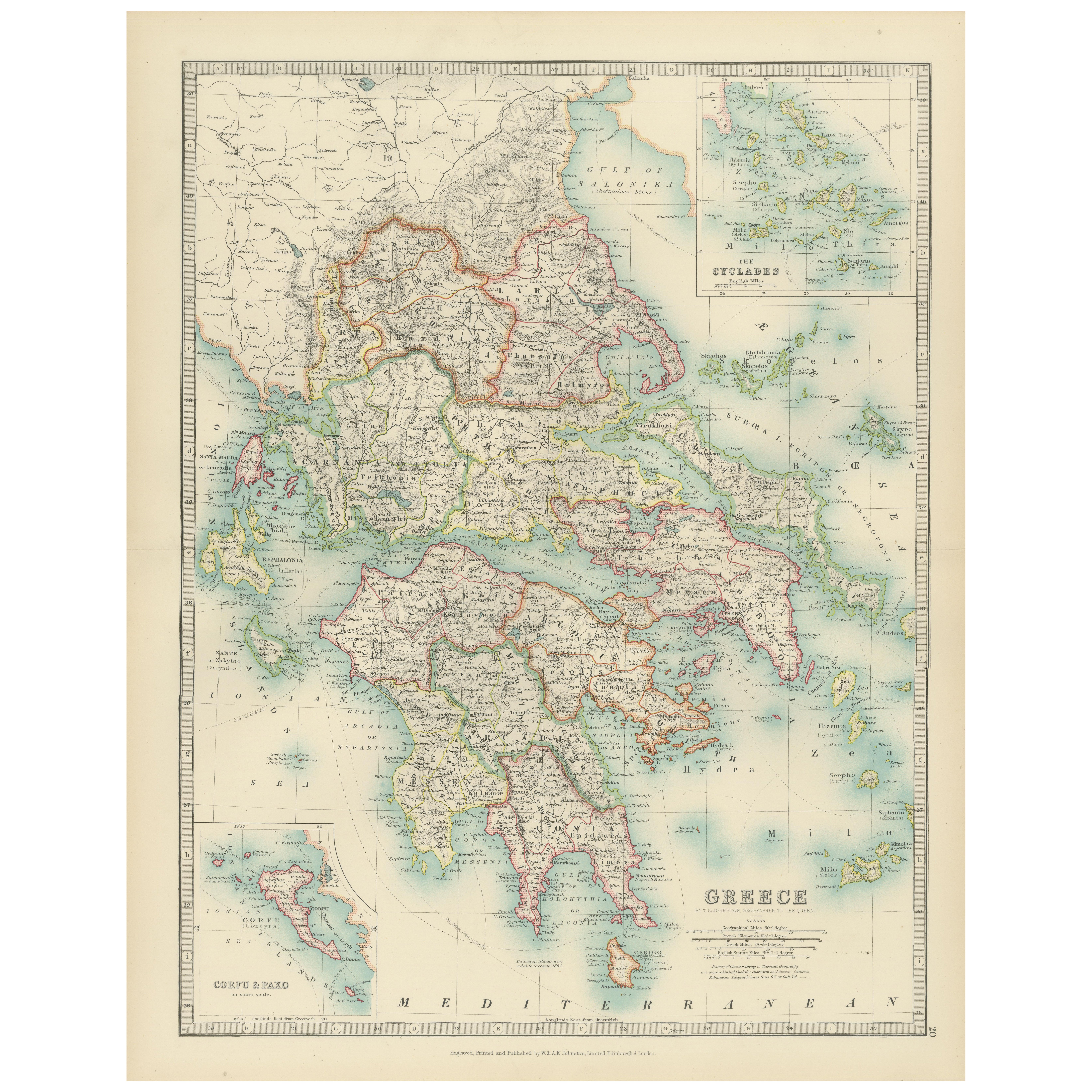
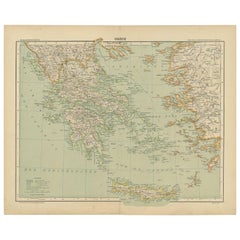
Antique Map of Greece & Crete – Johnston’s Eastern Question Map, 1887
**SEO Alternative Title**
Johnston Map of Greece & Crete 1887 – The Eastern Question Antique Map
This antique map, titled *“W. & A.K. Johnston’s Map of Greece, Crete etc. to Illustrate The Eastern Question”*, was published in 1887 in Edinburgh and London. It was designed to accompany contemporary debates over the so-called “Eastern Question” — the political and military rivalries surrounding the decline of the Ottoman Empire and the future of its territories in the Balkans and Eastern Mediterranean.
The main map shows Greece in detail, with its frontiers against the Ottoman Empire clearly marked. The Peloponnese, central Greece, Thessaly, Epirus, and the Aegean islands are finely engraved with towns, mountains, rivers, and coastal features. Particular emphasis is given to strategic locations such as Athens, Corinth, and the Gulf of Patras.
Inset maps in the right-hand panel provide additional context. These include:
* The wider Balkan region showing the Ottoman Empire, Bulgaria, and neighboring territories.
* A detailed map of Crete (labeled *Candia*), reflecting the island’s contested position in the 19th century.
* Insets of Corfu, Athens, and surrounding islands.
* A situational map of Europe to place the Eastern Mediterranean in its broader geopolitical frame.
Crete is shown in great detail, with mountain ranges, towns, ports, and fortifications carefully marked, underscoring its importance to both Greek national aspirations and Ottoman defense.
This map captures a key historical moment: the Greek state had recently expanded its frontiers, while tensions with the Ottoman Empire remained high. It was intended not just as a geographical tool but also as a political reference for readers of newspapers and journals following the shifting alliances in southeastern Europe.
Condition: Fair to Good. Original color printing with some age toning and foxing, particularly in the margins and folds. Paper remains strong, with old fold lines as issued but with a few small holes at the crossings. Ready to be framed.
Framing tips: A strong display piece for both collectors of Greek history and 19th-century political cartography. A dark wood or gilt frame with a cream mat would emphasize the map’s color washes and highlight the inset maps.
Technique: Lithograph with original color
Maker: W. & A.K. Johnston, Edinburgh & London, 1887
Collector’s note: W. & A.K. Johnston was one of the most respected Scottish publishing houses of the 19th century, producing atlases, school maps, and wall maps of high quality. Their maps dealing with contemporary political issues such as the “Eastern Question” were widely circulated and remain significant both as geographical documents and as reflections of European political anxieties in the late 19th century.*
- Dimensions:Height: 22.64 in (57.5 cm)Width: 34.97 in (88.8 cm)Depth: 0.01 in (0.2 mm)
- Materials and Techniques:
- Place of Origin:
- Period:
- Date of Manufacture:1897
- Condition:Condition: Fair to Good. Original color printing with some age toning and foxing, particularly in the margins and folds. Paper remains strong, with old fold lines as issued but with a few small holes at the crossings. Ready to be framed.
- Seller Location:Langweer, NL
- Reference Number:Seller: BG-13846-41stDibs: LU3054346392962
About the Seller
5.0
Recognized Seller
These prestigious sellers are industry leaders and represent the highest echelon for item quality and design.
Platinum Seller
Premium sellers with a 4.7+ rating and 24-hour response times
Established in 2009
1stDibs seller since 2017
2,589 sales on 1stDibs
Typical response time: <1 hour
- ShippingRetrieving quote...Shipping from: Langweer, Netherlands
- Return Policy
Authenticity Guarantee
In the unlikely event there’s an issue with an item’s authenticity, contact us within 1 year for a full refund. DetailsMoney-Back Guarantee
If your item is not as described, is damaged in transit, or does not arrive, contact us within 7 days for a full refund. Details24-Hour Cancellation
You have a 24-hour grace period in which to reconsider your purchase, with no questions asked.Vetted Professional Sellers
Our world-class sellers must adhere to strict standards for service and quality, maintaining the integrity of our listings.Price-Match Guarantee
If you find that a seller listed the same item for a lower price elsewhere, we’ll match it.Trusted Global Delivery
Our best-in-class carrier network provides specialized shipping options worldwide, including custom delivery.More From This Seller
View AllAntique Map of Greece and the Cyclades, 1903, with Many Details and Inset Maps
Located in Langweer, NL
Title: Antique Map of Greece and the Cyclades, 1903, with Intricate Detail and Inset Maps
Description: This antique map, titled "Greece with Its Islands, Including the Cyclades," wa...
Category
Early 20th Century Maps
Materials
Paper
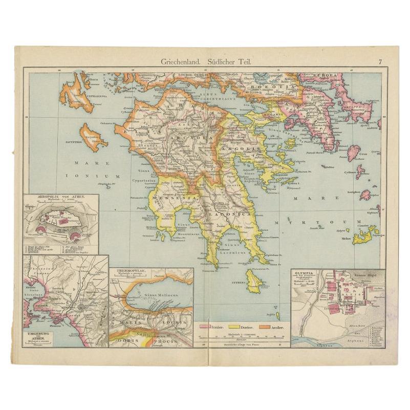
Antique Map of Southern Greece, 1892
Located in Langweer, NL
Antique map of Greece titled 'Griechenland. Südlicher Theil'. Old map of Southern Greece with inset maps of the Acropolis of Athens, the region of Athens, Thermopylae and Olympia. So...
Category
Antique 19th Century Maps
Materials
Paper

$80 Sale Price
20% Off
Original Antique Map of Greece and Epirus after the Persian Wars, Published 1880
Located in Langweer, NL
The map titled "GRAECIA, EPIRUS post bella Persica," translates to "Greece and Epirus after the Persian Wars." It covers the regions of ancient Greece and Epirus following the Greco-Persian Wars, a series of conflicts between the Greek city-states and the Persian Empire during the 5th century BC.
What makes this map interesting:
1. **Historical Context**: The period after the Persian Wars was pivotal for ancient Greece, leading to the rise of Athens as a major power and the Golden Age of Athens.
2. **Inset Maps**: Detailed insets, such as the one showing the Acropolis of Athens, provide close-up views of historically significant locations.
3. **Topography**: It features the diverse terrain of Greece, from the rugged mountain ranges to the intricate coastlines and islands, influencing the development of Greek city-states.
4. **City-States**: The map likely details the various polis or city-states, such as Athens, Sparta, Thebes, and others, which played critical roles in the Persian Wars.
5. **Battle Sites**: It might mark important battle sites from the wars, like Marathon, Thermopylae, Salamis, and Plataea.
6. **Latin Labels**: The use of Latin for place names and descriptions adds to the map's scholarly quality.
7. **Cultural Landmarks**: The map may include locations of significant cultural and historical landmarks from the era, such as temples, theatres, and agoras.
This map is from the "Spruner-Menke Atlas Antiquus," compiled by Karl Spruner von Merz and edited by Theodorus Menke. The atlas, known for its detailed maps of historical and ancient geographies, was a significant educational tool in the 19th century.
The Greco-Persian Wars, which included famous battles such as Marathon and Salamis, were crucial for the preservation of Greek independence...
Category
Antique 1880s Maps
Materials
Paper
$351 Sale Price
20% Off
Free Shipping
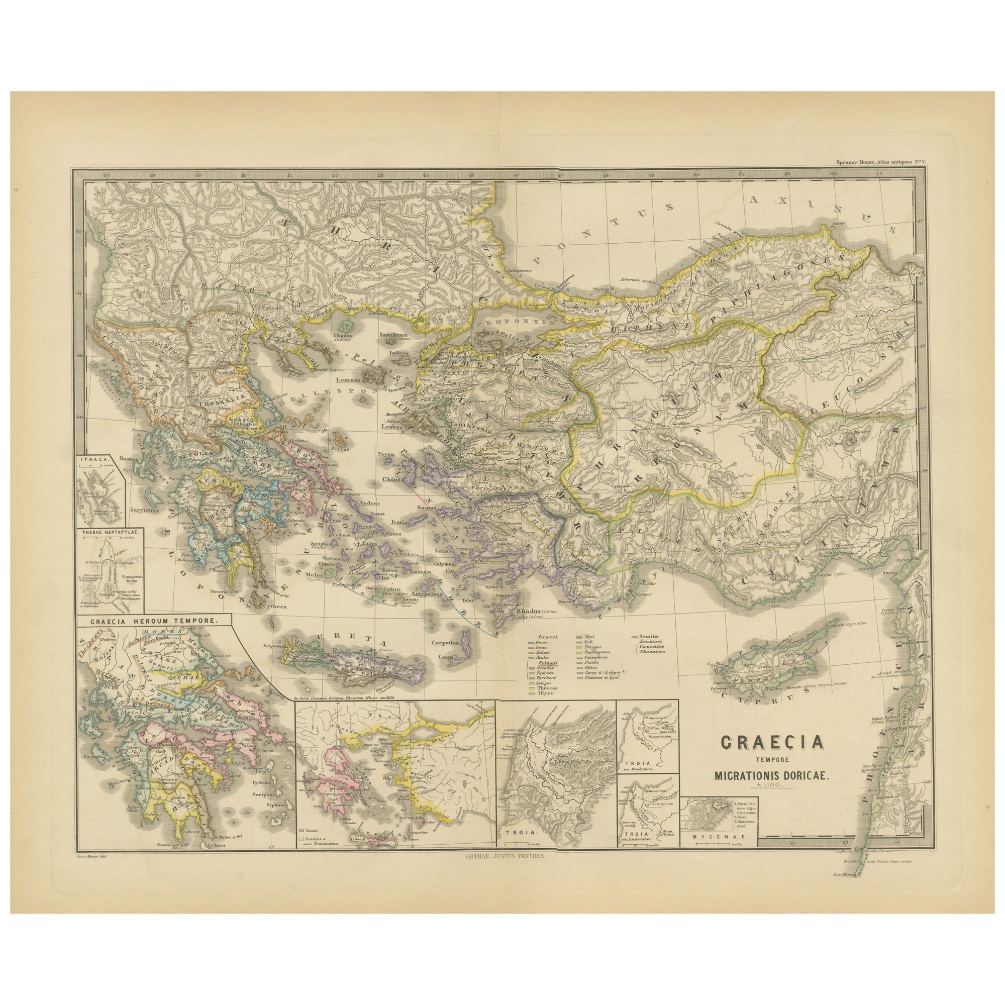
Original Map of Greece at the Time of the Dorian Migration, Published in 1880
Located in Langweer, NL
The map titled "GRAECIA TEMPORI MIGRATIONIS DORICAE," translates to "Greece at the Time of the Dorian Migration." This map showcases the regions of ancient Greece during the period f...
Category
Antique 1880s Maps
Materials
Paper
$351 Sale Price
20% Off
Free Shipping
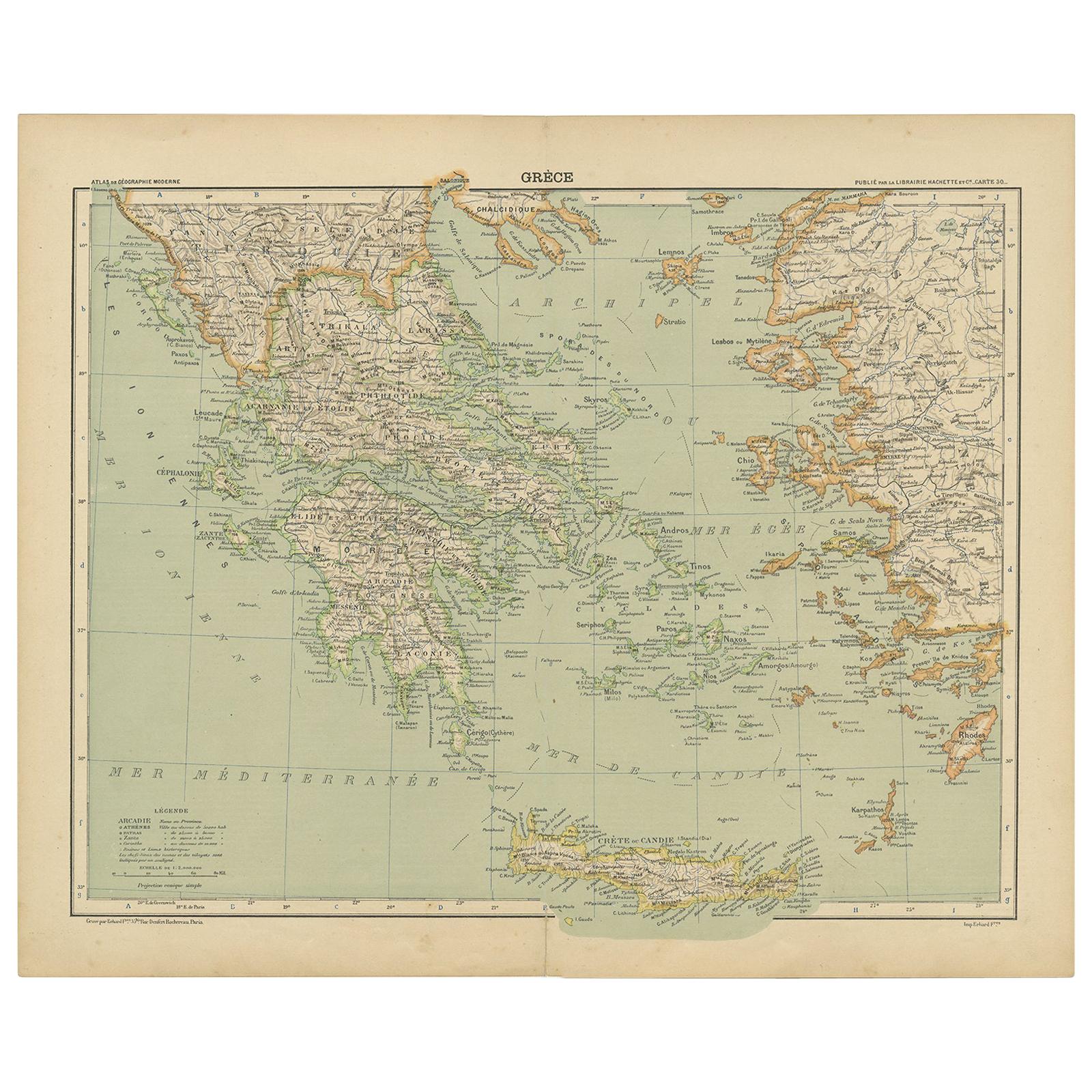
Antique Map of Greece and the Mediterranean by Hachette & Cie, '1896'
Located in Langweer, NL
Antique map of Greece titled 'Grèce'. Old map of Greece and other parts of the Mediterranean including Crete and the Ionian Islands. This map originates from 'Atlas de Géographie Mod...
Category
Antique Late 19th Century Prints
Materials
Paper
$142 Sale Price
20% Off
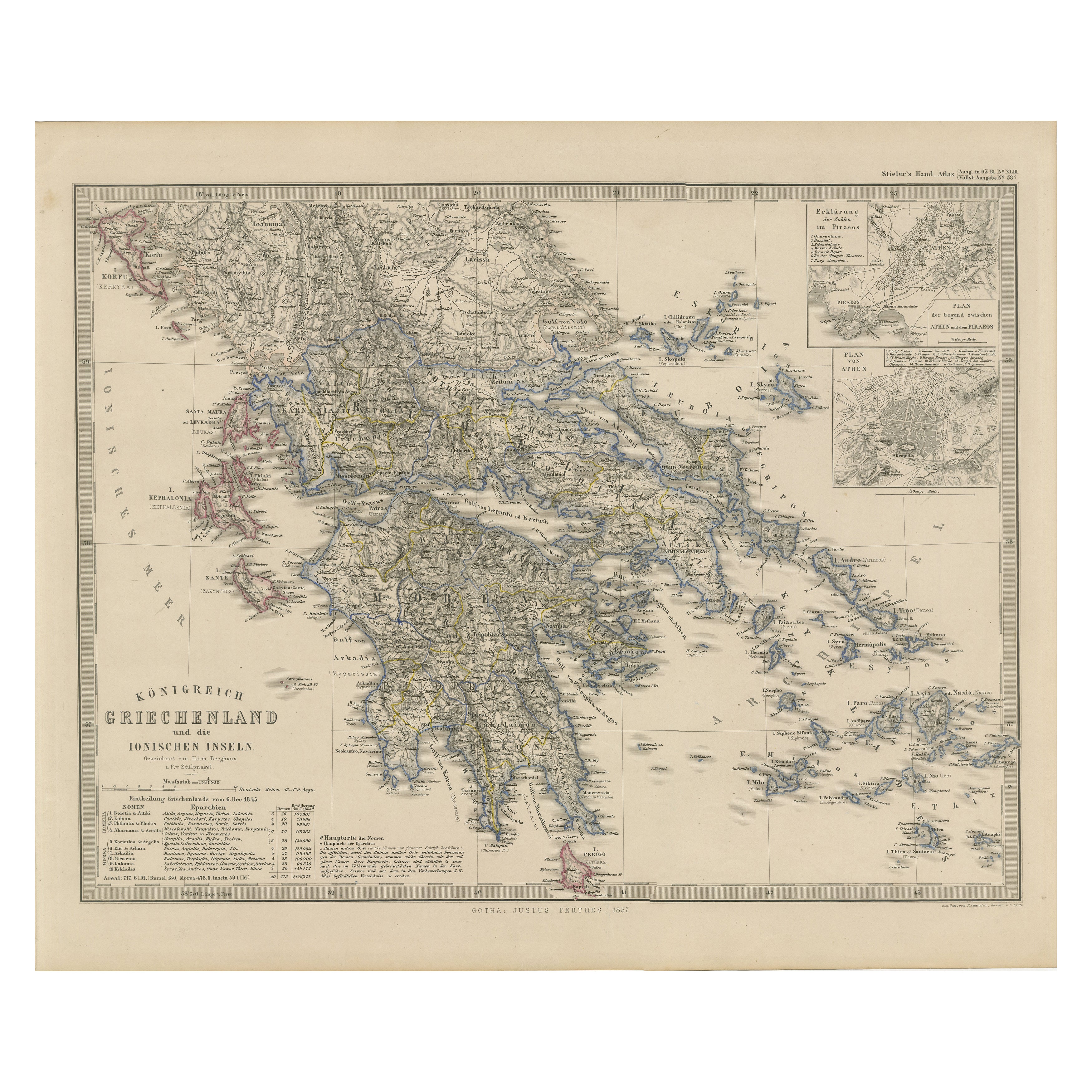
Greece Map – Kingdom of Greece and Ionian Islands 1847
Located in Langweer, NL
Greece Map – Kingdom of Greece and Ionian Islands 1847
This elegant antique print shows the Kingdom of Greece titled “Königreich Griechenland und die Ionischen Inseln” meaning “King...
Category
Antique Mid-19th Century German Maps
Materials
Paper
You May Also Like
Map of Greece - Etching on Paper 19th Century
Located in Roma, IT
Image dimensions: 22.2 x 27.8 cm.
Grecia is an interesting hand-colored etching on paper, realized by an anonymous artist in the first half of the XIX century.
With the inscriptions in Italian, this original print describes the geography of Greece with the great charisma of the antique maps.
In very good conditions, except for a usual yellowing of the paper at the edges and minor defects and signs of the time, and some light yellow strips...
Category
19th Century Modern Figurative Prints
Materials
Etching

Large Original Antique Map of Cyprus. 1894
Located in St Annes, Lancashire
Superb Antique map of Cyprus
Published Edward Stanford, Charing Cross, London 1894
Original colour
Good condition
Unframed.
Free shipping
Category
Antique 1890s English Maps
Materials
Paper

Large Original Antique Map of The Greek Islands. 1894
Located in St Annes, Lancashire
Superb Antique map of The Greek Islands
Published Edward Stanford, Charing Cross, London 1894
Original colour
Good condition
Unframed.
Free shipping
Category
Antique 1890s English Maps
Materials
Paper

Map of Ancient Greece of Macedonia and... - Lithograph by Auguste Wahlen - 1844
Located in Roma, IT
Map of Ancient Greece of Macedonia and Thrace is a lithograph made by Auguste Wahlen in 1844.
Hand colored.
Good condition.
Bottom left is the original title "Carta della Grecia A...
Category
1840s Modern Figurative Prints
Materials
Lithograph

Original Antique Map of Ancient Greece, Achaia, Corinth, 1786
Located in St Annes, Lancashire
Great map of Ancient Greece. Showing the region of Thessaly, including Mount Olympus
Drawn by J.D. Barbie Du Bocage
Copper plate engraving by P.F Tardieu
Original hand color...
Category
Antique 1780s French Other Maps
Materials
Paper

Map of Ancient Greece - Original Etching by Antonio Zatta - 1785
Located in Roma, IT
This Map of ancient Greek is an etching realized by Antonio Zatta in Venice in 1785.
The state of preservation of the artwork is good expect for the worn paper.
Mounted on a cardbo...
Category
1770s Landscape Prints
Materials
Etching
