Items Similar to Large Antique Map of Java & Madura with Batavia Inset, c.1870s Dutch East Indies


Want more images or videos?
Request additional images or videos from the seller
1 of 15
Large Antique Map of Java & Madura with Batavia Inset, c.1870s Dutch East Indies
$1,660.10
£1,233.59
€1,400
CA$2,297.68
A$2,558.65
CHF 1,335.93
MX$31,002.74
NOK 16,847.46
SEK 15,896.90
DKK 10,659.85
About the Item
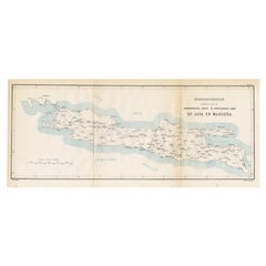
Large Antique Map of Java & Madura with Batavia Inset, c.1870s Dutch East Indies
This finely detailed 19th-century Dutch colonial map is titled “Java en Madoera op den schaal van 1:600.000”, published in Amsterdam by Seyffardt’s Boekhandel in the late 19th century, circa 1870s–1880s. The map was produced at a scale of 1:600,000, offering an authoritative overview of the most important island of the Netherlands Indies.
The map covers the entire island of Java together with Madura, highlighting towns, residencies, mountain ranges, rivers, and the road network. Relief is expressed through finely engraved hachures, and administrative divisions are outlined with subtle original hand color.
In the lower left corner, an important inset plan shows Batavia (modern Jakarta) and its port area, with canals, fortifications, and public buildings carefully named — a rare and valuable reference to the colonial capital during its 19th-century expansion.
Size: approx. 124 × 42 cm (49 × 16½ in) when fully opened. Dissected into panels and mounted on original linen, as issued, making it both portable and durable.
Condition: Good. Original linen backing with issued folds. Some light toning and minor spotting along folds and intersections, but overall strong and complete.
Framing Tips: Due to its long horizontal format, this map works best in a wide landscape-style frame. A black or dark wood frame with a cream or pale grey mat highlights the detail while emphasizing its cartographic presence.
Technique: Engraving with original hand color, dissected and mounted on linen
Maker: Seyffardt’s Boekhandel, Amsterdam, c.1870s
---
Collector’s Note: Large-scale Dutch colonial maps of Java were indispensable for administrators, traders, and travelers. Seyffardt’s edition is especially desirable for its Batavia inset, documenting the colonial capital in fine detail. Surviving examples in good condition are increasingly scarce and sought after by collectors of Indonesia and the Dutch East Indies.
- Dimensions:Height: 16.54 in (42 cm)Width: 48.82 in (124 cm)Depth: 0.08 in (2 mm)
- Materials and Techniques:
- Place of Origin:
- Period:
- Date of Manufacture:circa 1870
- Condition:Condition: Good. Original linen backing with issued folds. Some light toning and minor spotting along folds and intersections, but overall strong and complete.
- Seller Location:Langweer, NL
- Reference Number:Seller: BG-140751stDibs: LU3054346393712
About the Seller
5.0
Recognized Seller
These prestigious sellers are industry leaders and represent the highest echelon for item quality and design.
Platinum Seller
Premium sellers with a 4.7+ rating and 24-hour response times
Established in 2009
1stDibs seller since 2017
2,589 sales on 1stDibs
Typical response time: <1 hour
- ShippingRetrieving quote...Shipping from: Langweer, Netherlands
- Return Policy
Authenticity Guarantee
In the unlikely event there’s an issue with an item’s authenticity, contact us within 1 year for a full refund. DetailsMoney-Back Guarantee
If your item is not as described, is damaged in transit, or does not arrive, contact us within 7 days for a full refund. Details24-Hour Cancellation
You have a 24-hour grace period in which to reconsider your purchase, with no questions asked.Vetted Professional Sellers
Our world-class sellers must adhere to strict standards for service and quality, maintaining the integrity of our listings.Price-Match Guarantee
If you find that a seller listed the same item for a lower price elsewhere, we’ll match it.Trusted Global Delivery
Our best-in-class carrier network provides specialized shipping options worldwide, including custom delivery.More From This Seller
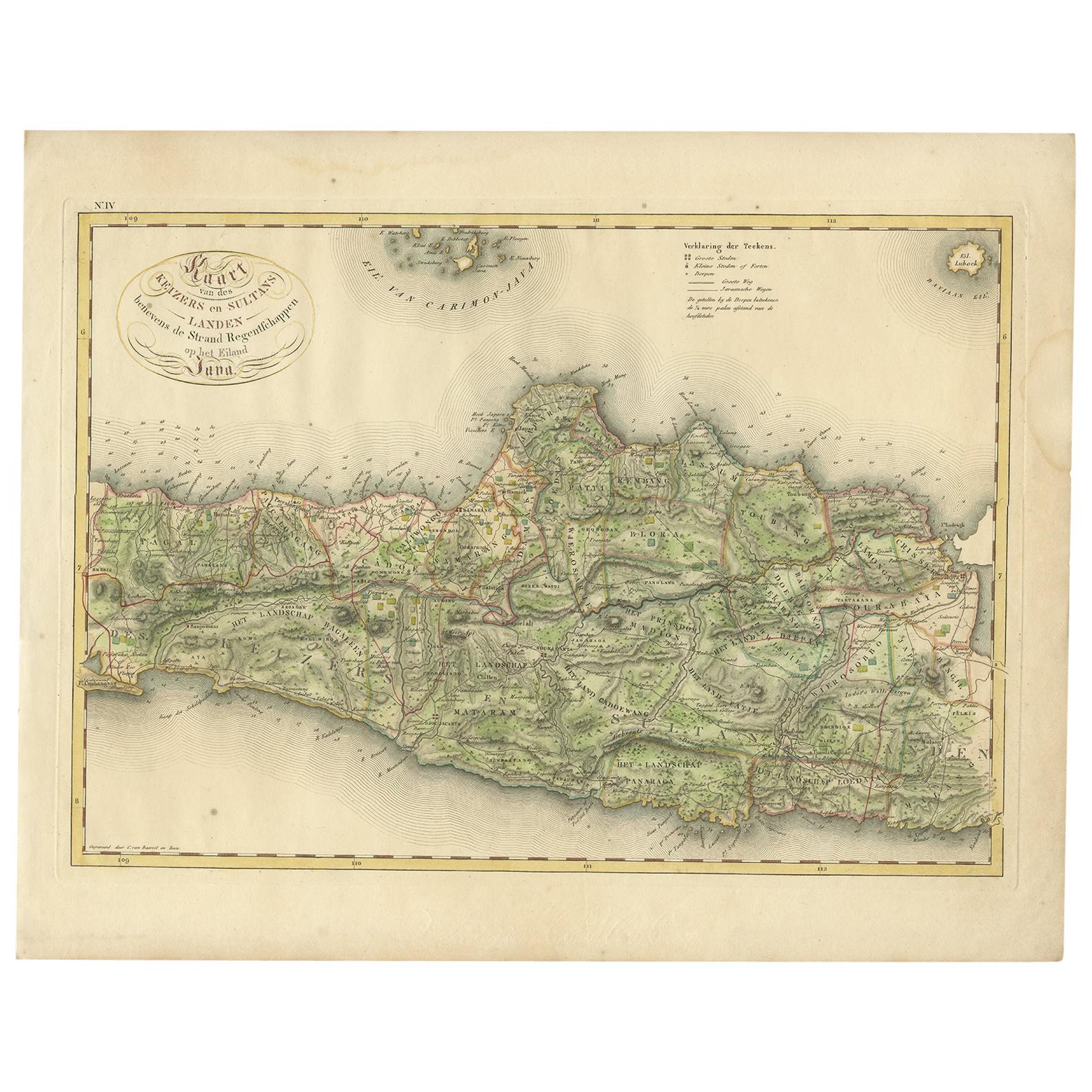
View AllAntique Map of Central and East Java by Van den Bosch, 1818
Located in Langweer, NL
Antique map titled 'Kaart van de Keizers en Sultans Landen benevens de Strand Regentschappen op het Eiland Java'. Map of three central and easterly provinces of the island of Java. O...
Category
Antique Early 19th Century Maps
Materials
Paper

$1,138 Sale Price
20% Off
Antique Map of the East Indies by Van der Aa '1849'
Located in Langweer, NL
Antique map titled 'Kaart van Nederlands OostIndie door A.J. van der Aa'. Old map of the Dutch East Indies. This map originates from 'Nederlands Oost-Indië, of beschrijving der Neder...
Category
Antique Mid-19th Century Maps
Materials
Paper

$379 Sale Price
20% Off
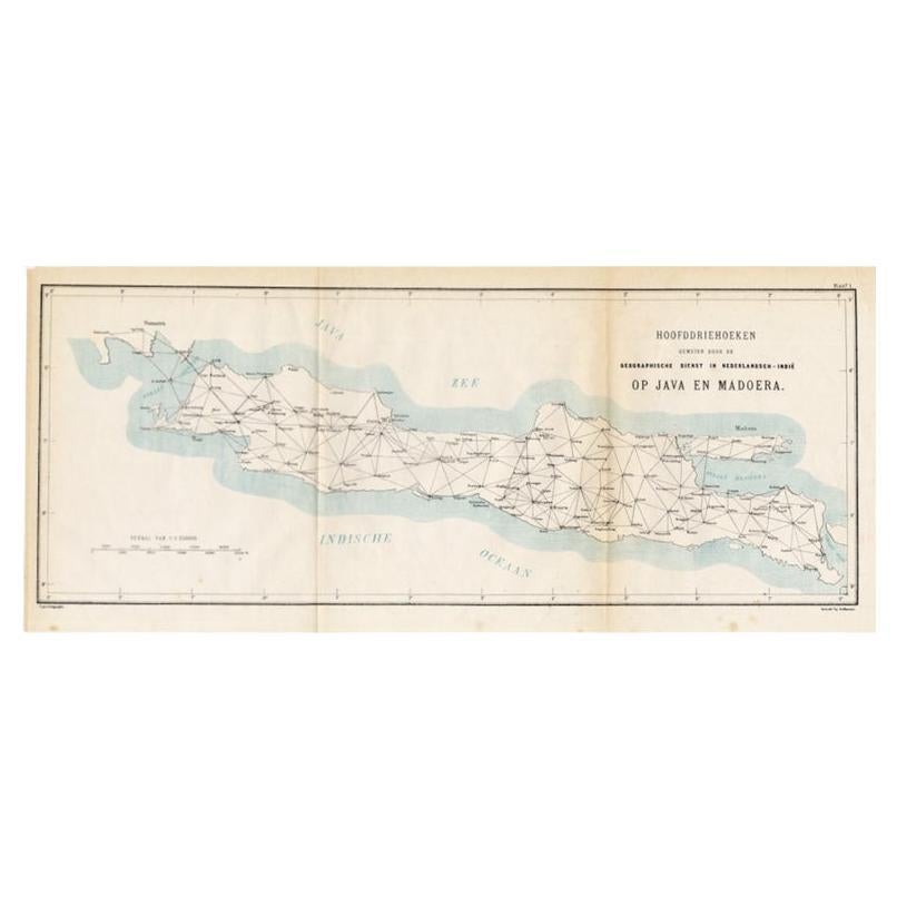
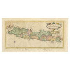
Old Map of Java, Indonesia by Stemler, 1875
By Stemler
Located in Langweer, NL
Antique map titled 'Hoofddriehoeken - Java en madoera.' (Main triangles measured by the Geographical Service in the Dutch-Indies on Java and Madoera.) This scarce map shows the Indon...
Category
Antique 19th Century Maps
Materials
Paper
$66 Sale Price
20% Off
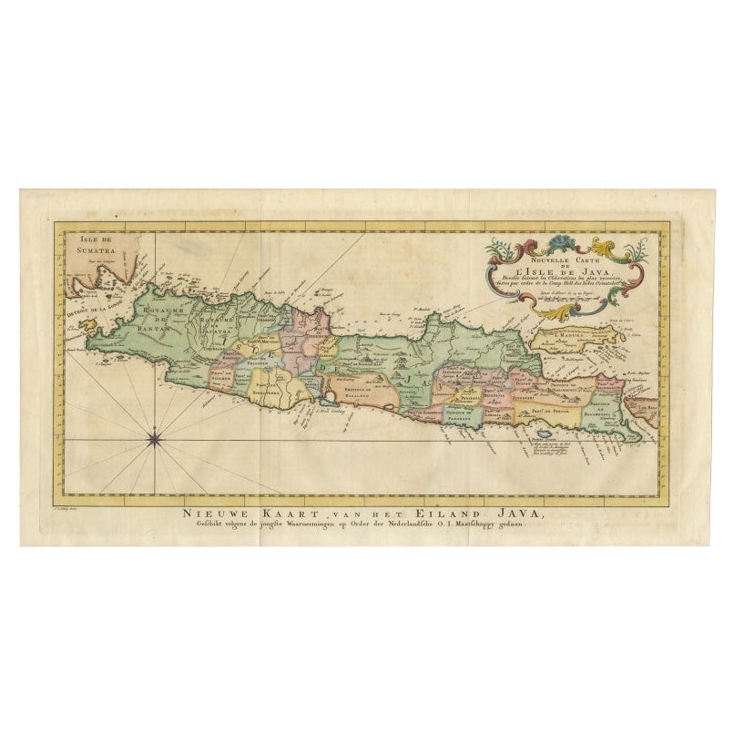
Antique Map of Java, Madura, Bali and the Sunda Strait, Indonesia, c.1770
Located in Langweer, NL
Antique map Indonesia titled 'Nouvelle Carte de l'Isle de Java - Nieuwe kaart, van het Eiland Java'. Chart of the island of Java, depicting soun...
Category
Antique 18th Century Maps
Materials
Paper
$426 Sale Price
20% Off
Antique Map of the Region of Lampung, Sumatra, Indonesia, 1900
Located in Langweer, NL
Antique map of the region of Lampung, Sumatra. Also depicting part of Palembang and Java. This map originates from 'Atlas van Nederlandsch Oost- en West-Indië' by I. Dornseiffen.
A...
Category
20th Century Maps
Materials
Paper

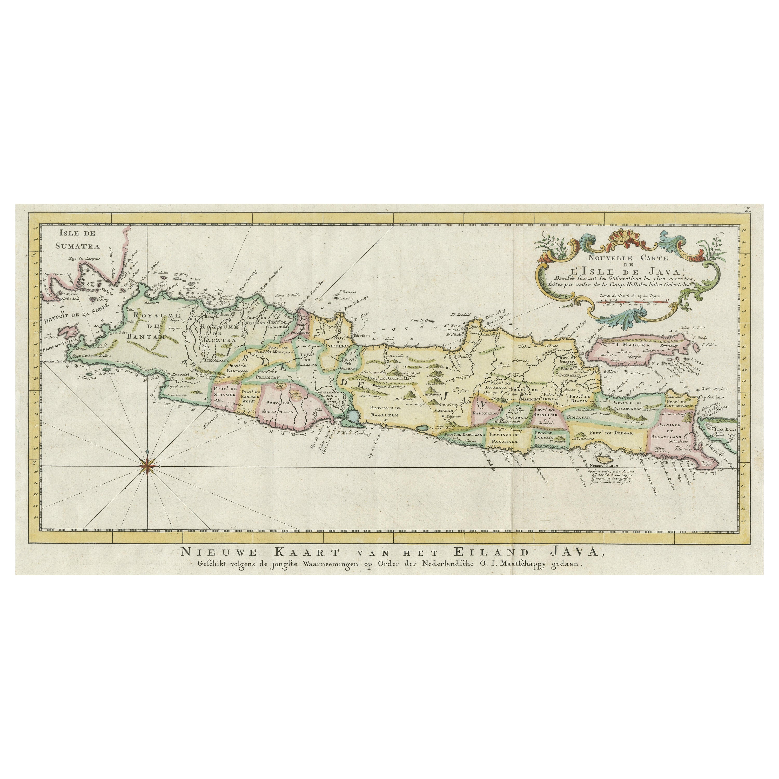
Antique Map of the Island of Java, Indonesia
Located in Langweer, NL
Antique map titled 'Nouvelle Carte de l'Isle de Java (..) - Nieuwe Kaart van het Eiland Java (..)'. Chart of the island of Java, depicting soundings around the coast, all principal h...
Category
Antique Late 18th Century Maps
Materials
Paper

$426 Sale Price
20% Off
You May Also Like
Large Original Antique Map of Java and Borneo, Fullarton, C.1870
Located in St Annes, Lancashire
Great map of Java and Borneo
Wonderful figurative borders
From the celebrated Royal Illustrated Atlas
Lithograph. Original color.
Published by Fullarton, Edinburgh. C.1870
Unfr...
Category
Antique 1870s Scottish Maps
Materials
Paper

Central America. Century Atlas antique vintage map
Located in Melbourne, Victoria
'The Century Atlas. Central America.'
Original antique map, 1903.
Inset maps of 'The Country around Lake Nicaragua'.
Central fold as issued. Map name and number printed on the reve...
Category
Early 20th Century Victorian More Prints
Materials
Lithograph

Antique 1803 Italian Map of Asia Including China Indoneseia India
Located in Amsterdam, Noord Holland
Antique 1803 Italian Map of Asia Including China Indoneseia India
Very nice map of Asia. 1803.
Additional information:
Type: Map
Country of Manufacturing: Europe
Period: 19th centu...
Category
Antique 19th Century European Maps
Materials
Paper

$584 Sale Price
20% Off
Map of the East Indies: An Original 18th Century Hand-colored Map by E. Bowen
Located in Alamo, CA
This is an original 18th century hand-colored map entitled "An Accurate Map of the East Indies Exhibiting the Course of the European Trade both on the Continent and Islands" by Emanu...
Category
Mid-18th Century Old Masters Landscape Prints
Materials
Engraving

Africa. North-West Part. Century Atlas antique vintage map
Located in Melbourne, Victoria
'The Century Atlas. Africa. Southern Part'
Original antique map, 1903.
Central fold as issued. Map name and number printed on the reverse corners.
Sheet 40cm by 29.5cm.
Category
Early 20th Century Victorian More Prints
Materials
Lithograph

Original Antique Map of South East Asia by Thomas Clerk, 1817
Located in St Annes, Lancashire
Great map of South East Asia
Copper-plate engraving
Drawn and engraved by Thomas Clerk, Edinburgh.
Published by Mackenzie And Dent, 1817
Unframed.
Category
Antique 1810s English Maps
Materials
Paper
