Items Similar to Old Map of Java, Indonesia by Stemler, 1875

Want more images or videos?
Request additional images or videos from the seller
Old Map of Java, Indonesia by Stemler, 1875
About the Item
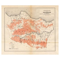
Antique map titled 'Hoofddriehoeken - Java en madoera.' (Main triangles measured by the Geographical Service in the Dutch-Indies on Java and Madoera.) This scarce map shows the Indonesian island of Java. With scale. Originates from 'Tijdschrift Aardrijkskundig Genootschap', published by C. F. Stemler in Amsterdam, ca. 1875.
Artists and Engravers: Lithographed by Hoffmeister.
Condition: Good, general age related toning; some light staining from handling. Please study image carefully.
Date: c.1875
Overall size: 59 x 27.5 cm.
Image size: 0.001 x 56 x 21.5 cm.
We sell original antique maps to collectors, historians, educators and interior decorators all over the world. Our collection includes a wide range of authentic antique maps from the 16th to the 20th centuries. Buying and collecting antique maps is a tradition that goes back hundreds of years. Antique maps have proved a richly rewarding investment over the past decade, thanks to a growing appreciation of their unique historical appeal. Today the decorative qualities of antique maps are widely recognized by interior designers who appreciate their beauty and design flexibility. Depending on the individual map, presentation, and context, a rare or antique map can be modern, traditional, abstract, figurative, serious or whimsical. We offer a wide range of authentic antique maps for any budget.
- Creator:Stemler (Artist)
- Dimensions:Height: 10.83 in (27.5 cm)Width: 23.23 in (59 cm)Depth: 0 in (0.01 mm)
- Materials and Techniques:
- Period:
- Date of Manufacture:circa 1875
- Condition:
- Seller Location:Langweer, NL
- Reference Number:
About the Seller
5.0
Platinum Seller
These expertly vetted sellers are 1stDibs' most experienced sellers and are rated highest by our customers.
Established in 2009
1stDibs seller since 2017
1,949 sales on 1stDibs
Typical response time: <1 hour
- ShippingRetrieving quote...Ships From: Langweer, Netherlands
- Return PolicyA return for this item may be initiated within 14 days of delivery.
More From This SellerView All
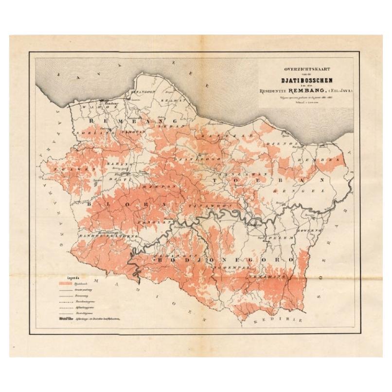
- Antique Map of the Djati 'teak wood' Forest Near Rembang, Java by Stemler, 1875By StemlerLocated in Langweer, NLAntique map titled 'Overzichtskaart van de Djatibosschen in de Residentie Rembang, Java.' This scarce map shows the Djati (teak) Forest on the indonesian island of Java. Originates f...Category
Antique 19th Century Maps
MaterialsPaper
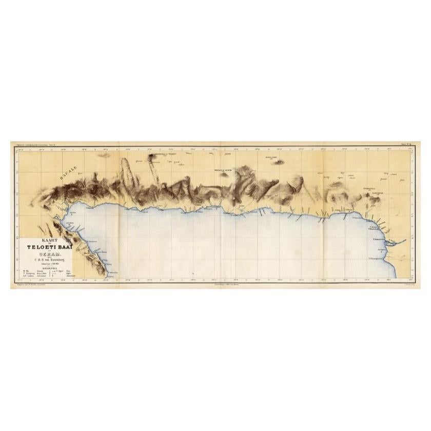
- Antique Map of Taluti Bay by Stemler, C.1875Located in Langweer, NLAntique map titled 'Kaart der Teloeti Baai op Ceram.' This scarce map shows the Taluti Bay on the Moluccan island of Ceram. Originates from 'Tijdschrift Aardrijkskundig Genootschap',...Category
Antique 19th Century Maps
MaterialsPaper
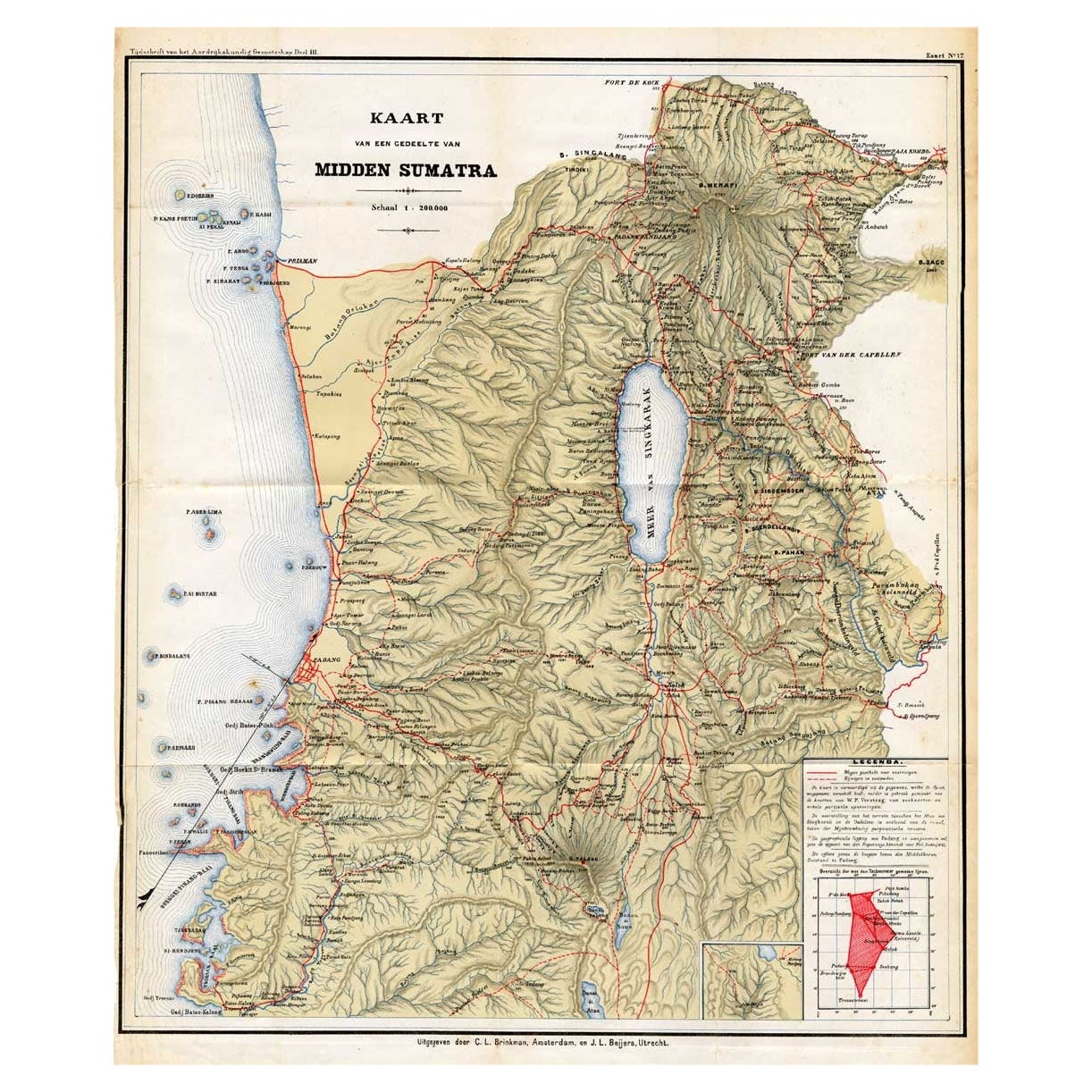
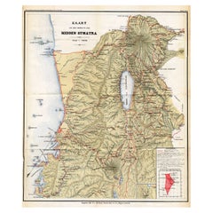
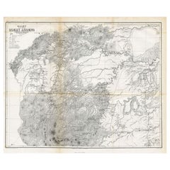
- Antique Map of Part of Sumatra by Stemler, c.1875Located in Langweer, NLAntique map titled 'Kaart van een gedeelte van Midden Sumatra.' This map shows a part of the Indonesian island of Sumatra. With legend. Originates from 'Tijdschrift Aardrijkskundig G...Category
Antique 19th Century Maps
MaterialsPaper
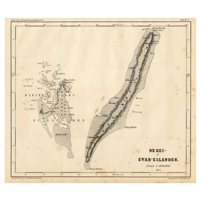
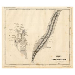
- Antique Map of the Kai Islands by Stemler, c.1875Located in Langweer, NLAntique map titled 'De Kei- of Evar eilanden.' (Kai Islands.) This map shows the Indonesian Kai Islands. Originates from 'Tijdschrift Aardrijkskundig Genootschap', published by C. F....Category
Antique 19th Century Maps
MaterialsPaper
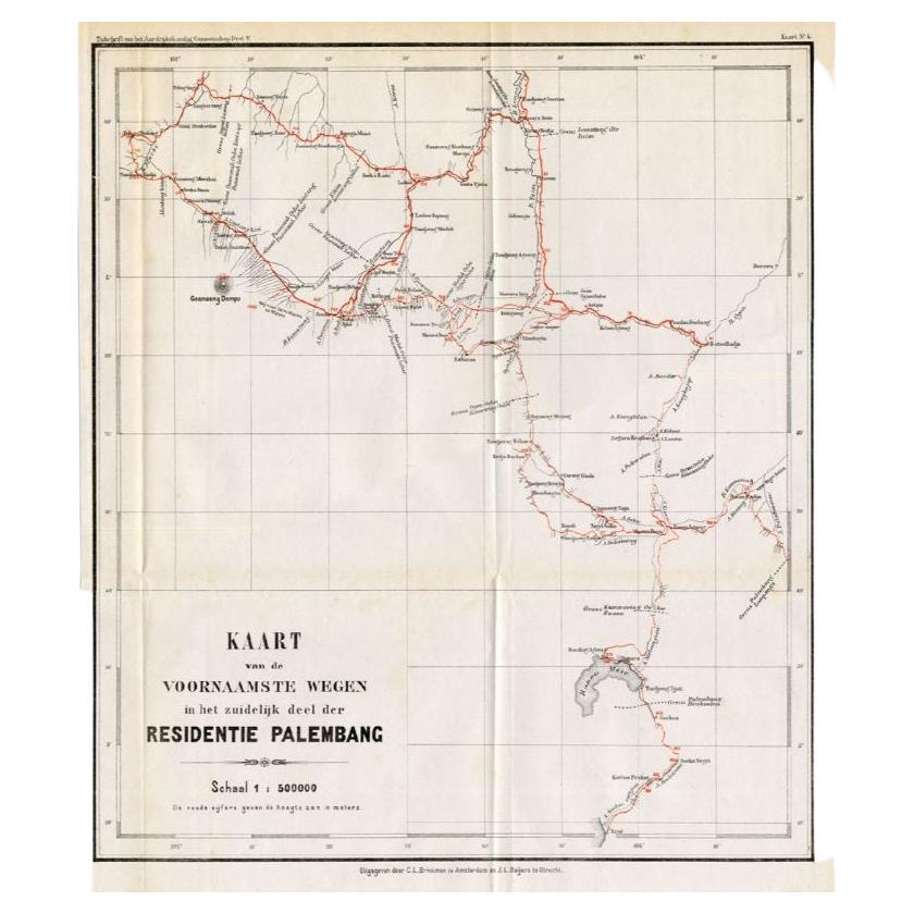
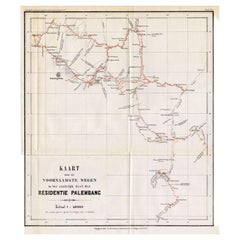
- Antique Map of the Main Roads of Palembang by Stemler, c.1875Located in Langweer, NLAntique map titled 'Kaart van de voornaamste wegen in het zuidelijke deel der Residentie Palembang.' This scarce map shows the main roads in Palembang on the Indonesian island of Sum...Category
Antique 19th Century Maps
MaterialsPaper
- Antique Map of the District of Boemi Agoeng by Stemler, c.1875Located in Langweer, NLAntique map titled 'Kaart van de Afdeling Boemi Agoeng.' This map shows the Indonesian district of Boemi Agoeng (Lampong districts). Originates from 'Tijdschrift Aardrijkskundig Geno...Category
Antique 19th Century Maps
MaterialsPaper

You May Also Like
- 1875 "North America" Map by J. BartholomewLocated in Colorado Springs, COPresented is an original 1875 map of “North America.” The map was issued in Volume 1 of the Ninth Edition of the Encyclopædia Britannica, published in Edinburgh. The map was drawn by famous Scottish mapmaker John Bartholomew. The map depicts North America, to include Greenland, the Dominion of Canada, the United States, Mexico, the countries of Central America, and the islands of the West Indies. Prominent rivers, mountain ranges, and cities are labeled on the map, and country borders are emphasized in red. The Encyclopædia Britannica has been published continuously since 1768, appearing in fifteen official editions. The landmark ninth edition of the Encyclopædia Britannica, often called "the Scholar's Edition," was published from January 1875 to 1889 in 25 volumes. The editor and author of the “Foreword” was Thomas Spencer Baynes, the first English-born editor after a series of Scots. After 1880, Baynes was assisted by William Robertson Smith. The 9th edition is often lauded as a high point among early editions for scholarship. The 9th edition was far more luxurious than any previously printed Encyclopædia Britannicas, with thick boards and quality leather bindings, premier paper, and a production which took full advantage of the technological advances of printing in the years between the 1850s and 1870s. The publishers took advantage of the new ability to print large graphic illustrations on the same pages as the text, as opposed to limiting illustrations to separate copper plate engravings. Although this technology had first been used in a primitive fashion the 7th edition, and to a much lesser extent in the 8th, in the 9th edition there were thousands of quality illustrations and maps set...Category
Antique 1870s Scottish Maps
MaterialsPaper
- Original Antique Map of Indonesia, 1861Located in St Annes, LancashireGreat map of Indonesia Drawn and engraved by Edward Weller Original color Published in The Weekly Dispatch Atlas, 1861 Repairs to minor e...Category
Antique 1860s English Victorian Maps
MaterialsPaper

- Old Nautical Map of CorsicaLocated in Alessandria, PiemonteST/556/1 - Old map of Corsica isle, surveyed by Captain Hell, of the French Royal Navy in 1824, engraved and published on 1874, with additions and corre...Category
Antique Early 19th Century English Other Prints
MaterialsPaper
- Old Horizontal Map of EnglandBy TassoLocated in Alessandria, PiemonteST/520 - Old rare Italian map of England, dated 1826-1827 - by Girolamo Tasso, editor in Venise, for the atlas of M.r Le-Sage.Category
Antique Early 19th Century Italian Other Prints
MaterialsPaper
- Large Original Antique Map of Java and Borneo, Fullarton, C.1870Located in St Annes, LancashireGreat map of Java and Borneo Wonderful figurative borders From the celebrated Royal Illustrated Atlas Lithograph. Original color. Published by Fullarton, Edinburgh. C.1870 Unfr...Category
Antique 1870s Scottish Maps
MaterialsPaper
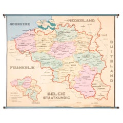
- XL Old School Map of Belgium 'Printed by Procure', 1950sLocated in Oostende, BEXL Old school map of Belgium (Printed by Procure). Presumably from around 1950-1960.Category
Vintage 1950s Belgian Mid-Century Modern Maps
MaterialsMetal


Recently Viewed
View AllMore Ways To Browse
Old Scales Antique
Old Antique Scale
Old Antique Scales Scales
Old Antique Scales
Map Light
Scale Map
Java Indonesia
Triangle Handle
Antique Maps Amsterdam
Amsterdam Map
Map Of Amsterdam
Antique Old World Map
Old World Antique Map
Old Antique World Map
Old World Antique Maps
Antique Old Map Of The World
Antique Java
Java Antique Furniture