Items Similar to Map of Choromandel & Malabar, Incl Kerala, Tamil Nadu & Part of Sri Lanka, 1726

Want more images or videos?
Request additional images or videos from the seller
1 of 10
Map of Choromandel & Malabar, Incl Kerala, Tamil Nadu & Part of Sri Lanka, 1726
$587.39
$1,174.7850% Off
£436.35
£872.6950% Off
€490
€98050% Off
CA$815.66
CA$1,631.3150% Off
A$890.07
A$1,780.1450% Off
CHF 466.86
CHF 933.7150% Off
MX$10,810.19
MX$21,620.3850% Off
NOK 5,831.29
NOK 11,662.5850% Off
SEK 5,510.86
SEK 11,021.7250% Off
DKK 3,730.32
DKK 7,460.6450% Off
About the Item
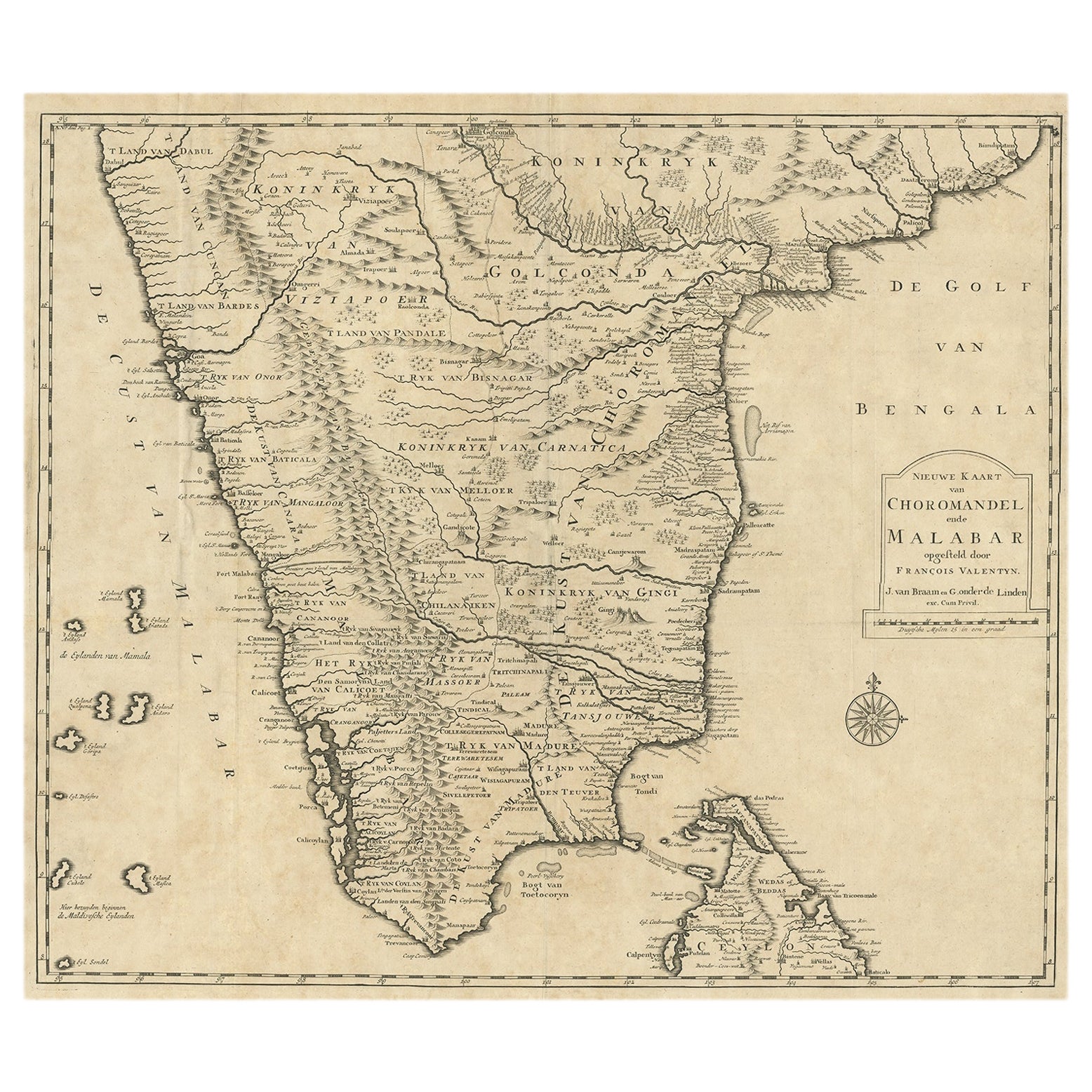
Antique map titled 'Nieuwe kaart van Choromandel ende Malabar.'
Original antique map of Southern India documenting the VOC's areas of influence. Included is Kerala, Tamil Nadu and the northern edge of Sri Lanka. This map originates from 'Oud en Nieuw Oost-Indiën (..)' by François Valentyn / Valentijn, published in 1724-1726.
Artists and Engravers: The author François Valentijn (1666-1727), was a Dutch missionary, worked at Amboina from 1684 to 1694 and 1705 to 1713 and traveled extensively in the VOC's lands.
- Dimensions:Height: 21.66 in (55 cm)Width: 24.81 in (63 cm)Depth: 0.01 in (0.2 mm)
- Materials and Techniques:Paper,Engraved
- Place of Origin:
- Period:1720-1729
- Date of Manufacture:1726
- Condition:Repaired: One tear in a fold, with old restoration. Condition: Good, given age. Original folds as issued. General age-related toning and/or occasional minor defects from handling. Please study image carefully.
- Seller Location:Langweer, NL
- Reference Number:Seller: PCT-51158 1stDibs: LU3054327343892
About the Seller
5.0
Recognized Seller
These prestigious sellers are industry leaders and represent the highest echelon for item quality and design.
Platinum Seller
Premium sellers with a 4.7+ rating and 24-hour response times
Established in 2009
1stDibs seller since 2017
2,641 sales on 1stDibs
Typical response time: <1 hour
- ShippingRetrieving quote...Shipping from: Langweer, Netherlands
- Return Policy
Authenticity Guarantee
In the unlikely event there’s an issue with an item’s authenticity, contact us within 1 year for a full refund. DetailsMoney-Back Guarantee
If your item is not as described, is damaged in transit, or does not arrive, contact us within 7 days for a full refund. Details24-Hour Cancellation
You have a 24-hour grace period in which to reconsider your purchase, with no questions asked.Vetted Professional Sellers
Our world-class sellers must adhere to strict standards for service and quality, maintaining the integrity of our listings.Price-Match Guarantee
If you find that a seller listed the same item for a lower price elsewhere, we’ll match it.Trusted Global Delivery
Our best-in-class carrier network provides specialized shipping options worldwide, including custom delivery.More From This Seller
View AllOld Original Map of Chormandel & Malabar, India & Ceylon, Now Sri Lanka, 1726
Located in Langweer, NL
Antique map titled 'Nieuwe Kaart van Choromandel ende Malabar'.
Antique map depicting the southern part of India and the northern tip of Ceylon, Sri Lanka. This map originates from...
Category
Antique 1720s Maps
Materials
Paper
$527 Sale Price
20% Off
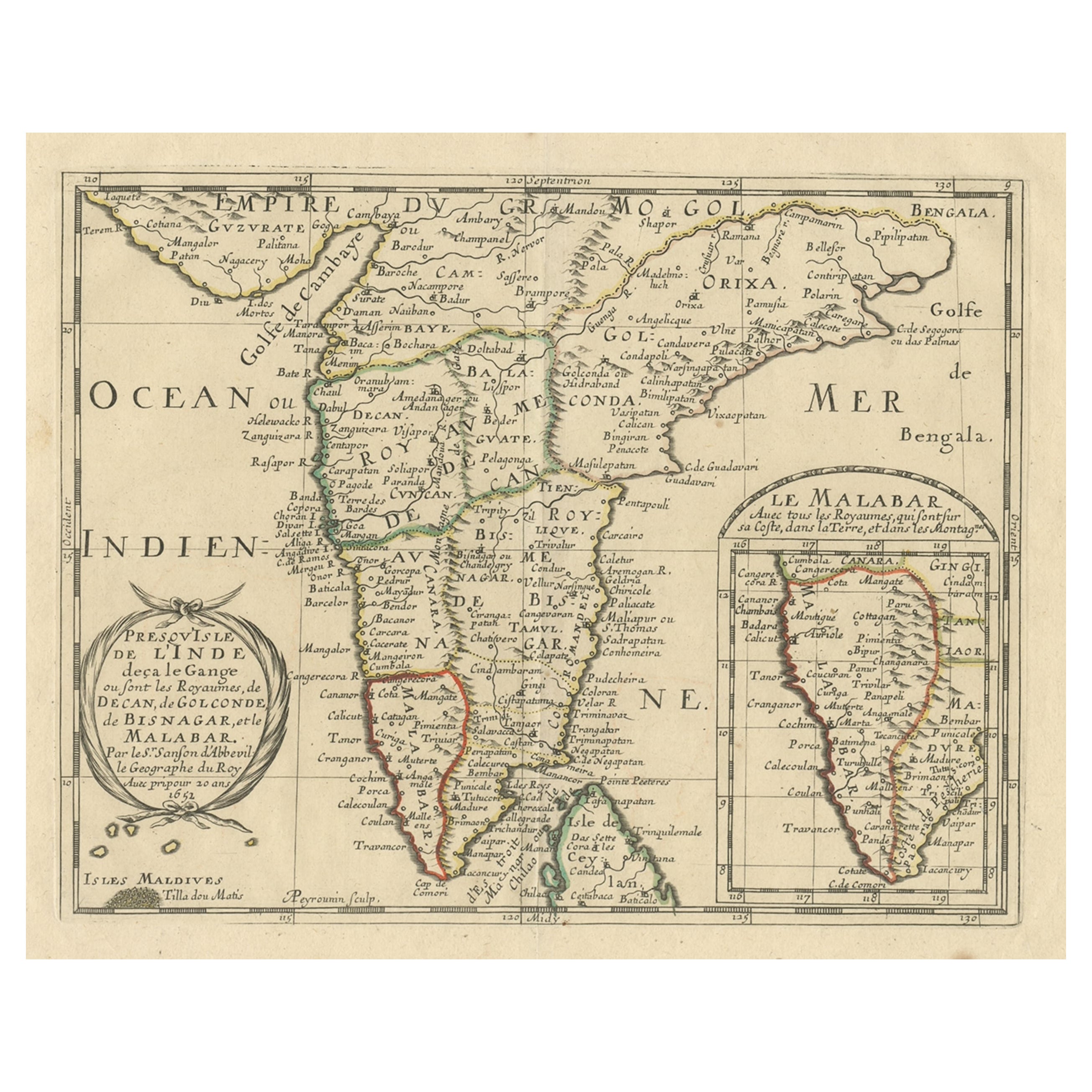
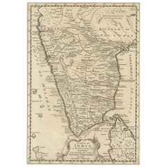
Original Antique Map showing Southern India, Northern Sri Lanka & Malabar, 1652
Located in Langweer, NL
Antique map titled 'Presqu'Isle de l'Inde deca le Gange (..)'.
Old map showing the southern part of India, including the northern part of Sri Lanka. With inset map of Southern India (Malabar). This map covers the subcontinent from the Bay of Bengal and the Gulf of Cambay to Ceylon. The Mogul Empire can be found in the north. Further south...
Category
Antique 1650s Maps
Materials
Paper

$632 Sale Price
20% Off
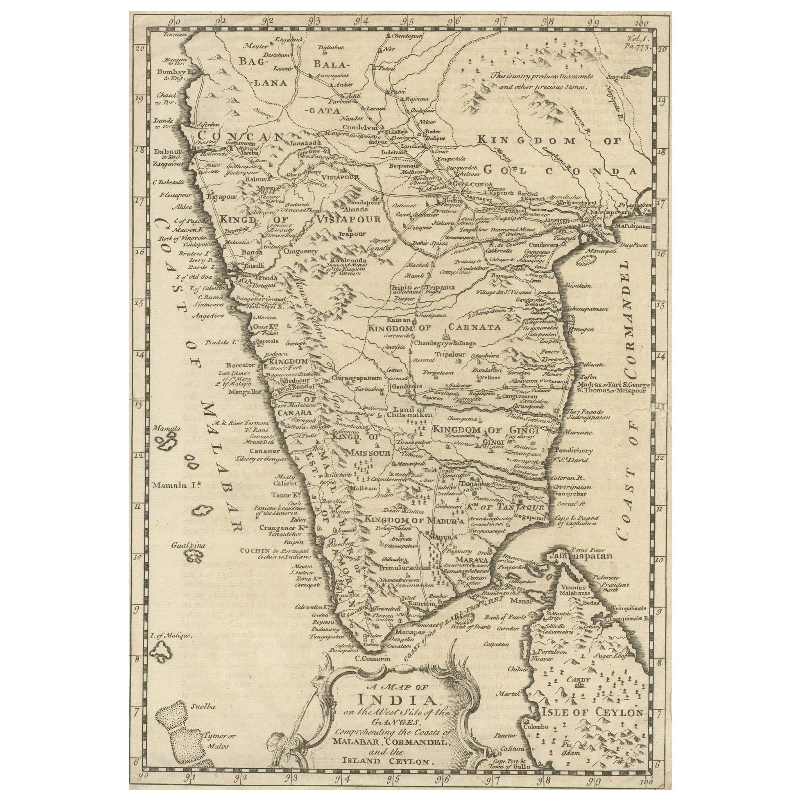
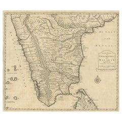
Original Detailed Antique Map of Southern India and Most of Ceylon, 1744
Located in Langweer, NL
Antique map titled 'A Map of India on the west Side of the Ganges, comprehending the coasts of Malabar, Coromandel and the Island Ceylon'.
Map of Southern India and most of Ceylo...
Category
Antique 1740s Maps
Materials
Paper
$421 Sale Price
20% Off
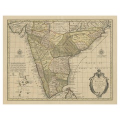
1705 Sanson Map of Southern India and Malabar with an Inset Map
Located in Langweer, NL
Title: 1705 Sanson Map of Southern India and Malabar with an Inset Map
Description: This finely engraved and beautifully hand-colored antique map, published in 1705, depicts south...
Category
Antique Early 1700s Maps
Materials
Paper

$738 Sale Price
20% Off
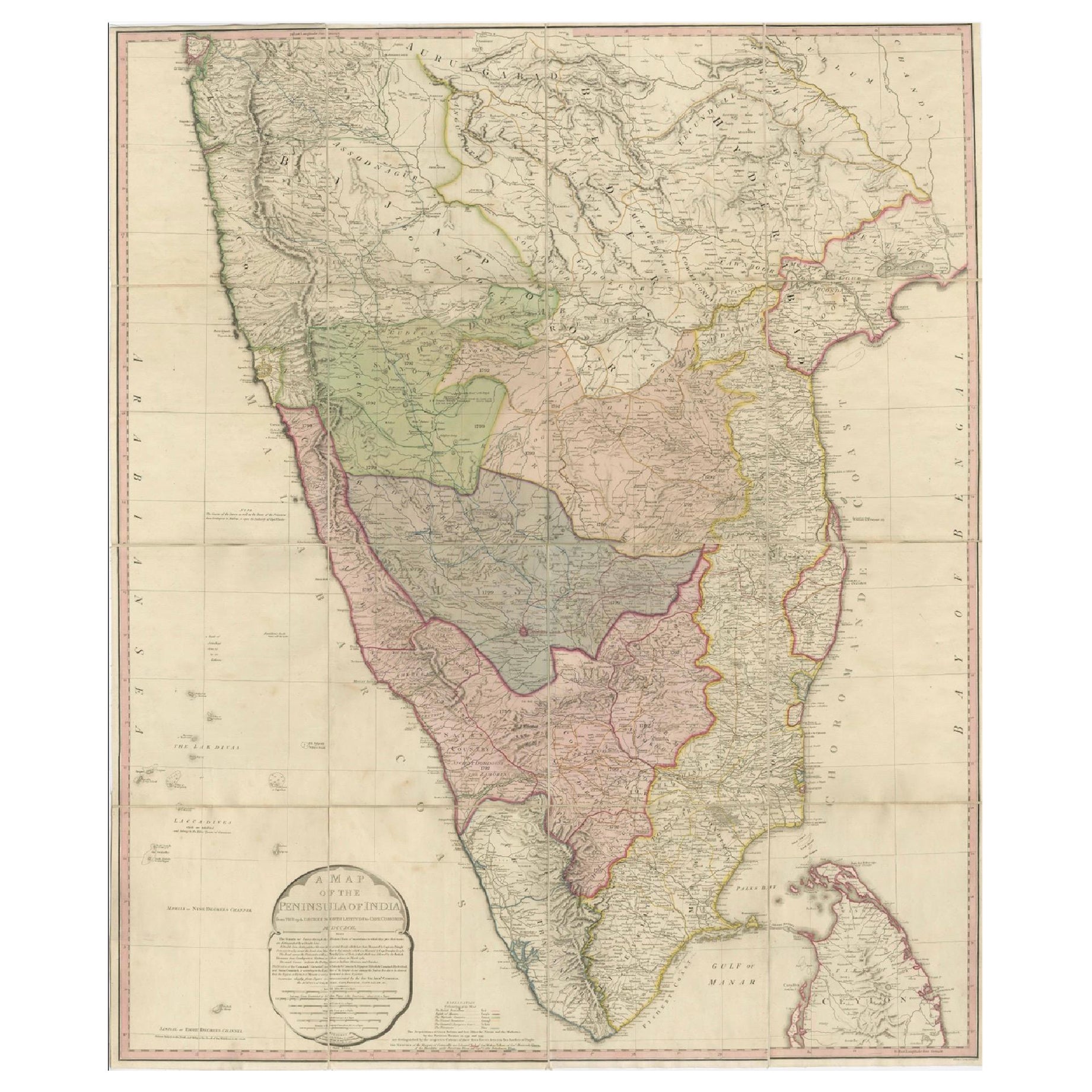
Large Decorative Colonial-Era Map of South India – Peninsula of India, 1800
Located in Langweer, NL
Antique Map of South India – “A Map of the Peninsula of India,” London 1800
This large and detailed antique map titled *A Map of the Peninsula of India* was published in London in 1...
Category
Antique Early 19th Century English Maps
Materials
Linen, Paper

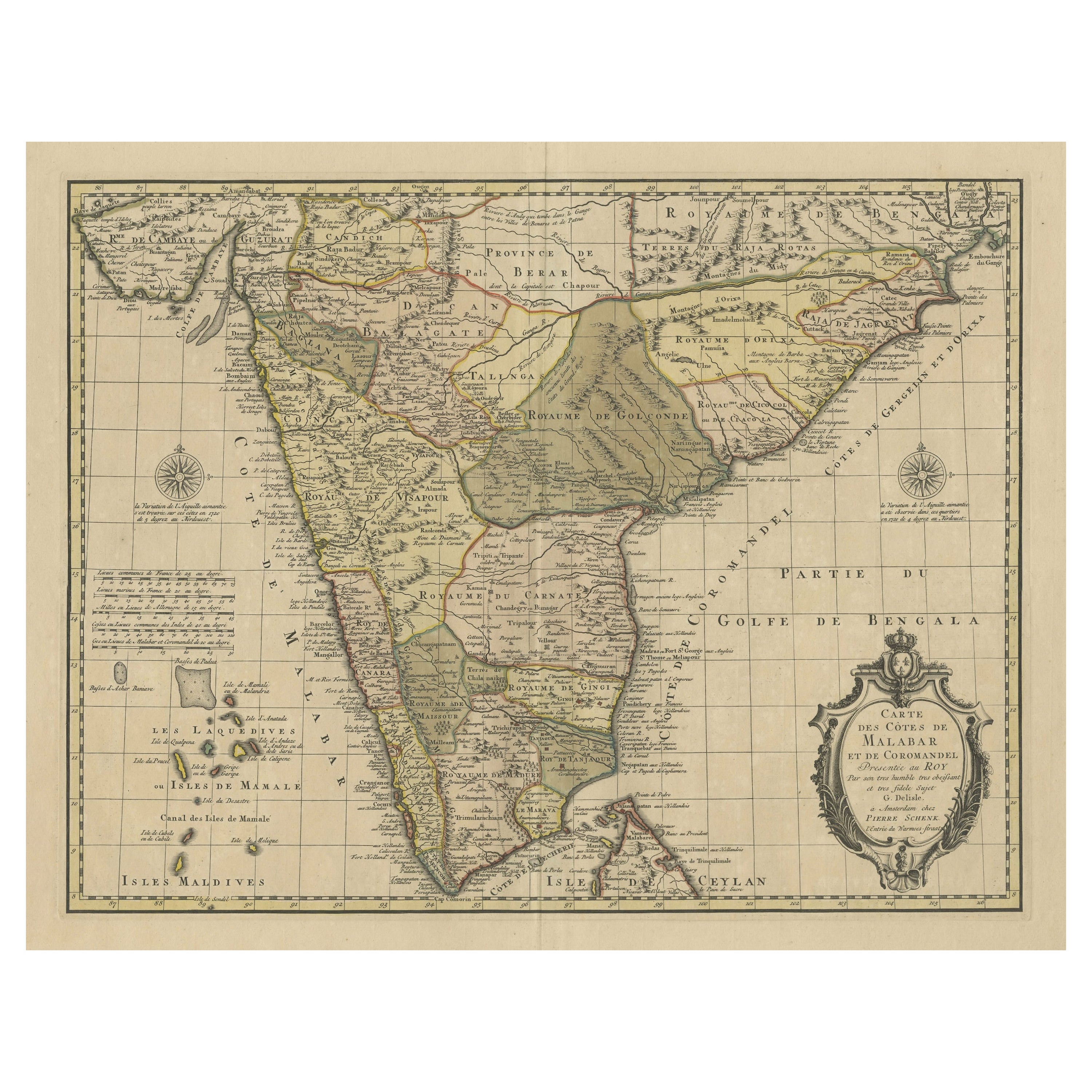
Detailed Decorative Antique Map of the Coast of Malabar and Coromandel, India
Located in Langweer, NL
Antique map titled 'Carte des Côtes de Malabar et de Coromandel'. Finely engraved map of the southern part of India, first issued in 1723 by acclaimed French mapmaker Guillaume De L’Isle. It focuses on trade routes within India, as well as the Coromandel and Malabar Coasts...
Category
Antique Mid-18th Century Maps
Materials
Paper
$1,150 Sale Price
20% Off
You May Also Like
Original Antique Map of India by Dower, circa 1835
Located in St Annes, Lancashire
Nice map of India
Drawn and engraved by J.Dower
Published by Orr & Smith. C.1835
Unframed.
Free shipping
Category
Antique 1830s English Maps
Materials
Paper

Map Of India - Original Lithograph - 19th Century
Located in Roma, IT
Map of India is an original lithograph artwork realized by an Anonymous engraver of the 19th Century.
Printed in the series of "France Pittoresque".
Titled "France Pittoresque".
...
Category
19th Century Modern Figurative Prints
Materials
Lithograph

Antique French Map of Asia Including China Indoneseia India, 1783
Located in Amsterdam, Noord Holland
Very nice map of Asia. 1783 Dedie au Roy.
Additional information:
Country of Manufacturing: Europe
Period: 18th century Qing (1661 - 1912)
Condition: Overall Condition B (Good Used)...
Category
Antique 18th Century European Maps
Materials
Paper

$648 Sale Price
20% Off
Antique 1803 Italian Map of Asia Including China Indoneseia India
Located in Amsterdam, Noord Holland
Antique 1803 Italian Map of Asia Including China Indoneseia India
Very nice map of Asia. 1803.
Additional information:
Type: Map
Country of Manufacturing: Europe
Period: 19th centu...
Category
Antique 19th Century European Maps
Materials
Paper

$584 Sale Price
20% Off
India (Southern Sheet), English antique map by Alexander Keith Johnston, 1901
Located in Melbourne, Victoria
'India (Southern Sheet)', antique lithographic map by Keith Johnston.
Inset maps of 'Bombay Island & Town', 'Madras & Environs', and 'South-Eastern Provinces of India'.
Central vertical fold as issued.
495mm by 625mm (sheet)
Alexander Keith...
Category
Early 20th Century Victorian More Prints
Materials
Lithograph

Original Antique Map of South America. C.1780
Located in St Annes, Lancashire
Great map of South America
Copper-plate engraving
Published C.1780
Two small worm holes to left side of map
Unframed.
Category
Antique Early 1800s English Georgian Maps
Materials
Paper

More Ways To Browse
Voc Antique
Malabar Furniture
Sri Lankan Antique Furniture
Kerala Antique
Kerala Antique Furniture
Antique Coal Mining
Antique Dutch Bible
Antique Louisiana Map
Antique Maps Of Sicily
Iran Map
Map Of Great Britain
Sardinia Map
Antique Map Of Thailand
Antique Wooden Roller
Croatia Map
Kentucky Antique Furniture
Louisiana Antique Furniture
Map Of Ancient Greece