Items Similar to Detailed Decorative Antique Map of the Coast of Malabar and Coromandel, India


Want more images or videos?
Request additional images or videos from the seller
1 of 6
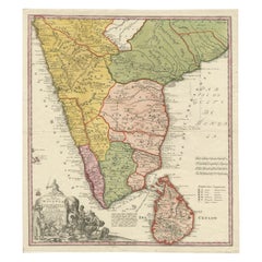
Detailed Decorative Antique Map of the Coast of Malabar and Coromandel, India
About the Item
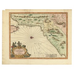
Antique map titled 'Carte des Côtes de Malabar et de Coromandel'. Finely engraved map of the southern part of India, first issued in 1723 by acclaimed French mapmaker Guillaume De L’Isle. It focuses on trade routes within India, as well as the Coromandel and Malabar Coasts. The map shows the Indian subcontinent, from Gujarat and Bengal south. The northern tip of Ceylon, or Sri Lanka, peeks out of the southern border. To the west, the Maldives dot the waters off the Malabar coast.
Rivers, including the mighty Ganges, are indicated, as our mountain ranges. Political boundaries are outlined, with settlements marked by circles or small buildings. Trade routes snake across the terrain, indicated by double dashed lines. They radiate from areas rich in resources, such as the diamond mine of Raolconda [part of the Golconda diamond mines], or from cities at the crossroads of commerce, such as Amandabat [Ahmedabad].
Published by P. Schenk, c. 1730.
- Dimensions:Height: 21.07 in (53.5 cm)Width: 25.2 in (64 cm)Depth: 0.02 in (0.5 mm)
- Materials and Techniques:
- Period:
- Date of Manufacture:circa 1730
- Condition:Wear consistent with age and use. Original/contemporary hand coloring. Age-related toning. Minor wear, blank verso. Original folding line. Please study images carefully.
- Seller Location:Langweer, NL
- Reference Number:
About the Seller
5.0
Platinum Seller
These expertly vetted sellers are 1stDibs' most experienced sellers and are rated highest by our customers.
Established in 2009
1stDibs seller since 2017
1,922 sales on 1stDibs
Typical response time: <1 hour
- ShippingRetrieving quote...Ships From: Langweer, Netherlands
- Return PolicyA return for this item may be initiated within 14 days of delivery.
More From This SellerView All
- Original Antique Map of Malabar, Coromandel 'India' and CeylonLocated in Langweer, NLAntique map titled 'Peninsula Indiae citra Gangem, hoc est Orae celeberrimae Malabar & Coromandel (..)'. Large and attractive original hand colored map of Sri Lanka and the Southern ...Category
Antique Mid-18th Century Maps
MaterialsPaper
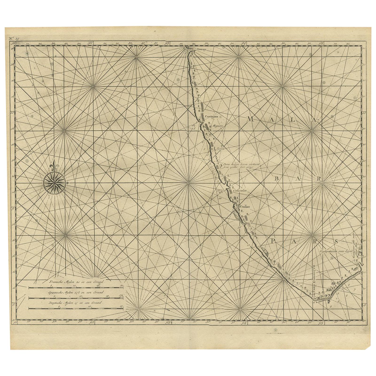
- Antique Map of Malabar Coast by Valentijn, 1726By F. ValentijnLocated in Langweer, NLUntitled sea chart of the coast of Malabar, India. This print originates from 'Oud en Nieuw Oost-Indiën' by F. Valentijn.Category
Antique Early 18th Century Dutch Maps
MaterialsPaper
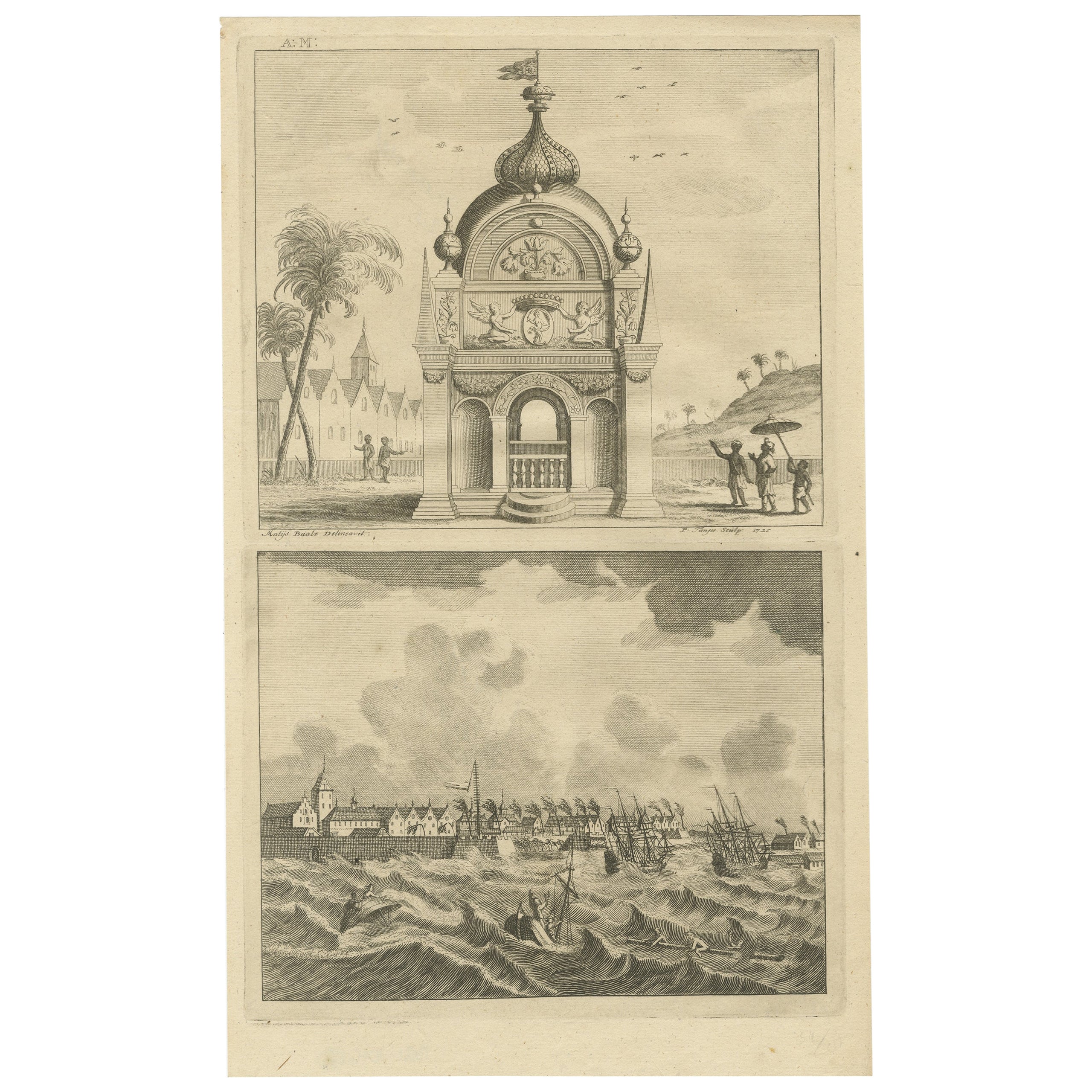
- Antique Print of the Coromandel Coast in India, 1726Located in Langweer, NLAntique print depicting the Coromandel Coast, India. This print originates from 'Oud en Nieuw Oost-Indiën' by F. Valentijn. Artists and Engravers: François Valentijn (1666-1727), a ...Category
Antique 18th Century Prints
MaterialsPaper
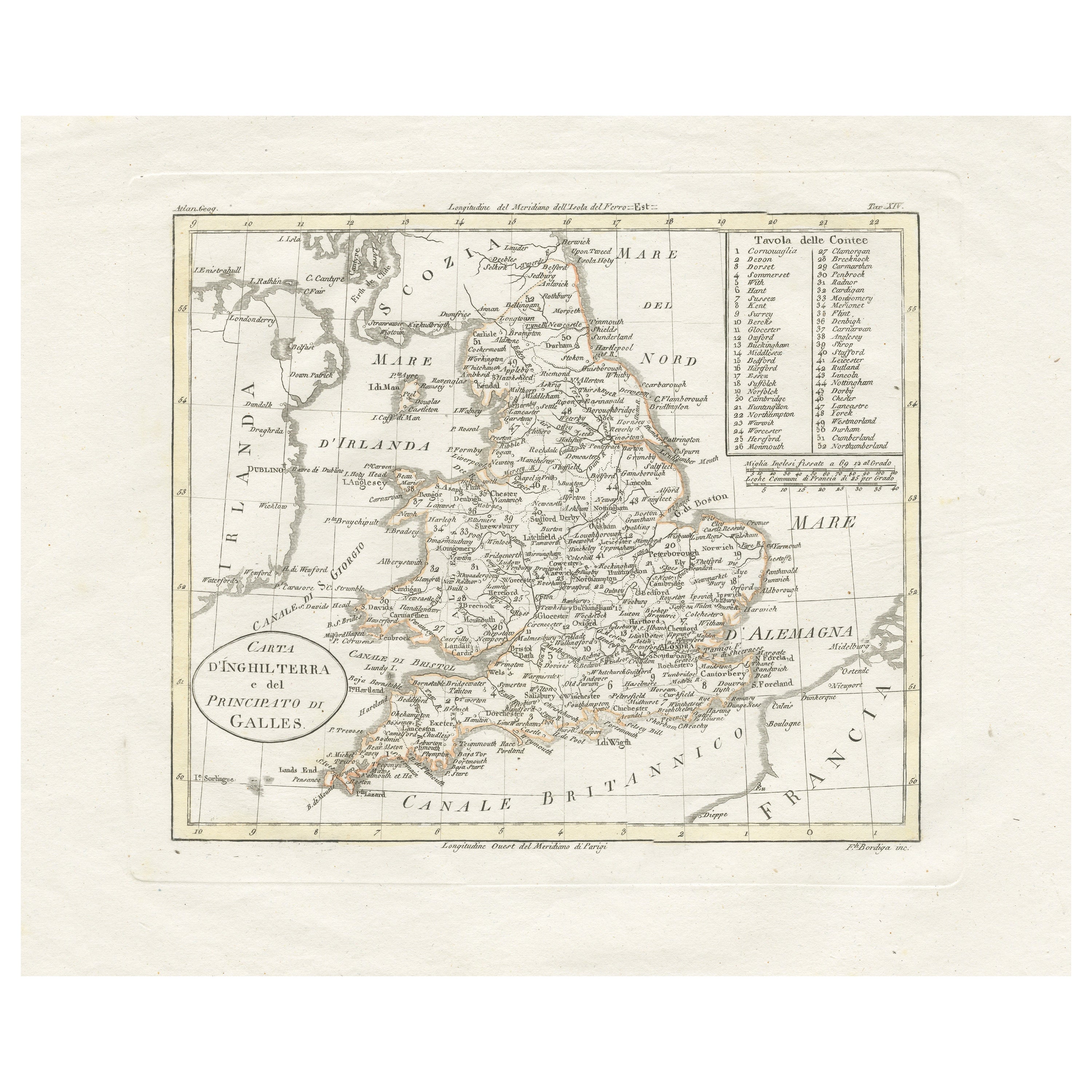
- Detailed Antique Map of Britain, Wales and the Coast of IrelandLocated in Langweer, NLAntique map titled 'Carta d'Inghilterra e del Principato di Galles'. Detailed map of Britain, Wales and the coast of Ireland with a list of counties. This map originates from 'Nuovo ...Category
Antique Mid-19th Century Maps
MaterialsPaper
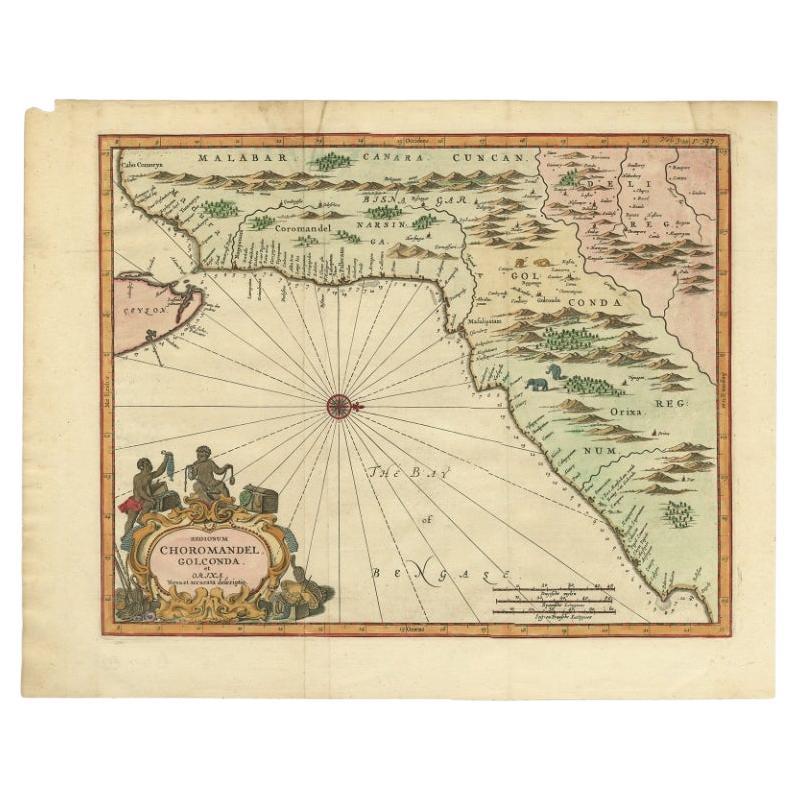
- Antique Map of Choromandel, Golconda and Orixa, Malabar, India, 1744By Philip BaldaeusLocated in Langweer, NLAntique map titled 'Regionum Choromandel, Golconda (..).' Handsome map of Choromandel, Golconda and Orixa, published in 'The True and Exact Description of the Most Celebrated East - ...Category
Antique 18th Century Maps
MaterialsPaper
- Original Detailed Antique Map of the East Coast of Africa, 1747Located in Langweer, NLAntique map titled 'Carte de la coste Orientale d'Afrique - Kaart van de Oostkust van Afrika'. Original antique map of the east coast of Africa. Reaches from Cape of Good Hope an...Category
Antique 1740s Maps
MaterialsPaper

You May Also Like
- Original Antique Map of India. C.1780Located in St Annes, LancashireGreat map of India Copper-plate engraving Published C.1780 Three small worm holes to right side of map and one bottom left corner Unframed.Category
Antique Early 1800s English Georgian Maps
MaterialsPaper

- Map of the Republic of GenoaLocated in New York, NYFramed antique hand-coloured map of the Republic of Genoa including the duchies of Mantua, Modena, and Parma. Europe, late 18th century. Dimension: 25...Category
Antique Late 18th Century European Maps
- Antique Map of Principality of MonacoBy Antonio Vallardi EditoreLocated in Alessandria, PiemonteST/619 - "Old Geographical Atlas of Italy - Topographic map of ex-Principality of Monaco" - ediz Vallardi - Milano - A somewhat special edition ---Category
Antique Late 19th Century Italian Other Prints
MaterialsPaper
- Original Antique Map of The World by Thomas Clerk, 1817Located in St Annes, LancashireGreat map of The Eastern and Western Hemispheres On 2 sheets Copper-plate engraving Drawn and engraved by Thomas Clerk, Edinburgh. Published by Mackenzie And Dent, 1817 ...Category
Antique 1810s English Maps
MaterialsPaper
- Italy, Sicily, Sardinia, Corsica and Dalmatian Coast: A 17th Century Dutch MapBy Theodorus DanckertsLocated in Alamo, CAThis hand colored 17th century Dutch map entitled "Novissima et Accuratissima totius Italiae Corsicae et Sardiniae Descriptio" by Theodore Danckerts depicts the Italian Peninsula in ...Category
Antique Late 17th Century Dutch Maps
MaterialsPaper
- Antique 18th Century Map of the Province of Pensilvania 'Pennsylvania State'Located in Philadelphia, PAA fine antique of the colony of Pennsylvania. Noted at the top of the sheet as a 'Map of the province of Pensilvania'. This undated and anonymous map is thought to be from the Gentleman's Magazine, London, circa 1775, although the general appearance could date it to the 1760's. The southern boundary reflects the Mason-Dixon survey (1768), the western boundary is placed just west of Pittsburgh, and the northern boundary is not marked. The map has a number of reference points that likely refer to companion text and appear to be connected to boundaries. The western and southern boundaries are marked Q, R, S, for example. A diagonal line runs from the Susquehanna R to the Lake Erie P. A broken line marked by many letters A, B, N, O, etc., appears in the east. There are no latitude or longitude markings, blank verso. Framed in a shaped contemporary gilt wooden frame and matted under a cream colored matte. Bearing an old Graham Arader Gallery...Category
Antique 18th Century British American Colonial Maps
MaterialsPaper


Recently Viewed
View AllMore Ways To Browse
India Diamond
Antique Trade Show
India Antique 18th Century
Antique Furniture In Sri Lanka
Antique South Indian Furniture
South Indian Antique Furniture
Antique Sri Lanka
Sri Lankan Antiques
West Indian Antique Furniture
Ceylon Antique Furniture
French Coromandel
Malabar Furniture
Northern France Map
Antique Snake Decorative
Antique Resources
Antique Indian C
Sri Lankan L
Cote France Antiques