Items Similar to Mythical Atlantis Restored - A 1694 Map of the Americas and Ancient Geography


Want more images or videos?
Request additional images or videos from the seller
1 of 11
Mythical Atlantis Restored - A 1694 Map of the Americas and Ancient Geography
$2,292.04
£1,696.77
€1,930
CA$3,157.88
A$3,518.32
CHF 1,836.73
MX$42,717.15
NOK 23,086.52
SEK 21,822.37
DKK 14,695.36
About the Item
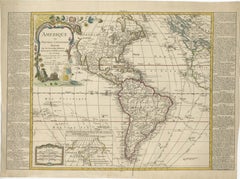
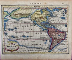
This rare and fascinating map, titled "Atlantis Insula a Nicolao Sanson Antiquitati Restituta" by Guillaume Sanson, presents an unusual interpretation of the Western Hemisphere, combining ancient geographical theories with the evolving understanding of the New World in 1694.
It serves as both an intriguing artifact of early cartography and a glimpse into how explorers and geographers of the 17th century tried to reconcile the mythology of Atlantis with the actual discoveries of new continents.
The map was published in Sanson's renowned *Tabulae Geographicae, Quibus Universa Geographia vetus Continentur*, which aimed to provide insights into both ancient and modern geography.
What makes this particular piece unique is its representation of the Americas under the guise of the mythical island of Atlantis. In the cartouche, Sanson states that this continent is Atlantis, a concept inspired by ancient accounts, particularly Plato's description of the lost civilization. The Americas are divided into ten regions, each named after one of Neptune's ten sons. This fascinating combination of myth and reality showcases the ways in which European cartographers attempted to synthesize ancient lore with their contemporary geographical knowledge.
The map is purely topographical, focusing on landforms without providing detailed names of cities, towns, or other human settlements, with the only cities depicted being the ancient capitals of the Americas—Mexico City and Cuzco. These cities represent the heart of the Aztec and Inca Empires, respectively, reflecting the European fascination with these powerful and mysterious civilizations.
The map features the Great Lakes, albeit in a distorted form, showcasing how knowledge of the interior of North America was still being developed. Additionally, there is a large, mysterious lake located in the western part of North America that acts as the source of a river flowing into the Pacific, hinting at the speculative nature of many early maps, especially regarding inland areas that had yet to be thoroughly explored.
Another interesting element of the map is the inclusion of the coastlines of Europe, Asia, New Guinea, New Zealand, and Australia. These additions reflect the curiosity and ambition of European explorers to chart as much of the known world as possible, juxtaposed against the mythical land of Atlantis. The representation of California as an island, a popular misconception during this period, is present on this map, underscoring the intriguing inaccuracies that persisted in early cartography.
The map's large decorative cartouche is a highlight for collectors and enthusiasts. It is adorned with imagery of Neptune, the Roman god of the sea, along with his ten sons, lending an ornate and almost whimsical character to the work. Such embellishments were typical of 17th-century cartography, where aesthetics often intertwined with function to produce visually captivating works of art. The cartouche also serves as a fascinating reminder of how mythology and reality were often interwoven in early modern European worldviews.
This map's blend of myth, exploration, and evolving geographic understanding makes it a compelling piece for collectors interested in both the history of cartography and the intersection of legend with scientific inquiry. It not only provides insight into the geographic knowledge of the time but also reflects the imaginative ways in which cartographers sought to reconcile newly discovered lands with the tales and myths passed down through antiquity.
- Dimensions:Height: 15.52 in (39.4 cm)Width: 21.5 in (54.6 cm)Depth: 0.01 in (0.2 mm)
- Materials and Techniques:Paper,Engraved
- Period:1690-1699
- Date of Manufacture:1694
- Condition:The condition of this map is quite good, with old hand coloring and wide margins. There is marginal soiling, but it does not affect the main image area. The map remains visually impressive, and its overall state is well-preserved considering age.
- Seller Location:Langweer, NL
- Reference Number:Seller: BHZ107831stDibs: LU3054342602432
About the Seller
5.0
Recognized Seller
These prestigious sellers are industry leaders and represent the highest echelon for item quality and design.
Platinum Seller
Premium sellers with a 4.7+ rating and 24-hour response times
Established in 2009
1stDibs seller since 2017
2,589 sales on 1stDibs
Typical response time: <1 hour
- ShippingRetrieving quote...Shipping from: Langweer, Netherlands
- Return Policy
Authenticity Guarantee
In the unlikely event there’s an issue with an item’s authenticity, contact us within 1 year for a full refund. DetailsMoney-Back Guarantee
If your item is not as described, is damaged in transit, or does not arrive, contact us within 7 days for a full refund. Details24-Hour Cancellation
You have a 24-hour grace period in which to reconsider your purchase, with no questions asked.Vetted Professional Sellers
Our world-class sellers must adhere to strict standards for service and quality, maintaining the integrity of our listings.Price-Match Guarantee
If you find that a seller listed the same item for a lower price elsewhere, we’ll match it.Trusted Global Delivery
Our best-in-class carrier network provides specialized shipping options worldwide, including custom delivery.More From This Seller
View AllDetailed 1795 Map of the Americas with Exploration Tracks and Nice Cartouche
Located in Langweer, NL
This is a very handsome and rare 1795 map of the Americas titled "Amerique ou Nouveau Continent Dressee sur les Nouvelles Relations Decouvertes et Observations" by Jean Baptiste Noli...
Category
Antique 1790s Maps
Materials
Paper
$2,223 Sale Price
20% Off
Antique Map of America with California as an Island by Homann '1710'
Located in Langweer, NL
This antique map, titled "Totius Americae Septentrionalis et Meridionalis," represents a significant cartographic piece from 1710 by Johann Baptist Homann. Here's a description of this remarkable map:
- Title: Totius Americae Septentrionalis et Meridionalis (...)
- Date: Published in 1710 by Johann Baptist Homann.
Description:
This map is a first edition of Johann Baptiste Homann's map of America, and it is notable for several cartographic features and historical representations:
1. California as an Island...
Category
Antique Early 18th Century Maps
Materials
Paper

$2,226 Sale Price
25% Off
Rare North Atlantic and Caribbean Sea Chart: Newfoundland to Venezuela, 1745
Located in Langweer, NL
This impressive map titled "Terra Neuf, en de Custen van Nieu Vranckryck, Nieuw Engeland... Venezuela," published by Louis Renard in 1745, captures the North Atlantic coastline, enco...
Category
Antique 1740s Maps
Materials
Paper
Scarce Latin Edition of Guillaume Delisle's 1700 Map of North America
Located in Langweer, NL
Scarce German Edition of Guillaume Delisle's 1700 Map of North America
This beautifully colored and highly detailed map is a rare Latin edition of Guillaume Delisle's influential 17...
Category
Antique Early 1700s Maps
Materials
Paper
$1,852 Sale Price
20% Off
Excellent Antique Map of America with Unusual Northwest Coast of America, c.1754
Located in Langweer, NL
Description: Antique map titled 'Nieuwe Kaart Van het Westelykste Deel Der Weereld, dienende tot aanwyzing an de Scheepstogten der Nederlanderne Naar West Indie.' Excellent map of America, featuring an unusual northwest coast of America, which includes Martin d'Aguilar's strait which provides for a Northwest Passage via the Great Lakes. The rest of the NW coast...
Category
Antique 1750s Maps
Materials
Paper
$546 Sale Price
20% Off
Antique Map of South American, The West Indies & Most of Africa, Ca.1775
Located in Langweer, NL
Antique map titled 'Carte pour Servir a l' Histoire Philosophique et Politique des Etablissemens et du Commerce des Europeens dans les deux Indes'.
This map is roughly centered o...
Category
Antique 1770s Maps
Materials
Paper

$722 Sale Price
20% Off
You May Also Like
The Americas - Vintage Map - 18th century
Located in Roma, IT
The Americas is a very beautiful vintage map realized in the 18th century by an Italian cartographer.
Very good conditions, on the right side the inscript...
Category
18th Century Figurative Prints
Materials
Paper, Etching

Original Antique Map of South America. C.1780
Located in St Annes, Lancashire
Great map of South America
Copper-plate engraving
Published C.1780
Two small worm holes to left side of map
Unframed.
Category
Antique Early 1800s English Georgian Maps
Materials
Paper

Antique Map - Mare Pacificum - Etching by Johannes Janssonius - 1650s
By Johannes Janssonius
Located in Roma, IT
Mare Pacificum is an antique map realized in 1650 by Johannes Janssonius (1588-1664).
The Map is Hand-colored etching, with coeval watercolorang.
Good conditions with slight foxing...
Category
1650s Modern Figurative Prints
Materials
Etching

North & South America: A 17th Century Hand-colored Map by Jansson & Goos
By Johannes Jansson
Located in Alamo, CA
A 17th century hand-colored map of North & South America entitled "Americae Descriptio" by the cartographer Johannes Jansson, published in Jansson's Atlas Minor in Amsterdam in 1628....
Category
1620s Landscape Prints
Materials
Engraving
Original Antique Map of The Western Hemisphere by Dower, circa 1835
Located in St Annes, Lancashire
Nice map of the Western Hemisphere
Drawn and engraved by J.Dower
Published by Orr & Smith. C.1835
Unframed.
Free shipping
Category
Antique 1830s English Maps
Materials
Paper

Map of the World: An Original 18th Century Hand-colored Map by E. Bowen
Located in Alamo, CA
This is an original 18th century hand-colored map entitled "A New & Correct Chart of All The Known World Laid down according to Mercator's Projection" by Emanuel Bowen. It was published in 1744 in London in John Harris's "Navigantium atque Itinerantium Bibliotheca" or "A Complete Collection of Voyages and Travels". This highly detailed and colorful map depicts the world. as it was known in the mid 18th century. A majority of the northern and central portions of Canada and America are left blank due to the purity of knowledge at the time this map was published.
The map is embellished with four Compass Roses in the lower left, lower center, lower right and center, along with many rhumb lines. There a is a decorative title cartouche in the upper left. This colorful, attractive, historical and interesting 1744 map presents the entire world on Mercator's projection as it was understood in the middle part of the 18th century, before the landmark explorations of Captain’s Cook, Vancouver, Wilkes and others. It is an example of a nautical chart, a type of map that was designed specifically for use by mariners. The map is centered on the equator and includes both the Eastern and Western Hemispheres. The continents of North America, South America, Europe, Africa, and Asia are depicted, as well as various islands in the Atlantic, Pacific, and Indian Oceans. The map is laid out according to the Mercator projection, a type of cylindrical map projection that was developed in the 16th century by Flemish cartographer Gerardus Mercator. This projection has the advantage of preserving angles and shapes, making it useful for navigation. The map presents a paucity of inland detail, particularly for the Americas, but major cities, geographical landmarks, and regions are included. Ocean currents and Tradewinds are identified, as well as the magnetic declination lines or magnetic variance, which refers to the difference between true north and compass north. The continents are color coded, enhancing the beauty of this map. The three compass roses indicate the directions of the cardinal points.
The depiction of the western coast of America, the Pacific and Australia are interesting. There was very little exploration of Australia between the navigations of William Damper in 1699 and Tobias Furneaux in 1773. Most of the maps detail relies on the 17th century Dutch expeditions to Australia's western coast, by Abel Tasman and William Janszoon. Van Diemen's Land (Tasmania) and New Guinea appear connected to the Australian continent. New Zealand appears as a single landmass. North of New Zealand there is a landmass labelled 'Ter d' St. Esprit' which probably represents the New Hebrides Islands. This map precedes the accurate exploration of the South Pacific and east coast of Australia by Captain James Cook later in the 18th century. The map includes ‘Drakes' Port,' the site where Sir Francis Drake supposedly landed in 1579 during his 1579 circumnavigation of the globe. Here he claimed territory for England, restocked, and repaired his vessels. Drake named the region New Albion. The exact location of Drake's Port is a cartographic mystery. Drake's Harbor is believed to be in the region of San Francisco Bay, Bodega Bay, San Pablo Bay...
Category
Mid-18th Century Old Masters Landscape Prints
Materials
Engraving

More Ways To Browse
17th Century American Furniture
Antique Aztec
Cuzco Art
Red Retro Dining Set
Antique Silver Glasses Case
Carlo Scarpa 1934 Chairs
Christofle Marly
1900 Antique Chairs
Glass Table Italian Round
Mid Century Colonial
Alvar Aalto Poster
Geometric Metal Table
Post Modern High Chairs
United Nations
Vintage Vine Rug
Cancel An Order
Antique Framing Square
Silver Metal Chair