Items Similar to Nantucket High-Ways, By-Ways and Not-Ways Decorative Map by Tony Sarg, ca 1930
Want more images or videos?
Request additional images or videos from the seller
1 of 11
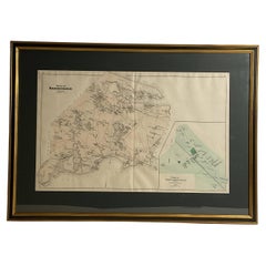
Nantucket High-Ways, By-Ways and Not-Ways Decorative Map by Tony Sarg, ca 1930
$1,750
£1,321.78
€1,527.60
CA$2,454.64
A$2,730.19
CHF 1,428.92
MX$33,299.35
NOK 17,954.96
SEK 16,888.96
DKK 11,402.04
About the Item
Vintage Nantucket High-Ways, By-Ways and Not-Ways Decorative Map by Tony Sarg, (Nantucket: 1880 - 1942) circa 1930, a decorative tourist map of Nantucket Island with details of roadways and paths, with island place names. This map was adopted by Young's Bicycle Shop on Nantucket and re-issued in a smaller size over a number of years in the 1930s and perhaps 1940s. This one does not bear Sarg's signature but I have seen others that were signed and remarqued by him. I have never seen one this large. It is a pretty scarce map that does not appear often on the market.
This map was used in the field, as should have been, and consequently has tears and loss around the edges. The color remains strong and true. It has been freshly mounted in conservation matting and a bird's eye maple frame.
Measures: 19-1/4 in x 34 in
Framed: 21-5/8 in x 36.25
Anthony Frederick Sarg was born in Guatemala in 1880, and after living in Germany, England and New York, he purchased a house on Nantucket in 1921 with his wife and daughter (the artist Mary Sarg Murphy).
Starting as an artist for the Saturday Evening Post, he became best known as an illustrator of children’s books. He was fond of creating animal characters to both educate and entertain young readers, and was noted for his use of whimsy and humor. His books often involved moving parts, a proclivity that led to his creating a variety of toys and puzzles.
Sarg was also extremely important as the reviver of marionette theater in America. In 1935 he also designed the first animated window display for Macy's Department Store, and continued to create new designs for their holiday windows until his death in 1942. He was also the inventor of the first hot air balloons for the Macy’s Thanksgiving Day Parade.
On Nantucket he opened the Tony Sarg Shop at 38 Centre Street, later relocated in 1929 to the corner of Easy Street and Steamboat Wharf where it became Tony Sarg's Curiosity Shop. He hand crafted and sold a variety toys, puppets, prints, fabrics, wall-paper, decoupage decorated pantry boxes and other folk art. He is especially remembered on-island for his maps, posters and Nantucket theme decorated boxes.
A major collection of his work is held by the Nantucket Historical Association, and was featured in an exhibition at the Fair Street Museum in 1983. He is currently the subject of a traveling exhibit curated by the Norman Rockwell Museum which is currently on display at the Nantucket Whaling Museum.
- Creator:Tony Sarg (Designer)
- Dimensions:Height: 21.63 in (54.95 cm)Width: 36.25 in (92.08 cm)Depth: 0.75 in (1.91 cm)
- Style:Other (Of the Period)
- Materials and Techniques:Paper,Other
- Place of Origin:
- Period:
- Date of Manufacture:Circa 1930
- Condition:Wear consistent with age and use. Minor losses.
- Seller Location:Nantucket, MA
- Reference Number:Seller: AD - 292-43 EEY1stDibs: LU903942102922
About the Seller
5.0
Platinum Seller
Premium sellers with a 4.7+ rating and 24-hour response times
1stDibs seller since 2010
272 sales on 1stDibs
Typical response time: 1 hour
- ShippingRetrieving quote...Shipping from: Nantucket, MA
- Return Policy
Authenticity Guarantee
In the unlikely event there’s an issue with an item’s authenticity, contact us within 1 year for a full refund. DetailsMoney-Back Guarantee
If your item is not as described, is damaged in transit, or does not arrive, contact us within 7 days for a full refund. Details24-Hour Cancellation
You have a 24-hour grace period in which to reconsider your purchase, with no questions asked.Vetted Professional Sellers
Our world-class sellers must adhere to strict standards for service and quality, maintaining the integrity of our listings.Price-Match Guarantee
If you find that a seller listed the same item for a lower price elsewhere, we’ll match it.Trusted Global Delivery
Our best-in-class carrier network provides specialized shipping options worldwide, including custom delivery.More From This Seller
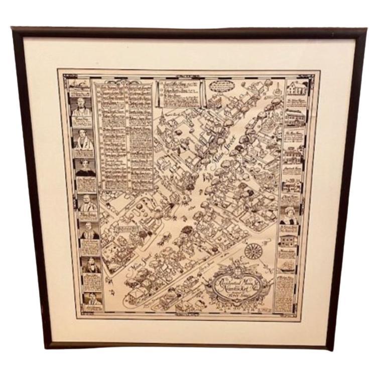
View AllTony Sarg Map of Nantucket Town, 1937
By Tony Sarg
Located in Nantucket, MA
Tony Sarg Map of Residential Main Street, Nantucket, 1937, a black and white printed map of our historic downtown area, with images of each building, street names and whimsical figur...
Category
Vintage 1930s American Other Maps
Materials
Paper

19th Century Chart of New England Coast, 1847
By U.S. Government
Located in Nantucket, MA
19th Century Chart of New England Coast: the U.S. Coast Survey Sketch A - Section 1, a triangulation chart showing the progress of the survey and details along the New England coas...
Category
Antique 1840s American Other Maps
Materials
Paper

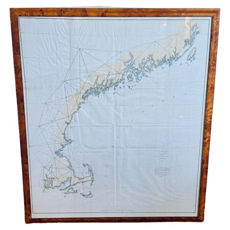
Large U.S. Coast and Geodetic Survey Chart A of the Atlantic Coast, 1877
Located in Nantucket, MA
Large U.S. Coast and Geodetic Survey Chart A of the Atlantic Coast, 1877, re-issued in February 1881, a printed paper laid down on linen navigational chart of the U.S. Atlantic coast...
Category
Antique 1880s American Other Maps
Materials
Linen

Print of Nantucket Daydreams, by Henry S. Wyer, Nantucket, circa 1900
Located in Nantucket, MA
Antique Print of Nantucket Daydreams, by Henry S. Wyer, Nantucket, circa 1900, a period print depicting a gentleman in overstuffed wing chair by the hearth, a copy of Nantucket's "Inquirer and Mirror" open on lap, smoking a cigar and leaning back lost in thought: in the curls of smoke are simple sketches of many iconic Nantucket landmarks and views. Flanking the fireplace in place of tiles are a series of miniature copies of eight of H.S. Wyer's photographs. This is one of the rarest of antique Nantucket prints...
Category
Antique Early 1900s American Late Victorian Prints
Materials
Paper
Nantucket Captain's House Watercolor by Doris & Richard Beer, circa 1940
By Richard Beer (American), Doris Beer
Located in Nantucket, MA
Vintage Nantucket Watercolor by Doris & Richard Beer, circa 1940, a watercolor on paper view of Captain's Houses, signed in pencil lower right. Doris and Richard Beer (1898-1967 and 1893-1959 respectively) produced a well-known series of watercolor miniatures featuring popular Nantucket scenes. Working at their Wharf Head Studio on Old North Wharf for 18 years, the couple worked together on these copyrighted creations, photo-duplicating Doris's line sketch and Doris and Richard completing the watercolor.
One of a large collection of excellent Beer watercolors...
Category
Mid-20th Century American Other Paintings
Materials
Paper
Nantucket Watercolor of Old North Wharf, by Doris and Richard Beer, circa 1940
Located in Nantucket, MA
Vintage Nantucket Watercolor of Old North Wharf, by Doris and Richard Beer, circa 1940, a watercolor on paper view of shell lane down center of ol...
Category
Vintage 1940s American Folk Art Paintings
Materials
Paper

You May Also Like
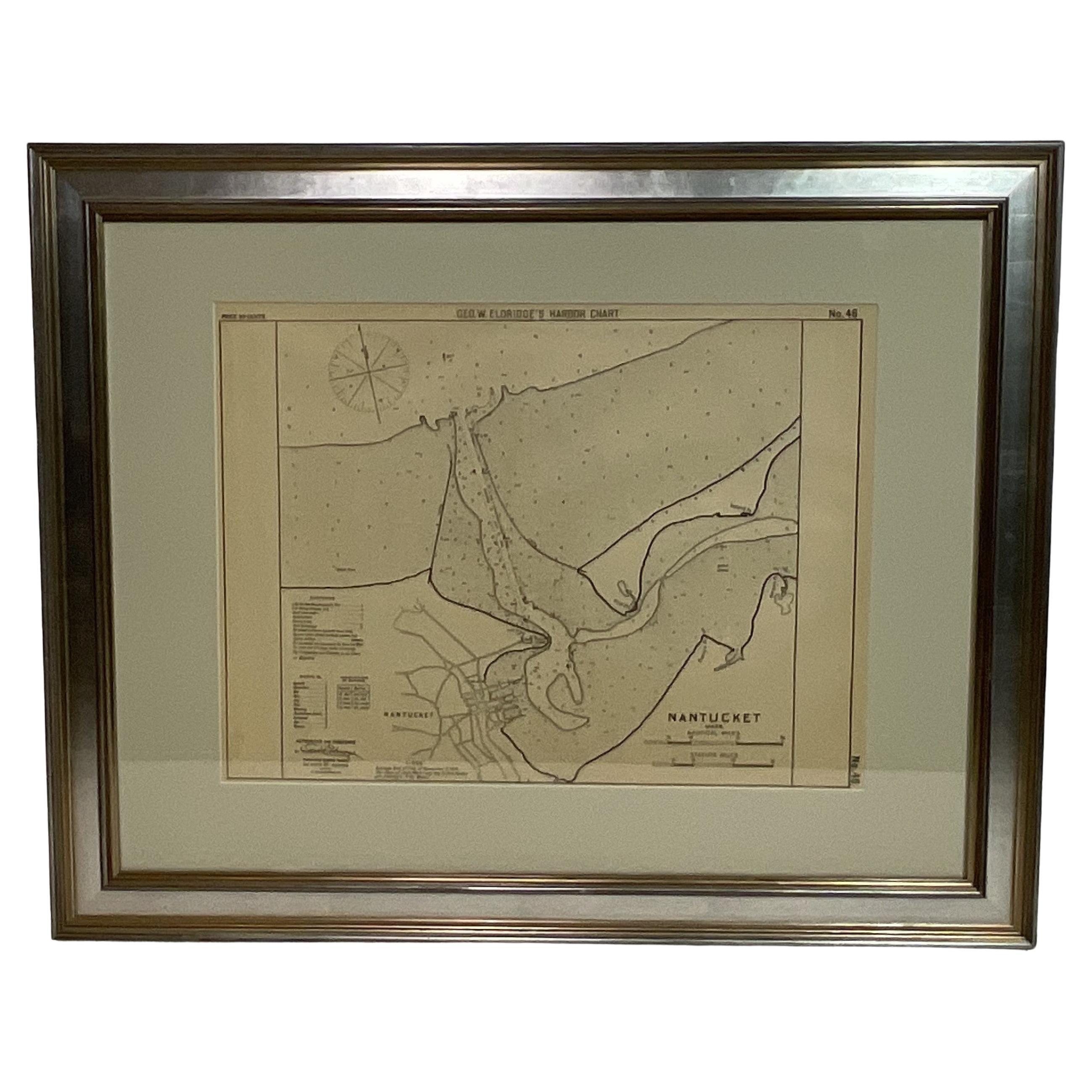
1907 Chart of Nantucket Harbor by George Eldridge
Located in Norwell, MA
Chart of Nantucket Harbor from 1907 by cartographer George W. Eldridge. The chart shows the channel passing by the jetty into the harbor, by Brant Point to Steamboat Wharf. Also show...
Category
Antique Early 1900s North American Maps
Materials
Paper

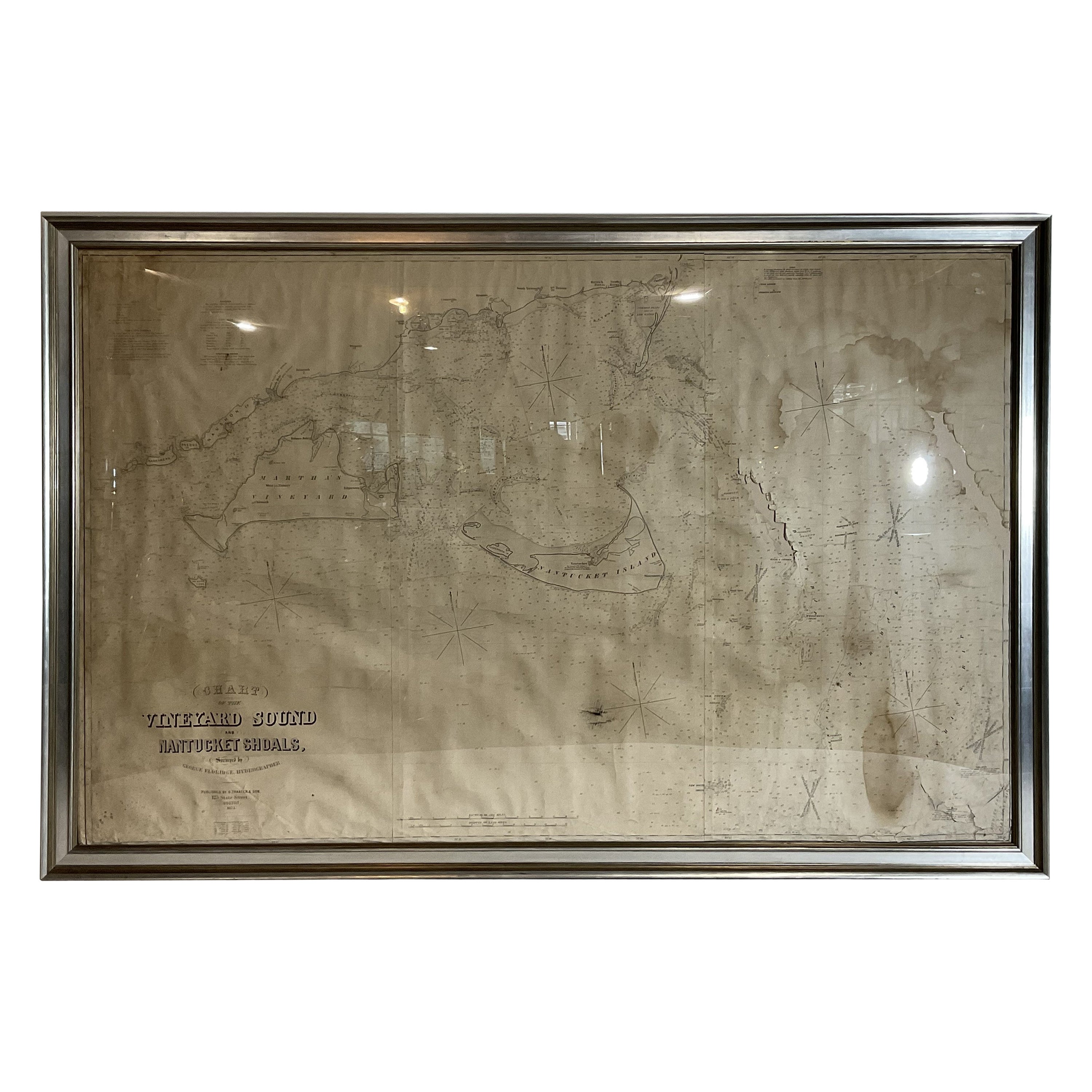
1873 Martha's Vineyard and Nantucket Chart
Located in Norwell, MA
Original chart of Nantucket and Martha's Vineyard by George Eldridge, Cartographer, 125 State Street, Boston. Dated 1873. Mounted to canvas. Also showing the coast of Cape Cod includ...
Category
Antique 1870s North American Maps
Materials
Paper

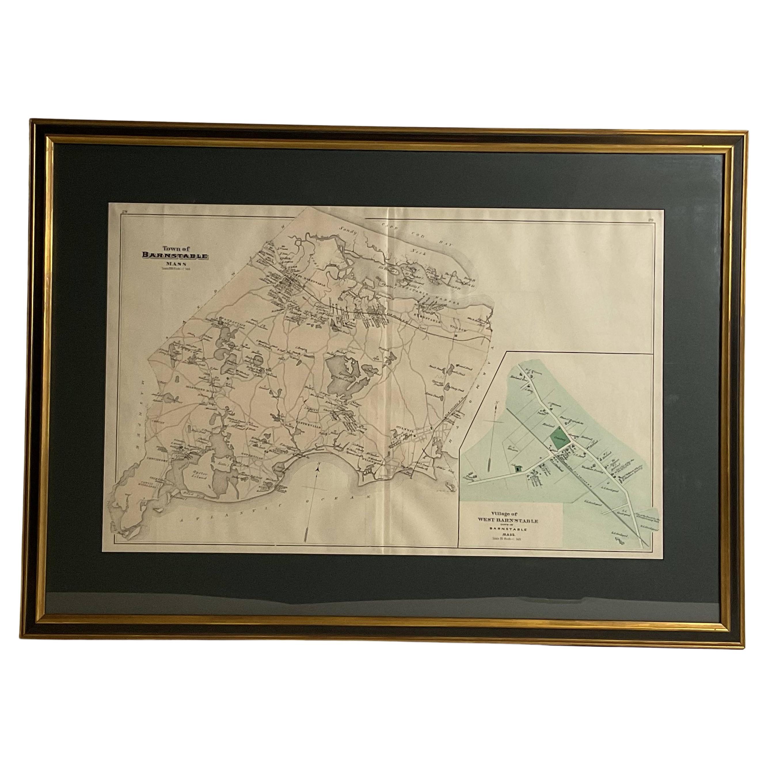
Oyster Harbors Osterville Centerville Cotuit Sandy Neck Map
Located in Norwell, MA
Barnstable country map from the nineteenth century. The map shows the Atlantic coast from Cotuit Highlands past Hyannisport, Hyannis, Sandy Neck, Marstons, Mills, etc., This map is a...
Category
Antique 1890s North American Prints
Materials
Paper
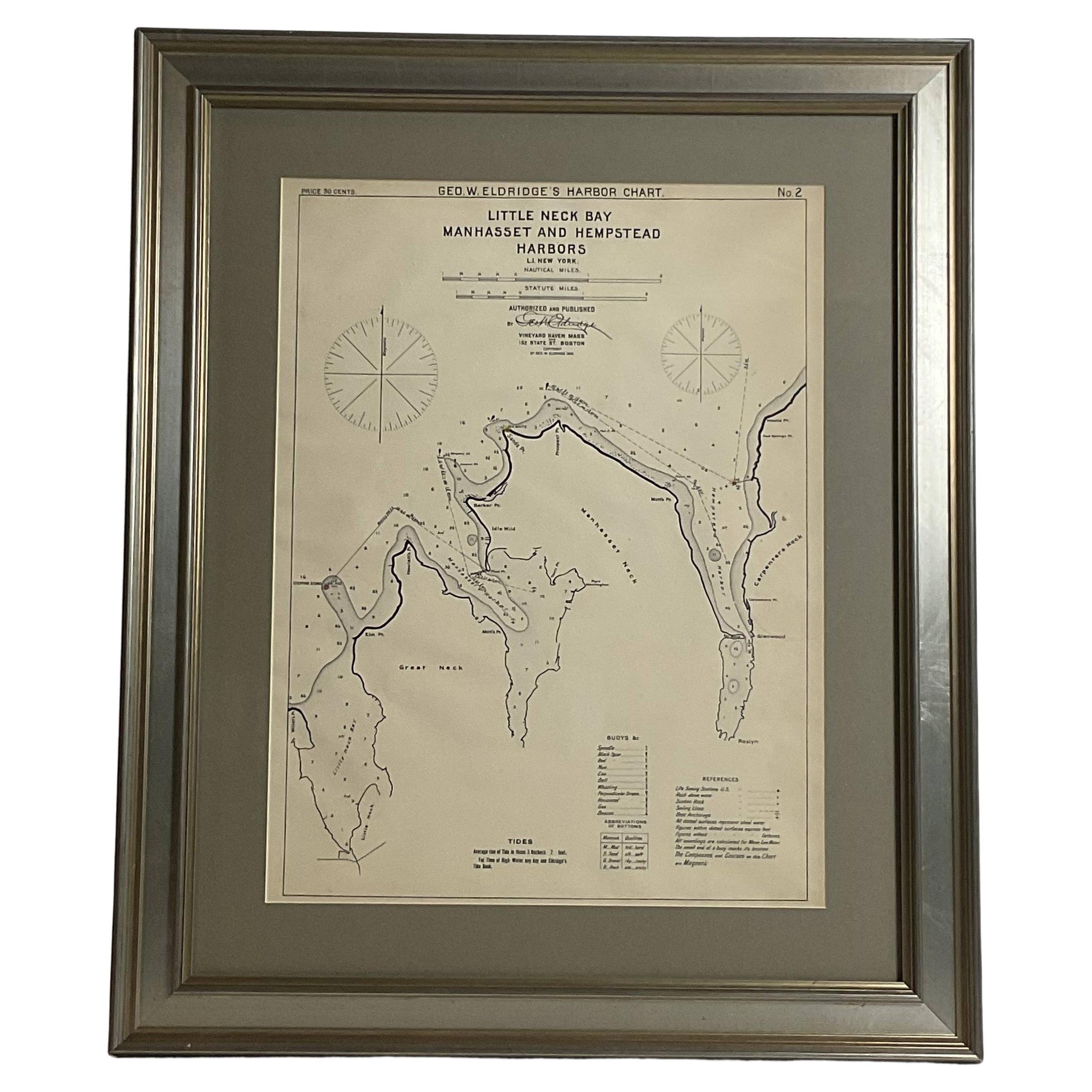
Mariners charts of Massachusett Long Island by George Eldridge 1901
Located in Norwell, MA
Nautical Chart showing the harbor and local waters of the Little Neck Bay, Manhasset and Hempstead Harbors. The chart displays depths, buoys, lighthouses, etc., Shown is Manhasset Ne...
Category
Antique Early 1900s North American Prints
Materials
Paper

1901 Nautical Chart Showing Woods Hole, Mass
Located in Norwell, MA
Rare 1901 chart of Woods Hole, Mass., showing Buzzards Bay, Penzance Point, Nonamesset Island, Downtown Woods Hole, Parker Neck, Nobska Head, Vineyard Sound, Woods Hole Golf Club, Ra...
Category
Antique Early 1900s North American Maps
Materials
Paper
1891 Map of Norfolk County Massachusetts
Located in Norwell, MA
1891 map of Norfolk county Massachusetts including the towns of Wrentham, Franklin, Medfield, Sherborn, Norwood etc., measures: 23 x 31.
Category
Antique 19th Century Maps

More Ways To Browse
The Vintage Map
Vintage Travel Posters England
Large Vintage Map
Large Wall Maps
Used Marionettes
Department Store Display
Birds Eye Maple Frame
Vintage Toys 1930s
Vintage Puzzles
Nantucket Wall Art
Vintage Bicycle Poster
Wall Puppet
Vintage Decoupage Paper
Vintage Bear Toy
Nantucket Signs
Nantucket Folk Art
Birds Eye Maple Box
Vintage Bird Toy