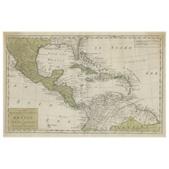
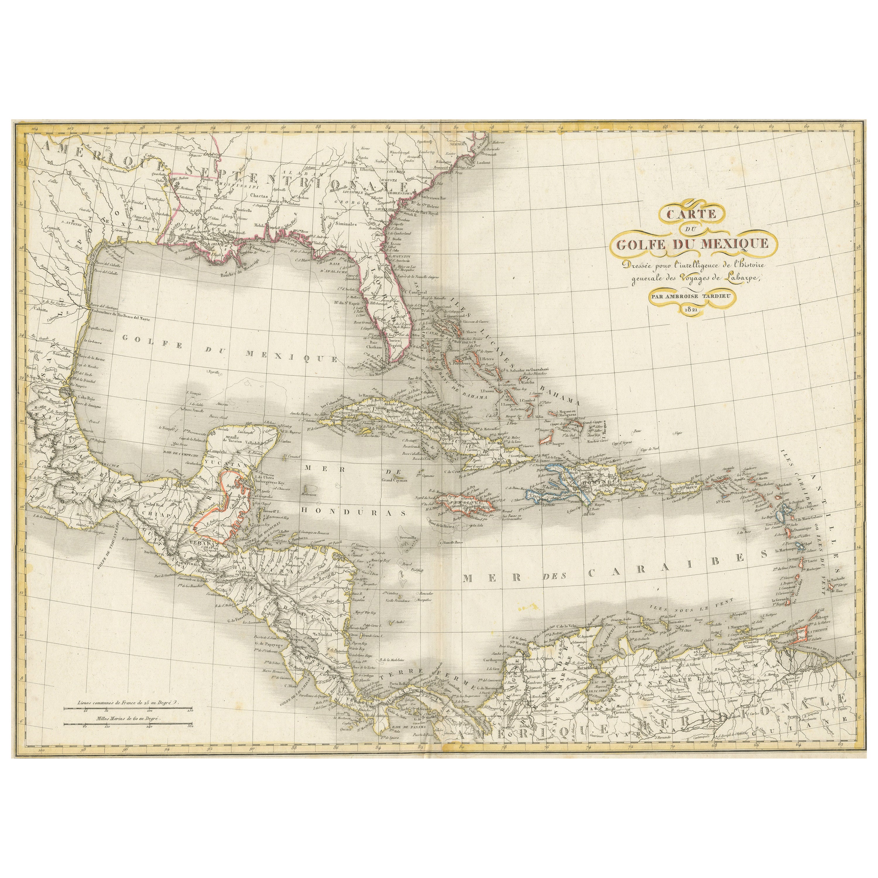
Old Map the Gulf of Mexico, the Caribbean and Northern South America, ca.1765
View Similar Items


Want more images or videos?
Request additional images or videos from the seller
1 of 6
Old Map the Gulf of Mexico, the Caribbean and Northern South America, ca.1765
About the Item
- Dimensions:Height: 20.28 in (51.5 cm)Width: 17.33 in (44 cm)Depth: 0 in (0.01 mm)
- Materials and Techniques:
- Period:
- Date of Manufacture:circa 1765
- Condition:
- Seller Location:Langweer, NL
- Reference Number:Seller: BG-122651stDibs: LU3054326373542
About the Seller
5.0
Platinum Seller
These expertly vetted sellers are 1stDibs' most experienced sellers and are rated highest by our customers.
Established in 2009
1stDibs seller since 2017
1,933 sales on 1stDibs
More From This SellerView All
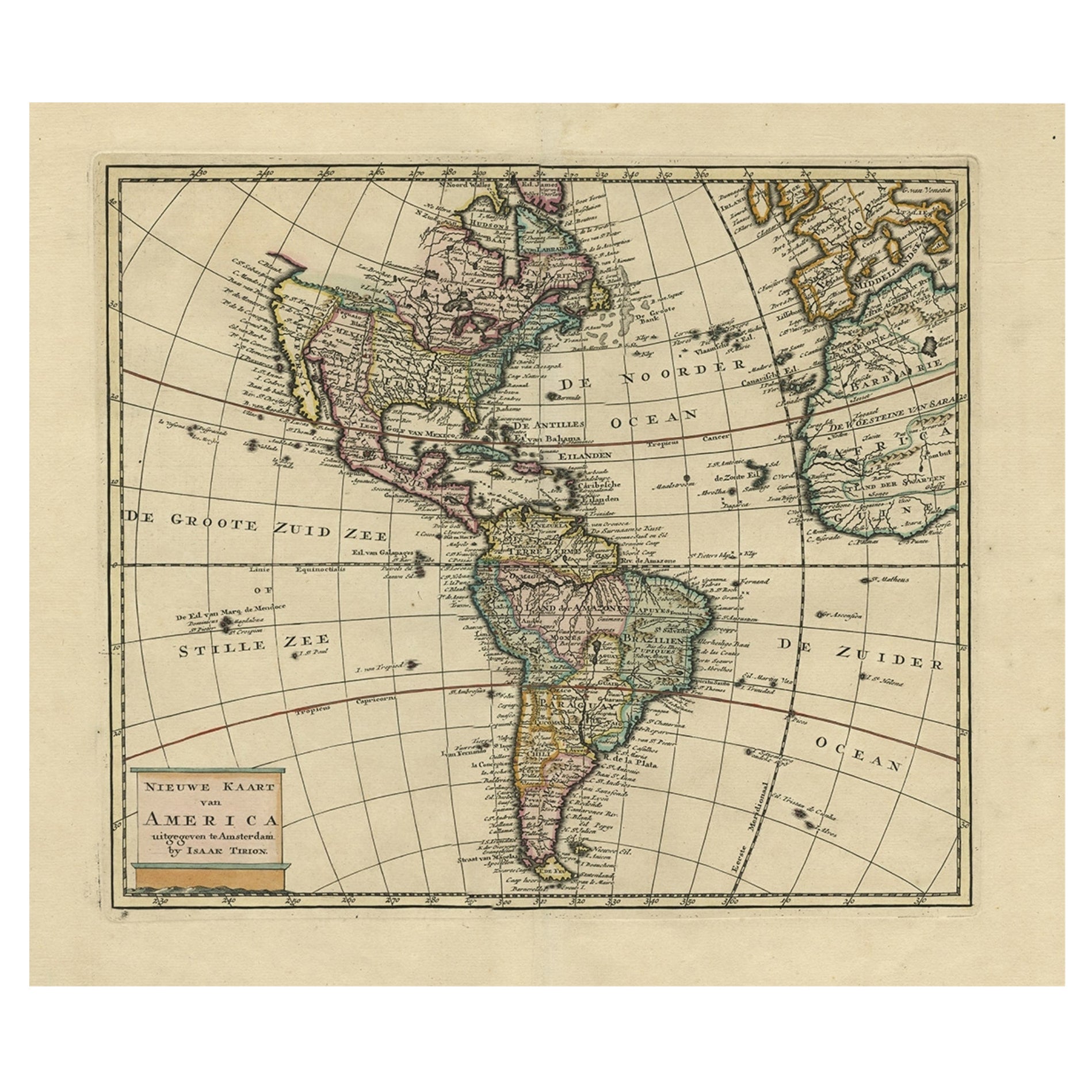
- Antique Hand-Coloured Map of North and South America, ca.1765Located in Langweer, NLDescription: Antique map titled 'Nieuwe Kaart van Amerika.' Attractive map of North and South America, the western part of Africa and south west Europe. Source unknown, to be determi...Category
Antique 1760s Maps
MaterialsPaper
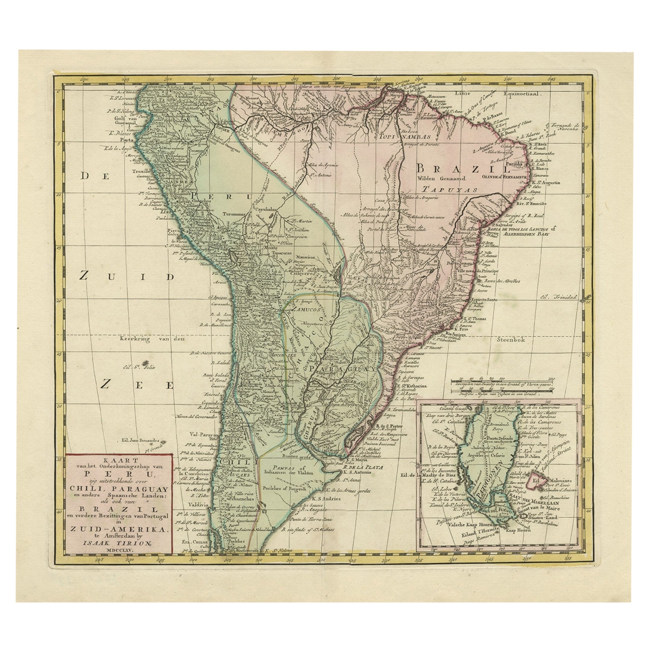
- Attractive Antique Hand-Coloured Map of South America, ca.1765Located in Langweer, NLAntique map titled 'Kaart van het Onderkoningschap van Peru zig uitstrekkende: over Chile, Paraguay en andere Spaansche Landen als ook van Brazil en verdere Bezittingen van Portugal ...Category
Antique 1760s Maps
MaterialsPaper
- Engraving of a Map of Florida, the Gulf Coast, Caribbean & Central America, 1728Located in Langweer, NLThis exceptional antique map, titled "Nouvelle Carte Marine de Toute les Cotes de l´Amerique" and alternatively known as "Nieuwe groote en seer Curieuse Paskaart van Geheel-WestIndie...Category
Antique Mid-18th Century European Maps
MaterialsPaper
 $12,356 Sale Price25% OffFree Shipping
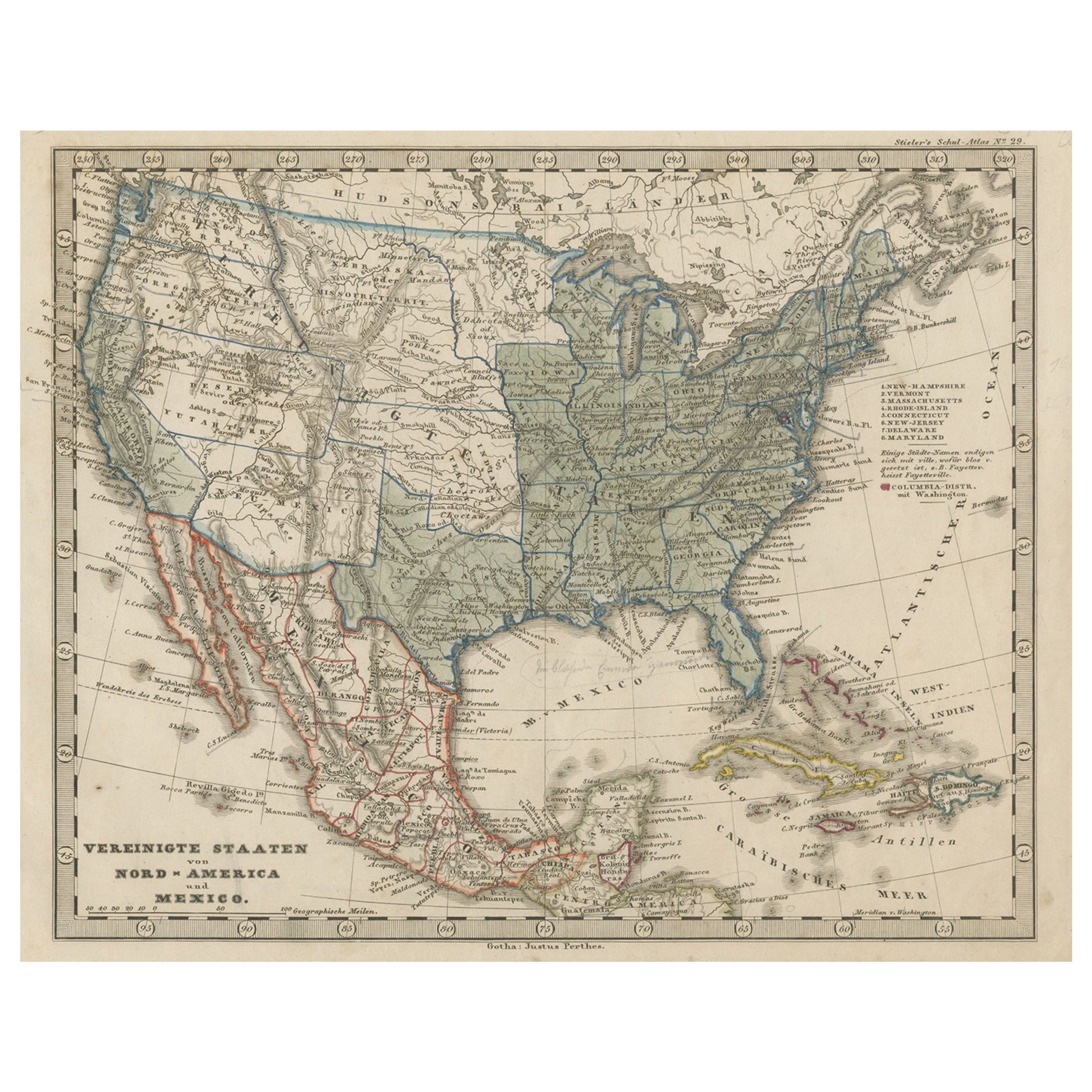
 - Old Map the United States and Central America, Including Mexico, ca.1860Located in Langweer, NLAntique map titled 'Vereinigte Staaten von Nord America und Mexico'. Old map the United States and Central America, including Mexico. This print originates from 'Stieler's Schul-...Category
Antique 1860s Maps
MaterialsPaper
- Antique Map of South America by Tirion 'circa 1765'Located in Langweer, NLAntique map titled 'Kaart van het Onderkoningschap van Peru, zig uitstrekkende over Chili, Paraguay en andere Spaansche Landen: als ook van Brazil en verdere Bezittingen van Portugal...Category
Antique Mid-18th Century Maps
MaterialsPaper
- Antique Map of the Northern Part of South America by J. Tallis, circa 1851Located in Langweer, NLA decorative and detailed mid-19th century map of the northern part of South America (including modern day Venezuela, Colombia, Ecuador, Guyana, Suriname and French Guiana) which was drawn and engraved by J. Rapkin (vignettes by H. Winkles & W. Lacey) and published in John Tallis & Co.'s The Illustrated Atlas (London & New York: circa 1851). The Illustrated Atlas, published from 1849 onwards, was the last decorative world atlas. The 'Venezuela, New Granada...' map was typical of the many Fine ones which appeared in this work with its decorative border and attractive vignettes. Illustrated are views of Mount Chimborazo, Ecuador; the 'Fall of the Bagota' (Tequendama Falls, Colombia); Rheas and a prospect of Paramaribo Harbour (Dutch Guiana...Category
Antique Mid-19th Century Maps
MaterialsPaper
 $196 Sale Price34% Off


You May Also Like
- Original Antique Map of South America. C.1780Located in St Annes, LancashireGreat map of South America Copper-plate engraving Published C.1780 Two small worm holes to left side of map Unframed.Category
Antique Early 1800s English Georgian Maps
MaterialsPaper

- Original Antique Map of South America, circa 1830Located in St Annes, LancashireGreat map of South America Copper plate engraving Published by Butterworth, Livesey & Co., circa 1830 Unframed.Category
Antique Early 1800s English Other Maps
MaterialsPaper

- Original Antique Map of South America by Thomas Clerk, 1817Located in St Annes, LancashireGreat map of South America Copper-plate engraving Drawn and engraved by Thomas Clerk, Edinburgh. Published by Mackenzie And Dent, 1817 Unframed.Category
Antique 1810s English Maps
MaterialsPaper
- Original Antique Map of Ancient Greece, Phocis, Gulf of Corinth, 1787Located in St Annes, LancashireGreat map of Ancient Greece. Showing the region of Phocis, including the Gulf of Corinth Drawn by J.D. Barbie Du Bocage Copper plate engraving by P.F Tardieu Original hand c...Category
Antique 1780s French Other Maps
MaterialsPaper
- Old Nautical Map of CorsicaLocated in Alessandria, PiemonteST/556/1 - Old map of Corsica isle, surveyed by Captain Hell, of the French Royal Navy in 1824, engraved and published on 1874, with additions and corre...Category
Antique Early 19th Century English Other Prints
MaterialsPaper
 $351 Sale Price20% Off
 - Old Horizontal Map of EnglandBy TassoLocated in Alessandria, PiemonteST/520 - Old rare Italian map of England, dated 1826-1827 - by Girolamo Tasso, editor in Venise, for the atlas of M.r Le-Sage.Category
Antique Early 19th Century Italian Other Prints
MaterialsPaper
 $237 Sale Price20% Off


Recently Viewed
View AllMore Ways To Browse
Islands Of Caribbean
18th C American
18th C American Furniture
South Indian Furniture
American Server
Mexican 18th Century
Map South America
Map Of South America
Mexican 18th Century Furniture
Mexican Map
Mexico Map
Maps Of Mexico
Mexican Engraved
Old American Maps
Antique Caribbean
Antique Tires
Tire Antique
South Indian Antique Furniture