Items Similar to Rare Antique Map of the Moghul Empire, ca.1725


Want more images or videos?
Request additional images or videos from the seller
1 of 5
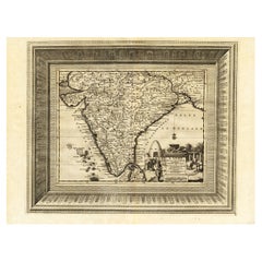
Rare Antique Map of the Moghul Empire, ca.1725
About the Item
Antique map titled 'Oost-Indize Voyagie door William Hawkins van Suratte gedaan na 't Hof van den Grooten Mogol tot Agra. - Voyage des Indes Orientales fait par Guillaume Hawkins de Surate vers le Cour du Grand Mogol jesqu'a Agra (..).'
This map shows the extend of the Mughal Empire, which includes Pakistan, northern India, from Golconda to Afghanistan and eastwards to Bengal and the Ganges river. Decorative cartouche with VOC merchants at court. Extremely rare in this edition.
This plate originates from the very scarse: 'La galerie agreable du monde (...).Tome premier des Indes Orientales.', published by P. van der Aa, Leyden, c. 1725. This famous work was published in 66 parts and is the biggest print / map book ever published. Van der Aa incorporated plates by other publishers such as Blaeu, Visscher, de Wit, meurs, Halma, Mortier, Allard in this work and often added broad decorative borders. Probably the costliest and complete universal geographic work ever produced. It is said that only 100 copies were printed. Ref: Koeman Aa9; Phillips 2780 note. This plate was originally published a Dutch translation of a travel narrative. Van der Aa published 130 translations of important 15th, 16th and 17th Century Travel Narratives to the America, Africa and Asia, which were issued in 28 volumes in the early part of the 18th Century. Many of them are extremely scarse or unobtainable. The decorative borders were added and are typical for this edition.
Artists and Engravers: Pieter van der Aa (Leiden 1659-1733) was a Dutch publisher best known for preparing maps and atlases. The Galerie Agreable contains plates and maps by the best Dutch engravers: Luiken, Goeree, Mulder, Stoopendaal, de Hooghe, ao.
- Dimensions:Height: 14.97 in (38 cm)Width: 19.3 in (49 cm)Depth: 0 in (0.02 mm)
- Materials and Techniques:
- Period:1720-1729
- Date of Manufacture:circa 1725
- Condition:Wear consistent with age and use. Condition: Good. General age related toning and occasional light staining from handling. Paper edge uncut and thus irregular and with occasional small tears. Please study image carefully.
- Seller Location:Langweer, NL
- Reference Number:
About the Seller
5.0
Platinum Seller
These expertly vetted sellers are 1stDibs' most experienced sellers and are rated highest by our customers.
Established in 2009
1stDibs seller since 2017
1,947 sales on 1stDibs
Typical response time: <1 hour
- ShippingRetrieving quote...Ships From: Langweer, Netherlands
- Return PolicyA return for this item may be initiated within 14 days of delivery.
More From This SellerView All
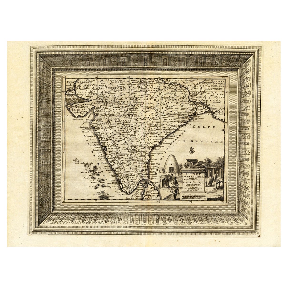
- Rare Engraved Antique Map of India with Elephants in the Cartouche, c.1725Located in Langweer, NLAntique map titled 'L'Inde de ca le Gange suivant les nouvelles observations (..)'. Detailed map of India, with part of Sri Lanka. Compass rose and decorative cartouche lower rig...Category
Antique 18th Century Maps
MaterialsPaper
- Rare Antique Map of the Middle East, ca.1690Located in Langweer, NLDescription: Antique print, untitled. Two decorative maps on one sheet of the middle east in biblical times. Source unknown, to be determined. Artists and Engravers: Anonymous...Category
Antique 1690s Prints
MaterialsPaper
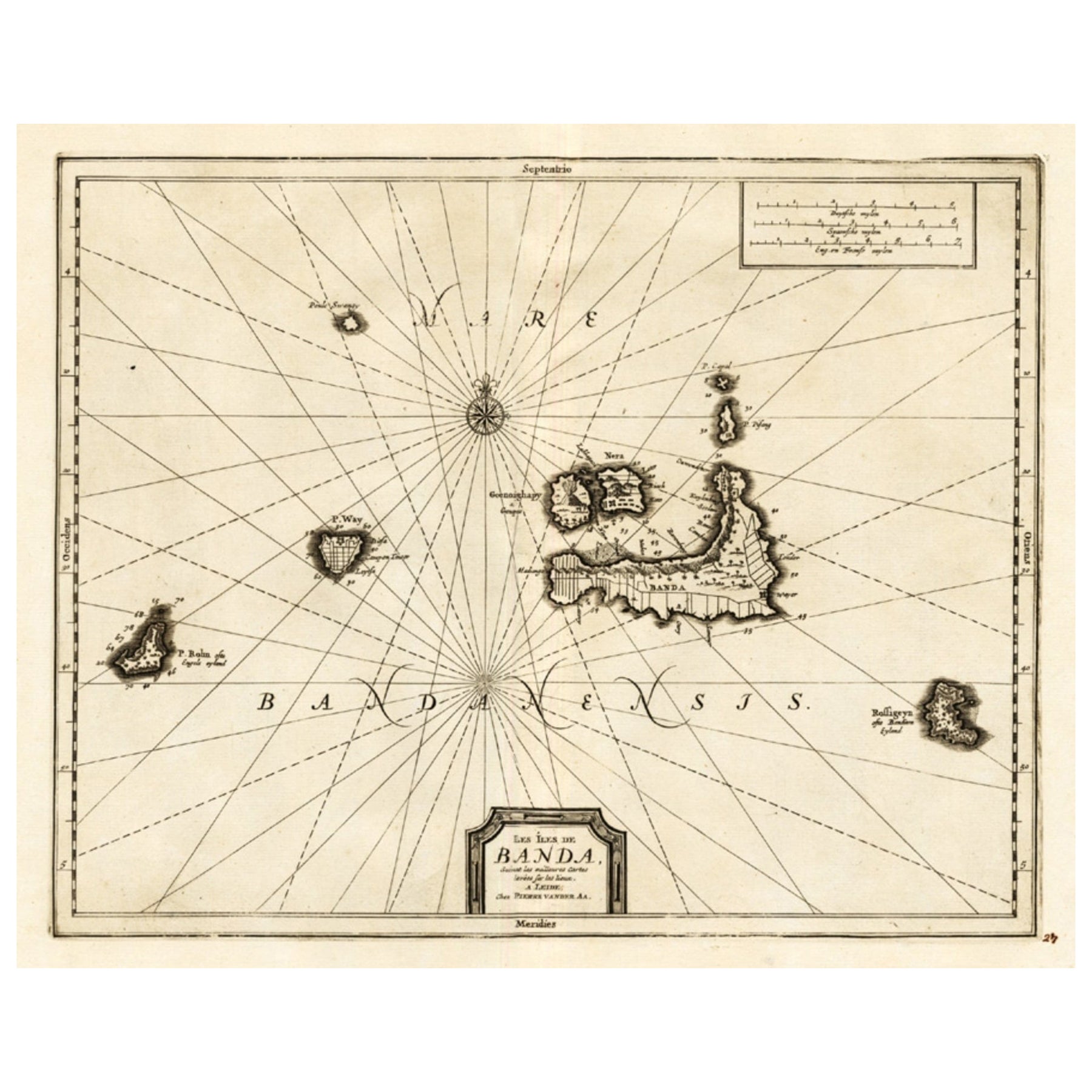
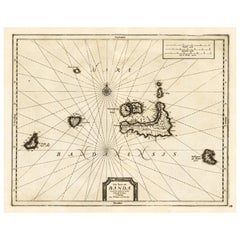
- Antique Map of the Islands of Banda, Indonesia from a Very Rare Edition, 1725Located in Langweer, NLAntique map titled 'Les Iles de Banda (..).' (The islands of Banda, Indonesia.) Extremely rare in this edition. This plate originates from the very scarse: 'La galerie agreable d...Category
Antique 1720s Maps
MaterialsPaper
- Antique Map of the Russian Empire in Europe, ca.1780Located in Langweer, NLDescription: Antique map titled 'Bowles's New Pocket Map of the Russian Empire in Europe, Comprehending the West Part of the Empire in Asia' Large and detai...Category
Antique 1780s Maps
MaterialsPaper
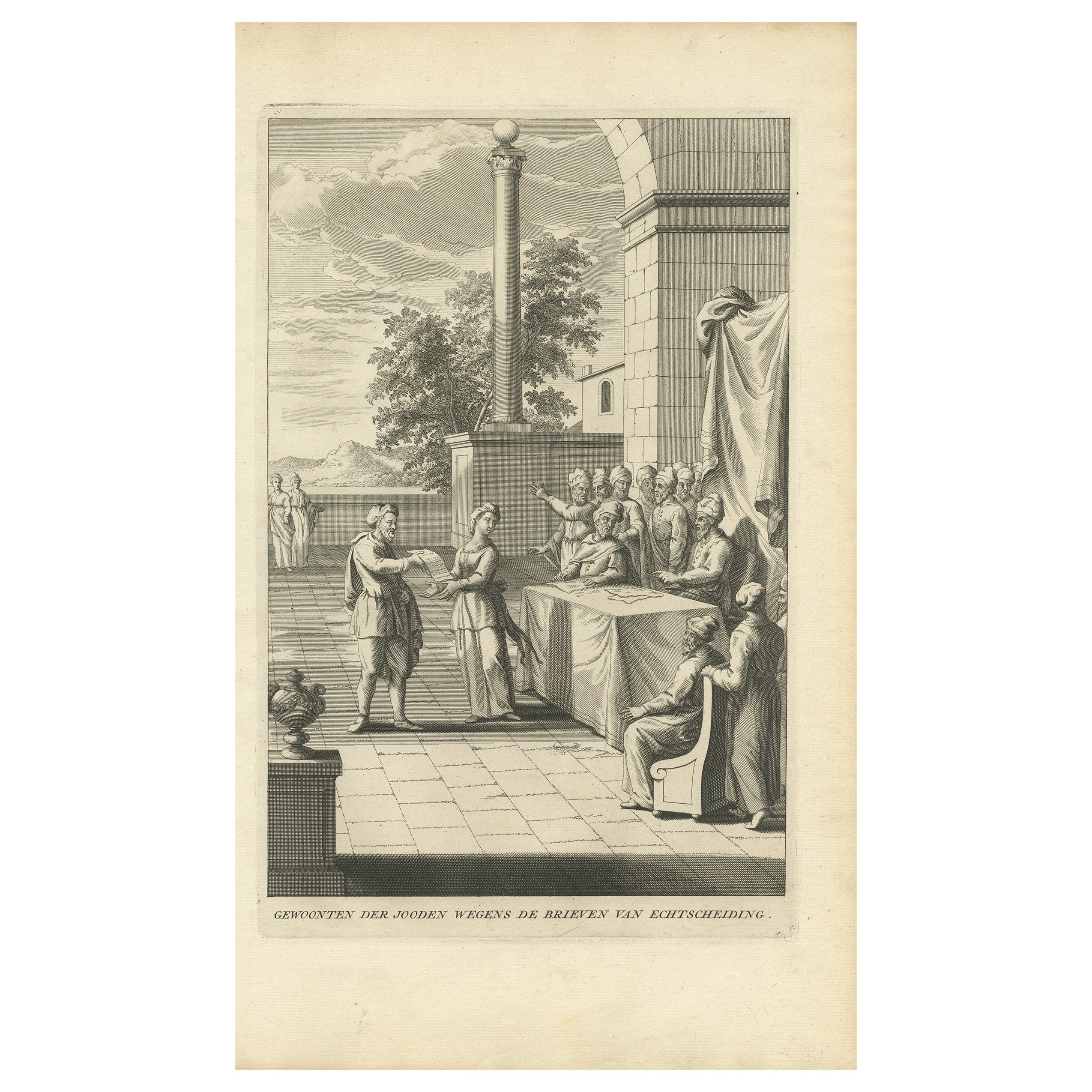
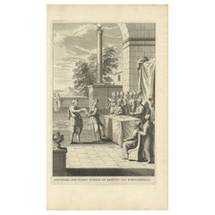
- Antique Print Depicting the Divorce Customs of the Jews, ca.1725Located in Langweer, NLDescription: Antique religion print titled 'Gewoonten der Jooden wegens de brieven van Echtscheiding'. This print depicts divorce customs of the Jews. This print originates from ...Category
Antique 1720s Prints
MaterialsPaper
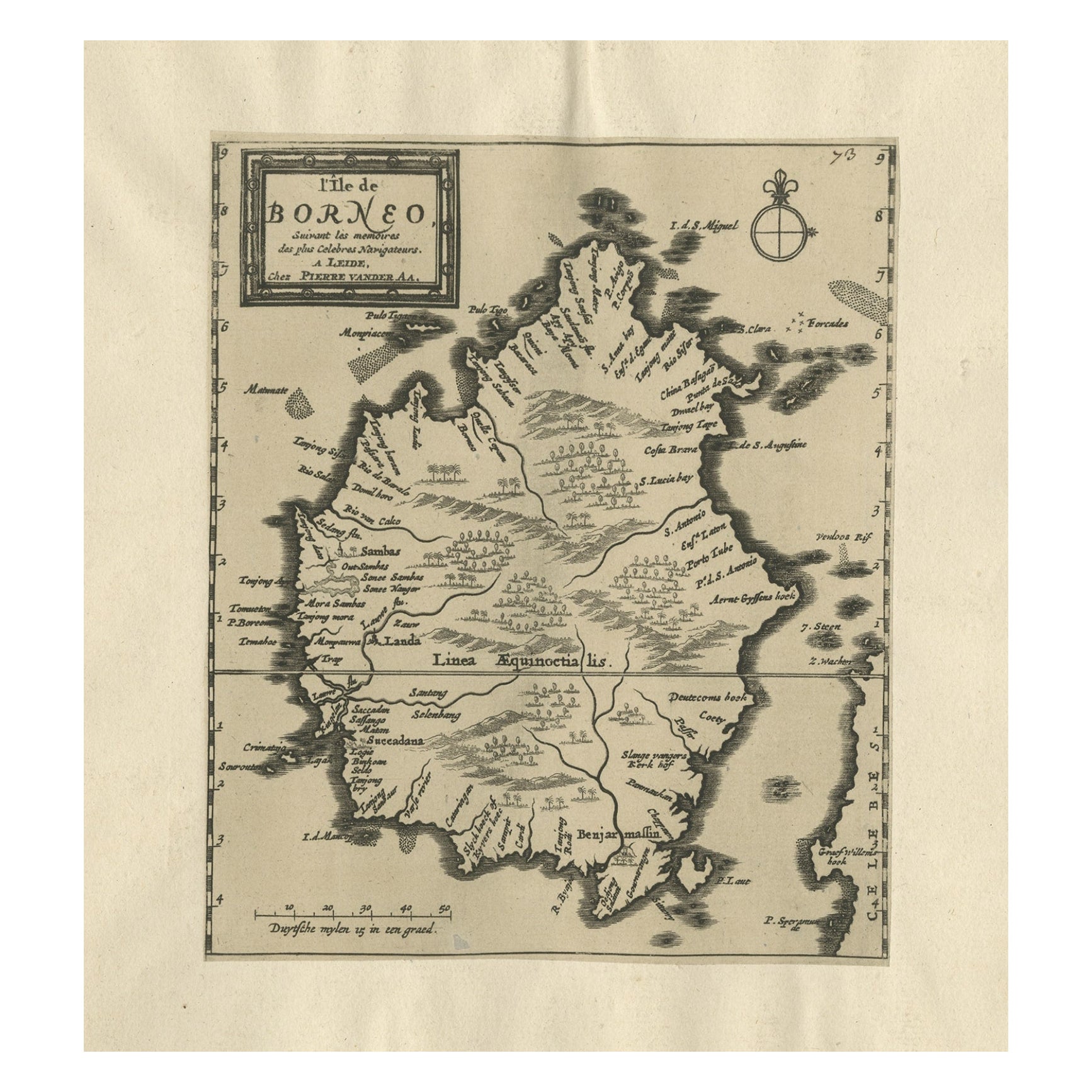
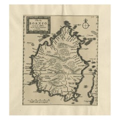
- Extremely Scarce Antique Map of The Island of Borneo, Indonesia, c. 1725Located in Langweer, NLAntique map titled 'L'Ile de Borneo Suivant les memoires des plus Celebres Navigateurs.' A detailed map of the island Borneo, with a small part of Celebes visible. This plate origi...Category
Antique 18th Century Maps
MaterialsPaper


You May Also Like
- Map of the Republic of GenoaLocated in New York, NYFramed antique hand-coloured map of the Republic of Genoa including the duchies of Mantua, Modena, and Parma. Europe, late 18th century. Dimension: 25...Category
Antique Late 18th Century European Maps
- Original Antique Map of The World by Thomas Clerk, 1817Located in St Annes, LancashireGreat map of The Eastern and Western Hemispheres On 2 sheets Copper-plate engraving Drawn and engraved by Thomas Clerk, Edinburgh. Published by Mackenzie And Dent, 1817 ...Category
Antique 1810s English Maps
MaterialsPaper
- Antique Map of Principality of MonacoBy Antonio Vallardi EditoreLocated in Alessandria, PiemonteST/619 - "Old Geographical Atlas of Italy - Topographic map of ex-Principality of Monaco" - ediz Vallardi - Milano - A somewhat special edition ---Category
Antique Late 19th Century Italian Other Prints
MaterialsPaper
- Original Antique Map of The Netherlands, Engraved by Barlow, Dated 1807Located in St Annes, LancashireGreat map of Netherlands Copper-plate engraving by Barlow Published by Brightly & Kinnersly, Bungay, Suffolk. Dated 1807 Unframed.Category
Antique Early 1800s English Maps
MaterialsPaper
- Antique 18th Century Map of the Province of Pensilvania 'Pennsylvania State'Located in Philadelphia, PAA fine antique of the colony of Pennsylvania. Noted at the top of the sheet as a 'Map of the province of Pensilvania'. This undated and anonymous map is thought to be from the Gentleman's Magazine, London, circa 1775, although the general appearance could date it to the 1760's. The southern boundary reflects the Mason-Dixon survey (1768), the western boundary is placed just west of Pittsburgh, and the northern boundary is not marked. The map has a number of reference points that likely refer to companion text and appear to be connected to boundaries. The western and southern boundaries are marked Q, R, S, for example. A diagonal line runs from the Susquehanna R to the Lake Erie P. A broken line marked by many letters A, B, N, O, etc., appears in the east. There are no latitude or longitude markings, blank verso. Framed in a shaped contemporary gilt wooden frame and matted under a cream colored matte. Bearing an old Graham Arader Gallery...Category
Antique 18th Century British American Colonial Maps
MaterialsPaper
- Map "Estuary- Mouth of the Thames"Located in Alessandria, PiemonteST/426 - Antique French Map of the estuary of the Thames, map dated 1769 - "Mape of the entrance of the Thames. Designed by filing of Navy cards fo...Category
Antique Mid-18th Century French Other Prints
MaterialsPaper


Recently Viewed
View AllMore Ways To Browse
For The Empire
Extremely Rare Collectible
American Empire Antiques
Antique Doors India
Oriental Door
Book Of Antique Maps
Pakistan Antiques
Antique Pakistani
Antique Map Border
Dutch Empire
Empire Antiques Plate
Oriental Antiques Collectables
Antique Oriental Plate
Antique Oriental Plates
Antique India Map
India Antique Map
Antique Maps India
Antique Map India