Empire Maps

EMPIRE STYLE

From 1804–15, Napoléon I reigned as the emperor of France, bringing the country into a new era of opulence after the fall of the monarchy and the tumultuous years of the French Revolution. He declared, “We must have very solid things, made to last 100 years.” Empire-style furniture followed suit, with imposing pieces constructed from mahogany and adorned with gilded ornaments. Expanding on the neoclassicism popularized in the previous century — such as in ​​Louis XVI style — Empire style borrowed from the great civilizations of antiquity, from Egypt to Greece and Rome, to connect this nascent empire to the power of the past.

Napoléon I believed the production of fine furniture would reflect the stature of the republic, with his official architects Charles Percier and Pierre-François-Léonard Fontaine leading the way with their work on his residences.

Luxurious materials, symmetrical shapes and bold colors characterize antique Empire-style bedroom furniture, armchairs, cabinets and other structures, with frequent motifs including mythological creatures, geometric designs, acanthus leaves, eagles, bees (the imperial emblem) and swans, a favorite of Empress Joséphine.

Flat surfaces, like marble tabletops, were accented with decadent details, such as the bronze furniture mounts made by sculptor Pierre-Philippe Thomire for the French palaces. Martin-Guillaume Biennais, who worked as the imperial goldsmith, crafted intricate luxury objects that mixed wood, fine metal, mother-of-pearl and ivory. Ormolu — or elaborate bronze gilding — was essential to French design in the 18th and 19th centuries as a cornerstone of the neoclassical and Empire styles.

The style became popular abroad, influencing the American Empire style. Stately pieces carved with sprigs of olives by cabinetmaker Pierre-Antoine Bellange were acquired by American President James Monroe for the White House in 1817.

Find a collection of antique Empire tables, lighting, seating and other furniture on 1stDibs.

1
to
1
1
1
1
48
34
15
9
7
6
5
4
4
2
1
1
1
1
1
1
1
1
Style: Empire
Ptolemaic Armillary Sphere Charles-François Delamarche Paris, 1805-1810 Circa
Located in Milano, IT
Charles-François Delamarche Ptolemaic armillary sphere Paris, circa 1805-1810 Wood and papier-mâché covered with printed and partly hand-coloured paper It measures 15.74” in height, ...
Category

Early 1800s French Antique Empire Maps

Materials

Paper, Wood

Related Items
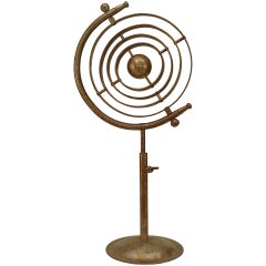
Italian Renaissance Chrome Armillary
Located in New York, NY
Italian Renaissance-style (20th Century) chrome armillary globe with a rust patina.
Category

20th Century American Empire Maps

Materials

Chrome

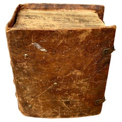
Antique Swedish Leather-Bound Bible Book, 1810
Located in Haddonfield, NJ
Swedish leather-bound Bible, with brass brackets decorated with two hearts and two anchors. According to the estate in Sweden where I purchased this book, it belonged to a Scandinavi...
Category

1810s Swedish Antique Empire Maps

Materials

Brass

Painted Dolls House, England circa 1810
Located in Culver City, CA
Painted Dolls House England circa 1810 Georgian era dolls house with original paintwork. 19.5”L x 11.25”d x 17.75”h
Category

19th Century English Antique Empire Maps

Materials

Wood

Painted Dolls House, England circa 1810
H 17.75 in W 19.5 in D 11.25 in
French Late 19th Century Bronze Armillary Sphere Depicting the Titan Atlas
Located in Atlanta, GA
A French bronze armillary sphere depicting Atlas carrying the world from the late 19th century with verdigris patina. Created in France during the last quarter of the 19th century, this bronze armillary sphere showcases a mythological theme depicting the famed Titan Atlas, condemned to carry the sky on his shoulders for eternity. How appropriate then, to choose him to carry effortlessly this armillary! Casually placing his left hand on his waist, Atlas raises the sphere made of various connecting rings...
Category

Late 19th Century French Antique Empire Maps

Materials

Bronze

Impressive and Ancient Italian Armillary Sphere from Early 20th Century
Located in Madrid, ES
Impressive and Ancient Italian Armillary Sphere from early 20th century, handcrafted in wood and metal/golden brass with a base on 3 solid wood legs. Certificate of authenticity....
Category

Early 20th Century Italian Empire Maps

Materials

Iron

Pair of Italian Armillary Spheres Vane began 20th Century H: 80cm
Located in Madrid, ES
Pair of Italian Armillary Spheres Vane began 20th Century material: iron and stone HEIGHT 80 cm DIAMETER 60 cm WIDTH 60 cm DEPTH 85 cm good conditions
Category

Early 20th Century Italian Empire Maps

Materials

Stone, Iron

Antique Map of Southern Europe by F. Delamarche, 1837
Located in Langweer, NL
Title: Géographie des Hébreux ou Tableau de la Dispersion des enfants de Noé - **Origin**: From 'Atlas De La Géographie Ancienne' by F. Delamarche - **Date of Publication**: 1837 D...
Category

Mid-19th Century Antique Empire Maps

Materials

Paper

Antique Map of the Holy Land by Delamarche, 1806
Located in Langweer, NL
Antique map titled 'Judee ou Terre Sainte sous les Turcs.' This map shows the holy land under the Turcs. By Robert de Vaugondy, revised and published by ...
Category

19th Century Antique Empire Maps

Materials

Paper

Exploring Ancient Persia: Ptolemaic Map of Iran and Iraq by Ptolemy and Mercator
Located in Langweer, NL
Claudius Ptolemy was a mathematician, astronomer and geographer who worked in Alexandria, then a part of the Roman Empire, in the 2nd century AD. One of the most learned and influent...
Category

1610s Antique Empire Maps

Materials

Paper

Exclusive Antique Armillary Sphere
Located in Vlimmeren, BE
An armillary sphere is a model of objects in the sky consisting of a spherical framework of rings, centred on the Earth or the Sun, that represent lin...
Category

Mid-19th Century European Antique Empire Maps

Materials

Metal

Mercator's Ptolemaic Map of the Holy Land, Cyprus and Syria, circa 1580
Located in Langweer, NL
Antique map titled 'Asiae IIII Tab'. Beautiful map of Mercator's Ptolemaic map of the Holy Land, Cyprus, Syria, etc. Originates from Mercator's 'Geographia'. Gerard Mercator (1512 ...
Category

16th Century Antique Empire Maps

Materials

Paper

Antique Map of Africa by Delamarche, 1806
Located in Langweer, NL
Antique map titled 'L'Afrique'. Decorative map of Africa by Robert de Vaugondy, revised and published by Delamarche. Source unknown, to be determined. Artists and Engravers: Charl...
Category

19th Century Antique Empire Maps

Materials

Paper

Empire maps for sale on 1stDibs.

Find a broad range of unique Empire maps for sale on 1stDibs. Many of these items were first offered in the 19th Century, but contemporary artisans have continued to produce works inspired by this style. If you’re looking to add vintage maps created in this style to your space, the works available on 1stDibs include more furniture and collectibles and other home furnishings, frequently crafted with paper, wood and other materials. If you’re shopping for used Empire maps made in a specific country, there are Europe, and France pieces for sale on 1stDibs. While there are many designers and brands associated with original maps, popular names associated with this style include and Charles Francois Delamarche. It’s true that these talented designers have at times inspired knockoffs, but our experienced specialists have partnered with only top vetted sellers to offer authentic pieces that come with a buyer protection guarantee. Prices for maps differ depending upon multiple factors, including designer, materials, construction methods, condition and provenance. On 1stDibs, the price for these items starts at $9,685 and tops out at $9,685 while the average work can sell for $9,685.

Recently Viewed

View All