Want more images or videos?
Request additional images or videos from the seller
1 of 18
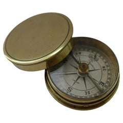
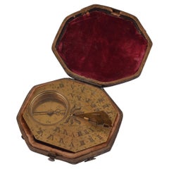
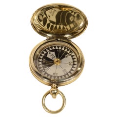
Sinclair Haymarket London Signature Liquid Sensing Pocket Compass
$1,050.95List Price
About the Item
- Dimensions:Height: 1 in (2.54 cm)Diameter: 2 in (5.08 cm)
- Materials and Techniques:
- Period:1910-1919
- Date of Manufacture:1918
- Condition:Wear consistent with age and use.
- Seller Location:Milan, IT
- Reference Number:1stDibs: LU1020236385192
About the Seller
5.0
Vetted Professional Seller
Every seller passes strict standards for authenticity and reliability
Established in 1999
1stDibs seller since 2014
398 sales on 1stDibs
Typical response time: 2 hours
Authenticity Guarantee
In the unlikely event there’s an issue with an item’s authenticity, contact us within 1 year for a full refund. DetailsMoney-Back Guarantee
If your item is not as described, is damaged in transit, or does not arrive, contact us within 7 days for a full refund. Details24-Hour Cancellation
You have a 24-hour grace period in which to reconsider your purchase, with no questions asked.Vetted Professional Sellers
Our world-class sellers must adhere to strict standards for service and quality, maintaining the integrity of our listings.Price-Match Guarantee
If you find that a seller listed the same item for a lower price elsewhere, we’ll match it.Trusted Global Delivery
Our best-in-class carrier network provides specialized shipping options worldwide, including custom delivery.You May Also Like
Fine Brass Cased Pocket Compass by Short & Mason Ltd., London c.1910
By Short & Mason
Located in Bath, GB
A very fine English brass cased compass, professionally cleaned and polished restoring it to it's former glory. The face signed Short & Mason / London together with the brand name "...
Category
Vintage 1910s British Edwardian Scientific Instruments
Materials
Brass
$331
Free Shipping
H 0.5 in Dm 1.5 in
Old Compass reproduction 1944 London, brown Color
Located in Auribeau sur Siagne, FR
Old Compass reproduction 1944 London, brown Color
Category
20th Century English Scientific Instruments
Materials
Metal
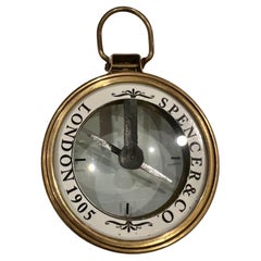
Antique English Brass & Glass Elegant Compass by Spencer & Co London
By Spencer & Company
Located in San Diego, CA
Beautiful elegant compass circa 1970's in solid brass with glass bt spencer & Co.
Category
20th Century English Hollywood Regency Aviation Objects
Materials
Brass
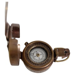
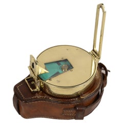
WWI British Military Pocket Compass of Brass with Original Leather Case
Located in Austin, TX
A working British marching or sighting compass of brass with original leather case from World War I - made for military and civilian use.
A handsome piece of militaria and a fine me...
Category
Vintage 1910s English Edwardian Historical Memorabilia
Materials
Metal, Brass
$495
H 2.13 in W 2 in D 0.57 in
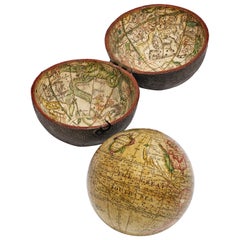
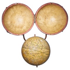
Pocket Globe by Nathaniel Hill, London 1754
Located in Milano, IT
Nathaniel Hill
Pocket globe
London, 1754
The globe is contained in its original case, which itself is covered in shark skin.
There are slight gaps in the original paint on the sphere. The case no longer closes.
The sphere measures 2.6 in (6.8 cm) in diameter whereas the case measures 2.9 in (7.4 cm) in diameter.
lb 0.24 (kg 0.11)
The globe is made up of twelve printed paper gores aligned and glued to the sphere.
In the North Pacific Ocean there is a scroll with the inscription:
A
New
terrestrial
Globe
by
Nath. Hill,
1754.
The celestial globe is depicted on the inside of the box.
On the terrestrial globe much of central and southern Africa is empty. North America bears only the name of some British colonies. It shows California as a peninsula and the northwest coast of America as "unknown parts" (Alaska is not described and is only partially delineated; it would become part of the United States in 1867). The route of Admiral Anson is traced (1740) and the trade winds are indicated by arrows. Australia, still named New Holland (the new name would be introduced in 1829), is part of the west coast. (See Van der Krogt, P., Old Globes in the Netherlands, Utrecht 1984, p. 146 and Van der Krogt, P. - Dekker, E., Globes from the Western World, London 1993, p. 115.)
Nathaniel Hill (London, news from 1746 to 1768) had impeccable professional credentials: he had done his apprenticeship with Richard Cushee, who at the time was carrying out surveying work for John Senex's Surrey map...
Category
Antique 1750s English George II Globes
Materials
Shagreen, Paper
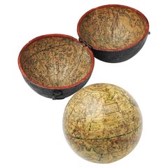
Pocket Globe, Nicholas Lane, London, post 1779
By Nicholas Lane
Located in Milano, IT
Pocket Globe
Nicholas Lane
London, post 1779
The globe is contained in its original case, which is covered in leather.
The sphere measures 2.75 in (6.9 cm) whereas the case measure...
Category
Antique 1780s English Other Models and Miniatures
Materials
Leather, Wood, Paper
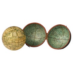
English Pocket Globe, London, Circa 1775-1798
By Herman Moll
Located in Milano, IT
Pocket globe
London, between 1775 and 1798
Re-edition of the globe of Hermann Moll (1678-1732) dated 1719
The globe is contained in its original case, which itself is covered in shark skin.
There are slight gaps in the original paint on the sphere. The case no longer closes.
The sphere measures 2.7 in (7 cm) in diameter whereas the case measures 2.9 in (7.4 cm) in diameter.
lb 0.22 (kg 0.1)
The globe is made up of twelve printed paper gores aligned and glued to the sphere.
In the North Pacific Ocean there is a cartouche with the inscription:
A Correct
Globe
with the new
Discoveries.
The celestial globe is depicted on the inside of the box and is divided into two hemispheres with the cartouche:
A correct globe
with ye new cons
relations of Dr.
Halley & c.
It shows the ecliptic divided into the days of the zodiacal calendar and the constellations represented as animals and mythological figures.
On the globe are delineated the equinoctial line, divided by degrees and hours, the ecliptic and the meridian (passing west of Greenwich). The continents are shaded and outlined in pink, green and yellow. It shows: the Cook routes; a wind rose in the Southern Indian Ocean; Antarctica without land; Africa with Negroland (Hermann Moll is considered the first geographer to name the West African region in his 1727 map. (Encyclopaedia Britannica, ed. 1902, under "States of Central Africa"); Tartary in Central Asia; the Mogul kingdom in northern India; in North America only New England, Virginia, Carolina, Florida, Mississippi are identified; California is already a peninsula; the northwest coast of America is "unknown parts" (Alaska is not described and it is only partially delineated, it was to become part of the United States in 1867); Mexico is named "Spain"; Central South America "Amazone America". Australia (which was to be so named after 1829) is called New Holland. The route of Admiral Anson is traced (1740) and the trade winds are indicated by arrows. (See Van der Krogt, P., Old Globes in the Netherlands, Utrecht 1984, p. 146 and Van der Krogt, P. - Dekker, E., Globes from the Western World, London 1993, pp. 115.)
Elly Dekker, comparing Moll’s 1719 globe and his re-edition (of which the one described above is a sample), identifies the differences between them: the two editions are quite similar to each other, but in the "anonymous" globe, compared to the previous globe of 1719, California looks like a proper peninsula - the reports of the Spanish explorers of the region had given rise to uncertainty over whether it was connected to the mainland or not. The geographical nature of California was confirmed after the explorations of Juan Bautista de Anza (1774-1776). The routes of Dampier's journey were partially erased and the route of Captain James Cook's first voyage was superimposed on them, and the geography of Australasia was adapted accordingly, including the denomination of the Cook Strait. See Dekker, Elly, Globes at Greenwich, 1999.
An important ante quem element is represented by Tasmania: it is not separated from Australia by the Bass Strait...
Category
Antique Late 18th Century English George III Globes
Materials
Shagreen, Paper
Compass with Pocket Sundial, with Case, Bronze, Butterfield, Michael '1635-1724'
Located in Madrid, ES
Compass with pocket sundial, with case. Bronze. BUTTERFIELD, Michael (1635-1724). Paris, circa 1700.
Pocket sundial made of engraved metal, with a gno...
Category
Antique Early 18th Century French Neoclassical Scientific Instruments
Materials
Metal, Bronze, Other
$4,079
H 2.96 in W 3.35 in D 0.79 in
Rare George III Celestial Pocket Globe by Cary, London
By Cary
Located in Oxfordshire, United Kingdom
A fine and rare 3" celestial pocket globe by G & W Cary, Strand, London circa 1791, housed in its original sharkskin case.
A companion globe to terrestrial globes of this type we...
Category
Antique Late 18th Century English George III Aviation Objects
Materials
Plaster
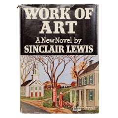
Work of Art by Sinclair Lewis
Located in valatie, NY
Work of Art by Sinclair Lewis. Doubleday, Doran & Co., 1935. "This is the story of Myron Weagle and of America. Myron wanted to create the perfect hotel, a work of art. He worked and dreamed his way from bell boy...
Category
Vintage 1930s American Books
Materials
Paper
More From This Seller
View AllCompass by hand magnetic sensing, signed Henry Browne & Son early 1900s
Located in Milan, IT
Compass by hand magnetic sensing, signed Henry Browne & Son Ltd Sestrel Made in England, No. 6162/B Barking & London early 1900s Height 25 cm - inches 9.8, compass diameter 10.5 ...
Category
Antique Early 1900s Nautical Objects
Materials
Brass
Traveler's pocket compass, Victorian-era turned brass
Located in Milan, IT
Traveler's pocket compass, Victorian-era turned brass, late 19th century England, rose on sixteen-twenty copperplate engraving paper complete with goniometric circle.
Conservation s...
Category
Antique 1890s Scientific Instruments
Materials
Brass
Official British aviation pocket compass signed E. KOEHN Geneva, 1915
Located in Milan, IT
British aviation officer's pocket compass signed E. KOEHN Geneva Switzerland V 1915 brass in the shape of an onion clock. The compass has a snap-lock cover with release button insid...
Category
Vintage 1910s Aviation Objects
Materials
Brass
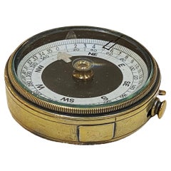
Nautical survey magnetic compass signed Elliott Bros London late 1800s
Located in Milan, IT
Rare magnetic nautical surveying compass, brass, late 19th century signed Elliott Bros London complete with leather case. This is a small compass, 7 cm diameter, typically used in re...
Category
Antique Late 19th Century Nautical Objects
Materials
Brass
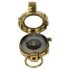
1917 Verner's Pattern brass prismatic surveying compass
Located in Milan, IT
Brass prismatic surveying compass; this is a small compass, Verner's Pattern named after the designer, Colonel William Willoughby Cole Verner (1852-1922) and produced in 1917 and su...
Category
Vintage 1910s Scientific Instruments
Materials
Brass
Wooden compass box with rosewood veneer circa 1870s
Located in Milan, IT
Box of compasses wood with rosewood veneer from the second mid-19th century, complete with key. In the center of the lid a rhombus-shaped brass medallion is engraved with the name...
Category
Antique 1870s Scientific Instruments
Materials
Brass
Recently Viewed
View AllMore Ways To Browse
Rosa Dei Venti
Antique Brass Gimbal
Antique Glass Floats
Antique Wood Pulleys
Boat Oars
Yacht Burgee
Antique Aquarium
Antique Ship Anchor Anchors
Boat Hull
Brass Ships Telegraph
Half Hull Models
Rosa Dei Venti
Scrimshaws
Antique Nautical Telescopes
Antique Ships Binnacle
Fishing Floats
Antique Half Hulls
Nautical Barometer