Items Similar to Antique Print of Hanseatic City of Lübeck in Northern Germany by Merian, c.1650


Want more images or videos?
Request additional images or videos from the seller
1 of 6
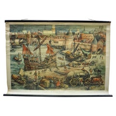
Antique Print of Hanseatic City of Lübeck in Northern Germany by Merian, c.1650
About the Item
Antique print titled 'Lubecca, Lübeck'. A bird's eye view of Lubeck, the northern German city in Schleswig-Holstein. This print originates from 'Topographia Saxoniae Inferioris'.
Artists and Engravers: Matthäus Merian der Ältere (or "Matthew", "the Elder", or "Sr."; 22 September 1593 – 19 June 1650) was a Swiss-born engraver who worked in Frankfurt for most of his career, where he also ran a publishing house. He was a member of the patrician Basel Merian family.
Condition: Good, age-related toning. Please study image carefully.
Date: c.1650
Overall size: 39 x 29.5 cm.
Image size: 37 x 20 cm.
Antique prints have long been appreciated for both their aesthetic and investment value. They were the product of engraved, etched or lithographed plates. These plates were handmade out of wood or metal, which required an incredible level of skill, patience and craftsmanship. Whether you have a house with Victorian furniture or more contemporary decor an old engraving can enhance your living space. We offer a wide range of authentic antique prints for any budget.
- Dimensions:Height: 11.62 in (29.5 cm)Width: 15.36 in (39 cm)Depth: 0 in (0.01 mm)
- Materials and Techniques:
- Period:
- Date of Manufacture:c.1650
- Condition:Condition: Good, age-related toning. Please study image carefully.
- Seller Location:Langweer, NL
- Reference Number:
About the Seller
5.0
Platinum Seller
These expertly vetted sellers are 1stDibs' most experienced sellers and are rated highest by our customers.
Established in 2009
1stDibs seller since 2017
1,933 sales on 1stDibs
Typical response time: <1 hour
- ShippingRetrieving quote...Ships From: Langweer, Netherlands
- Return PolicyA return for this item may be initiated within 14 days of delivery.
More From This SellerView All
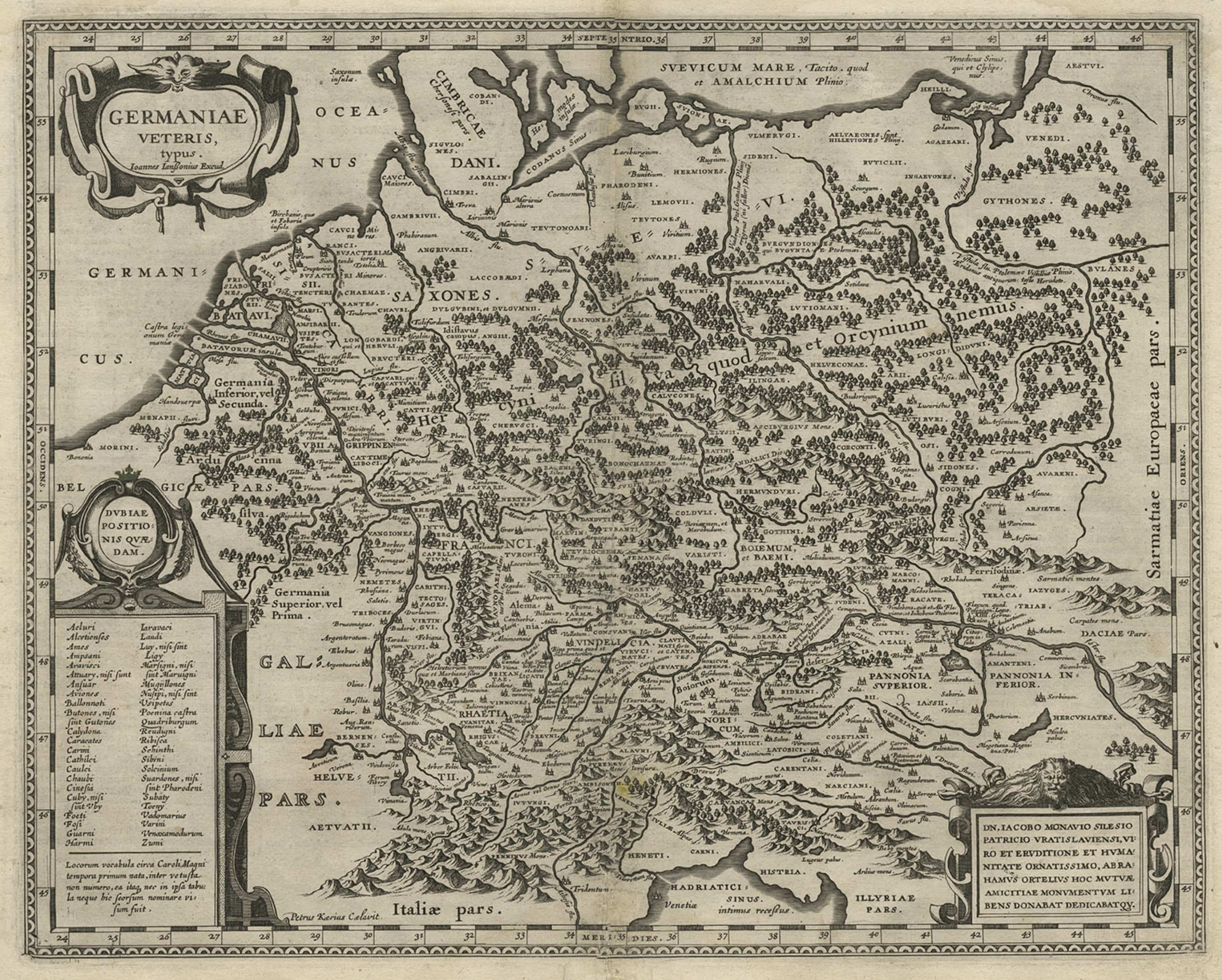
- Original Rare Antique Map of the Ancient German Empire in Northern Europe, c1650Located in Langweer, NLAntique map titled 'Germaniae Veteris typus.' Map of the ancient German Empire in Northern Europe, based upon an earlier map by Ortelius. Extends fr...Category
Antique 1650s Maps
MaterialsPaper
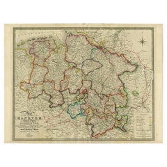
- Northern Germany incl Hanover, Oldenburg, Lippe, Bremen, Hamburg & Lubeck, 1854Located in Langweer, NLAntique map titled 'Map of the Kingdom of Hanover, with the Grand Duchy of Oldenburg, the principalities of Lippe Detmold and Schauenburg Lippe (..)'. Map of Northern Germany inc...Category
Antique 1850s Maps
MaterialsPaper
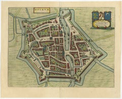
- Antique Map of the City of Dokkum, Friesland by Blaeu, c.1650Located in Langweer, NLAntique map titled ?Dockum?. Plan of Dokkum in Friesland, the Netherlands. A cartouche with two coats of arms. Originates from the town atlas 'Toneel der Steden', published by Joan Blaeu...Category
Antique 17th Century Maps
MaterialsPaper
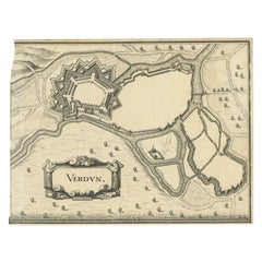
- Antique Map of the City of Verdun by Merian, c.1650Located in Langweer, NLAntique map titled 'Verdun'. Orginal antique map of Verdun, a small city in the Meuse department in Grand Est in northeastern France. This map originates from 'Topographia Germaniae'...Category
Antique 17th Century Maps
MaterialsPaper
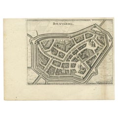
- Antique Map of the City of Bolsward by Merian, c.1650Located in Langweer, NLAntique map titled 'Bolzvardia'. Old map of the city of Bolsward, Friesland. This map was published with two other maps on one sheet (Hindeloopen and Stavoren). Artists and Engravers...Category
Antique 17th Century Maps
MaterialsPaper
- Antique Map of Northern Germany by M. Seutter, circa 1730By Matthew SeutterLocated in Langweer, NLAntique map titled 'Saxoniae Inferioris Circulus'. Old map of the northern part of Germany by M. Seutter. Covering the area of Lower Saxony, Mecklenburg-Vorpommern and Schleswig-Hols...Category
Antique Mid-18th Century Maps
MaterialsPaper

You May Also Like
- Harbour of a Trade City Hanseatic Port Rollable Vintage WallchartLocated in Berghuelen, DEThe maritime look vintage pull-down wall chart shows the historical picture of a port of an ancient trading city, published by Verlag Dr. te. Neues & Co., GmbH. Colorful print on pap...Category
Vintage 1970s German Country Prints
MaterialsCanvas, Wood, Paper
- City View of Nuremberg, Germany: An 18th Century Hand-Colored Map by M. SeutterBy Matthew SeutterLocated in Alamo, CAAn 18th century hand-colored city view of Nuremburg, Germany entitled "Geometrischer Grundris der des Heiligen Römischen Reichs Freyen Stadt Nürnberg" by Matthaus Seutter from his "A...Category
Antique Mid-18th Century German Maps
MaterialsPaper
- Original Antique Map / City Plan of Brussels by Tallis, circa 1850Located in St Annes, LancashireGreat map of Brussels. Steel engraving. Published by London Printing & Publishing Co. (Formerly Tallis), C.1850 Free shipping.Category
Antique 1850s English Maps
MaterialsPaper
- Antique Shooting Print by Archibald ThorburnBy Archibald ThorburnLocated in Oxfordshire, GBPartridge shooting picture by Archibald Thorburn. A game bird photogravure titled 'Coming Over The Guns (Partridge Driving)' by Archibald Thorburn. The partridge shooting picture is...Category
Antique Early 1900s English Sporting Art Sports Equipment and Memorabilia
MaterialsPaper
- Antique Cricket Print of Joseph Guy of NottinghamLocated in Oxfordshire, GBCricket print of Joseph Guy of Nottingham. A framed, tinted and hand colored lithographic portrait of the All- England cricketer Joseph Guy (1813 - 187...Category
Antique 1850s British Sporting Art Sports Equipment and Memorabilia
MaterialsPaper
- 17th Century Hand-Colored Map of a Region in West Germany by JanssoniusBy Johannes JanssoniusLocated in Alamo, CAThis attractive highly detailed 17th century original hand-colored map is entitled "Archiepiscopatus Maghdeburgensis et Anhaltinus Ducatus cum terris adjacentibus". It was published ...Category
Antique Mid-17th Century Dutch Maps
MaterialsPaper


Recently Viewed
View AllMore Ways To Browse
17th Decor
German Wood Birds
Antique Sr
17th Century German Engravings
Antique Merian Prints
Merian Engraving
Schleswig Holstein
French Glass Front Cabinet
18th Century Styled Chests
Italian Commode Pair
Metal Platform
Chinese Painted Wood Panel
Side Cabinet Blue
Antique Italian Carved Walnut
Antique French Carved Wood Cabinet
Vintage Pair Of Doors
Victorian Slider
Victorian Slide