Items Similar to Bird’s-Eye View of Genoa – Engraving by Matthäus Merian the Elder c.1650
Video Loading
Want more images or videos?
Request additional images or videos from the seller
1 of 13
Bird’s-Eye View of Genoa – Engraving by Matthäus Merian the Elder c.1650
$761.05
$951.3120% Off
£563.08
£703.8520% Off
€632
€79020% Off
CA$1,052.28
CA$1,315.3520% Off
A$1,155.27
A$1,444.0920% Off
CHF 602.71
CHF 753.3920% Off
MX$13,980.42
MX$17,475.5220% Off
NOK 7,554.02
NOK 9,442.5220% Off
SEK 7,117.87
SEK 8,897.3420% Off
DKK 4,812.07
DKK 6,015.0820% Off
About the Item
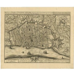
Bird’s-Eye View of Genoa – Engraving by Matthäus Merian the Elder c.1650
This finely detailed antique print titled Genua presents a sweeping bird’s-eye view of the historic Italian port city of Genoa, as seen from the sea. The composition is rich with intricately rendered buildings, fortified walls, churches, and bustling harbor scenes. Numerous ships of various sizes animate the foreground, emphasizing the city’s maritime importance and trading prowess during the 17th century.
Published circa 1650, this engraving was created by Matthäus Merian the Elder (1593–1650), a master Swiss engraver and publisher based in Frankfurt. Merian is best known for his Topographia series—a monumental collection of town views and maps documenting cities and regions across Europe. His works are celebrated for their precision, clarity, and artistic merit, offering some of the most accurate and elegant urban views of the period.
Genoa, at the time of this print, was a powerful maritime republic with significant influence in Mediterranean trade, banking, and naval affairs. This engraving not only captures the city’s imposing defenses and architectural complexity but also serves as a visual tribute to its wealth and strategic coastal setting. The title cartouche with a coat of arms at the top center and the extensive numbered key at the bottom provide informative reference points to notable landmarks and structures within the city.
Condition report: Excellent early impression with strong plate lines and sharp detail. Very light toning and minor edge wear consistent with age. The paper is in stable condition, and the overall presentation is crisp and historically compelling.
Framing tips: Ideal for a classic walnut, dark oak, or black frame with a light ivory or antique-white mount to complement the monochrome engraving. A museum-glass option will help preserve its detail and value.
- Dimensions:Height: 12.52 in (31.8 cm)Width: 16.62 in (42.2 cm)Depth: 0.02 in (0.5 mm)
- Materials and Techniques:Paper,Engraved
- Place of Origin:
- Period:Mid-17th Century
- Date of Manufacture:c.1650
- Condition:Repaired: Closed tear in left margin. Excellent early impression with strong plate lines and sharp detail. Very light toning and minor edge wear consistent with age. The paper is in stable condition, and the overall presentation is crisp and historically compelling.
- Seller Location:Langweer, NL
- Reference Number:Seller: BG-135861stDibs: LU3054336155162
About the Seller
5.0
Recognized Seller
These prestigious sellers are industry leaders and represent the highest echelon for item quality and design.
Platinum Seller
Premium sellers with a 4.7+ rating and 24-hour response times
Established in 2009
1stDibs seller since 2017
2,641 sales on 1stDibs
Typical response time: <1 hour
- ShippingRetrieving quote...Shipping from: Langweer, Netherlands
- Return Policy
Authenticity Guarantee
In the unlikely event there’s an issue with an item’s authenticity, contact us within 1 year for a full refund. DetailsMoney-Back Guarantee
If your item is not as described, is damaged in transit, or does not arrive, contact us within 7 days for a full refund. Details24-Hour Cancellation
You have a 24-hour grace period in which to reconsider your purchase, with no questions asked.Vetted Professional Sellers
Our world-class sellers must adhere to strict standards for service and quality, maintaining the integrity of our listings.Price-Match Guarantee
If you find that a seller listed the same item for a lower price elsewhere, we’ll match it.Trusted Global Delivery
Our best-in-class carrier network provides specialized shipping options worldwide, including custom delivery.More From This Seller
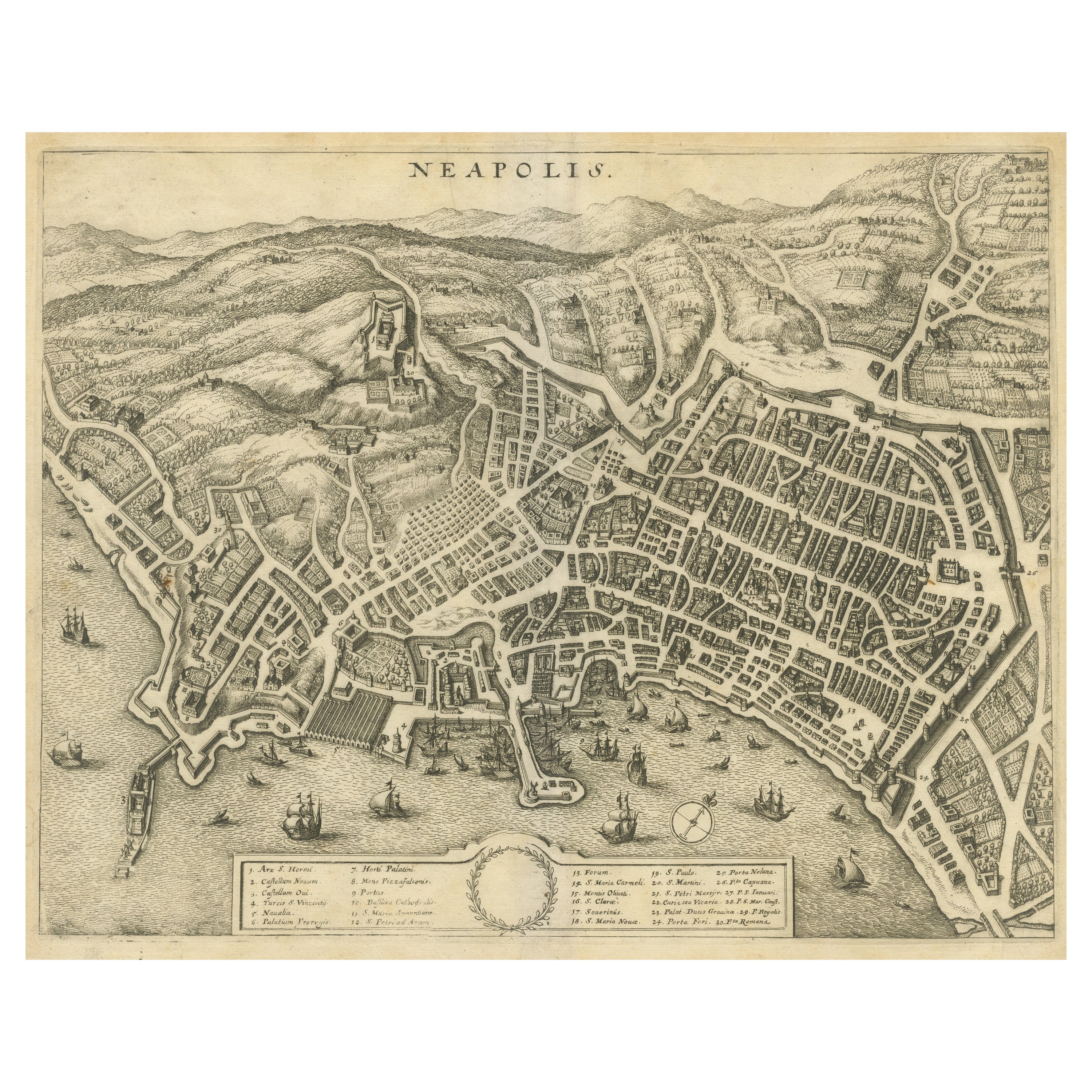
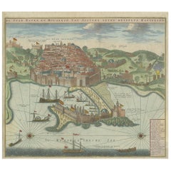
View AllBird’s-Eye View of Naples – Engraving by Matthäus Merian the Elder c.1650
Located in Langweer, NL
Bird’s-Eye View of Naples – Engraving by Matthäus Merian the Elder c.1650
This antique print titled Neapolis offers a remarkable bird’s-eye perspective of Naples, Italy, as it appea...
Category
Antique 1650s Prints
Materials
Paper
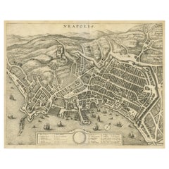
$761 Sale Price
20% Off
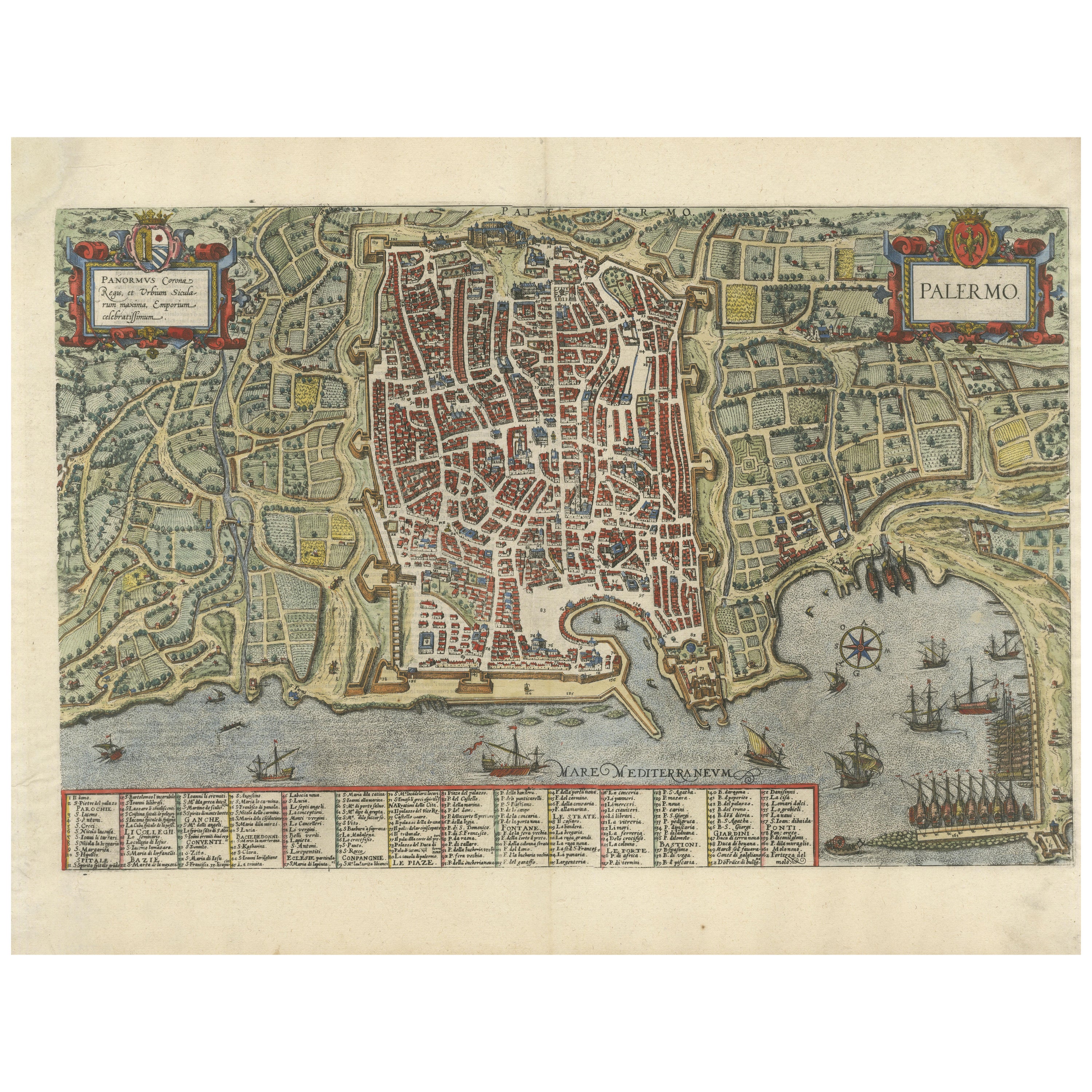
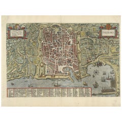
Palermo – 1620 Braun & Hogenberg Bird’s-Eye Map of Palermo, Sicily
Located in Langweer, NL
Palermo – 1620 Braun & Hogenberg Bird’s-Eye Map of Palermo, Sicily
This beautifully detailed bird’s-eye view of Palermo, Sicily, was created by Georg Braun and Frans Hogenberg aro...
Category
Antique 1620s Maps
Materials
Paper
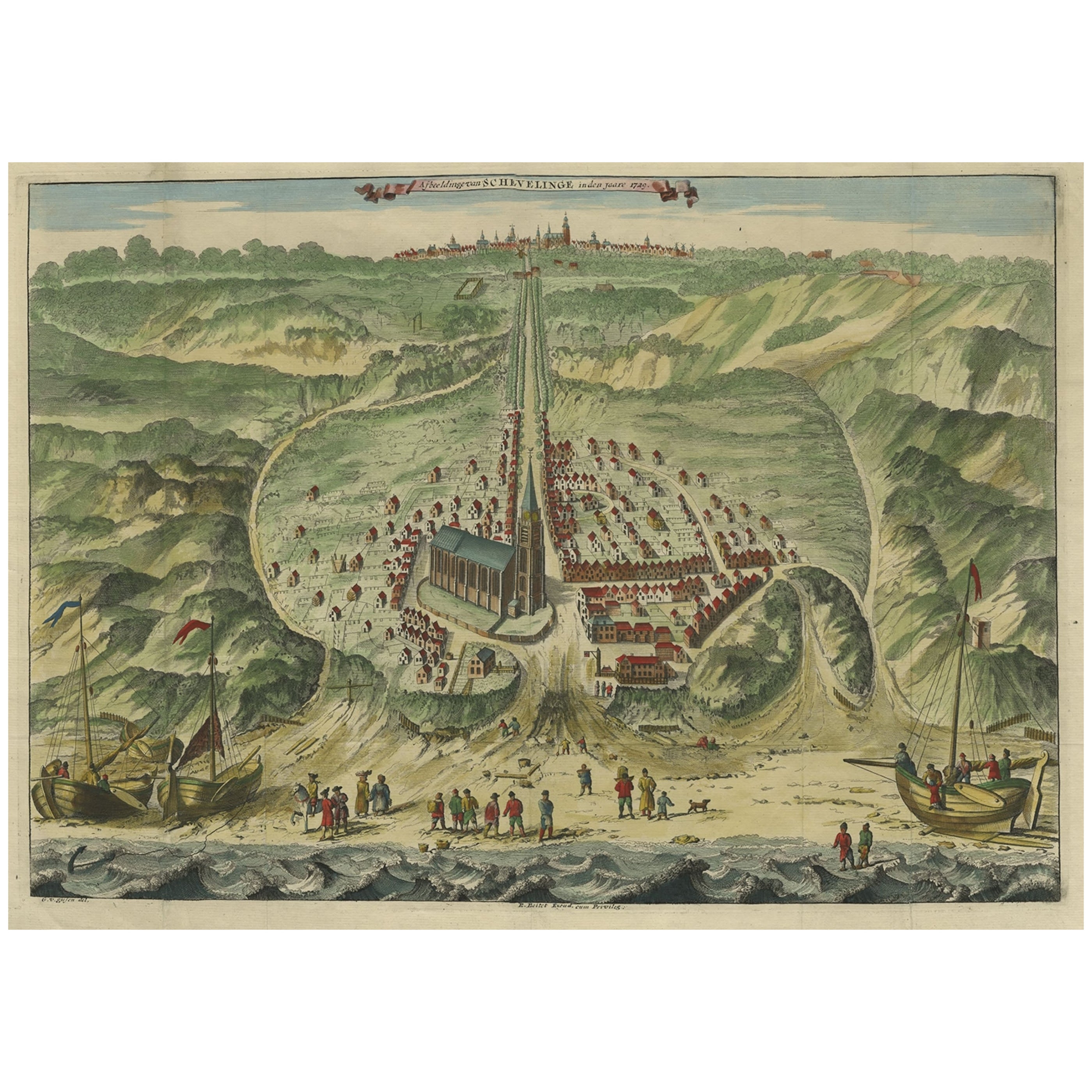
Antique Bird's Eye View of Scheveningen Near The Hague, the Netherlands, 1730
Located in Langweer, NL
Antique print titled 'Afbeeldinge van Schevelinge in den Jaare 1729'.
Bird's eye view of Scheveningen near The Hague / Den Haag, the Netherlands. This print originates from 'Beschr...
Category
Antique 1730s Maps
Materials
Paper

$1,300 Sale Price
20% Off
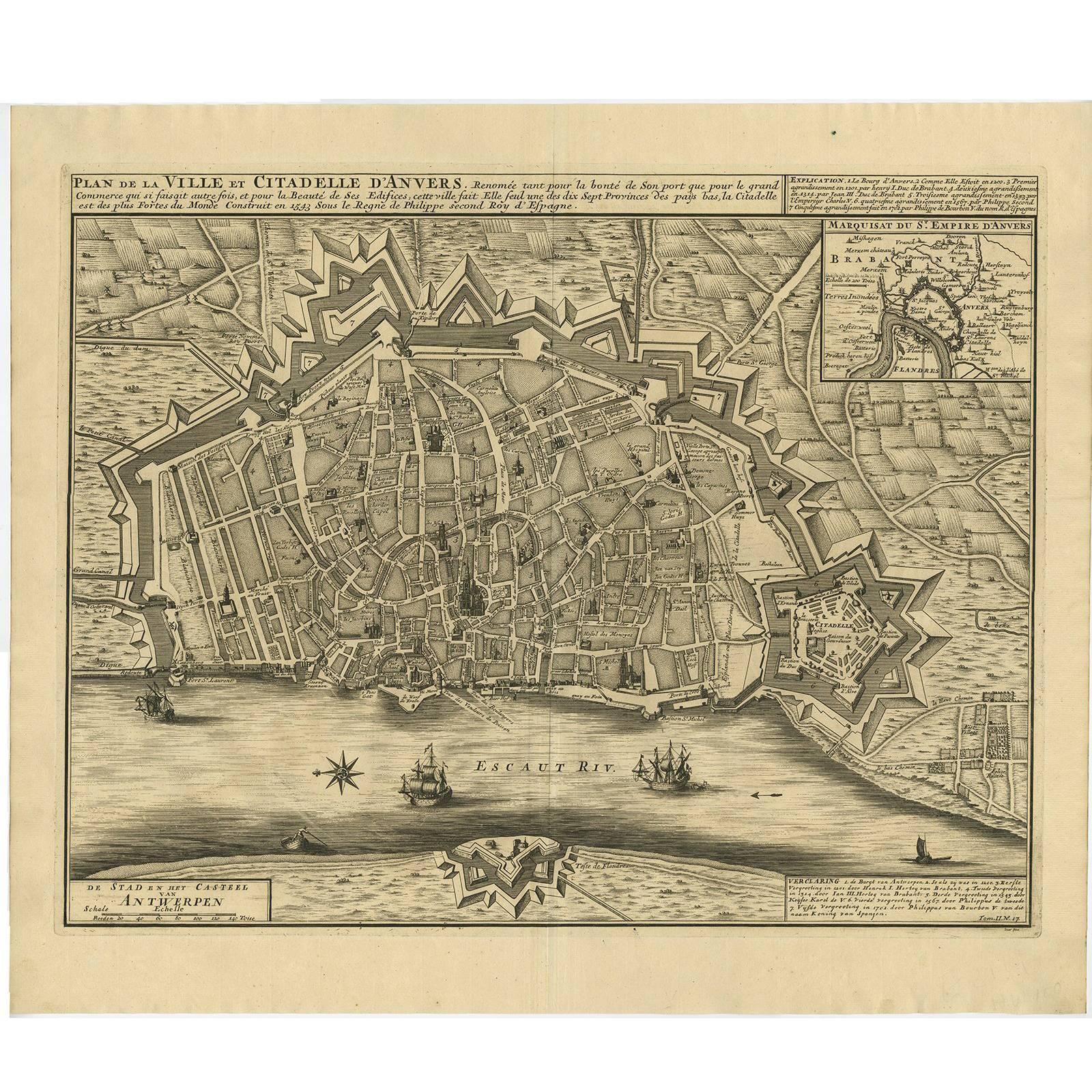
Antique Map of the City of Antwerpen ‘Belgium’ by A. Deur, 1729
Located in Langweer, NL
Copper-engraving by A. Deur. Published by I. van der Kloot in Den Haag, 1729. With French and Dutch title-cartouches and explanatory notes, several ships o...
Category
Antique Early 18th Century Maps
Materials
Paper
$741 Sale Price
20% Off
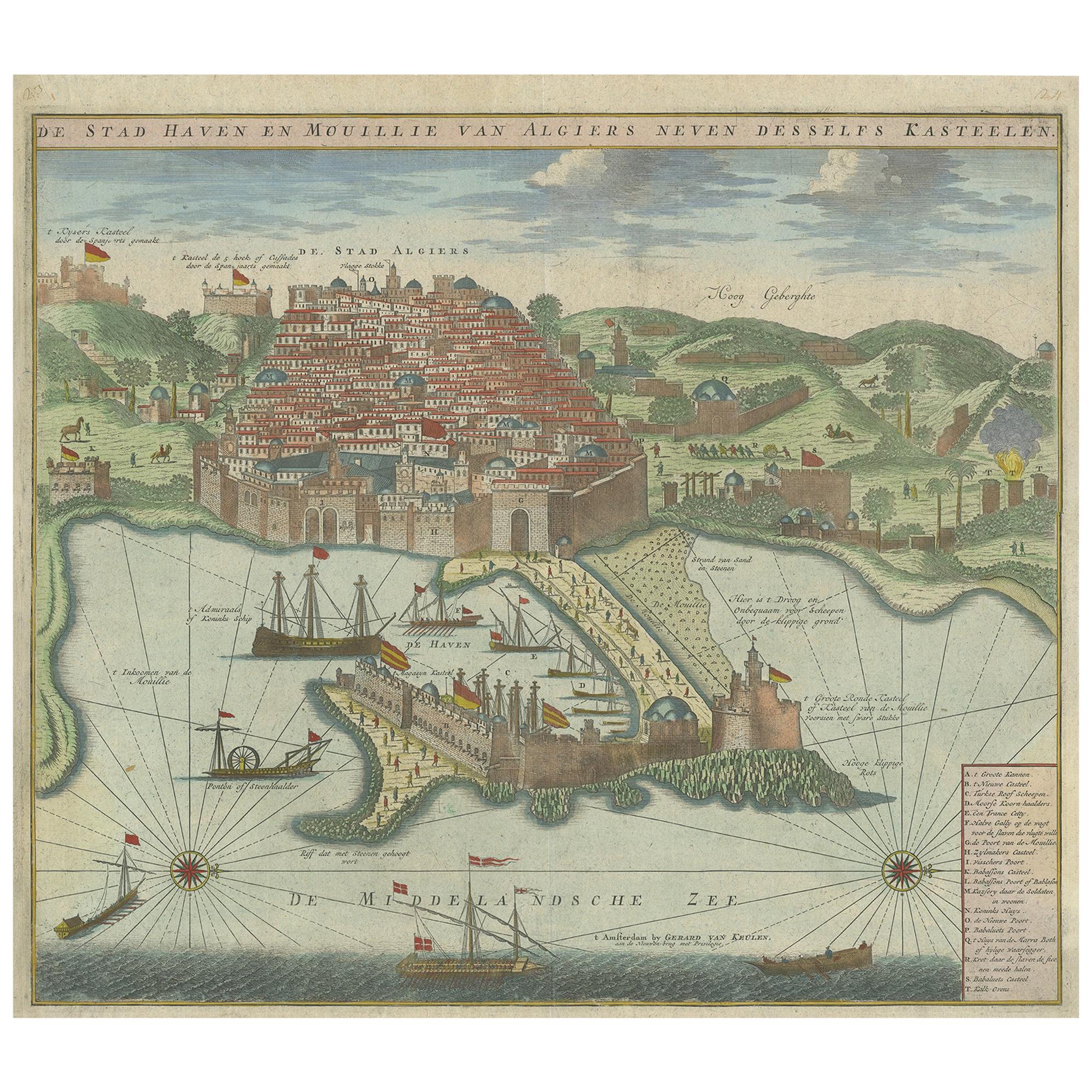
Antique Print of the Port and City of Algiers by Van Keulen, circa 1720
Located in Langweer, NL
Antique print titled 'De Stad Haven en Mouillie van Algiers neven desselfs Kastelen'. Rare double-page bird's-eye view of the port and city of Algiers. With detailed key in the lower right corner. Published by G. van Keulen...
Category
Antique Early 18th Century Dutch Prints
Materials
Paper
$1,354 Sale Price
25% Off
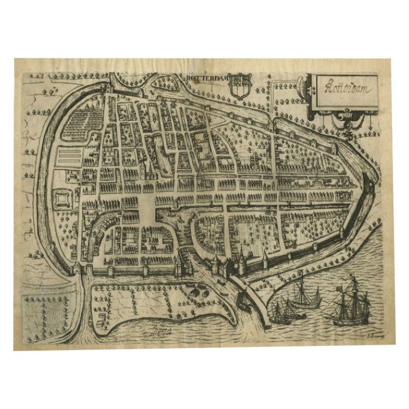
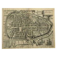
Antique Map of the City of Rotterdam by Guicciardini, C.1600
Located in Langweer, NL
Antique map titled 'Rotterdam'. Bird's eye view plan of Rotterdam in the province of Zuid-Holland, The Netherlands, Holland. This map originates from one of the editions of 'Discritt...
Category
Antique 17th Century Maps
Materials
Paper
$380 Sale Price
20% Off
You May Also Like
1597 German Map of Alexandria by Georg Braun and Frans Hogenberg
By Georg Braun and Frans Hogenberg
Located in Chapel Hill, NC
1597 Map of Alexandria by Georg Braun and Frans Hogenberg, Germany. From "Civitas Orbis Terrarum", part 2, published in Cologne by Bertram Buchholz. Printed in 2 parts. Title: "Alexa...
Category
Antique 16th Century German Renaissance Maps
Materials
Paper

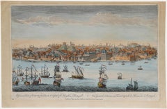
Laurie and Whittle - 1794 Engraving, A General View of the City of Lisbon
Located in Corsham, GB
A vibrant and captivating print depicting an expansive view of Lisbon, with ships sailing in the foreground. Inscribed within the plate below the image. On paper.
Category
Early 18th Century Landscape Prints
Materials
Engraving
18th Century Map Engraving - Plan of the Works of the City of Messina, Sicily
Located in Corsham, GB
A map of Messina, a harbour city in northeast Sicily. Inscribed with the title in plate to the lower edge, 'Plan of the Works of the City of Messina, one of the strongest and most co...
Category
18th Century More Prints
Materials
Engraving

$285 Sale Price
20% Off
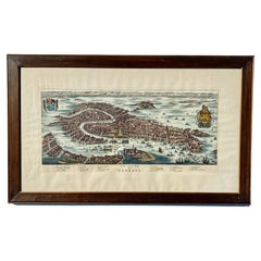
Vintage Italian Print Map of Venice in Freijo Wood Frame with Rosettes
Located in Miami, FL
Vintage Italian Print Map of Venice in Freijo Wood Frame with Rosettes
Offered for sale is a print of the Venetian map of 16th-century Venice. ...
Category
20th Century Prints
Materials
Wood, Paper
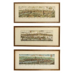
A Series of Historical Maps of Italian Cities
Located in New York, NY
A Pair of vintage maps can add so much interest to a space and this group of Italian maps is particularly interesting. Each is a charming reinterpretation of historical city maps (R...
Category
20th Century Italian Prints
Materials
Paper
$1,260 / item
18th Century French Map and City View of Joppe/Jaffa (Tel Aviv) by Sanson
By Nicholas Sanson d'Abbeville
Located in Alamo, CA
An original antique engraving entitled "Joppe; in ’t Hebreeusch by ouds Japho; hedendaags Japha, of Jaffa; volgens d’aftekening gedaan 1668", by Nicholas Sanson d'Abbeville (1600 - 1667). This is a view of the city of Joppe (in Hebrew Japho), now called Japha or Jaffa, the harbor portion of modern day Tel Aviv, Israel as it appeared in 1668 . It depicts a very busy harbor with numerous boats. A large ship on the left appears to be firing its canons and a small ship on the right appears to be sitting very low in the water, either heavily loaded with cargo or sinking. The town is seen on the far shore with a fortress on a hill across in the background. The map is printed from the original Sanson copperplate and was published in 1709 by his descendants.
The map is presented in an ornate brown wood frame embellished by gold-colored leaves and gold inner trim with a double mat; the outer mat is cream-colored and the inner mat is black. There is a central vertical fold, as issued. There are two small spots in the lower margin and one in the upper margin, as well as two tiny spots adjacent to the central fold. 1717 is written below the date 1668 in the inscription. The map is otherwise in very good condition.
Another map of the "Holy Land" (by Claes Visscher in 1663), with an identical style frame and mat is available. This pair of maps would make a wonderful display grouping. Please see Reference #LU117324709892.
Artist: Nicholas Sanson d'Abbeville (1600 - 1667) and his descendents were important French cartographer's active through the 17th century. Sanson started his career as a historian and initially utilized cartography to illustrate his historical treatises. His maps came to the attention of Cardinal Richelieu and then King Louis XIII of France, who became a supporter and sponsor. He subsequently appointed Sanson 'Geographe Ordinaire du Roi' the official map maker to the king. Sanson not only created maps for the king, but advised him on geographical issues and curated his map collection...
Category
Early 1700s Prints and Multiples
Materials
Engraving

More Ways To Browse
Carpet Weight
Carrera Marble Dining
Carved Printing Block
Cast Bronze Buddha Head
Cast Iron Antique Bells
Castillo Silversmith
Celadon Thailand
Ceramic Artichoke
Ceramic Eagle
Chest 32 X 19 X 32
Chevrolet Vintage
Chinese Export Footed Bowl Porcelain
Chinese Folding Chair
Chinese Panels Doors
Chinese Porcelain Blue Birds
Chinese Porcelain Screen
Chinese Stone Flowers
Claude Galle Bronze