Items Similar to Geological Map of the British Isles by A.K. Johnston – Highlands & Valleys 1852


Want more images or videos?
Request additional images or videos from the seller
1 of 10
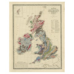
Geological Map of the British Isles by A.K. Johnston – Highlands & Valleys 1852
$312.87per item
£231.63per item
€260per item
CA$433.19per item
A$472.94per item
CHF 247.94per item
MX$5,744.04per item
NOK 3,096.41per item
SEK 2,923.84per item
DKK 1,979.44per item
Quantity
About the Item
Geological Map of the British Isles by A.K. Johnston – Highlands & Valleys 1852
This antique topographic map titled "The Mountains, Table Lands, Plains & Valleys of the British Isles" was created by Alexander Keith Johnston and published in 1852 by William Blackwood & Sons in Edinburgh and London. It forms Plate 10 in Johnston’s landmark *Physical Atlas of Natural Phenomena*, one of the most influential works of thematic cartography of the 19th century.
The map offers a clear and scientific representation of the physical geography of Great Britain and Ireland, highlighting major mountain ranges, highlands, plains, river valleys, and tablelands using fine engraved detail and hand-applied color washes. Rather than depicting political boundaries, this plate focuses entirely on natural landforms and their elevations, providing insight into the geological character of the region.
Key physical features include the Highlands and Grampians of Scotland, the Pennines in northern England, the Cambrian Mountains of Wales, and the Cumbrian Fells. Ireland is shown with its central lowlands ringed by uplands, and an inset in the upper right corner details the Shetland Islands. Rivers such as the Thames, Shannon, Severn, and Clyde are precisely mapped, and lowland basins like those surrounding the Wash and the Fens are delicately shaded in green.
This map reflects the mid-19th century shift from political and colonial maps to scientific and thematic cartography. Alexander Keith Johnston (1804–1871), Geographer in Ordinary to Queen Victoria in Scotland, was one of the leading cartographic figures of his time. His *Physical Atlas* was the first to systematically visualize natural phenomena on a global scale through beautifully engraved and colored maps. This map is part of that series and stands as a testament to the combination of precision, clarity, and aesthetic quality in Victorian scientific publishing.
Highly collectible and still relevant today, this plate is perfect for historians, educators, or anyone with an interest in British natural history and geography.
Condition and framing tips:
Very good antique condition with minor age toning and a clean printed surface. Original centerfold as issued.
Ideal for framing in walnut, oak, or black wood with a warm ivory or cool grey mat to complement the greens and earth tones. A beautiful addition to a study, library, or historically inspired interior.
- Dimensions:Height: 13.59 in (34.5 cm)Width: 10.79 in (27.4 cm)Depth: 0.01 in (0.2 mm)
- Materials and Techniques:
- Place of Origin:
- Period:
- Date of Manufacture:1852
- Condition:Very good condition. Light overall toning near the margins. The paper remains strong and well-preserved. Folding line as issued.
- Seller Location:Langweer, NL
- Reference Number:Seller: BG-13207-101stDibs: LU3054345388152
About the Seller
5.0
Recognized Seller
These prestigious sellers are industry leaders and represent the highest echelon for item quality and design.
Platinum Seller
Premium sellers with a 4.7+ rating and 24-hour response times
Established in 2009
1stDibs seller since 2017
2,641 sales on 1stDibs
Typical response time: <1 hour
- ShippingRetrieving quote...Shipping from: Langweer, Netherlands
- Return Policy
Authenticity Guarantee
In the unlikely event there’s an issue with an item’s authenticity, contact us within 1 year for a full refund. DetailsMoney-Back Guarantee
If your item is not as described, is damaged in transit, or does not arrive, contact us within 7 days for a full refund. Details24-Hour Cancellation
You have a 24-hour grace period in which to reconsider your purchase, with no questions asked.Vetted Professional Sellers
Our world-class sellers must adhere to strict standards for service and quality, maintaining the integrity of our listings.Price-Match Guarantee
If you find that a seller listed the same item for a lower price elsewhere, we’ll match it.Trusted Global Delivery
Our best-in-class carrier network provides specialized shipping options worldwide, including custom delivery.More From This Seller
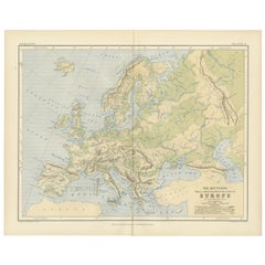
View AllGeological Map of Europe by A.K. Johnston – Mountains and Valleys 1852
Located in Langweer, NL
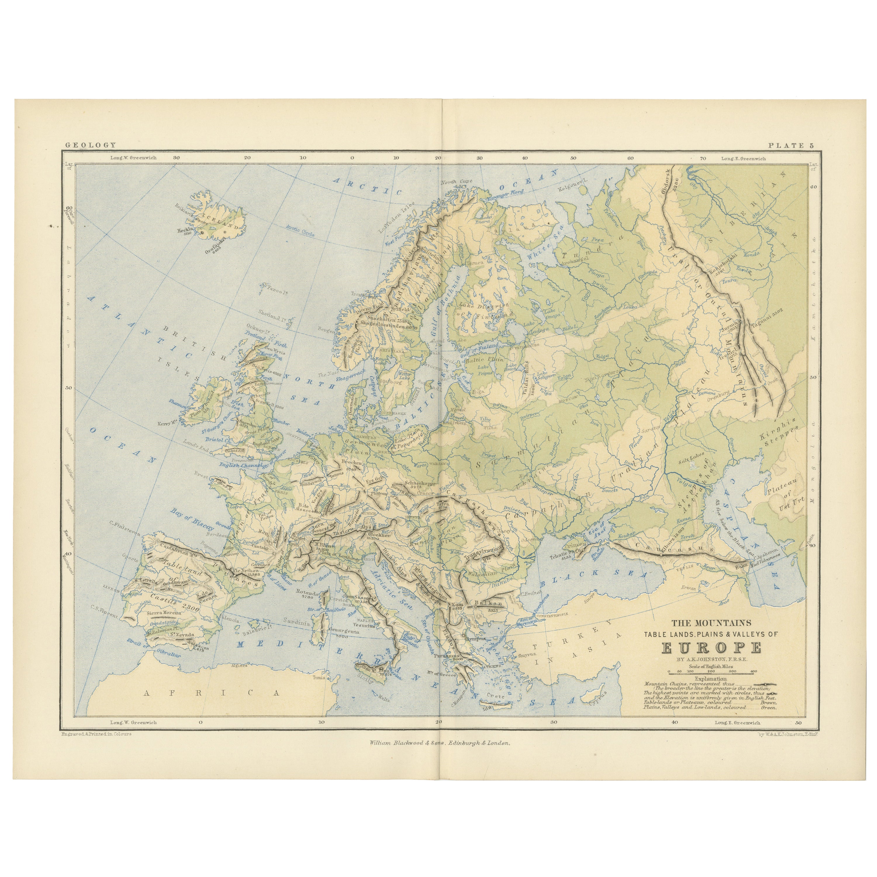
Geological Map of Europe by A.K. Johnston – Mountains and Valleys 1852
This elegant 1852 map titled "The Mountains, Table Lands, Plains & Valleys of Europe" was designed by the acclaimed Scottish geographer Alexander Keith Johnston and published by William Blackwood & Sons, Edinburgh and London. Issued as Plate 5 in Johnston’s pioneering work *The Physical Atlas of Natural Phenomena*, this map presents a physical topographic view of Europe with a focus on land elevation and terrain structure, rather than political borders.
Rendered in soft shades of beige, green, and blue, the map clearly delineates Europe’s major mountain ranges, including the Alps, Pyrenees, Carpathians, Apennines, and the Scandinavian Mountains. Valleys, upland plateaus, and lowlands are carefully shaded and labeled, giving a three-dimensional sense of the landscape. The careful use of hachuring and color gradients creates a tactile impression of Europe’s relief, from the Scottish Highlands to the Ural Mountains.
Rather than showing countries, the map categorizes the land by geological and geomorphological features. The title and key in the lower right explain the distinctions between highlands, tablelands, and low plains, emphasizing natural geography over human boundaries. This approach reflects the 19th-century scientific movement toward thematic cartography—maps made not to navigate or govern, but to understand physical phenomena.
Alexander Keith Johnston (1804–1871), Geographer in Ordinary to the Queen for Scotland, was one of the most respected mapmakers of the Victorian era. His *Physical Atlas* was a groundbreaking work in visual science, and among the first to systematically map climate, geology, hydrology, and landforms across the globe.
This plate is a beautifully executed example of early data visualization and remains highly relevant for collectors of antique scientific prints...
Category
Antique Mid-19th Century Scottish Prints
Materials
Paper
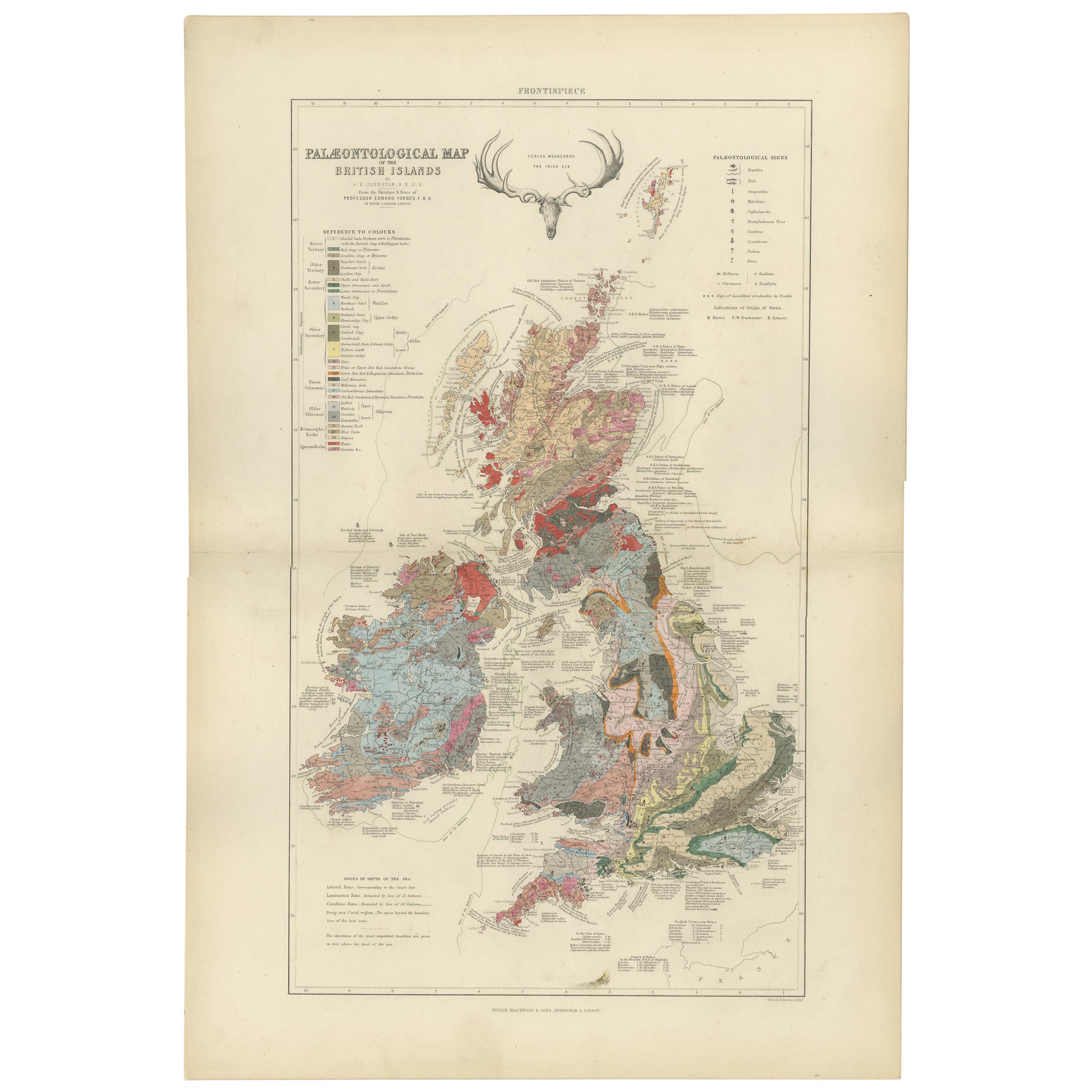
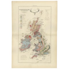
Antique Map of the Palaeontology of the British Isles by Johnston '1850'
Located in Langweer, NL
Antique map titled 'Palaeontological Map of the British Islands'. Original antique map showing the palaeontology of the British Isles. This map originates from 'The Physical Atlas of...
Category
Antique Mid-19th Century Maps
Materials
Paper
$433 Sale Price
20% Off
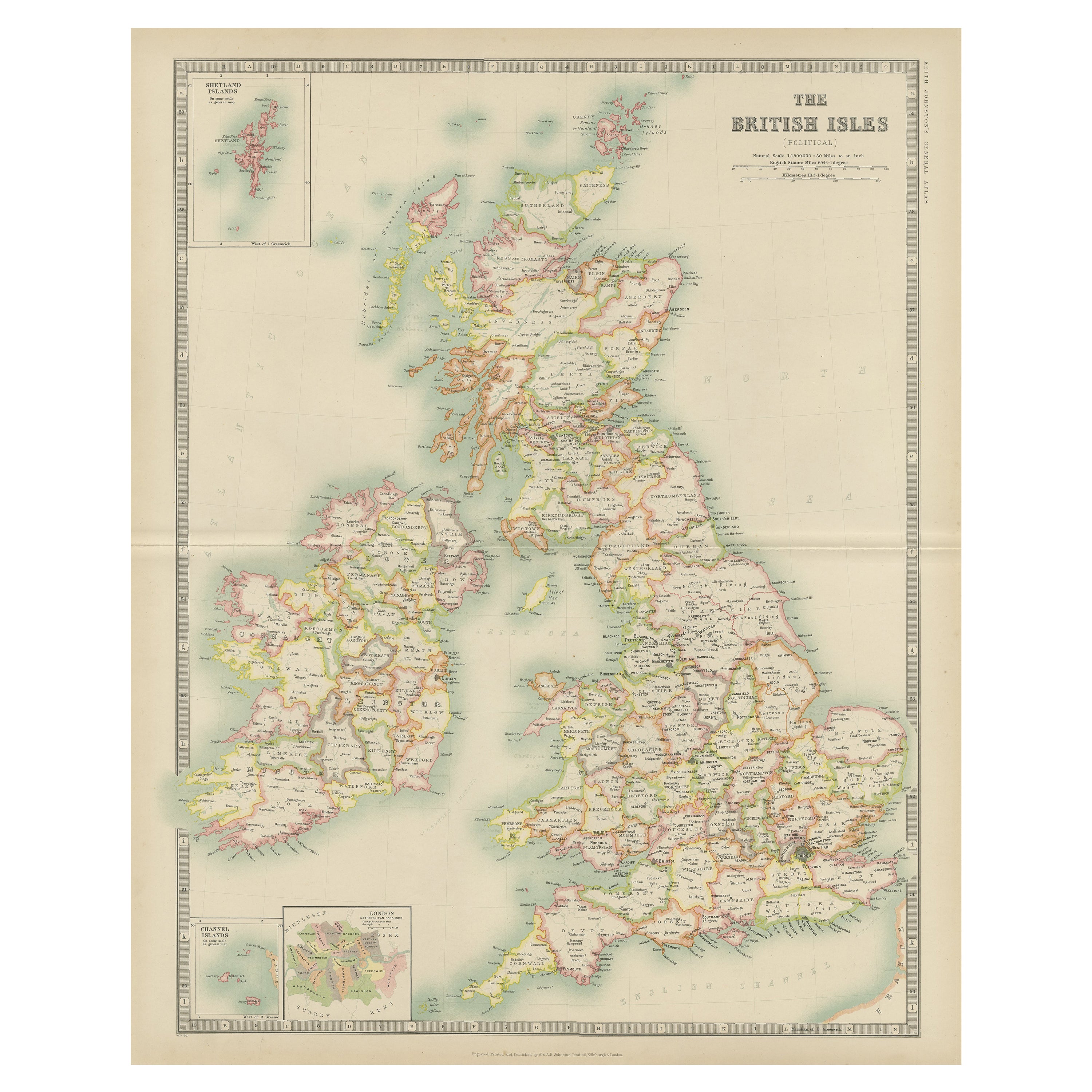
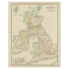
Antique Map of the British Isles by Johnston '1909'
Located in Langweer, NL
Antique map titled 'The British Isles'. Original antique map of the British Isles. With inset maps of the Shetland Islands, Chanel Islands, and London. T...
Category
Early 20th Century Maps
Materials
Paper
$240 Sale Price
20% Off
Beneath the Surface: James Wyld's 1844 Geological Map of the British Isles
Located in Langweer, NL
This superb original geological map of the United Kingdom of Great Britain and Ireland by James Wyld, produced in 1844, is a remarkable Victorian artifact.
Description:
Explore th...
Category
Antique 1840s Maps
Materials
Paper
$866 Sale Price
20% Off
Antique Map of the British Isles by Balbi '1847'
Located in Langweer, NL
Antique map titled 'Iles Britanniques'. Original antique map of the British Isles. This map originates from 'Abrégé de Géographie (..)' by Adrien Balbi. ...
Category
Antique Mid-19th Century Maps
Materials
Paper

$144 Sale Price
20% Off
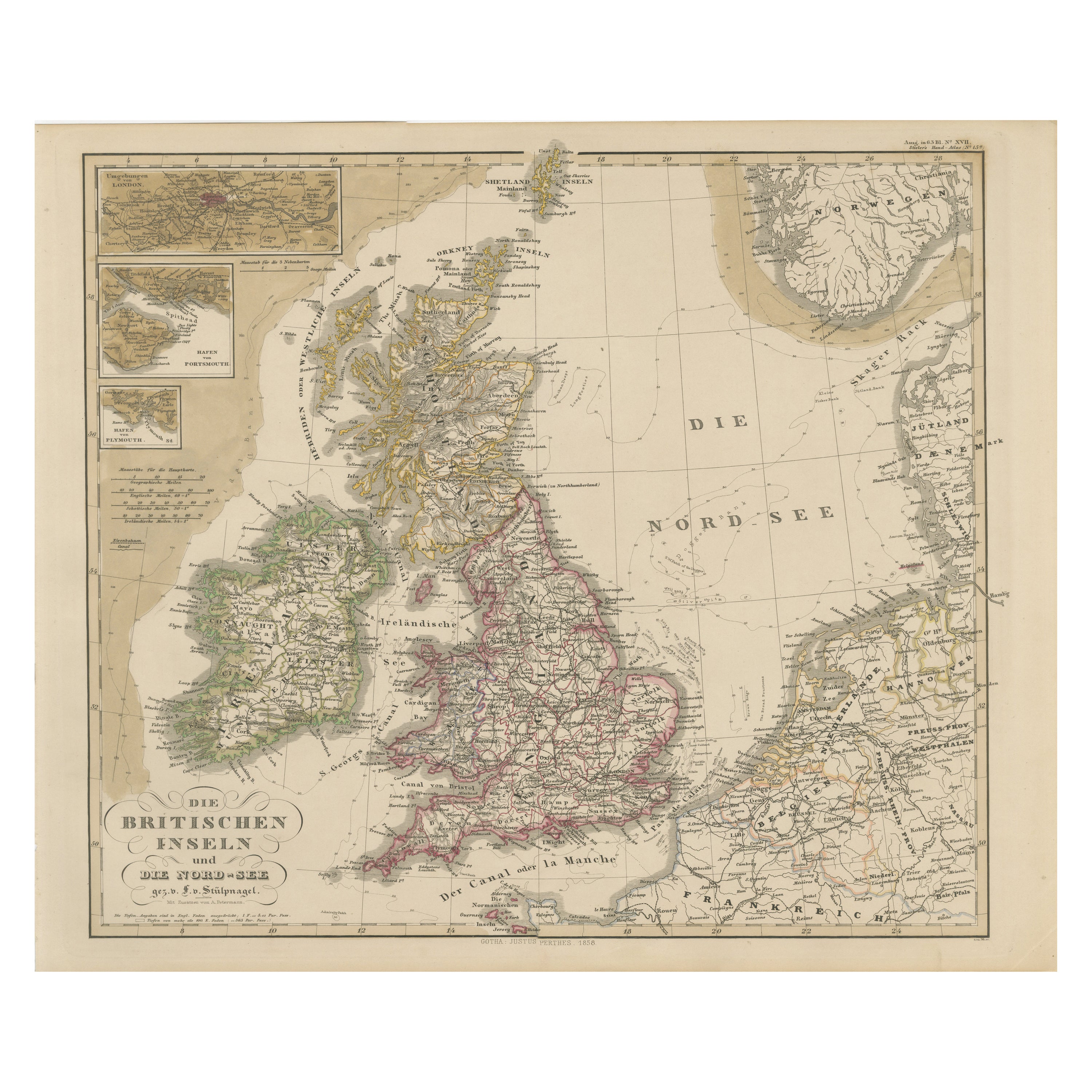
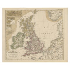
Antique Map of Britain & Ireland with North Sea Detail – 1856 Stülpnagel
Located in Langweer, NL
Antique Map of the British Isles & North Sea by Stülpnagel, 1856
This beautifully detailed 1856 map titled *"Die Britischen Inseln und die Nord-See"* was drawn by F. von Stülpnagel ...
Category
Antique Mid-19th Century German Maps
Materials
Paper
You May Also Like
Original Antique Map of Scotland by Dower, circa 1835
Located in St Annes, Lancashire
Nice map of Scotland
Drawn and engraved by J.Dower
Published by Orr & Smith. C.1835
Unframed.
Free shipping
Category
Antique 1830s English Maps
Materials
Paper

England and Wales, Northern Part. Century Atlas antique vintage map
Located in Melbourne, Victoria
'The Century Atlas. England and Wales, Northern Part'
Original antique map, 1903.
Central fold as issued. Map name and number printed on the reverse corners.
Sheet 29.5cm by 40cm.
Category
Early 20th Century Victorian More Prints
Materials
Lithograph

Large Original Vintage Map of the United Kingdom, circa 1920
Located in St Annes, Lancashire
Great map of The United Kingdom
Unframed
Original color
By John Bartholomew and Co. Edinburgh Geographical Institute
Published, circa 1920
Free shipping.
Category
Vintage 1920s British Maps
Materials
Paper

Old Horizontal Map of England
By Tasso
Located in Alessandria, Piemonte
ST/520 - Old rare Italian map of England, dated 1826-1827 - by Girolamo Tasso, editor in Venise, for the atlas of M.r Le-Sage.
Category
Antique Early 19th Century Italian Other Prints
Materials
Paper

England and the British Isles: A Large 17th Century Hand-colored Map by de Wit
By Frederick de Wit
Located in Alamo, CA
This is a large hand-colored 17th century map of England and the British Isles by Frederick de Wit entitled "Accuratissima Angliæ Regni et Walliæ Principatus", published in Amsterdam in 1680. It is a highly detailed map of England, Scotland, the Scottish Isles...
Category
Late 17th Century Other Art Style Landscape Prints
Materials
Engraving

Original Antique English County Map - Monmouthshire. J & C Walker. 1851
Located in St Annes, Lancashire
Great map of Monmouthshire
Original colour
By J & C Walker
Published by Longman, Rees, Orme, Brown & Co. 1851
Unframed.
Category
Antique 1850s English Other Maps
Materials
Paper

More Ways To Browse
Bronze Black Panthers
Bronze Chinoiserie Clock
Bronze Marly Horses
Bronze Singing Bowl
Bronze Sparrow
Brutalist Horse
Brutalist Zodiac
Buddha Head On Black Stand
Buffalo Horn Furniture
Bugatti Sculpture
Buncheong Ceramics
Cabinets Anglo Indian Rosewood
Carrera Dining Table
Carved Bone Elephants
Carved Censer
Carved Indian Chest
Carved Jade Figure
Carved Shell Cabinet