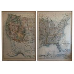
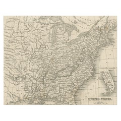
Map of United States Territories and Insular Possesssions, circa 1953
View Similar Items


1 of 2
Map of United States Territories and Insular Possesssions, circa 1953
About the Item
- Dimensions:Height: 64.5 in (163.83 cm)Width: 44.5 in (113.03 cm)Depth: 2 in (5.08 cm)
- Sold As:Set of 2
- Style:Other (Of the Period)
- Materials and Techniques:
- Place of Origin:
- Period:
- Date of Manufacture:Unknown
- Condition:
- Seller Location:West Hollywood, CA
- Reference Number:Seller: MAP002E1stDibs: LU85693788982
You May Also Like
- Old Decorative Pictorial Map of the United States, circa 1953Located in Langweer, NLAntique map titled 'A Pictorial Map of the United States of America Showing Principal Regional Resources, Products, and Natural Features'. This information-packed map was create by the General Drafting Company for the New Jersey Bell Telephone Company. The main map features over 700 drawings in full color including points of interest, natural resources, and agricultural products. At bottom are inset maps showing railroad lines, air routes, telephone lines, as well as a pictorial map of New Jersey...Category
20th Century Maps
MaterialsPaper
 $659 Sale Price20% Off
 - Small Map of the United StatesLocated in Langweer, NLAntique map titled 'Amérique septe. Physique'. Small map of the United States. lithographed by C. Callewaert brothers in Brussels circa 1870.Category
Antique Mid-19th Century Maps
MaterialsPaper
- Original Antique Hand-colored Map of the United States, circa 1845Located in Langweer, NLAntique map titled 'United States'. Old map of the United States, includes the last part of the North West Territory (present day Wisconsin and part of Minnesota). It also marks Ft. Crawford at the confluence of the Mississippi River and the Ouisconsin River (present day Wisconsin River). Published by Orr & Company; Amen Corner...Category
Antique Mid-19th Century Maps
MaterialsPaper
 $131 Sale Price20% Off
 - Original Antique Map of United States, Grattan and Gilbert, 1843Located in St Annes, LancashireGreat map of United States Drawn and engraved by Archer Published by Grattan and Gilbert. 1843 Original colour Unframed.Category
Antique 1840s English Maps
MaterialsPaper
- Antique Map of the Eastern United States with Inset Map of TexasLocated in Langweer, NLAntique map titled 'Verein-Staaten von Nord-America mit Ausnahme Florida's und der Westlichen Territorien'. This map extends as far west as Louisiana and only includes the northern p...Category
Antique Mid-19th Century Maps
MaterialsPaper
 $474 Sale Price20% Off
 - Steel Engraved Map of the United States with Inset Map of FloridaLocated in Langweer, NLAntique map titled 'United States'. Steel engraved map of the United States. With small inset map of the continuation of Florida. Source unknown, to be determined. Published circa 1843.Category
Antique Mid-19th Century Maps
MaterialsPaper


Recently Viewed
View AllMore Ways To Browse
Retro United States Map
Bureau Vintage 1950
Secretary Bureau
Pair Secretary
Pair Of Secretary
Secretary Pair
Pair Secretaries
Pair Of Secretaries
Reproduction Vintage Maps
Italian Wedding Designers
90 Clothes
Swing Door
Aged Black Wood Cabinet
French Chest 19th Painted
Swing Doors
1920s San Antonio
Milestone French
Vanity Mirror In Wood