Items Similar to Map of Ancient Rome - Original Etching by Alessandro Moschetti - 1848

Want more images or videos?
Request additional images or videos from the seller
1 of 5
Alessandro MoschettiMap of Ancient Rome - Original Etching by Alessandro Moschetti - 18481848
1848
$354.02
£269.04
€300
CA$497.42
A$545.41
CHF 285.12
MX$6,532.33
NOK 3,596.79
SEK 3,373.79
DKK 2,286.01
About the Item
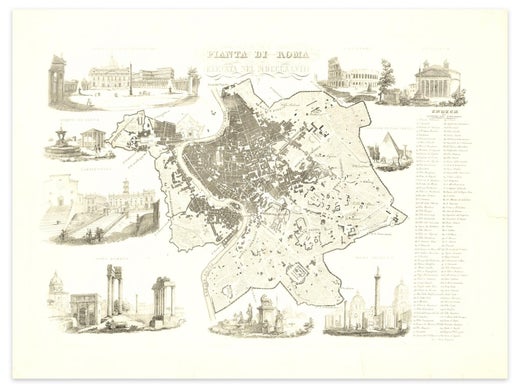
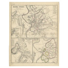
Plan of Rome is a beautiful original black and white etching, a rare and antique illustrated map of the eternal city of Rome, published in 1848.
Image Dimensions: 29.5 x 43 cm
Original title: Pianta di Roma elevata nel MDCCCXLVIII, engraved at the center of the higher margin.
This original print was the frontispiece of the book "Principali vedute di Roma" illustrated with 32 or 34 etchings (it depends on the edition) of Roman views by Alessandro Moschetti, published in Rome.
In the middle of the sheet, there is a high or "elevated" view of Rome, as the title suggests, and its main historical monuments numbered. On the right, there is a corresponding index of the most notable places (engraved all around the central plan of Rome) such as "Trajan's Forum, Roman Forum, Campidoglio, Temple of Vesta, Piazza Di S. Pietro in the Vatican, Colosseum, Pantheon and Pyramid of Cajo Cestio" .
In very good conditions, except for three rips of the paper restored and some thinnings of the paper, this is an interesting and precious piece to collect!
- Creator:Alessandro Moschetti (Italian)
- Creation Year:1848
- Dimensions:Height: 14.18 in (36 cm)Width: 18.9 in (48 cm)Depth: 0.04 in (1 mm)
- Medium:
- Period:
- Framing:Framing Options Available
- Condition:Insurance may be requested by customers as additional service, contact us for more information.
- Gallery Location:Roma, IT
- Reference Number:Seller: J-771211stDibs: LU65038029672
Alessandro Moschetti
Alessandro Moschetti was an Italian printmaker, who specialized in vedute. He published groups of Roman views in the 1840s and 1850s, notably the Nuova raccolta delle vedute di Roma antica e moderna disegnate sul vero da varij artist, published in Rome in 1843 and the Album delle piu interessanti vedute di Roma, to which he contributed along with Domenico Amici and Gaetano Cottafavi, published in Rome in 1855.
About the Seller
4.9
Platinum Seller
Premium sellers with a 4.7+ rating and 24-hour response times
1stDibs seller since 2017
7,784 sales on 1stDibs
Typical response time: 1 hour
- ShippingRetrieving quote...Shipping from: Monaco, Monaco
- Return Policy
Authenticity Guarantee
In the unlikely event there’s an issue with an item’s authenticity, contact us within 1 year for a full refund. DetailsMoney-Back Guarantee
If your item is not as described, is damaged in transit, or does not arrive, contact us within 7 days for a full refund. Details24-Hour Cancellation
You have a 24-hour grace period in which to reconsider your purchase, with no questions asked.Vetted Professional Sellers
Our world-class sellers must adhere to strict standards for service and quality, maintaining the integrity of our listings.Price-Match Guarantee
If you find that a seller listed the same item for a lower price elsewhere, we’ll match it.Trusted Global Delivery
Our best-in-class carrier network provides specialized shipping options worldwide, including custom delivery.More From This Seller
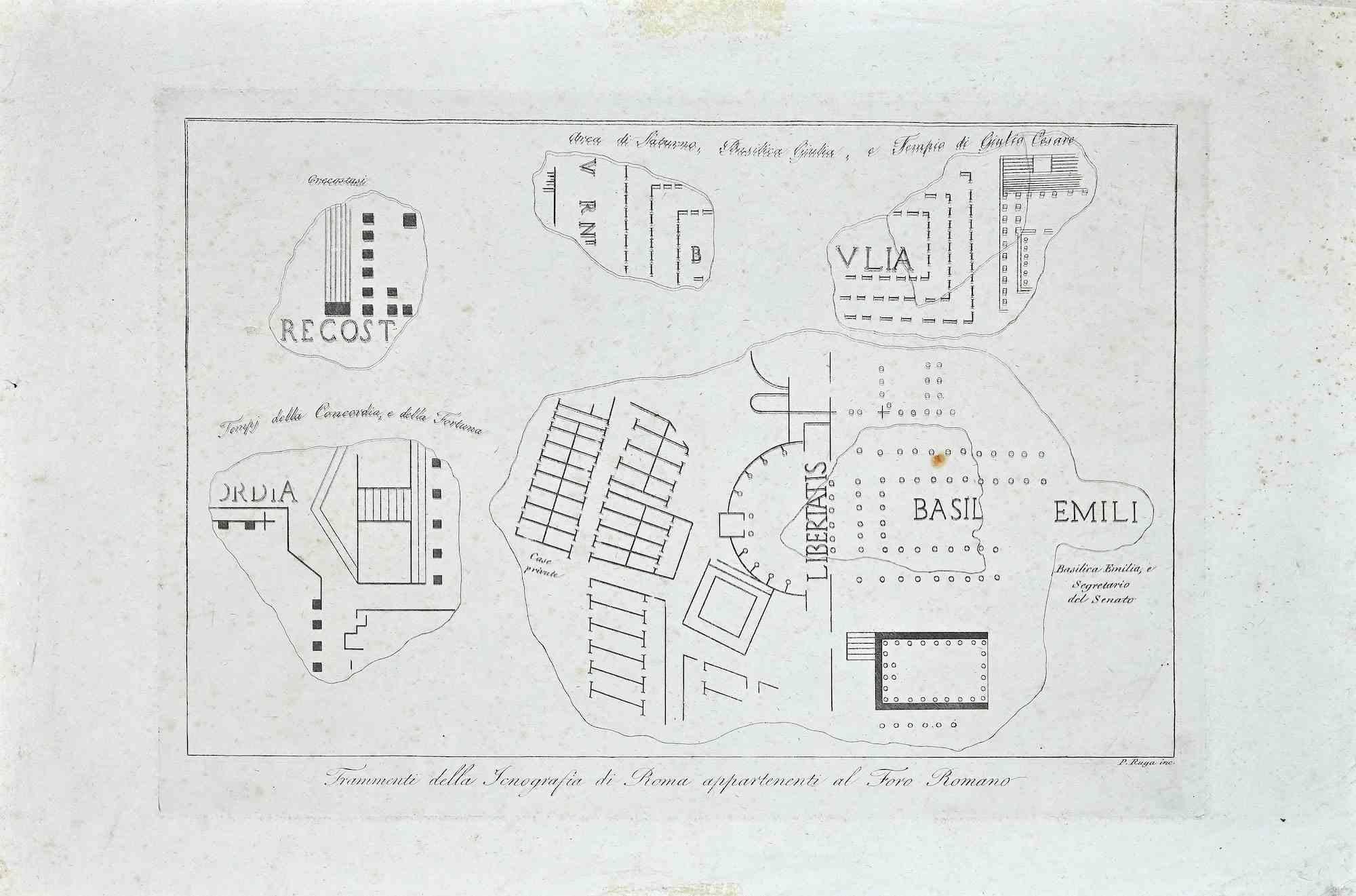
View AllMap of Forum Romanum - Original Etching by Pietro Ruga - 19th Century
Located in Roma, IT
Map of Forum Romanum is an original etching realized by Pietro Ruga 1849 ca.
Good Conditions except fr being aged with some small cutaways.
The artwork r...
Category
19th Century Modern More Prints
Materials
Etching

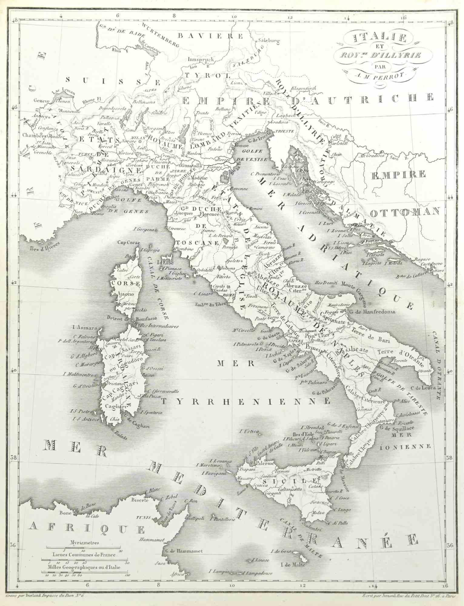
Map of Italy - Etching by Pierre François Tardieu - 1837
Located in Roma, IT
Map of Italy is an Etching realized in 1837.
Good conditions.
The artwork is realized in a well-balanced composition. the artwork and belongs to the suite suite "AtlasBatt" realize...
Category
1830s Modern Figurative Prints
Materials
Lithograph
Map of Lombardy - Original Etching - 19th Century
Located in Roma, IT
The Map of Lombardy is an original etching realized by an anonymous artist.
Fair conditions, the folding line of the middle is repaired.
The artwork represents the map of Lombardo....
Category
19th Century Modern Figurative Prints
Materials
Etching
Architectural Roman Map - Etching by Vincenzo Scarpati - 18th Century
Located in Roma, IT
Architectural Roman Map from "Antiquities of Herculaneum" is an etching on paper realized by Vincenzo Scarpati in the 18th Century.
Signed on the plate.
Go...
Category
18th Century Old Masters Figurative Prints
Materials
Etching

Map of Paris - Original Etching - 19th Century
Located in Roma, IT
This Map of Paris is an original print in etching technique.
The state of preservation of the artwork is very good.
This artwork represents a detailed map of the city of Paris..
Category
19th Century Figurative Prints
Materials
Etching

Map of the World - Original Etching - 1820
Located in Roma, IT
Map of the World is an Original Etching realized by an unknown artist of 19th century in 1820.
Very good condition on two sheets of white paper joine...
Category
1820s Modern Figurative Prints
Materials
Etching

You May Also Like
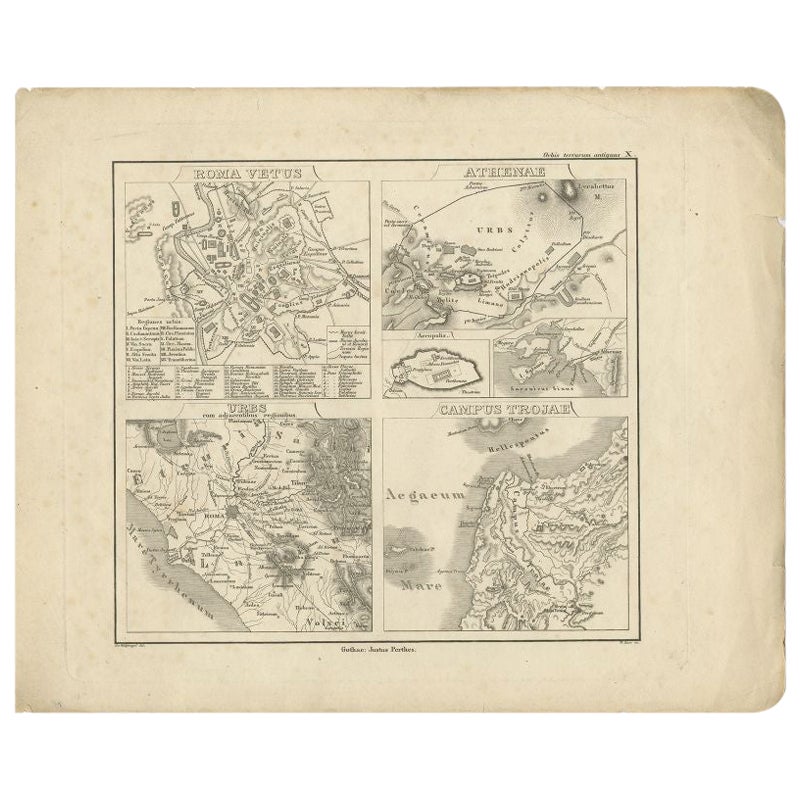
Antique Map of Rome and Athens by Perthes, 1848
Located in Langweer, NL
Antique map titled 'Roma Vetus, Athenae, Urbs, Campus Trojae'. Old map of Rome, Athens and surroundings originating from 'Orbis Terrarum Antiquus in usum S...
Category
Antique 19th Century Maps
Materials
Paper
$93 Sale Price
20% Off
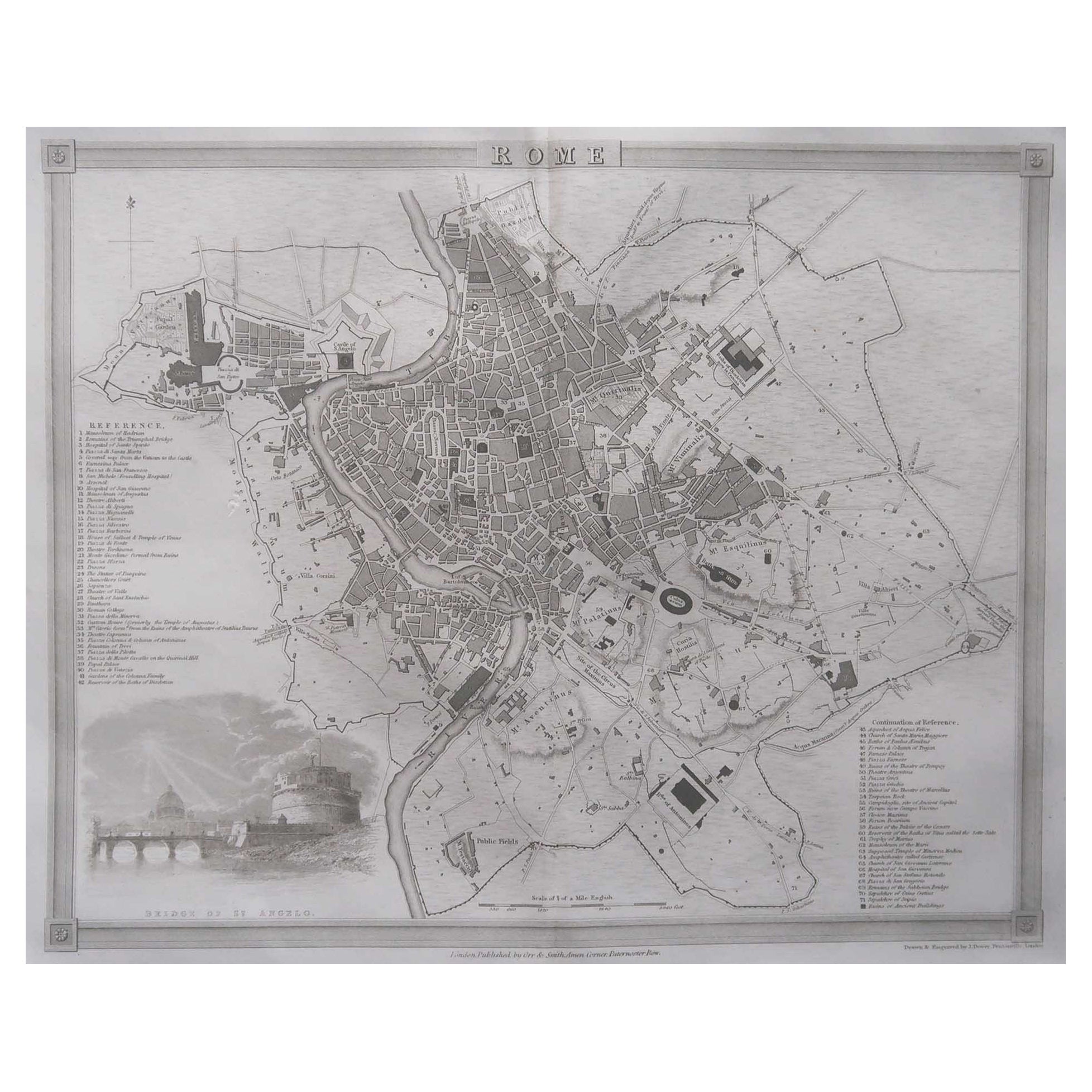
Original Antique Map or City Plan of Rome, Italy. Circa 1835
Located in St Annes, Lancashire
Nice map of Rome
Drawn and engraved by J.Dower
Published by Orr & Smith. C.1835
Unframed.
Free shipping
Category
Antique 1830s English Maps
Materials
Paper

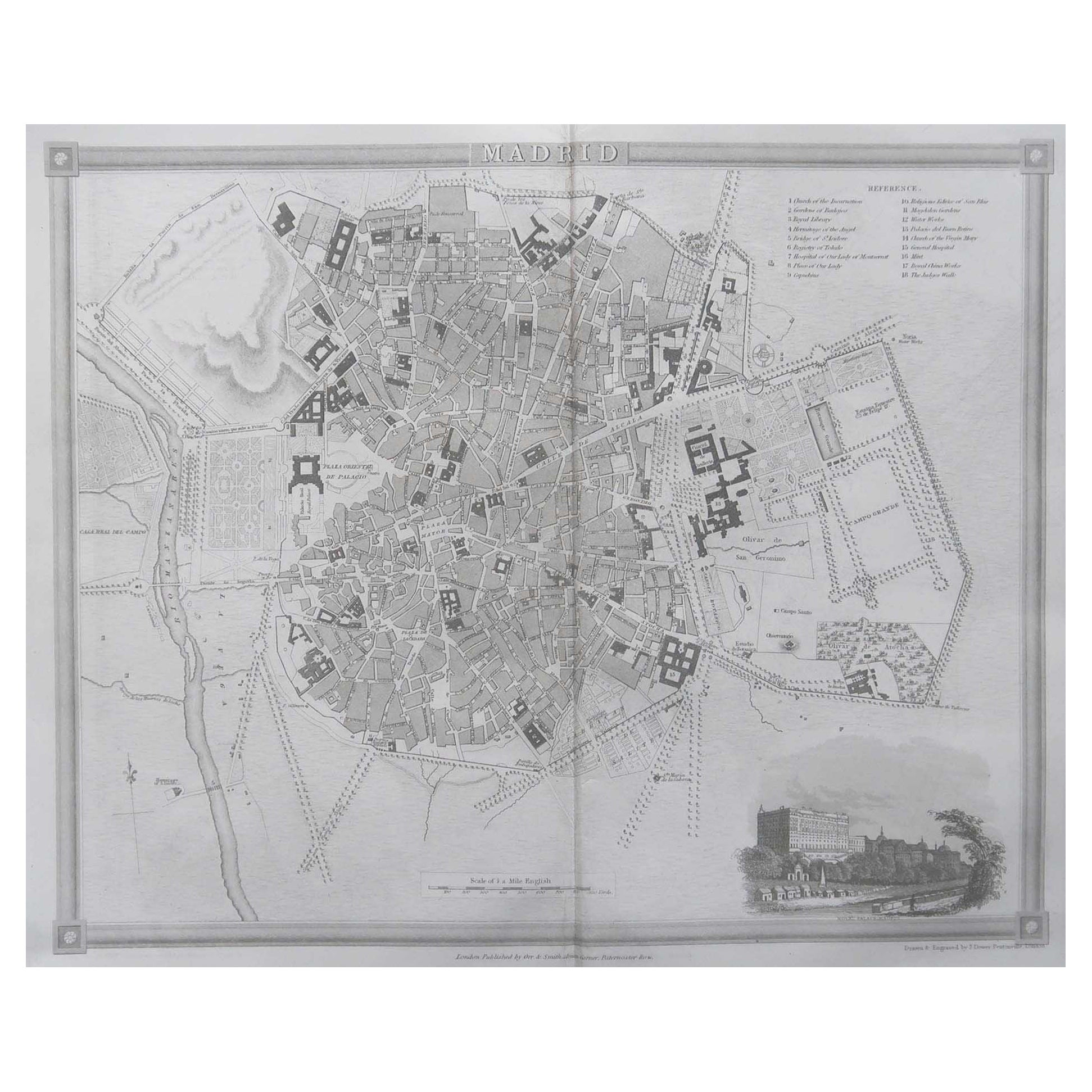
Original Antique Map or City Plan of Madrid, Spain. Circa 1835
Located in St Annes, Lancashire
Nice map of Madrid
Drawn and engraved by J.Dower
Published by Orr & Smith. C.1835
Unframed.
Free shipping
Category
Antique 1830s English Maps
Materials
Paper

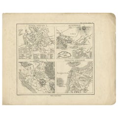
Detailed Original Antique Map of the Region of Rome in Italy, c.1870
By Heinrich Kiepert
Located in Langweer, NL
Antique map titled 'Roma Urbs'. Old map of Italy, it shows three inset maps of the region of Rome. This map originates from 'Atlas Antiquus, twaalf k...
Category
Antique 19th Century Maps
Materials
Paper
Paris and Surroundings – Antique Map by Gall and Inglis, Published 1843
Located in Langweer, NL
Antique Map of Paris and Environs by Gall and Inglis, 1843
This finely detailed map titled "Gall & Inglis’ Plan of Paris and Environs" was published in 1843 and provides a fascinati...
Category
Antique Mid-19th Century English Maps
Materials
Paper

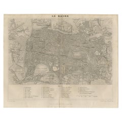
Antique Map of Cairo and Surroundings by Balbi '1847'
Located in Langweer, NL
Antique map titled 'Le Kaire'. Original antique map of Cairo and surroundings, Egypt. This map originates from 'Abrégé de Géographie (..)' by Adrien Balbi. Published 1847.
Category
Antique Mid-19th Century Maps
Materials
Paper
$141 Sale Price
20% Off
More Ways To Browse
Antique Forum
Antique Print Of Rome
Temple Vesta
Penal Cross
Peter Doig Zermatt
Peter Forster
Peter Max 9 11
Peter Max Earth Day
Peter Max Friends
Peter Max Ladies
Peter Max World Cup
Peter Wever On Sale
Phyllis Lucas Gallery Old Print Center
Picasso 156 Series Etchings
Picasso 1970 100
Picasso Bacchus
Picasso Eau Forte
Picasso Erotic Art