Items Similar to View of Blanmont - Etching by G. Braun and F. Hogenberg - Late 16th Century

Want more images or videos?
Request additional images or videos from the seller
1 of 5
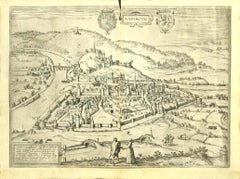
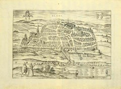
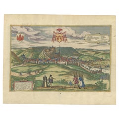
Franz HogenbergView of Blanmont - Etching by G. Braun and F. Hogenberg - Late 16th CenturyLate 16th Century
Late 16th Century
$591.56
£449.42
€500
CA$831.24
A$912.86
CHF 469.91
MX$10,922.67
NOK 5,982.95
SEK 5,606.91
DKK 3,808.89
About the Item
This map of Blanmont is an original etching realized by George Braun and Franz Hogenberg as part of the famous Series "Civitates Orbis Terrarum".
The “Civitates Orbis Terrarum” (Atlas of Cities of the World) was the second oldest printed atlas in the history of world cartography and the first atlas totally dedicated to topographical views. The first volume of this collection was published in Cologne in 1572; the following others in 1575, 1581, 1588, and 1598. The sixth and final volume appeared in 1617.
The state of preservation of the artwork is aged with diffused foxings and the middle lne on the folding had been cut and is partially repaired and a cut a way on the up-right anglr.
Sheet dimension :40.5 x 53.5
Interesting B/W etching on coeval paper, this artwork represents skilfully a detailed view of the city of Blanmont through confident strokes. "Blanmont" is printed at the top.
- Creator:Franz Hogenberg (1540 - 1590, Flemish)
- Creation Year:Late 16th Century
- Dimensions:Height: 15.95 in (40.5 cm)Width: 21.07 in (53.5 cm)Depth: 0.04 in (1 mm)
- Medium:
- Period:
- Framing:Framing Options Available
- Condition:Insurance may be requested by customers as additional service, contact us for more information.
- Gallery Location:Roma, IT
- Reference Number:Seller: M-1132791stDibs: LU65037308192

Franz Hogenberg
Braun and Hogenberg's 'The Civitates Orbis Terrarum' was the second atlas of maps ever published and the first atlas of cities and towns of the world. It is one of the most important books published in the 16th century. Most of the maps in the atlas were engraved by Franz Hogenberg and the text, with its descriptions of the history and additional factual information of the cities, was written by a team of writers and edited by Georg Braun. The work contained 546 bird-eye views and map views of cities and towns from all over the world. It gave graphic representation of the main features of the illustrated cities and towns, including the buildings and streets. Although the ordinary buildings are stylized, the principal buildings are reproduced from actual drawings created on location. The principal landmarks and streets can still be recognized today. In addition, the maps often include the heraldic arms of the city, the nature of the surrounding countryside, the important rivers, streams and harbors, even depicting stone bridges, wooden pontoons, flat-bottomed ferries, ships and working boats, wharves and jetties, as well as land-based activities, including horsemen, pedestrians, wagons, coaches, and palanquins. Small vignettes are often included which illustrate the trade, occupations and habits of the local inhabitants, such as agriculture, paper-making and textiles, as well as local forms of punishment, such as gibbets, wheels, floggings etc. Large figures dressed in their local costume are often presented out of proportion in the foreground. The aim of the authors was to give as much information as possible in a pleasing visual form. They succeeded in creating maps that were both informative and decorative works of art. The atlas is a wonderful glimpse of life in medieval Europe. Georg Braun (1541-1622) was German Catholic cleric who was born and who died in Cologne, Germany. He was the principal editor of 'The Civitates Orbis Terrarum', acquiring the tables, hiring the artists, and composing the texts. Abraham Ortelius, whose Theatrum Orbis Terrarum of 1570 was the first atlas of maps ever published, assisted Braun in his compilation of the details and maps for the atlas. The Civitates was intended as a companion for the Ortellius' Theatrum, as suggested by the similarity in the titles. Braun was the only survivor of the original team to live to see the publication of last volume (VI) in 1617. Franz Hogenberg (1535-1590) was a Flemish and German painter, engraver, and mapmaker. He was born in Mechelen (also known as Malines) in Flanders, the son of an engraver. After being expelled from Antwerp by the Duke of Alva, he moved to London and then eventually to Cologne, Germany, where he met Georg Braun and Abraham Ortellius. He engraved most of the plates for Ortelius's Theatrum and the majority of those in the Civitates. Many believe that he was responsible for originating the Civitates project.
About the Seller
4.9
Platinum Seller
Premium sellers with a 4.7+ rating and 24-hour response times
1stDibs seller since 2017
7,813 sales on 1stDibs
Typical response time: 1 hour
- ShippingRetrieving quote...Shipping from: Grasse, France
- Return Policy
More From This Seller
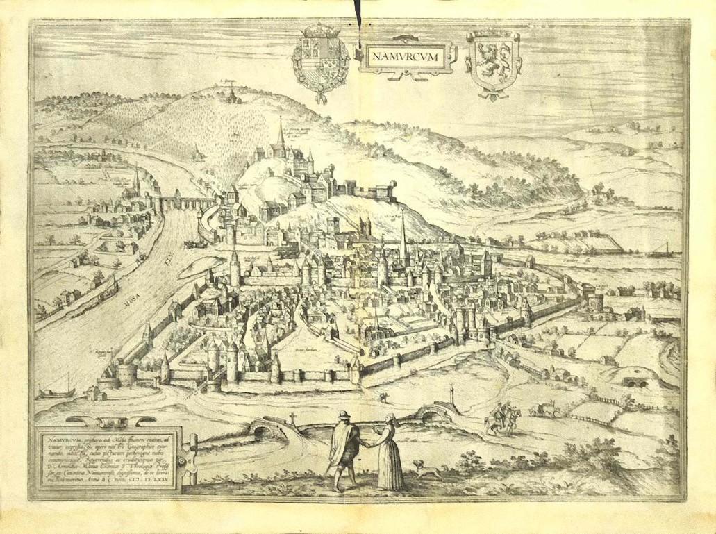
View AllView of Namur (Belgium) - Etching by G. Braun and F. Hogenberg - Late 1500
By Franz Hogenberg
Located in Roma, IT
This View of Namvrcvm (the ancient city of Namur, Belgium) is an original etching realized by George Braun and Franz Hogenberg, as part of the famous Series "Civitates Orbis Terrarum...
Category
16th Century Figurative Prints
Materials
Etching
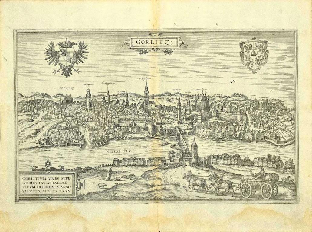
View of Gorlitz - Etching by G. Braun and F. Hogenberg - Late 16th Century
By Franz Hogenberg
Located in Roma, IT
This View of Gorlitz is an original etching realized by George Braun and Franz Hogenberg as part of the Series "Civitates Orbis Terrarum".
The “Civitates Orbis Terrarum” (Atlas of C...
Category
16th Century Figurative Prints
Materials
Etching
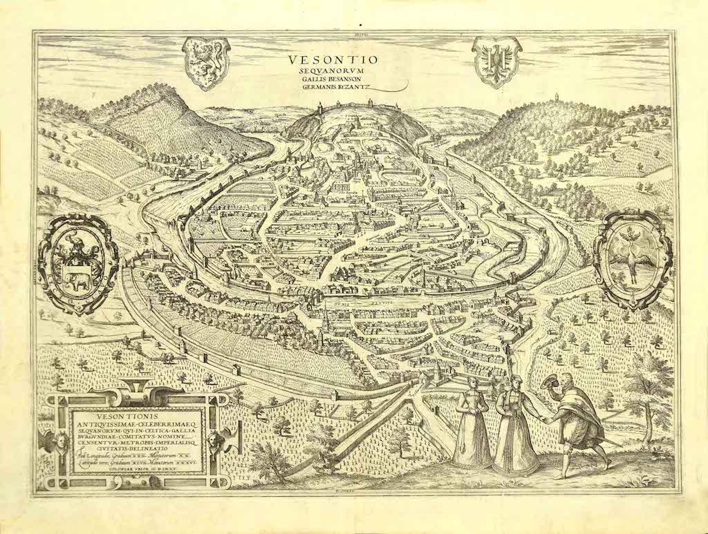
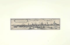
View of Vesontio - Etching by G. Braun and F. Hogenberg - Late 16th Century
By Franz Hogenberg
Located in Roma, IT
This View of Vesontio is an original etching realized by George Braun and Franz Hogenberg, as part of the famous Series "Civitates Orbis Terrarum".
The “Civitates Orbis Terrarum” (A...
Category
16th Century Figurative Prints
Materials
Etching
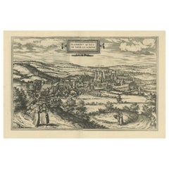
View of Blois - Etching by G. Braun and F. Hogenberg -Late 16th Century
By Franz Hogenberg
Located in Roma, IT
This view of Blois (ancient name: Bloys) is an original etching realized by George Braun and Franz Hogenberg as part of the famous "Civitates Orbis Terrarum".
The “Civitates Orbis T...
Category
16th Century Figurative Prints
Materials
Etching
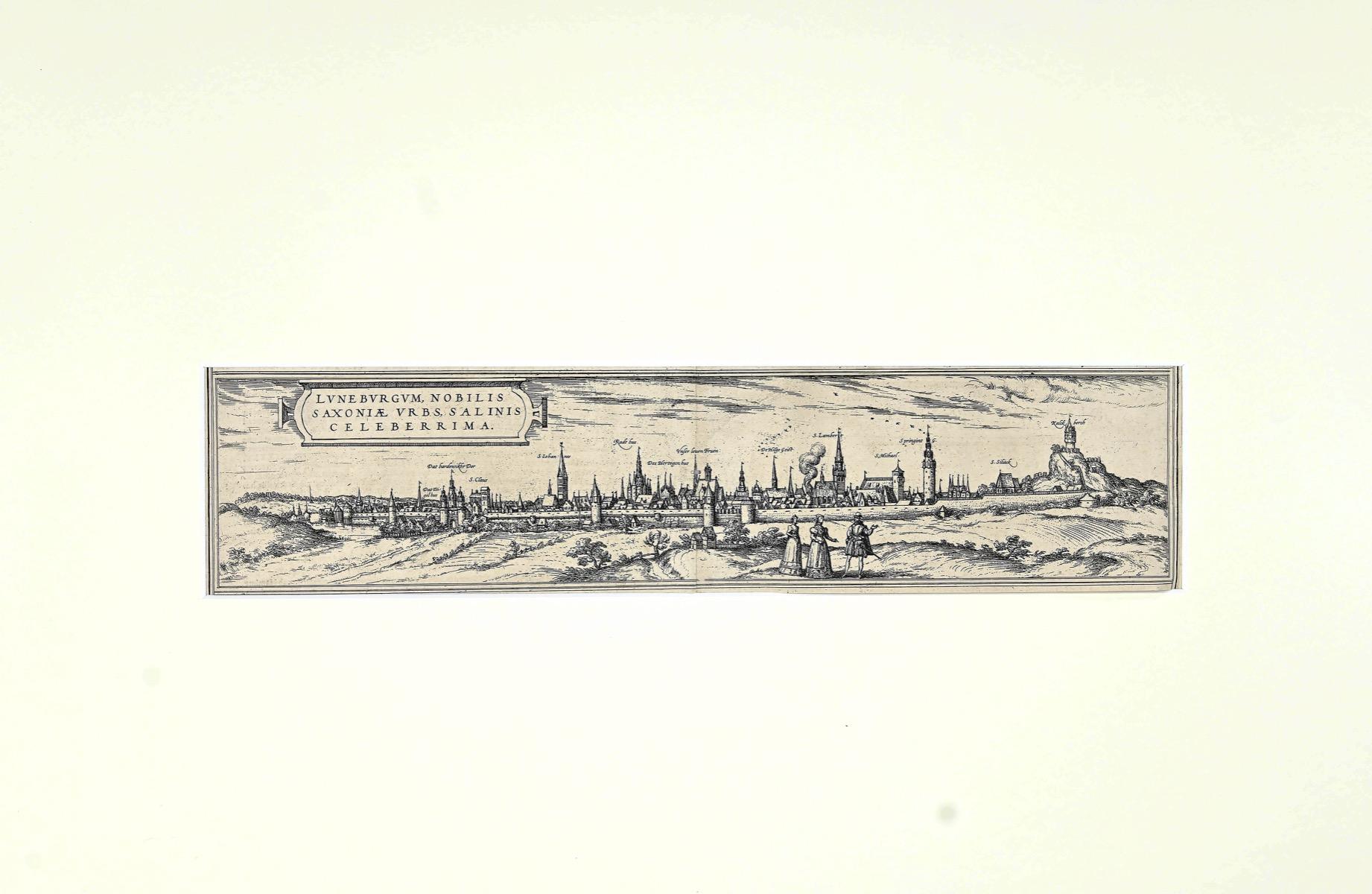
View of Lunenburg- Original Etching by Franz Hogenberg - Late 16th Century
By Franz Hogenberg
Located in Roma, IT
Luneburgo is an original etching realized by Georg Braun and Franz Hogenberg, as part of the famous "Civitates Orbis Terrarum".
Precious etching, show...
Category
16th Century Figurative Prints
Materials
Etching
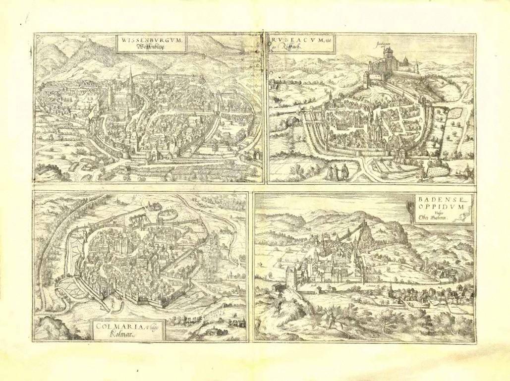
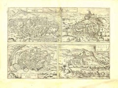
View of 4 Ancient German Cities - Etching by G. Braun and F. Hogenberg
By Franz Hogenberg
Located in Roma, IT
Maps is an original etching realized by G. Braun and F. Hogenberg as part of the so called "Civitates Orbis Terrarum".
The “Civitates Orbis Terrarum” (Atlas of Cities of the World) ...
Category
16th Century Figurative Prints
Materials
Etching
You May Also Like
Bird's-Eye View of Blâmont in Lorraine by Braun and Hogenberg, 1597
Located in Langweer, NL
Title: Bird's-Eye View of Blâmont in Lorraine by Braun and Hogenberg, 1597
This copperplate engraving, published in 1597 by Braun and Hogenberg, depicts a bird's-eye view of the t...
Category
Antique 16th Century Maps
Materials
Paper
$397 Sale Price
30% Off
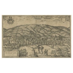
Limburg Cityscape 1580: Historical Copper Engraving by Braun and Hogenberg
Located in Langweer, NL
Title: Limburgum Oppidum Galliae Belgicae, vulgo Lympurch, gallicè, Lembor Dr.
Type: Print (Copper Engraving)
Circa 1580
Technique: Colored Copper Engraving
Medium: Handmade Paper
S...
Category
Antique 16th Century German Maps
Materials
Paper

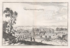
Castle and Town of Tanlay, French architecture, mid 17th century engraving
By Matthaeus Merian
Located in Melbourne, Victoria
'Prosp du Chasteau et Bourg de Tanlay'
Copper-line engraving by Matthaeus Merian.
From 'Topographia Galliae', a fine series of engravings of 17th-century French landscapes, garden...
Category
Mid-18th Century Rococo Landscape Prints
Materials
Engraving
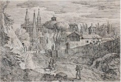
17th century etching black and white figurative landscape cityscape buildings
By Jan Frans van Bloemen (Orizzonte)
Located in Milwaukee, WI
"Figures Outside the Monastery" is an original etching by Jan Frans van Bloemen. It depicts people on the path to a church.
7" x 10 1/4" art
19 1/4" x 22 5/8" frame
Jan Frans van Bloemen (baptized 12 May 1662 - buried 13 June 1749) was a Flemish landscape painter mainly active in Rome. Here he was able to establish himself as the leading painter of views (vedute) of the Roman countryside depicted in the aesthetic of the classical landscape tradition.
Van Bloemen predominantly painted classical landscapes, taking his inspiration from the Roman Campagna. His landscapes, with their recession through a series of planes, soft, warm lightning and classical and religious subject matter, drew on the examples of artists such as Claude Lorrain and Gaspard Dughet. His paintings are exquisitely imbued with that "difficult-to-define pastoral ambience" which helped to make him such a great painter in the eyes of his contemporaries. The technique and subjects of the work of Jan Frans van Bloemen are also related to painters such as Jan Asselijn, Thomas Wyck...
Category
18th Century Old Masters Landscape Prints
Materials
Etching
Antique Print of Büdingenin Germany by Braun & Hogenberg, 1617
Located in Langweer, NL
Antique map titled 'Bingen'. Bird's eye-view of Büdingen, Germany. The view shows a city surrounded by vineyards and well fortified with walls and moats. On the right is the castle w...
Category
Antique 17th Century Prints
Materials
Paper
$274 Sale Price
20% Off
Huy (Huum) Cityscape 1574: Historical Copper Engraving by Braun & Hogenberg
Located in Langweer, NL
Title: Huum opp. condrusorum caput (...) Anno partae salutis 1574.
**Type:** Print (Colored Copper Engraving)
**Year:** Circa 1580
**Technique:** Colored Copper Engraving
**Medium:...
Category
Antique 16th Century Maps
Materials
Paper
$605 Sale Price
20% Off
More Ways To Browse
Dali Illustrates Casanova
Dali Man Of La Mancha
Dali Othello
Dali Pig And Pepper
Dali Purgatory Signed
Dali Saba
Dali Signed Ecstatic
Dali Skeleton
Dali Spinning Man
Dali The Annunciation
Dali Thus Was Earth Created
Dame Laura Knight On Sale
Danos Flower Shop
Daumier Actualites
David Ham
David Schluss Serigraph
David Shrigley You Are Special
Degas Poster