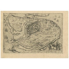
Items Similar to Map of San Georgi - Etching by G. Braun/F. Hogenberg - 1575
![[Civitates Orbis Terrarum]Map of Cefal - Etching by G. Braun/F. Hogenberg - 1575](https://a.1stdibscdn.com/georg-braun-and-franz-hogenberg-prints-works-on-paper-civitates-orbis-terrarummap-of-cefal-etching-by-g-braun-f-hogenberg-1575-for-sale/a_6503/a_137919521705507440775/J_71845_georg_braun_franz_hogenberg_civitates_orbis_terrarum_map_of_ce_1_master.jpg)
Want more images or videos?
Request additional images or videos from the seller
1 of 2
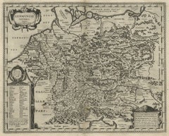
Georg Braun and Franz HogenbergMap of San Georgi - Etching by G. Braun/F. Hogenberg - 15751575
1575
$563.99
£430.50
€480
CA$795.54
A$873.87
CHF 456.69
MX$10,421.61
NOK 5,782.92
SEK 5,387.28
DKK 3,658.52
About the Item
Etching by Georg Braun and Frans Hogenberg, realized in 1575 and belonging to the Suite "Civitates Orbis Terrarum".
The first volume of the Civitates Orbis Terrarum was published in Cologne in 1572. The sixth and the final volume appeared in 1617.
This great city atlas, edited by Georg Braun and largely engraved by Franz Hogenberg, eventually contained 546 prospects, bird-eye views and map views of cities from all over the world. Braun (1541-1622), a cleric of Cologne, was the principal editor of the work, and was greatly assisted in his project by the close, and continued interest of Abraham Ortelius, whose Theatrum Orbis Terrarum of 1570 was, as a systematic and comprehensive collection of maps of uniform style, the first true atlas.
The Civitates, indeed, was intended as a companion for the Theatrum, as indicated by the similarity in the titles and by contemporary references regarding the complementary nature of two works. Nevertheless, the Civitates was designs to be more popular in approach, no doubt because the novelty of a collection of city plans and views represented a more hazardous commercial undertaking than a world atlas, for which there had been a number of successful precedents. Franz Hogenberg (1535-1590) was the son of a Munich engraves who settled in Malines. He engraved most of the plates for Ortelius's Theatrum and the majority of those in the Civitates, and may have been responsible for originating the project.
Over a hundred of different artists and cartographers, the most significant of whom was Antwerp artist Georg (Joris) Hoefnagel (1542-1600), engraved the cooper-plates of the Civitates from drawings. He not only contributed most of the original material for the Spanish and Italian towns but also reworked and modified those of other contributors. After Hoefnagel's death his son Jakob continued the work for the Civitates. A large number of Jacob van Deventer (1505-1575), also known as Jacob Roelofszof, unpublished works, plans of towns of the Netherlands were copied, as were Stumpf's woodcuts from the Schweizer Chronik of 1548, and Munster's German views from the 1550 and 1572 editions of his Cosmographia. Another important source for maps was the Danish cartographer Heinrich van Rantzau (1526-1599), beter known under his Latin name Rantzovius, who provided maps of Northern Europe, specially of Danish cities. The Civitates provided a uniquely comprehensive view of urban life at the turn of the sixteenth century. Other sources were the maps of Sebastian Munster from around 1550 and , and of.
Braun added to the maps figures in local dress. This feature was anticipated in Hans Lautensack's etched view of Nuremberg, 1552, those groups of citizens in the rural foreground add further authenticity to the highly accurate topographical details of what was effectively Germany's cultural capital at that time. Braun's motives for adding figures to the views, however, went further: as stated in his introduction to book 1, he believed, perhaps optimistically, that his plans would not in consequence be scrutinized for military secrets by the Turks, as their religion forbade them from looking on representations of the human form.
The plans, each accompanies by Braun's printed account of the town's history, situation and commerce, form an armchair traveler's compendium, which the scholar Robert Burton in The Anatomy of Melancholy of 1621 asserted would not only provide instructions but would uplift the spirit as well.
- Creator:Georg Braun and Franz Hogenberg
- Creation Year:1575
- Dimensions:Height: 5.52 in (14 cm)Width: 6.3 in (16 cm)Depth: 0.04 in (1 mm)
- Medium:
- Movement & Style:
- Period:
- Framing:Framing Options Available
- Condition:Insurance may be requested by customers as additional service, contact us for more information.
- Gallery Location:Roma, IT
- Reference Number:Seller: J-718611stDibs: LU650313791992
About the Seller
4.9
Platinum Seller
Premium sellers with a 4.7+ rating and 24-hour response times
1stDibs seller since 2017
7,817 sales on 1stDibs
Typical response time: 1 hour
- ShippingRetrieving quote...Shipping from: Grasse, France
- Return Policy
More From This Seller
View All[Civitates Orbis Terrarum]Map of Cefal - Etching by G. Braun/F. Hogenberg - 1575
Located in Roma, IT
Etching by Georg Braun and Franz Hogenberg, belonging to the "Civitates Orbis Terrarum".
Good condition.
The first volume of the Civitates Orbis Terrarum was published in Cologne in ...
Category
16th Century Contemporary Figurative Prints
Materials
Etching
![[Civitates Orbis Terrarum]Map of Cefal - Etching by G. Braun/F. Hogenberg - 1575](https://a.1stdibscdn.com/georg-braun-and-franz-hogenberg-prints-works-on-paper-civitates-orbis-terrarummap-of-cefal-etching-by-g-braun-f-hogenberg-1575-for-sale/a_6503/a_137919521705507440775/J_71845_georg_braun_franz_hogenberg_civitates_orbis_terrarum_map_of_ce_1_master.jpg?width=240)
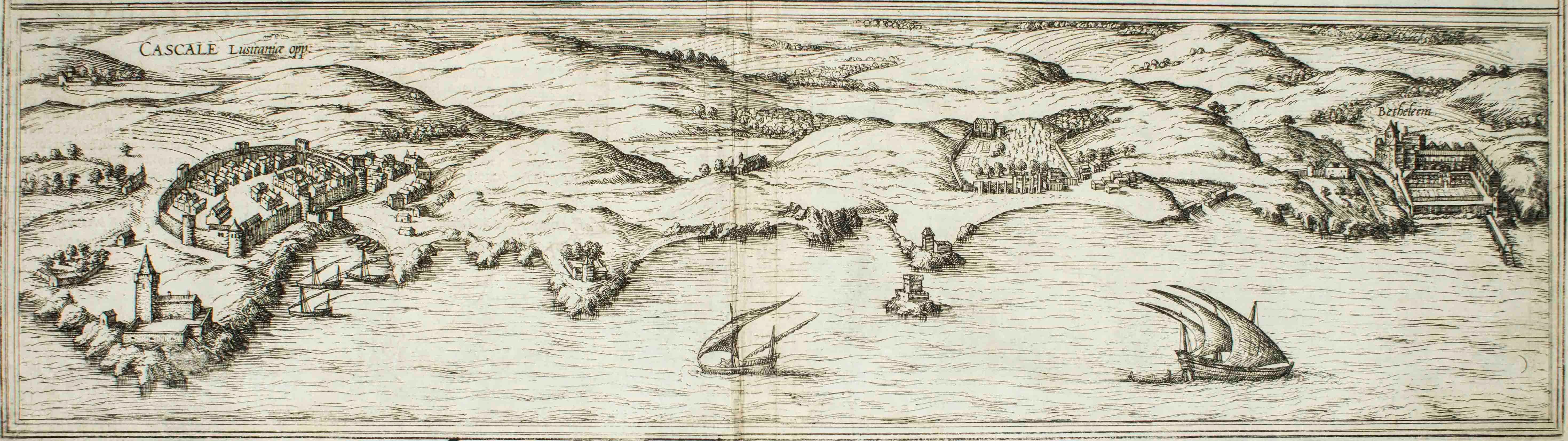
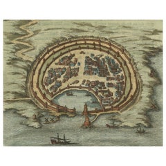
Cascale, Map from "Civitates Orbis Terrarum" - by F. Hogenberg - 1575
By Franz Hogenberg
Located in Roma, IT
Braun G., Hogenberg F., Cascale, from the collection Civitates Orbis Terrarum, Cologne, T. Graminaeus, 1572-1617.
Good conditions expect tue usual central fold.
The “Civitates Orbis...
Category
16th Century Figurative Prints
Materials
Etching, Aquatint
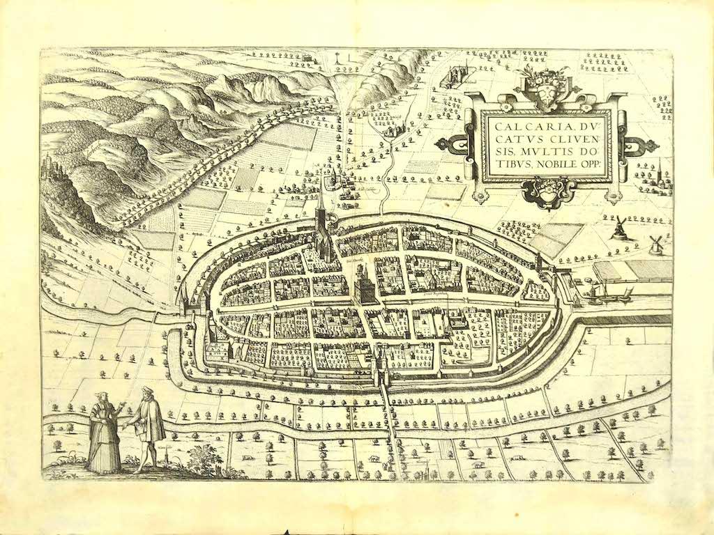
Map of Kalkar - Etching by G. Braun and F. Hogenberg - Late 16th Century
By Franz Hogenberg
Located in Roma, IT
This map of Calcaria is an original etching realized by George Braun and Franz Hogenberg, as part of the famous Series "Civitates Orbis Terrarum" (Atlas of the Cities of the World)....
Category
16th Century Figurative Prints
Materials
Etching
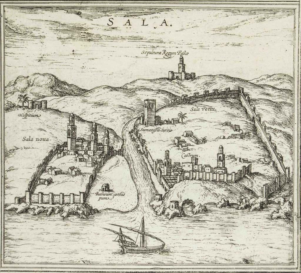
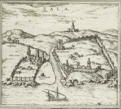
Sala, Map from "Civitates Orbis Terrarum" - by F.Hogenberg - 1575
By Franz Hogenberg
Located in Roma, IT
"Sala", from the collection "Civitates Orbis Terrarum", Cologne, T. Graminaeus, 1575.
The “Civitates Orbis Terrarum” (Atlas of Cities of the World) was the second oldest printed a...
Category
16th Century Figurative Prints
Materials
Etching, Aquatint
$411 Sale Price
30% Off
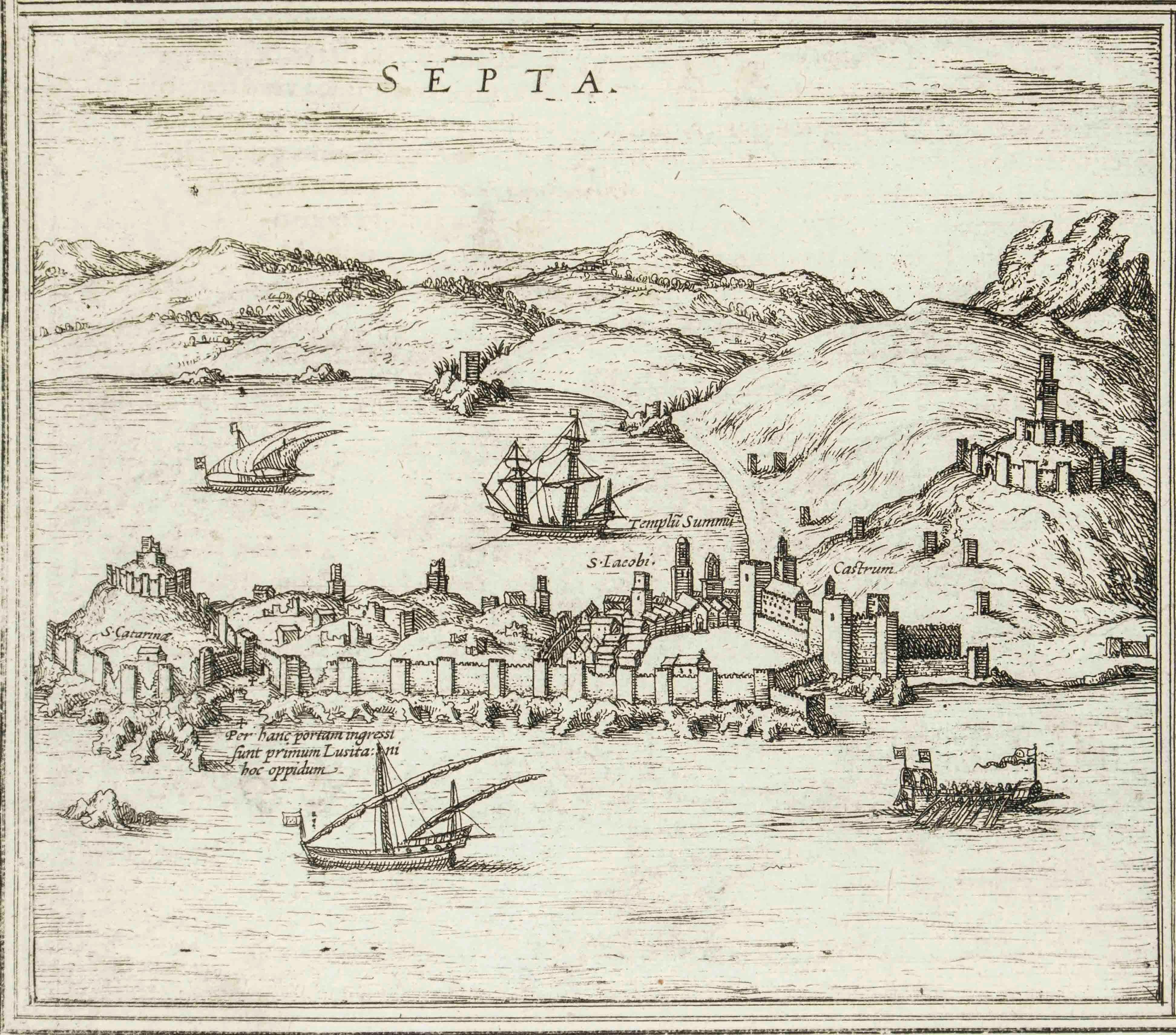
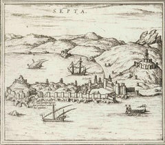
Septa, Map from "Civitates Orbis Terrarum" - by F.Hogenberg - 1575
By Franz Hogenberg
Located in Roma, IT
"Septa", from the collection "Civitates Orbis Terrarum", Cologne, T. Graminaeus, 1575.
The “Civitates Orbis Terrarum” (Atlas of Cities of the World) was the second oldest printed ...
Category
16th Century Figurative Prints
Materials
Etching, Aquatint
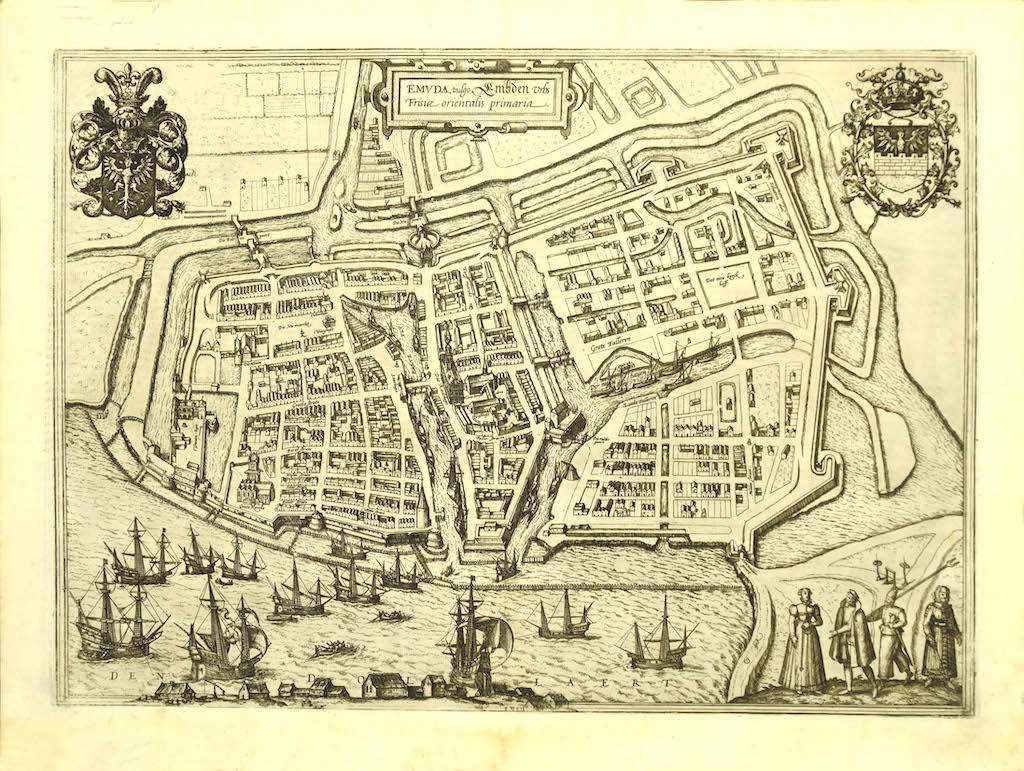
Map of Embden - Original Etching by G. Braun e F. Hogenberg - Late 16th Century
By Franz Hogenberg
Located in Roma, IT
This map of Embdena is an original etching realized by George Braun and Franz Hogenberg in the Late 16th Century, as part of the famous Series "Civitates Orbis Terrarum" (Atlas of t...
Category
16th Century Figurative Prints
Materials
Etching

You May Also Like
Rugen Island, Germany: An Early 17th Century Map by Mercator and Hondius
By Gerard Mercator
Located in Alamo, CA
This is an early 17th century map entitled "Nova Famigerabilis Insulae Ac Ducatus Rugiae Desciptio" (Map of Rugen Island, Germany) by Gerard Mercator and Henricus and Joducus Hondiu...
Category
Early 17th Century Old Masters Landscape Prints
Materials
Engraving

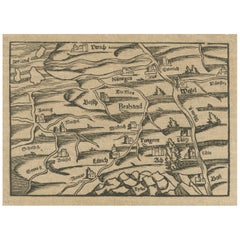
Rare 16th Century Woodcut Map of Brabant and the Rhine Valley, circa 1549
Located in Langweer, NL
Title: Rare 16th Century Woodcut Map of Brabant and the Rhine Valley, circa 1550
Description:
This rare and highly decorative early woodcut map depicts the region of Brabant and the...
Category
Antique 16th Century German Maps
Materials
Paper
Antique Engraving with a Plan of Rhodes, Greece, 1688
Located in Langweer, NL
Description: Antique map, titled: 'Rhodos.' - Plan of Rhodes, Greece. This map originates from 'Nauwkeurige Beschrijving der eilanden in de in de Archipel der Middellantsche Zee', by...
Category
Antique 1680s Maps
Materials
Paper
$423 Sale Price
20% Off
Antique Map of the City of Brielle 'The Netherlands' by L. Guicciardini, 1625
Located in Langweer, NL
Plan of Brielle, Briel, Den Briel in the Province of Zuid-Holland, The Netherlands, Holland. This map originates from the 1625 edition of 'Discrittione di tutti i Paesi Bassi', by L....
Category
Antique Early 17th Century Maps
Materials
Paper
Original Rare Antique Map of the Ancient German Empire in Northern Europe, c1650
Located in Langweer, NL
Antique map titled 'Germaniae Veteris typus.'
Map of the ancient German Empire in Northern Europe, based upon an earlier map by Ortelius. Extends fr...
Category
Antique 1650s Maps
Materials
Paper
$620 Sale Price
20% Off
Antique Map of the Bay of Bantam, c.1720
Located in Langweer, NL
Rare, untitled miniature map of the Bay of Bantam with various Islands including Pulo Dua and Pulo Batto. This map originates from a small travelogue and may originate from an editio...
Category
Antique 18th Century Maps
Materials
Paper

$56 Sale Price
20% Off
More Ways To Browse
Denmark Map
Antique Map Denmark
Sebastian Munster
Gilot Signed
Henri de Toulouse-Lautrec On Sale
Henri Matisse Danseuse
Henry De Groux
Hogarth Etching
Iwo Jima
Jacques Jacob
Jean De Paleologue
Jim Dine Dorian
John Buckland Wright
Journal Des Demoiselles
Kathe Kollwitz Etchings
Kees van Dongen On Sale
Keith Haring Eye
Keith Haring Radiant Baby