Items Similar to Map of Scotland - Etching by Johannes Blaeu - 1650s
Want more images or videos?
Request additional images or videos from the seller
1 of 6
Johannes BlaeuMap of Scotland - Etching by Johannes Blaeu - 1650s1650s
1650s
$444.64
$556.0920% Off
£337.92
£422.6320% Off
€375
€46920% Off
CA$623.89
CA$780.2820% Off
A$680.81
A$851.4620% Off
CHF 353.38
CHF 441.9620% Off
MX$8,145.26
MX$10,187.0120% Off
NOK 4,485.50
NOK 5,609.8620% Off
SEK 4,201.51
SEK 5,254.6920% Off
DKK 2,857.15
DKK 3,573.3420% Off
About the Item
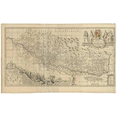
Map of Scotland is an geographic map realized by Johannes Blaeu.
Etching, printed in 1660 ca.
Copper engraving, colored (coeval coloring), on paper, with center fold;
Latin text. Visual size 47.5 x 60.5 cm (f. 51 x 64.5 cm).
Location indicated in the legend at the top left.
Good conditions, except yellowing given by the signs of the time sheet slightly damaged in some parts.
Johannes Blaeu (1596-1673) was a Dutch cartographer, globe maker and publisher. Born in Amsterdam, son of the famous Dutch cartographer Willem Blaeu, he worked with his father in the family business.
Johannes was responsible for publishing some of the most important maps and atlases of the 17th century, including the Atlas Maior, a huge 11-volume work which contained maps from all over the world. The Atlas Maior was a significant achievement in cartography and his maps were noted for their accuracy and beauty. In addition to his work on maps and atlases, Johannes Blaeu was also a skilled globemaker and his globes were much sought after. He produced both terrestrial and celestial globes and his work was known for its accuracy and attention to detail. Johannes Blaeu was also involved in politics, serving as a member of the Amsterdam city council and as a representative to the States General of the Netherlands. He was a respected member of Dutch society and was known for his intellect and scholarship. Overall, Johannes Blaeu was a major figure in the world of cartography and publishing during the 17th century and his work continues to be highly regarded today.
- Creator:Johannes Blaeu
- Creation Year:1650s
- Dimensions:Height: 18.51 in (47 cm)Width: 23.82 in (60.5 cm)Depth: 0.08 in (2 mm)
- Medium:
- Movement & Style:
- Period:1650-1659
- Framing:Framing Options Available
- Condition:Insurance may be requested by customers as additional service, contact us for more information.
- Gallery Location:Roma, IT
- Reference Number:Seller: T-1405721stDibs: LU650312614662
About the Seller
4.9
Platinum Seller
Premium sellers with a 4.7+ rating and 24-hour response times
1stDibs seller since 2017
7,805 sales on 1stDibs
Typical response time: 1 hour
- ShippingRetrieving quote...Shipping from: Grasse, France
- Return Policy
More From This Seller
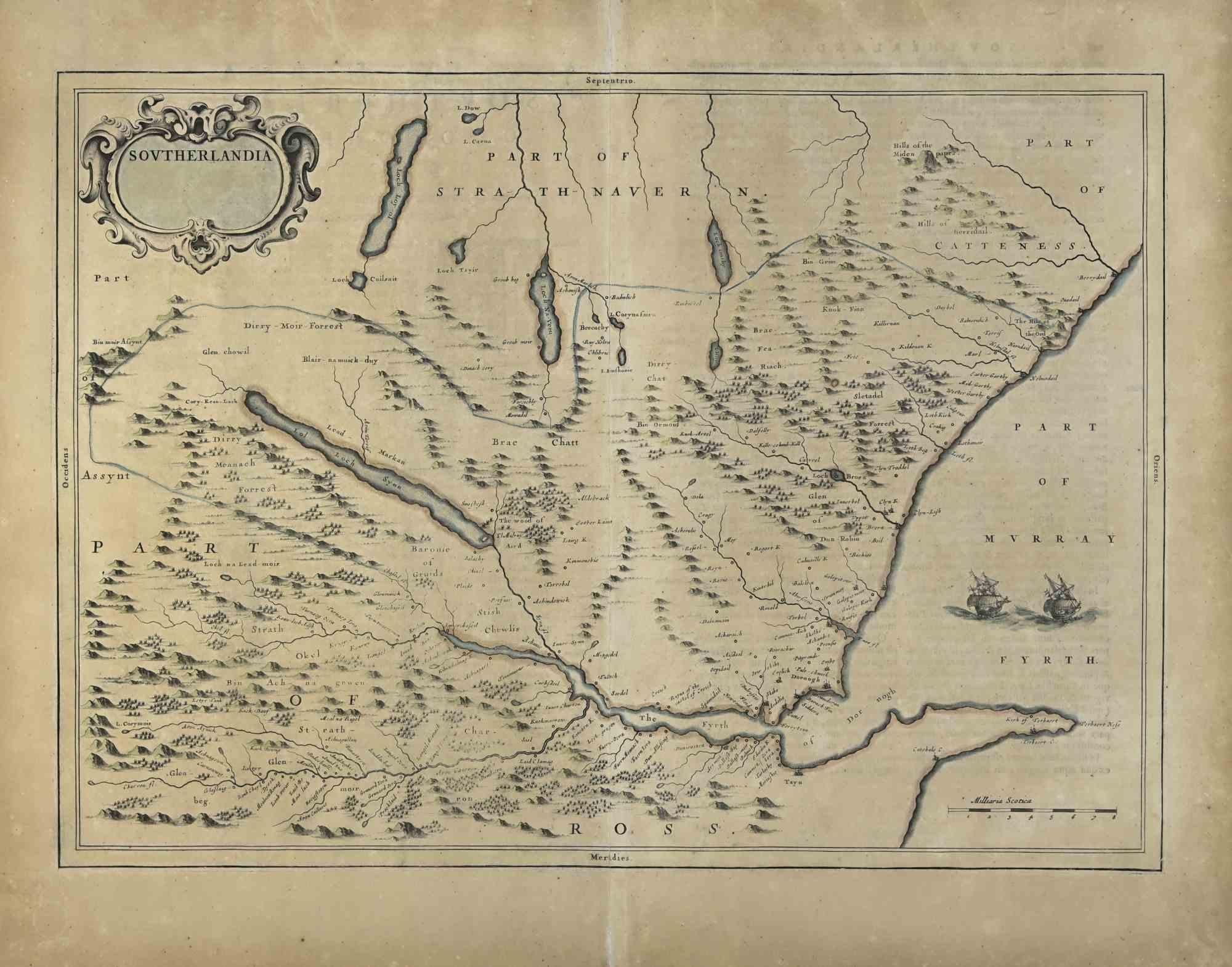
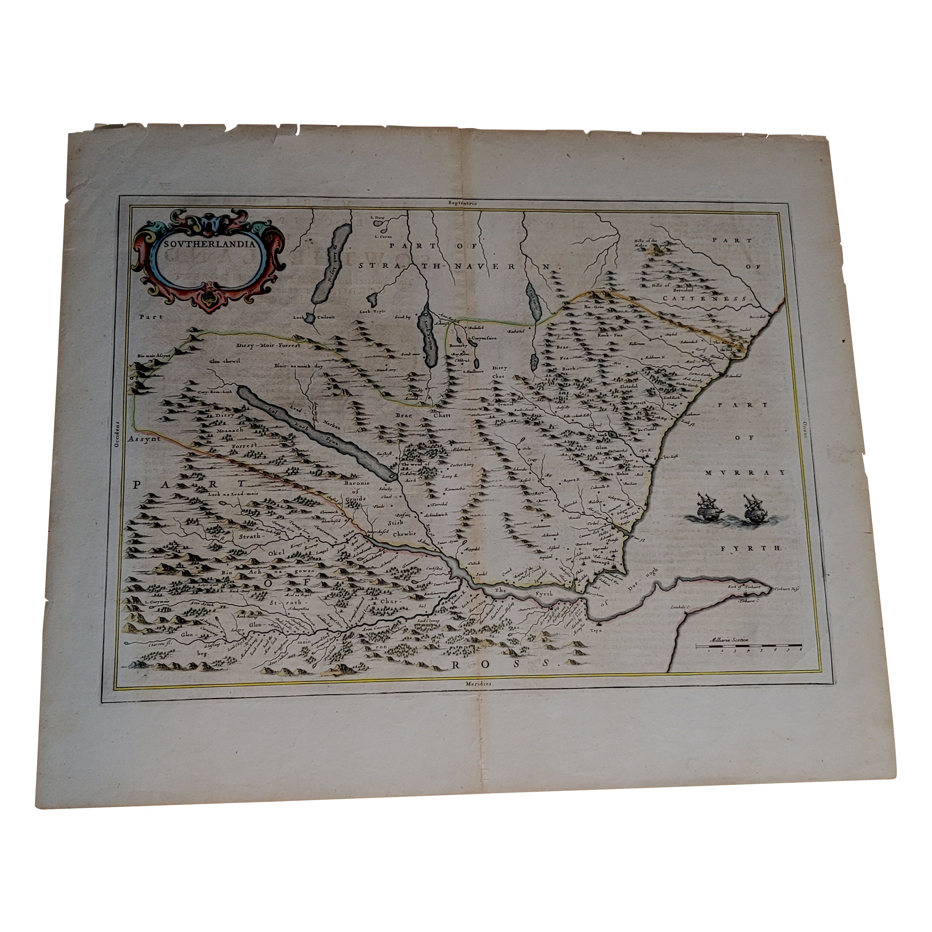
View AllSoutherlandia Map - Etching by Johannes Janssonius - 1650
By Johannes Janssonius
Located in Roma, IT
Southerlandia Map is an ancient map realized in 1650 by Johannes Janssonius (1588-1664).
The Map is Hand-colored etching, with coeval watercoloring.
Good conditions.
From Atlantis...
Category
1650s Modern Figurative Prints
Materials
Etching

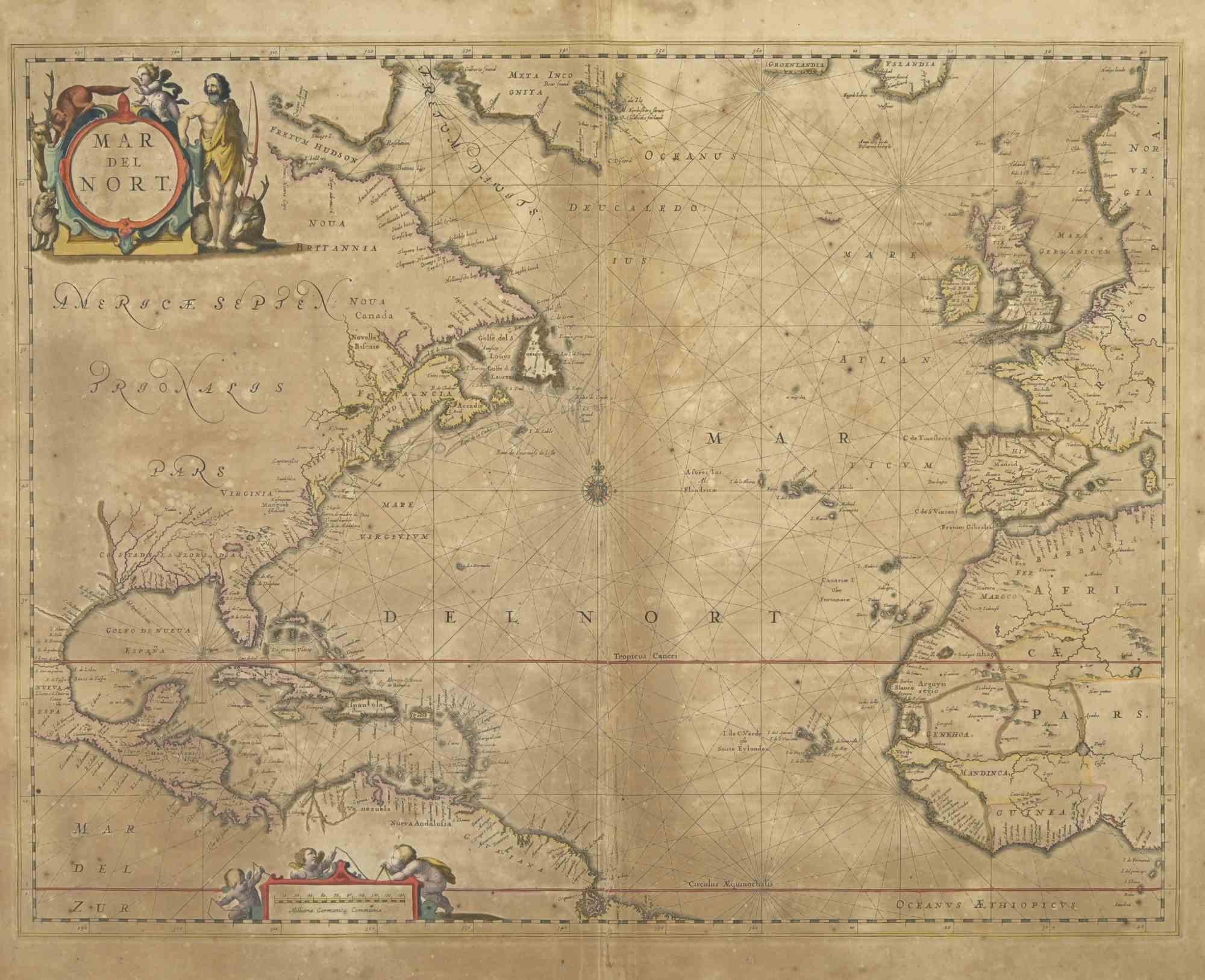
Map of Mar Del Nort - Etching by Johannes Janssonius - 1650s
By Johannes Janssonius
Located in Roma, IT
Antique Map -Mar Del Nort is an antique map realized in 1650 by Johannes Janssonius (1588-1664).
The Map is Hand-colored etching, with coeval watercolorang.
Good conditions with sl...
Category
1650s Modern Figurative Prints
Materials
Etching

Antique Map - Gallia - Etching by Johannes Janssonius - 1650s
By Johannes Janssonius
Located in Roma, IT
Antique Map - Gallia is an antique map realized in 1650 by Johannes Janssonius (1588-1664).
The Map is Hand-colored etching, with coeval watercoloring.
Good conditions with slight ...
Category
1650s Modern Figurative Prints
Materials
Etching

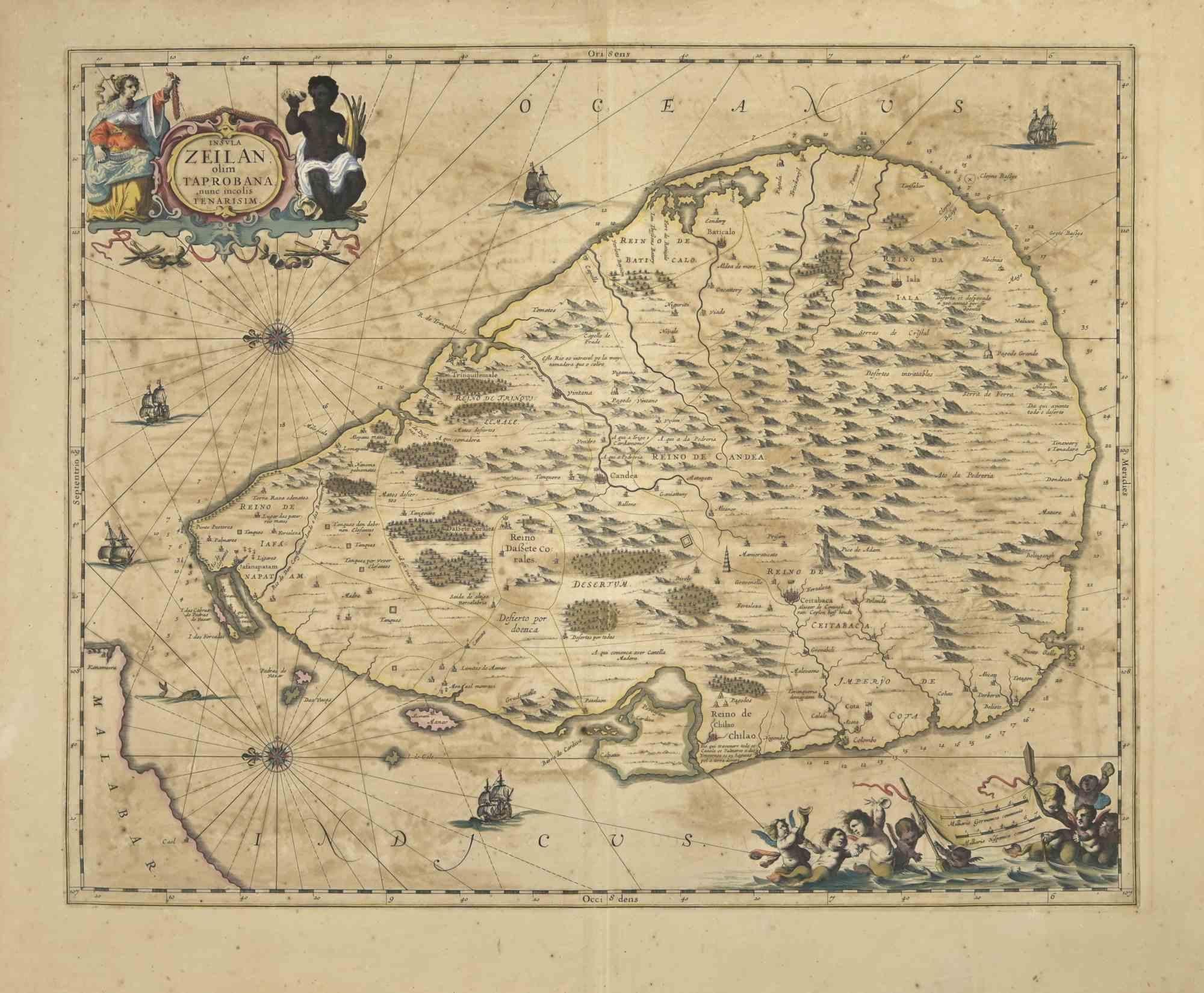
Ancient Map - Zeilan - Etching by Johannes Janssonius - 1650s
By Johannes Janssonius
Located in Roma, IT
Ancient Map - Zeilan is an ancient map realized in 1650 by Johannes Janssonius (1588-1664).
The Map is Hand-colored etching, with coeval watercoloring.
...
Category
1650s Modern Figurative Prints
Materials
Etching

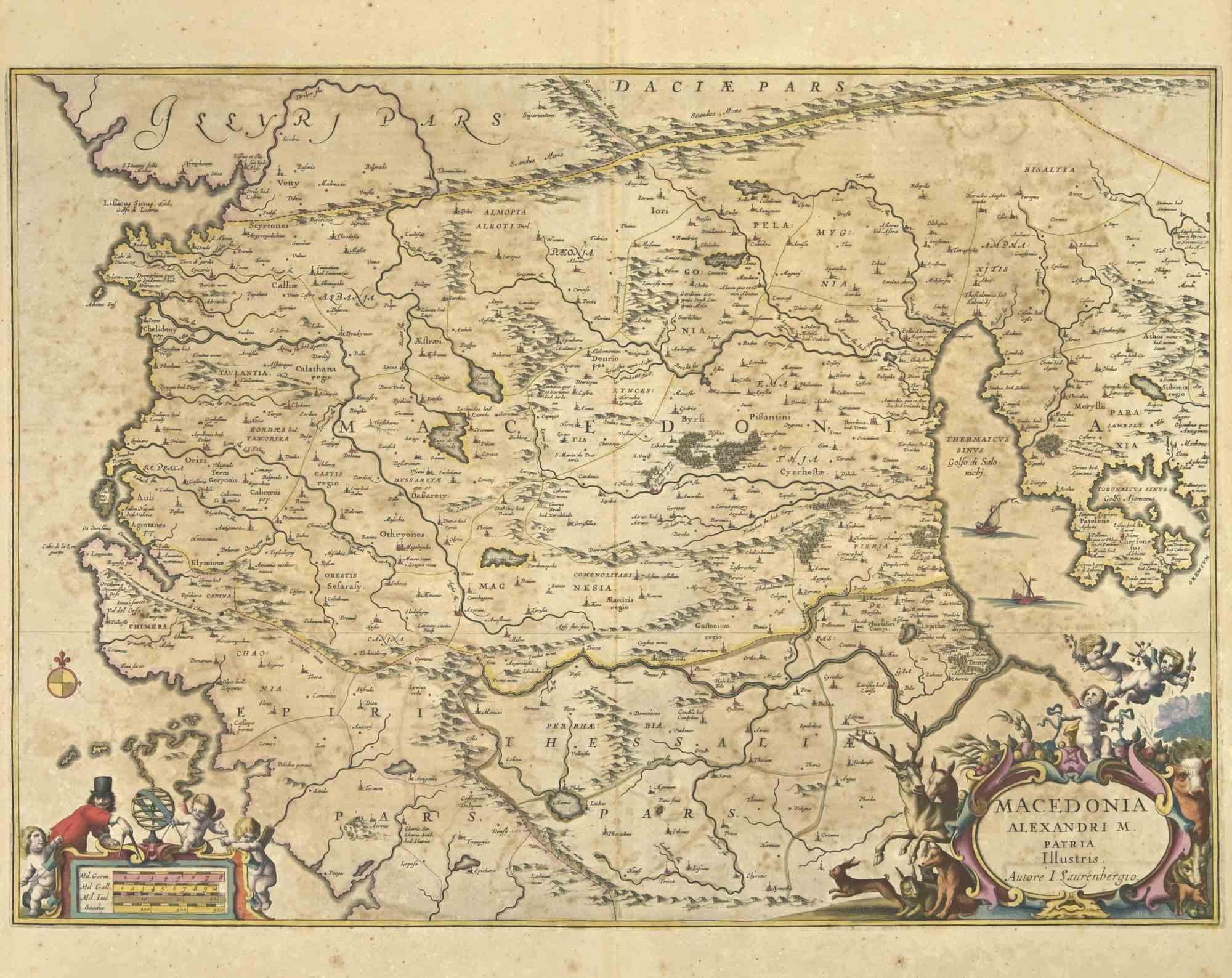
Ancient Map - Macedonia - Etching by Johannes Janssonius - 1650s
By Johannes Janssonius
Located in Roma, IT
Macedonia is an ancient map realized in 1650 by Johannes Janssonius (1588-1664).
The Map is Hand-colored etching, with coeval watercoloring.
Good condit...
Category
1650s Modern Figurative Prints
Materials
Etching

Antique Map - Mar Di Athiopia - Etching by Johannes Janssonius - 1650s
By Johannes Janssonius
Located in Roma, IT
Antique Map - Mar Di Athiopia is an antique map realized in 1650 by Johannes Janssonius (1588-1664).
The Map is Hand-colored etching, with coeval watercolorang.
Good conditions wit...
Category
1650s Modern Figurative Prints
Materials
Etching

You May Also Like
1654 Joan Blaeu Map the Sutherland, Scotland, Entitled "Southerlandia, "Ric0007
Located in Norton, MA
1654 Joan Blaeu map of the
Sutherland, Scotland, entitled
"Southerlandia,"
Hand Colored
Ric0007
Description:
Lovely map centered on Sedan and D...
Category
Antique 17th Century Dutch Maps
Materials
Paper

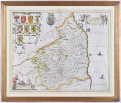
Map of Northumberland by Joan Blaeu
By Joan (Johannes) Blaeu
Located in London, GB
To see our other original maps, scroll down to "More from this Seller" and below it click on "See all from this Seller" - or send us a message if you cannot find the poster you want....
Category
1660s Landscape Prints
Materials
Engraving
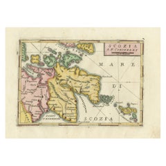
Scozia – Antique Map of Scotland by Coronelli, circa 1690
Located in Langweer, NL
Map of Scotland by Coronelli, c.1690 – “Scozia A.P. Coronelli”
This finely engraved and hand-colored map depicts Scotland, titled Scozia A.P. Coronelli, produced by the renowned Ven...
Category
Antique Late 17th Century Italian Prints
Materials
Paper
Antique Map of Switzerland by J. van Waesbergen, circa 1680
Located in Langweer, NL
Antique map titled 'Vera totius marchionatus Badensis, et Hochbergensis ; ceterorumque ducatuum ladngravionatuum et comitatuum ad principes huius nominis spectantium geometr: astro: ...
Category
Antique Late 17th Century Maps
Materials
Paper
$777 Sale Price
20% Off
Antique Map of Beauce by Janssonius, 1657
By Johannes Janssonius
Located in Langweer, NL
Antique map 'Belsia vulgo la Beausse'. Decorative map of the region of Beauce, a natural region in northern France, located between the Seine and Loire rivers. This map originates fr...
Category
Antique Mid-17th Century Maps
Materials
Paper

Original Antique Map of the Northern Part of Scotland, circa 1640
Located in Langweer, NL
The antique map, titled 'Scotiae pars septentrionalis,' depicts the northern part of Scotland. Crafted by Hondius around 1640, this map is a historical treasure showcasing the geogra...
Category
Antique Mid-17th Century Maps
Materials
Paper
$834 Sale Price
20% Off
More Ways To Browse
Blaeu Maps
Antique Scottish Prints
Scotland Map
Antique Maps Scotland
Antique Celestial Globe
Maria Izquierdo
Nicolas Cochin
Original Etching 16th Century
Paloma Picasso Print
Paris Gallery Poster
Picasso 1966
Picasso Bottle
Picasso Color Lithograph
Picasso Horse Art
Picasso Toro Y Toreros 1959
Pierre Auguste Renoir Le Chapeau Epingle
Pope Innocent
Renoir Chapeau Epingle