Items Similar to Jacques Liozu's 1951 illustrated map of Central and Eastern Europe


Want more images or videos?
Request additional images or videos from the seller
1 of 8
Jacques LiozuJacques Liozu's 1951 illustrated map of Central and Eastern Europe1951
1951
$892.86
£663.64
€750
CA$1,232.80
A$1,367.08
CHF 718.30
MX$16,703.39
NOK 8,986.90
SEK 8,435.74
DKK 5,710.87
About the Item
Jacques Liozu's 1951 illustrated map of Central and Eastern Europe is a cartographic work of great beauty and precision. Jacques Liozu, the famous French artist-cartographer, created this map to delicately depict the varied landscapes and rich cultures of this part of the world.
The map's illustration is a true testament to Liozu's artistic talent. Using delicate colors and detailed patterns, he has depicted the majestic mountain ranges, winding rivers and historic cities of Central and Eastern Europe. Each element is carefully studied to reflect geographical reality while retaining a poetic aesthetic.
This map goes far beyond its informative function. It offers a captivating and immersive vision of the geographical and cultural diversity of this region, inviting the viewer on an imaginary journey through the enchanting landscapes and historical legacies of Central and Eastern Europe.
In 1951, this map was a valuable tool for researchers, students and geography enthusiasts keen to learn more about this complex and historically rich region.
Today, Jacques Liozu's illustrated map of Central and Eastern Europe has become a sought-after collector's item for cartography enthusiasts and art lovers alike. It is a shining testament to Liozu's talent as an artist-cartographer and his ability to transform a geographical map into a striking work of art. This map continues to fascinate and inspire, reminding us of the importance of art in our appreciation and understanding of the world around us.
Central Europe - Map - Eastern Europe
Odé Paris
- Creator:Jacques Liozu (1910 - 1974, French)
- Creation Year:1951
- Dimensions:Height: 22.05 in (56 cm)Width: 16.15 in (41 cm)
- Medium:
- Period:
- Condition:Very good condition.
- Gallery Location:PARIS, FR
- Reference Number:1stDibs: LU1792212725942
About the Seller
5.0
Gold Seller
Premium sellers maintaining a 4.3+ rating and 24-hour response times
Established in 2021
1stDibs seller since 2022
171 sales on 1stDibs
Typical response time: 1 hour
- ShippingRetrieving quote...Shipping from: PARIS, France
- Return Policy
Authenticity Guarantee
In the unlikely event there’s an issue with an item’s authenticity, contact us within 1 year for a full refund. DetailsMoney-Back Guarantee
If your item is not as described, is damaged in transit, or does not arrive, contact us within 7 days for a full refund. Details24-Hour Cancellation
You have a 24-hour grace period in which to reconsider your purchase, with no questions asked.Vetted Professional Sellers
Our world-class sellers must adhere to strict standards for service and quality, maintaining the integrity of our listings.Price-Match Guarantee
If you find that a seller listed the same item for a lower price elsewhere, we’ll match it.Trusted Global Delivery
Our best-in-class carrier network provides specialized shipping options worldwide, including custom delivery.More From This Seller
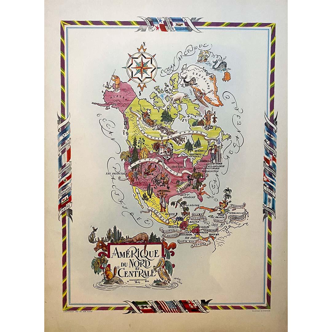
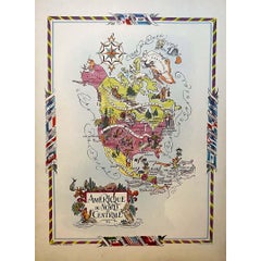
View AllJacques Liozu's 1951 illustrated map of North and Central America
By Jacques Liozu
Located in PARIS, FR
Jacques Liozu's 1951 illustrated map of North and Central America is an exceptional work of cartography that combines geographical precision with artistic aesthetics. Jacques Liozu, ...
Category
1950s Prints and Multiples
Materials
Lithograph, Paper
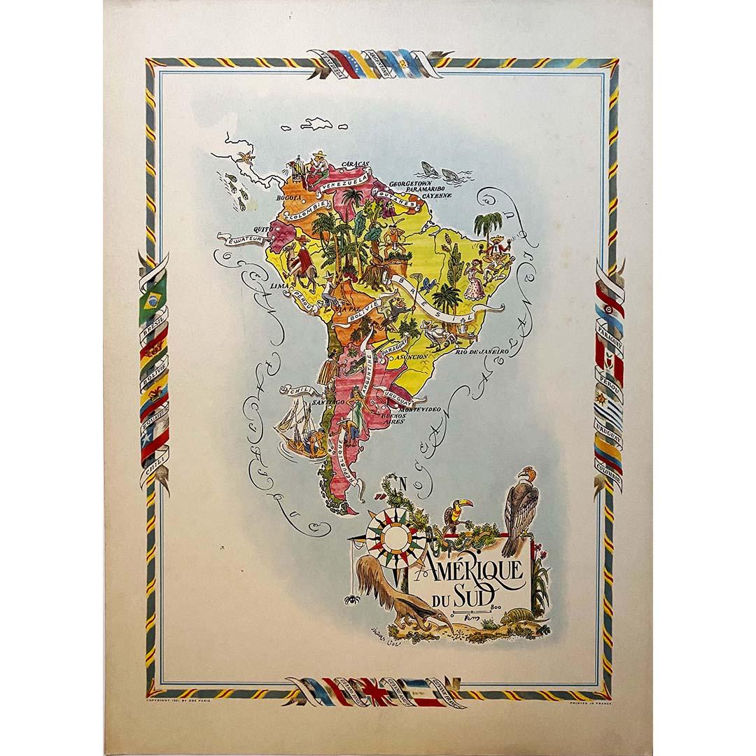
Jacques Liozu's 1951 illustrated map of South America
By Jacques Liozu
Located in PARIS, FR
Jacques Liozu's 1951 illustrated map of South America is an exceptional work of cartography that skilfully blends art and geography. French artist and cartographer Jacques Liozu crea...
Category
1950s Prints and Multiples
Materials
Lithograph, Paper

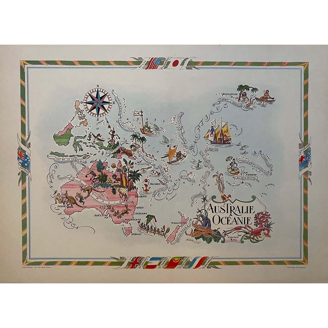
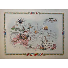
Jacques Liozu's 1951 illustrated map of Australia and Oceania
By Jacques Liozu
Located in PARIS, FR
Jacques Liozu's 1951 illustrated map of Australia and Oceania is a remarkable cartographic work that combines art and geography to offer an enchanting representation of this part of ...
Category
1950s Prints and Multiples
Materials
Lithograph, Paper
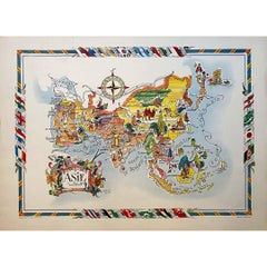
Jacques Liozu's 1951 illustrated map of Asia
By Jacques Liozu
Located in PARIS, FR
Jacques Liozu's 1951 illustrated map of Asia is an exceptional work of cartography that combines art and geography to offer a captivating vision of this vast continent. Jacques Liozu...
Category
1950s Prints and Multiples
Materials
Lithograph, Paper
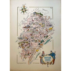
Jacques Liozu's 1951 illustrated map of the region of Franche-Comté
By Jacques Liozu
Located in PARIS, FR
Jacques Liozu's 1951 illustrated map of Franche-Comté is a cartographic work of great beauty and precision. Jacques Liozu, a renowned French artist and cartographer, created this map...
Category
1950s Prints and Multiples
Materials
Lithograph, Paper
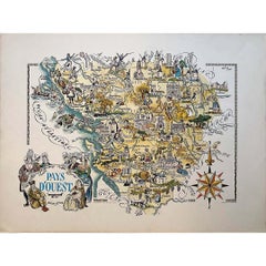
Jacques Liozu's 1951 illustrated map of the region of Pays d'Ouest
By Jacques Liozu
Located in PARIS, FR
Jacques Liozu's 1951 illustrated map of the Pays d'Ouest is a remarkable cartographic work that skilfully combines art and geography. Jacques Liozu, the famous French artist-cartogra...
Category
1950s Prints and Multiples
Materials
Lithograph, Paper
You May Also Like
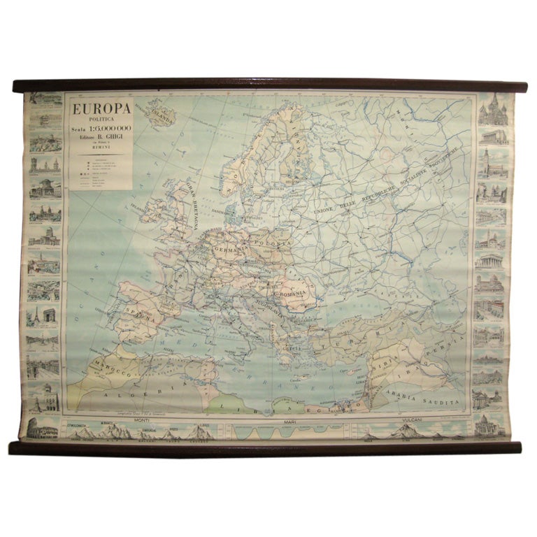
Map of Europe
Located in Los Angeles, CA
28 cities capitol drawings around the border of this Europe political map.
Category
Vintage 1950s Italian Mid-Century Modern Prints
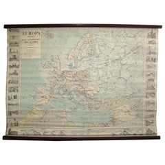
$500
Antique Map of Europe by Hederichs, circa 1740
Located in Langweer, NL
Antique map titled 'Europa Christiani Orbis Domina'. Rare miniature map of Europe. This map originates from 'Anleitung Zu den fürnehmsten Historischen Wissenschaften, Benanntlich Der...
Category
Antique Mid-18th Century Maps
Materials
Paper

$238 Sale Price
20% Off
Antique Map of the European Continent, 1882
Located in Langweer, NL
Antique map titled 'Europe'. Old map of the European continent. This map originates from 'The Royal Atlas of Modern Geography, Exhibiting, in a Series of ...
Category
Antique 19th Century Maps
Materials
Paper

$128 Sale Price
20% Off
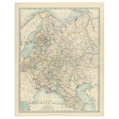
Antique Map of European Russia, 1903, with Colorful Provincial Boundaries
Located in Langweer, NL
Title: Antique Map of European Russia, 1903, with Colorful Provincial Boundaries
Description:
This antique map, titled "European Russia," was engraved and published in 1903 by W. & ...
Category
Early 20th Century Maps
Materials
Paper
Antique Map of Russia in Europe by Johnston (1909)
Located in Langweer, NL
Antique map titled 'European Russia'. Original antique map of Russia in Europe. With inset maps of St Petersburg and Moscow. This map originates from the ‘Royal Atlas of Modern Geogr...
Category
Early 20th Century Maps
Materials
Paper
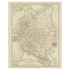
$238 Sale Price
20% Off
Antique Map of Europe by W. G. Blackie, 1859
Located in Langweer, NL
Antique map titled 'Europe'. Original antique map of Europe. This map originates from ‘The Imperial Atlas of Modern Geography’. Published by W. G. Blackie, 1859.
Category
Antique Mid-19th Century Maps
Materials
Paper

$238 Sale Price
20% Off
More Ways To Browse
Illustrated Map
Vintage Europe Map
Cartographer Tool
George Rodrigue Blue Dog Signed
Ballet Russe Costume
Erotic Illustration
German Expressionist Poster
Hiroshige Woodcuts
Imaginations And Objects Of The Future
Lam Wifredo
Marc Chagall Pencil Signed
Pablo Picasso Ceramic Plates
Roy Lichtenstein Signed Lithograph
Van Dyck Etching
Violin Print
Alexander Calder 1969 Lithograph
Green River Project
Retro Pop Machine